Order Total (1 Item Items):
Shipping Destination:

Cram Geo (47 results)
Author:
cram geo
Refine with Advanced Search
Skip to main search results
Search filters
Product Type
- All Product Types
- Books (43)
- Magazines & Periodicals (No further results match this refinement)
- Comics (No further results match this refinement)
- Sheet Music (No further results match this refinement)
- Art, Prints & Posters (No further results match this refinement)
- Photographs (No further results match this refinement)
- Maps (4)
- Manuscripts & Paper Collectibles (No further results match this refinement)
Condition Learn more
- New (No further results match this refinement)
- As New, Fine or Near Fine (No further results match this refinement)
- Very Good or Good (41)
- Fair or Poor (1)
- As Described (5)
Binding
Collectible Attributes
- First Edition (2)
- Signed (No further results match this refinement)
- Dust Jacket (1)
- Seller-Supplied Images (42)
- Not Print on Demand (47)
Language (1)
Free Shipping
- Free Shipping to U.S.A. (No further results match this refinement)
Seller Location
Seller Rating
-

THE EARTH - Illustrating The Correct Use Of The Terrestrial Globe
Published by The Geographical Exchange, Chicago, ILL, 1896
First Edition
Wraps. Condition: Good. 1st edition. 1st edition thus, 1896. A Good copy. 8vo., 24 pp. Dark brown cover wraps with staple spine, front cover missing. Edges chipped, text clean and unmarked. Last three pages are the illustrated signs of the zodiac. George Franklin Cram (1842-1928) was an American map publisher. He served in the U.S. Army during the American Civil War as a first sergeant in Company F of the 105th Illinois Volunteers serving until the end of the war. Upon mustering out he then joined his uncle Rufus Blanchard's Evanston map business in 1867. Two years later, he became sole proprietor of the firm and renamed it the George F. Cram Co. which became a leading map firm in the United States.
-

Illustrated Hand-Book of Geography (Diamond Edition)
Published by Geo. F. Cram, Chicago, 1881
Seller: Book Stall of Rockford, Inc., Rockford, IL, U.S.A.
Association Member: MWABA
Seller rating 5 out of 5 stars

Hardcover. Condition: Very Good. No Jacket. Light wear to the binding. No distortion of the book from reading or improper shelving. Pages are tight and clean with no marks. A number of maps with accompanying texts. The double-page map of the United States has a split in the center fold. No name of previous owner. No odor. Size: 8vo - over 7�" - 9�" tall.
-
ILLUSTRATED HAND-BOOK OF GEOGRAPHY
Published by Geo. F. Cram, Chicago, 1881
Seller: Glenn Books, ABAA, ILAB, Prairie Village, KS, U.S.A.
Seller rating 5 out of 5 stars
First Edition
Brown Cloth. Condition: Light edge and Corner Wear. No Jacket. Diamond Edition. FGront cover lettered in black. Old owner's inscription in fine penmanship, dated '99, on front flyleaf. Frontispiece illustration of "The Little Geographers". Title-page and first three following pages with small brown spot near bottom. Otherwise quite cleran and crisp throughout, no doubt never used by a student. Color maps for ewach country discussed, some double-page. 203pp. + 6-page adverts at end. Size: Square Octavo.
-
CRAM'S ILLUSTRATED ILLUSTRATED HAND-BOOK OF GEOGRAPHY [DIAMOND EDITION]
Published by Geo. F. Cram, Chicago, 1881
Hardcover. Condition: Very Good. 203 pp., 32 Hand Colored Maps, Orig Blue Blindstamped Hardback, edgewear, lacks ff e.p., else VG, Diamond Ed (The Maps are Neat).
-
Decorative Cloth. Condition: Good-. Diamond Edition; maps, illus., frontis.; front panel title and dec. stamped in black ink, no stamping at spine. Binding has edgewear, top of spine is frayed, front hinge has 2-inch crack, though binding is solid; pencilling on ffep, but rest of interior is clean; US map bound in upside down. Scarce in the original edition.
-

13 x 10 inches. Condition: Very good. Early separate map of Birmingham, AL. Multiple printed colors highlight the simple but attractive presentation.
-
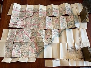
INDEXED RAILROAD AND COUNTY MAP. NORTH AND SOUTH CAROLINA
Published by Chicago, 1880
Seller: Jim Crotts Rare Books, LLC, Clemmons, NC, U.S.A.
Seller rating 2 out of 5 stars

Map
Hardcover in red cloth w/ gold stamped front board, 3.75" x 5.5", 24 pp + map 22x31". Map has many separations along the fold lines.
-
Superior Reference Atlas, Michigan and the World
Published by Geo. F. Cram, 1906
Seller: A Squared Books (Don Dewhirst), South Lyon, MI, U.S.A.
Seller rating 5 out of 5 stars
Hardcover. Condition: Fair. Chicago, 1906; illustrated cloth covered boards; corners and spine edges bumped with board exposed at corners; covers lightly discolored at edges; Folio, 12 to 15 inches tall; text block corners rolled and creased; front end papers toned from news article laid-in; huge gutter gap with back strip exposed and maps held together by binding threads; maps in very good condition with mild foxing; large fold-out map of Michigan tipped in on rear board with wear at folds and corners; interior clean and unmarked; 64 pages. Additional shipping charges may need to be requested due to size or weight of book.
-
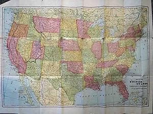
Map of the United States
Published by Chicago c.1902, Chicago, 1902
Seller: High Ridge Books, Inc. - ABAA, South Deerfield, MA, U.S.A.
Association Member: ABAA ESA ILAB SNEAB
Seller rating 5 out of 5 stars
40x58 cm. Folding map in original dark brown wrappers. Spine splitting. Map is excellent, with separations at two fold junctions and short splits along two folds, with no loss. Full color by state. Oklahoma, Arizona and New Mexico are still identified as territories. Tables of populations and statistical information on verso.
-
Blue stiff printed boards, torn at bottom of front with light loss. Map is detached but good, with minor separations at some fold junctions. Outlien color identifying rail lines. 29 pp. index of towns.
-

New Foundland and Labrador
Published by ca. 1901-5, 1901
Seller: Attic Books (ABAC, ILAB), London, ON, Canada
Seller rating 5 out of 5 stars
Map
Condition: Very good. 47 x 65 cm colour map. Pages 46 and 47 of The Imperial Atlas of the Dominion of Canada and the World. Inset shows Labrador. Relief is shown by hachures, a technique used to represent terrain and elevation on maps. The map also shows towns and railroads.
-

1889 Color Map of the State of New Mexico
Published by W.H. Stewart, Rochester, NY, 1889
Seller: RareNonFiction, IOBA, Ladysmith, BC, Canada
Association Member: IOBA
Seller rating 5 out of 5 stars
Map. Condition: Very Good. Cram, Geo. F. (illustrator). First Edition Thus. Outer dimensions: 10.75" x 14.5". Counties individually colored. Clean and unmarked with light wear. An attractive vintage copy.
-
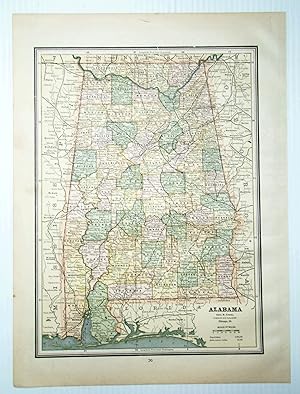
1889 Color Map of the State of Alabama
Published by W.H. Stewart, Rochester, NY, 1889
Seller: RareNonFiction, IOBA, Ladysmith, BC, Canada
Association Member: IOBA
Seller rating 5 out of 5 stars
Map. Condition: Very Good. Cram, Geo. F. (illustrator). First Edition Thus. Outer dimensions: 10.75" x 14.5". Counties individually colored. Clean and unmarked with light wear. An attractive vintage copy.
-
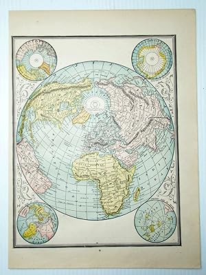
1889 Color Map of the World
Published by W.H. Stewart, Rochester, NY, 1889
Seller: RareNonFiction, IOBA, Ladysmith, BC, Canada
Association Member: IOBA
Seller rating 5 out of 5 stars
Map. Condition: Very Good. Cram, Geo. F. (illustrator). First Edition Thus. Outer dimensions: 10.75" x 14.5". Unmarked with light wear. Color corner illustrations indicate the globe's greatest mass of land, greatest mass of water, north pole regions, and south pole regions. A quality vintage copy.
-
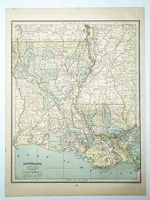
1889 Color Map of the State of Louisiana
Published by W.H. Stewart, Rochester, NY, 1889
Seller: RareNonFiction, IOBA, Ladysmith, BC, Canada
Association Member: IOBA
Seller rating 5 out of 5 stars
Map. Condition: Very Good. Cram, Geo. F. (illustrator). First Edition Thus. Outer dimensions: 10.75" x 14.5". Counties individually colored. Clean and unmarked with light wear. An attractive vintage copy. Bonus: includes separate list of Louisiana counties and cities/towns, complete with their (1889) populations.
-
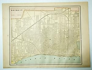
1889 Color City Map of Detroit, Michigan (MI)
Published by W.H. Stewart, Rochester, NY, 1889
Seller: RareNonFiction, IOBA, Ladysmith, BC, Canada
Association Member: IOBA
Seller rating 5 out of 5 stars
Map. Condition: Very Good. Cram, Geo. F. (illustrator). First Edition Thus. Outer dimensions: 10.75" x 14.5". Includes many street names. Steam roads indicated. Clean and unmarked with light wear. An attractive vintage copy.
-
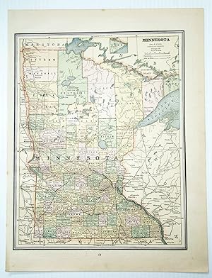
1889 Color Map of the State of Minnesota
Published by W.H. Stewart, Rochester, NY, 1889
Seller: RareNonFiction, IOBA, Ladysmith, BC, Canada
Association Member: IOBA
Seller rating 5 out of 5 stars
Map. Condition: Very Good. Cram, Geo. F. (illustrator). First Edition Thus. Outer dimensions: 10.75" x 14.5". Counties individually colored. Clean and unmarked with light wear. An attractive vintage copy.
-
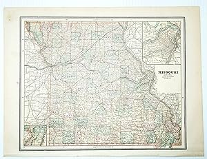
1889 Color Map of the State of Missouri
Published by W.H. Stewart, Rochester, NY, 1889
Seller: RareNonFiction, IOBA, Ladysmith, BC, Canada
Association Member: IOBA
Seller rating 5 out of 5 stars
Map. Condition: Very Good. Cram, Geo. F. (illustrator). First Edition Thus. Outer dimensions: 10.75" x 14.5". Counties individually colored. Clean and unmarked with light wear. A quality vintage copy. Bonus: includes separate extensive list of Missouri counties and cities/towns, complete with (1889) population of each.
-
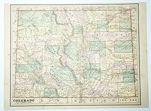
1889 Color Map of the State of Colorado
Published by W.H. Stewart, Rochester, NY, 1889
Seller: RareNonFiction, IOBA, Ladysmith, BC, Canada
Association Member: IOBA
Seller rating 5 out of 5 stars
Map. Condition: Very Good. Cram, Geo. F. (illustrator). First Edition Thus. Outer dimensions: 10.75" x 14.5". Counties individually colored. Clean and unmarked with light wear. An attractive vintage copy.
-
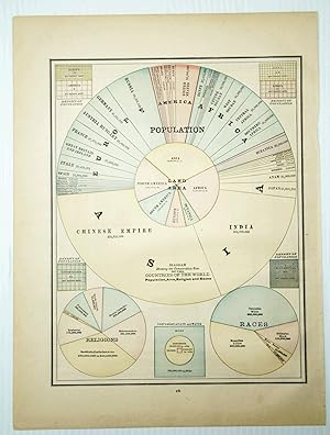
1889 Color Pie Charts of World Population By Country, Continent, Religion and Race
Published by W.H. Stewart, Rochester, NY, 1889
Seller: RareNonFiction, IOBA, Ladysmith, BC, Canada
Association Member: IOBA
Seller rating 5 out of 5 stars
Map. Condition: Very Good. Cram, Geo. F. (illustrator). First Edition Thus. Outer dimensions: 10.75" x 14.5". A fascinating and informative presentation of the population of the world in 1889. Main pie chart breaks illustrates the world's population by country and continent. Smaller pie charts present world population by religion and race. Clean and unmarked with light wear. A quality vintage copy.
-

1889 Color Map of the State of Kansas
Published by W.H. Stewart, Rochester, NY, 1889
Seller: RareNonFiction, IOBA, Ladysmith, BC, Canada
Association Member: IOBA
Seller rating 5 out of 5 stars
Map. Condition: Very Good. Cram, Geo. F. (illustrator). First Edition Thus. Outer dimensions: 10.75" x 14.5". Counties individually colored. Clean and unmarked with light wear. A quality vintage copy. Bonus: includes separate extensive list of Kansas counties and cities/towns, complete with (1889) population of each.
-
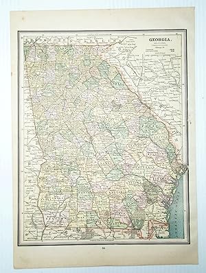
1889 Color Map of the State of Georgia
Published by W.H. Stewart, Rochester, NY, 1889
Seller: RareNonFiction, IOBA, Ladysmith, BC, Canada
Association Member: IOBA
Seller rating 5 out of 5 stars
Map. Condition: Very Good. Cram, Geo. F. (illustrator). First Edition Thus. Outer dimensions: 10.75" x 14.5". Counties individually colored. Clean and unmarked with light wear. An attractive vintage copy.
-
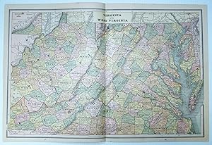
1889 Color Map of the States of Virginia and West Virginia
Published by W.H. Stewart, Rochester, NY, 1889
Seller: RareNonFiction, IOBA, Ladysmith, BC, Canada
Association Member: IOBA
Seller rating 5 out of 5 stars
Map. Condition: Very Good. Cram, Geo. F. (illustrator). First Edition Thus. Vintage state map with counties individually colored. Outer dimensions: 21.75" x 14.5". Unmarked with light wear. Center fold. A quality example. Bonus: includes separate extensive list of counties and towns/cities for each state, indicating (1889) population of each.
-
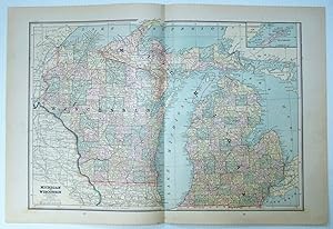
1889 Color Map of Wisconsin and Michigan
Published by W.H. Stewart, Rochester, NY, 1889
Seller: RareNonFiction, IOBA, Ladysmith, BC, Canada
Association Member: IOBA
Seller rating 5 out of 5 stars
Map. Condition: Very Good. Cram, Geo. F. (illustrator). First Edition Thus. Vintage state map with counties individually colored. Outer dimensions: 21.75" x 14.5". Unmarked with light wear. Center fold. A quality example. Bonus: includes separate extensive list of counties and towns/cities of Michigan, indicating (1889) population of each.
-
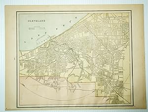
1889 Color City Map of Cleveland, Ohio (OH)
Published by W.H. Stewart, Rochester, NY, 1889
Seller: RareNonFiction, IOBA, Ladysmith, BC, Canada
Association Member: IOBA
Seller rating 5 out of 5 stars
Map. Condition: Very Good. Cram, Geo. F. (illustrator). First Edition Thus. Outer dimensions: 10.75" x 14.5". Includes many street names. Clean and unmarked with light wear. An attractive vintage copy.
-

1889 Color Map of the City of Montreal, Quebec
Published by W.H. Stewart, Rochester, NY, 1889
Seller: RareNonFiction, IOBA, Ladysmith, BC, Canada
Association Member: IOBA
Seller rating 5 out of 5 stars
Map. Condition: Very Good. Cram, Geo. F. (illustrator). First Edition Thus. Outer dimensions: 10.75" x 14.5". Includes many street names and locations of interest. Clean and unmarked with light wear. An attractive vintage copy. Text in English.
-
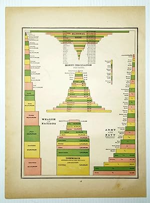
1889 Color Bar Graphs Comparing the Wealth, National Debt, Money Circulation, Commerce, and Army/Navy Size of the Nations of the World
Published by W.H. Stewart, Rochester, NY, 1889
Seller: RareNonFiction, IOBA, Ladysmith, BC, Canada
Association Member: IOBA
Seller rating 5 out of 5 stars
Map. Condition: Very Good. Cram, Geo. F. (illustrator). First Edition Thus. Outer dimensions: 10.75" x 14.5". A fascinating and informative graphical presentation of the vital economic statistics of the world's nations in 1889. Offers a stunning contrast to the economic power displayed today by the nations of Asia. Suitable for mounting on the wall of any far-sighted investment professional. Clean and unmarked with light wear. A quality vintage copy.
-

1889 Color Map of the State of Arizona
Published by W.H. Stewart, Rochester, NY, 1889
Seller: RareNonFiction, IOBA, Ladysmith, BC, Canada
Association Member: IOBA
Seller rating 5 out of 5 stars
Map. Condition: Very Good. Cram, Geo. F. (illustrator). First Edition Thus. Outer dimensions: 10.75" x 14.5". Counties individually colored. Clean and unmarked with light wear. An attractive vintage copy. Bonus: includes separate extensive list of Arizona counties and cities/towns, complete with their (1889) populations.
-

1889 Color Map of the State of Florida
Published by W.H. Stewart, Rochester, NY, 1889
Seller: RareNonFiction, IOBA, Ladysmith, BC, Canada
Association Member: IOBA
Seller rating 5 out of 5 stars
Map. Condition: Very Good. Cram, Geo. F. (illustrator). First Edition Thus. Outer dimensions: 10.75" x 14.5". Counties individually colored. Clean and unmarked with light wear. An attractive vintage copy. Bonus: includes separate extensive list of Florida counties and towns/cities, complete with their populations in 1889.
-

1889 Color Map of the State of Montana
Published by W.H. Stewart, Rochester, NY, 1889
Seller: RareNonFiction, IOBA, Ladysmith, BC, Canada
Association Member: IOBA
Seller rating 5 out of 5 stars
Map. Condition: Very Good. Cram, Geo. F. (illustrator). First Edition Thus. Outer dimensions: 21.75" x 14.5". Counties individually colored. Clean and unmarked with light wear. A handsome vintage copy.