
Order Total (1 Item Items):
Shipping Destination:

Corps Engineers U S a (39 results)
Skip to main search results
Search filters
Product Type
- All Product Types
- Books (31)
- Magazines & Periodicals (1)
- Comics (No further results match this refinement)
- Sheet Music (No further results match this refinement)
- Art, Prints & Posters (No further results match this refinement)
- Photographs (No further results match this refinement)
- Maps (7)
- Manuscripts & Paper Collectibles (No further results match this refinement)
Condition Learn more
- New (22)
- As New, Fine or Near Fine (3)
- Very Good or Good (7)
- Fair or Poor (No further results match this refinement)
- As Described (7)
Binding
Collectible Attributes
- First Edition (5)
- Signed (No further results match this refinement)
- Dust Jacket (No further results match this refinement)
- Seller-Supplied Images (25)
- Not Print on Demand (26)
Language (2)
Free Shipping
Seller Location
Seller Rating
-

The U.S. Army Corps of Engineers Response to the EXXON Valdez Oil Spill
Language: English
Published by University Press of the Pacific, New York
ISBN 10: 1410222535 ISBN 13: 9781410222534
First Edition
Softcover. Condition: Good. No Jacket. First Edition. The wraps are lightly creased, but the book looks brand new inside. The binding is nice and tight. Electronic delivery tracking will be issued free of charge.
-

AMS Bulletins (Number 13, December 1944) - COLOR
Language: English
Published by AMS, Corps of Engineers (US Army), 1944
Magazine / Periodical
Soft cover. Condition: Very Good. A vintage government bulletin from 1944. Published by the AMS (Army Map Service) to provide timely information on important trends and developments in topography, cartography, photography, and lithographic reproduction. Includes two articles: "Elementary Color Theory in Photography" and "Color Proving on Ansco Color Paper". Illustrated throughout in color and black and white with charts, diagrams, etc. Measures 8" x 10.5" with 47 pages. Marked 'RESTRICTED' on the front cover. Other than a note written on the cover, there are no other marks of any kind.
-
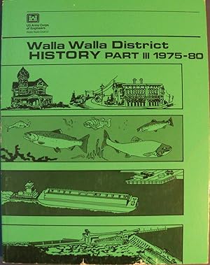
WALLA WALLA DISTRICT HISTORY PART III 1975-80 (1980)
Published by U.S. ARMY CORPS OF ENGINEERS, 1980
Soft cover. Condition: Very Good. very good+ large soft cover / light edge and corner tip wear / light library stamp on first page / internals appear clean and unmarked / many illustrations, maps, and photographs.
-

Condition: As New. Unread book in perfect condition.
-

-

The Built Environment of Cold War Era Servicewomen (ERDC/CERL M-06-2)
Seller: Rarewaves.com USA, London, LONDO, United Kingdom
Seller rating 5 out of 5 stars

Paperback. Condition: New.
-

The Built Environment of Cold War Era Servicewomen (ERDC/CERL M-06-2)
Language: English
Published by Military Bookshop 2006-08-30, 2006
ISBN 10: 1782663061 ISBN 13: 9781782663065
Paperback. Condition: New.
-
The Built Environment of Cold War Era Servicewomen (ERDC/CERL M-06-2)
Seller: Ria Christie Collections, Uxbridge, United Kingdom
Seller rating 5 out of 5 stars
� 23.97
� 11.98 shipping
Ships from United Kingdom to U.S.A.Quantity: Over 20 available
Add to basketCondition: New. In.
-

The Built Environment of Cold War Era Servicewomen (ERDC/CERL M-06-2)
Seller: GreatBookPricesUK, Woodford Green, United Kingdom
Seller rating 5 out of 5 stars
Condition: New.
-

The Built Environment of Cold War Era Servicewomen (ERDC/CERL M-06-2)
Seller: GreatBookPricesUK, Woodford Green, United Kingdom
Seller rating 5 out of 5 stars
Condition: As New. Unread book in perfect condition.
-

The Built Environment of Cold War Era Servicewomen (ERDC/CERL M-06-2)
Seller: Ria Christie Collections, Uxbridge, United Kingdom
Seller rating 5 out of 5 stars
� 38.20
� 11.98 shipping
Ships from United Kingdom to U.S.A.Quantity: Over 20 available
Add to basketCondition: New. In.
-

Corps of Engineers Water Resources Infrastructure: Deterioration, Investment, or Divestment?
Language: English
Published by National Academies Press, 2013
ISBN 10: 0309264766 ISBN 13: 9780309264761
Seller: Kennys Bookshop and Art Galleries Ltd., Galway, GY, Ireland
Seller rating 5 out of 5 stars
Condition: New. Num Pages: 120 pages, colour tables, maps. BIC Classification: RBKF. Category: (P) Professional & Vocational. Dimension: 280 x 216 x 8. Weight in Grams: 181. . 2013. Illustrated. paperback. . . . .
-
Corps of Engineers Water Resources Infrastructure: Deterioration, Investment, or Divestment?
Language: English
Published by National Academies Press, 2013
ISBN 10: 0309264766 ISBN 13: 9780309264761
Condition: New. Num Pages: 120 pages, colour tables, maps. BIC Classification: RBKF. Category: (P) Professional & Vocational. Dimension: 280 x 216 x 8. Weight in Grams: 181. . 2013. Illustrated. paperback. . . . . Books ship from the US and Ireland.
-
Paperback. Condition: New.
-
[Mapa de] CHOISEUL ISLAND, Melanesia
Published by Army Map Service, 1944
Seller: Librer�a Miguel Miranda, Lope de Vega n.� XIX, Madrid, M, Spain
Seller rating 5 out of 5 stars
Map
Condition: Good / Bien. Washington: Army Map Service, [ca. 1959?].- Mapa en colores plegado de 64,5 x 55 cm, Scale 1: 500.000; Refer to this map as: SHEET SB 57-4 Series X401; Texto en ingl�s. Tan solo tiene los nombres de algunos pueblos o zonas costeras manuscritos a bol�grafo azul. Por lo dem�s en perfecto estado. Book in english GEOGRAF�A, GU�AS Y ATLAS DEL EXTRANJERO.
-
Hardcover. Condition: Like New. Like New. book.
-

Belvoir (VA. ; MD. Fort Belvoir and vicinity). Refer to this map as: Sheet 5561 II NW
Published by Army Map Service, 1956
Seller: Librer�a Miguel Miranda, Lope de Vega n.� XIX, Madrid, M, Spain
Seller rating 5 out of 5 stars
Map
Condition: Good / Bien. Washington: Army Map Service, [ca. 1956].- Es un mapa a escala 1 : 25.000 en colores y plegado, de 71 x 54,4 cm; Texto en ingl�s.- Al verso tiene la totograf�a a�rea del �rea cartografiada en el mapa. Excelente estado. Book in english GEOGRAF�A, GU�AS Y ATLAS DEL EXTRANJERO.
-
[Mapa de] MAUI, Hawiian Islands
Published by Army Map Service, 1952
Seller: Librer�a Miguel Miranda, Lope de Vega n.� XIX, Madrid, M, Spain
Seller rating 5 out of 5 stars
Map
Condition: Good / Bien. Washington: Army Map Service, [ca. 1952].- Mapa en colores plegado de 54,5 x 68,2 cm, Scale 1: 250.000, Location diagram for NF 4-16; Texto en ingl�s. Excelente estado. Book in english GEOGRAF�A, GU�AS Y ATLAS DEL EXTRANJERO.
-
[Mapa de] OAHU = HONOLULU , Hawaiian Islands
Published by Army Map Service, 1952
Seller: Librer�a Miguel Miranda, Lope de Vega n.� XIX, Madrid, M, Spain
Seller rating 5 out of 5 stars
Map
Condition: Good / Bien. Washington: Army Map Service, [ca. 1952].- Mapa en colores plegado de 55,5 x 72,5 cm, Scale 1: 250.000, Location diagram for NF 4-11; Texto en ingl�s. Excelente estado. Book in english GEOGRAF�A, GU�AS Y ATLAS DEL EXTRANJERO.
-

Methodology for Recreation Data Acquisition and Evaluation for Ethnic Minority Visitors to Corps of Engineers Projects. Technical Report R-99-September 1999.
Published by U.S. Army Corps of Engineers, Washington, DC
First Edition
Softcover. Condition: Very Good. No Jacket. First Edition. Softcovers encased in plastic sleeve. Very Good+ condition. An organization is stamp neatly marked out on the title page; otherwise, the report is NEW. The covers are in great shape. The binding is square and tight. The interior pages are clean and unmarked. The book will be carefully packaged for shipment for protection from the elements. USPS electronic tracking number issued free of charge. A survey was conducted at five Corps of Engineers (CE) lakes during the spring and summer of 1999 to obtain baseline information about the outdoor recreation style and preferences of these ethnic minority groups (African, Hispanic, and Asian Americans) and their experiences and perceptions at CE projects. This report documents the results of that survey. The study also tested the draft survey instrument against results obtained in four focus group interviews which were conducted in 1998 at the same CE lakes. The 1999 survey population included African Americans at Woodruff Lake, AL, and Carlyle Lake, IL; Hispanic Americans at Canyon Lake, TX, and Pine Flat Lake, CA; and Asian Americans at Hensley Lake, CA, and Pine Flat Lake, CA. The survey was conducted from May 15 to July 30, 1999. While Native Americans were not included in this survey, the report contains a discussion of six focus groups which were conducted during the summer of 1997 with fifteen Native American tribes located in the CE's Tulsa and Omaha Districts.
-
Environmental Value of Riparian Vegetation
Published by U.S. Army Corps of Engineers, Waterways Experiment Station [Environmental Laboratory], Washington, DC
First Edition
Softcover. Condition: Very Good. No Jacket. First Edition. Rare title in Very Good to Near Fine condition. The covers are in great shape. The binding is square and tight. An organization stamp is neatly marked out on the title page. The interior pages are clean and unmarked. The book will be carefully packaged for shipment for protection from the elements. Contains 147 pages and Appendices (187 pp. in all). USPS electronic tracking number issued free of charge. The U.S. Army Corps of Engineers develops- river projects across the country that have potential impacts on the vegetation in areas adjacent to the river, called riparian corridors. As part of the project review process, the impact of the proposed project on the environment must be evaluated. Information about the environmental value of riparian vegetation is difficult to access, because it is diffuse in the literature. RESEARCH OBJECTIVE: The objective of this research is to review the literature for information pertinent to assessing the environmental value of riparian vegetation. SUMMARY: Vegetation contributes greatly to the hydraulic, hydrologic, water quality, and life support functions commonly performed in riparian corridors. The resistance to flow by vegetation reduces flow velocity and the energy of flowing water that erodes shorelines and carries suspended sediments. Bank materials are bound and supported by roots. Vegetated watersheds help to stabilize baseflow rates by increasing infiltration and permeability of soils. The result is that vegetation helps to stabilize stream morphology and hydrology and attenuate floods. In addition, suspended solids and dissolved chemicals and nutrients in river water are reduced proportionately with residence time in vegetated floodplain. Riparian vegetation provides food, refuge, and nesting areas for a diverse array of terrestrial and aquatic fauna. Losses of riparian vegetation can lead, therefore, to a destabilization of stream morphology, alteration of hydrology, degraded water quality, and reductions in many types of fish and wildlife.
-
![Seller image for [Mapa de] FUKUOKA - KORURA (Japan) for sale by Librer�a Miguel Miranda](https://pictures.abebooks.com/inventory/md/md31942264459.jpg)
[Mapa de] FUKUOKA - KORURA (Japan)
Published by Army Map Service, 1954
Seller: Librer�a Miguel Miranda, Lope de Vega n.� XIX, Madrid, M, Spain
Seller rating 5 out of 5 stars
Map
Condition: Good / Bien. Washington: Army Map Service, [ca. 1954?].- Mapa en colores plegado de 142 x 115,3 cm, Scale 1: 250.000; Texto en ingl�s. Los bordes est�n reforzados con papel adhesivo. Salvo esto, el mapa en buen estado. Book in english GEOGRAF�A, GU�AS Y ATLAS DEL EXTRANJERO.
-
PAP. Condition: New. New Book. Shipped from UK. THIS BOOK IS PRINTED ON DEMAND. Established seller since 2000.
-
[Two maps] CENTRAL JAPAN and SOUTHERN JAPAN
Published by Army Map Service, 1957
Seller: Librer�a Miguel Miranda, Lope de Vega n.� XIX, Madrid, M, Spain
Seller rating 5 out of 5 stars
Map
Condition: Good / Bien. Washington: Army Map Service, [ca.1957?].- Two color maps folded, 102 x 64 cm (Central) and 71 x 75,5 cm (Southern); Scale 1:1.000.000; Texto en ingl�s. Tienen en los bordes se�ales de haber estado pegados con papel celof�n adhesivo. En general buen estado. Book in english GEOGRAF�A, GU�AS Y ATLAS DEL EXTRANJERO.
-
The Built Environment of Cold War Era Servicewomen ERDCCERL M062
Seller: PBShop.store UK, Fairford, GLOS, United Kingdom
Seller rating 4 out of 5 stars

� 23.47
� 5.02 shipping
Ships from United Kingdom to U.S.A.Quantity: Over 20 available
Add to basketPAP. Condition: New. New Book. Delivered from our UK warehouse in 4 to 14 business days. THIS BOOK IS PRINTED ON DEMAND. Established seller since 2000.
-
Four adjoining US Army maps Series K462, Edition 1-AMS: (1) NG 39-W: Western Persian Gulf, Saudi Arabia, Bahrain, Qatar / (2) NG 39-E: Central Persian Gulf, Arabia, Iran / (3) NF 39-W: Northwestern Rub al Khali, Saudi Arabia / (4) NF 39-E: Northeastern Rub al Khali, Saudi Arabia, Edition 1-AMS
Language: English
Published by United States Army, Washington DC, 1964
Map First Edition
No Binding. Condition: Good. 1st Edition. A set of four adjoining US Army K462 Series colour printed maps, including the very significant Western Persian Gulf sheet. Each approx 85x100cm, adapted from Aramco-USGS originals. All stated first editions, first printings dated Feb 1964 (Edition 1-AMS). Good overall. Neatly folded with pinholes to some corners and edges, some wear along folds, occasional small areas of staining, and the original USGS map numbers in ms to the edges. The originals were prepared as part of the groundbreaking USGS-Aramco mapping exercise for the Saudi Government during 1956-63. One of its main products was a series of Geographic maps divided into 21 Quadrangles on a 1/500K scale, numbered I-200B to I-220B. These along with their geological equivalents were designed to support exploration and exploitation of petroleum, minerals, and groundwater. Evidenced by this set, the Geographic series also proved highly valuable to the US Army's Corps of Engineers, which was supporting Saudi Arabia through a massive long-term construction and infrastructure development programme. The AMS additions include a Universal Transverse Mercator grid, and marginal data revised to 1963. The maps are labelled in English and Arabic, including a Glossary, sources of base compilation, and Index Map. Details include international boundaries (where they exist), settlements of various sizes (including ruins, date gardens, and cultivated areas); transport (rail and stations, types of road and camel tracks, landing fields and airports). Hydrogaphic features include wells, wadis etc. Hypsographic features include descriptions of different types of sand terrain. Miscellaneous features include oil and gas installations. The sheets adjoin in 2 rows of 2, between them covering the area bounded by Safaniyah (NW), Gezdan (NE), Uruq (SE), and Al Arawik (SW), taking in all of Qatar and Bahrain, parts of Saudi Arabia and Iran, and parts of what would become the UAE. SHEETS: (1) NG 39-W: Western Persian Gulf, Saudi Arabia, Bahrain, Qatar. Copied from Map I-208B originally prepared in 1958 by a joint Aramco-USGS team including Max Steineke, TF Harriss, KR Parsons, and EL Berg. This covers the Gulf coast from Safaniyah to the western half of Qatar, including all of Bahrain, and the key Aramco locations including Al Khobar, Dhahran, Dammam, Jubail, Ras Tanura, Abqaiq, etc. Installations include the Trans-Arabian Pipeline with Tapline Road and the Al Qatif-Al Qaysumah Pipeline that feeds into it, with the Saudi Government Railroad to the lower edge. Among significant local sites are the port of Uqair, Hofuf Oasis, and the Darb Al Uqayr connecting them, and other ancient camel trails including Darb Huwwijan, Darb Mazalij, Darb Mikhyat, and Darb Az Zuayyini. Installations and settlements are also shown in Bahrain and Qatar, with partially defined maritime boundaries. // (2) NG 39-E: Central Persian Gulf, Arabia, Iran. Copied from Map I-209B originally prepared in 1959 by Aramco's Richard Bramkamp and Leon Ramirez. Extending eastward from NG 39-W, this covers the Arabian coast from the eastern half of Qatar to Ar Ruways, and the Iranian coast from the islands of Jabrin to Jazireh-ye Qeys. // (3) NF 39-W: Northwestern Rub al Khali, Saudi Arabia. Copied from Map I-213B originally prepared in 1959 by Bramkamp and Ramirez. This is the continuation inland of NG 39-W. // (4) NF 39-E: Northeastern Rub al Khali, Saudi Arabia. Copied from Map I-214B originally prepared in 1959 by Bramkamp and Ramirez. Extending westward from NF 39-W and southwards from NG 39-E.
-

Reports Upon the Survey of the Boundary Between the Territory of the United States and The Possessions of Great Britain From the Lake of the Woods to the Summit of the Rocky Mountains, Authorized by An Act of Congress Approved March 19, 1872 Published in Accordance With an Act of Congress Approved March 3, 1877
Published by Government Printing Office, Washington DC, 1878
Seller: Americana Books, ABAA, Stone Mt, GA, U.S.A.
Association Member: ABAA ESA ILAB IOBA
Seller rating 5 out of 5 stars
First Edition
Hardcover. Condition: Good. First Edition. Folio. Approx. 12" tall. 621 pages. Restored. Brownish marbled paper covered boards with brown leather corners and spine. 5 raised bands, gilt lines, decorations and gilt title on the spine. New blueish floral decorated end papers. Blue cloth linen hinges. Title page has a small perforation at the bottom. Evidence of sticker or label removal on the verso of the title page and on the back of map 7 in the rear. Illustrated with 15 tinted lithograph views; 7 large folding numbered maps in back; and 7 folding maps, diagrams, and sketches in the text. Many of the maps have taped repairs on the verso and on the folding edges. Page 83 is repaired. Page 300 is chipped in the upper corner. Text is very clean. This is a survey of border between United States and Canada along the 49th Parallel. Views include an Ojibway Camp, a Sioux Grave, Badlands, Assinniboine Camp, Rocky Mountain Falls, the Camp at Pine Ridge - Departure of the Dog Trains, and many more.
-
HRD. Condition: New. New Book. Shipped from UK. THIS BOOK IS PRINTED ON DEMAND. Established seller since 2000.
-
The Built Environment of Cold War Era Servicewomen ERDCCERL M062
Seller: PBShop.store UK, Fairford, GLOS, United Kingdom
Seller rating 5 out of 5 stars
� 38.10
� 6.76 shipping
Ships from United Kingdom to U.S.A.Quantity: Over 20 available
Add to basketHRD. Condition: New. New Book. Delivered from our UK warehouse in 4 to 14 business days. THIS BOOK IS PRINTED ON DEMAND. Established seller since 2000.
-
Leather Bound. Condition: New. Language: English. Language: English. Presenting an Exquisite Leather-Bound Edition, expertly crafted with Original Natural Leather that gracefully adorns the spine and corners. The allure continues with Golden Leaf Printing that adds a touch of elegance, while Hand Embossing on the rounded spine lends an artistic flair. This masterpiece has been meticulously reprinted in 2025, utilizing the invaluable guidance of the original edition published many years ago in 1981. The contents of this book are presented in classic black and white. Its durability is ensured through a meticulous sewing binding technique, enhancing its longevity. Imprinted on top-tier quality paper. A team of professionals has expertly processed each page, delicately preserving its content without alteration. Due to the vintage nature of these books, every page has been manually restored for legibility. However, in certain instances, occasional blurriness, missing segments, or faint black spots might persist. We sincerely hope for your understanding of the challenges we faced with these books. Recognizing their significance for readers seeking insight into our historical treasure, we've diligently restored and reissued them. Our intention is to offer this valuable resource once again. We eagerly await your feedback, hoping that you'll find it appealing and will generously share your thoughts and recommendations. Lang: - English, Vol:- Volume 1981, Pages:- 50, Print on Demand. If it is a multi-volume set, then it is only a single volume. We are specialised in Customisation of books, if you wish to opt different color leather binding, you may contact us. This service is chargeable. Product Disclaimer: Kindly be informed that, owing to the inherent nature of leather as a natural material, minor discolorations or textural variations may be perceptible. Explore the FOLIO EDITION (12x19 Inches): Available Upon Request. Volume 1981 50 50.
![Seller image for [Mapa de] CHOISEUL ISLAND, Melanesia for sale by Librer�a Miguel Miranda](https://pictures.abebooks.com/inventory/md/md31942268035.jpg)
![Seller image for [Mapa de] MAUI, Hawiian Islands for sale by Librer�a Miguel Miranda](https://pictures.abebooks.com/inventory/md/md31942264458.jpg)
![Seller image for [Mapa de] OAHU = HONOLULU , Hawaiian Islands for sale by Librer�a Miguel Miranda](https://pictures.abebooks.com/inventory/md/md31942258737.jpg)

![Seller image for [Two maps] CENTRAL JAPAN and SOUTHERN JAPAN for sale by Librer�a Miguel Miranda](https://pictures.abebooks.com/inventory/md/md31942254820.jpg)

![Seller image for Stream channel stability : Appendix C : Investigations of vegetation for stabilizing eroding stream banks : Probect Objective 2 Volume 1981 1981 [Leather Bound] for sale by Gyan Books Pvt. Ltd.](https://pictures.abebooks.com/inventory/md/md31958287977.jpg)