Order Total (1 Item Items):
Shipping Destination:

Clason Map (56 results)
Skip to main search results
Search filters
Product Type
- All Product Types
- Books (42)
- Magazines & Periodicals (No further results match this refinement)
- Comics (No further results match this refinement)
- Sheet Music (No further results match this refinement)
- Art, Prints & Posters (No further results match this refinement)
- Photographs (No further results match this refinement)
- Maps (14)
- Manuscripts & Paper Collectibles (No further results match this refinement)
Condition Learn more
Binding
Collectible Attributes
- First Edition (5)
- Signed (No further results match this refinement)
- Dust Jacket (No further results match this refinement)
- Seller-Supplied Images (53)
- Not Print on Demand (53)
Language (2)
Free Shipping
Seller Location
Seller Rating
-

Clason's Wisconsin Green Guide With Road And Railway Maps
Language: English
Published by Clason Map Co, Chicago
Soft cover. Condition: Fair. No Jacket. 47 Pages; Staple Binding; Pages Tight; Yellowed; Moderate Page Wear; No Markings On Pages. Faded Green Soft Covers With Border And Black Lettering And Illustration On Covers. Wear On Spine Ends, Edges; Some Rubbing. No Date But Cir 1920'S. Contains Information On State And City Maps; Auto Road Logs; Railroads; Commercial Index Of Towns Giving Hotels, Industries, Altitudes, Population, Etc. Many Maps And Image Of State Capitol At Madison. Sections On: Auto Road Section; Cities And Towns; Counties; Educational Institutions; Lakes; Hotels, Madison Map; Milwaukee Maps; Railroads; Rivers; State Institutions. Rear Page Provides Chard Of The Shortest Railroad Mileage Between Wisconsin Towns. Very Rare Vintage Copy.
-
No Binding. Condition: Very Good. 13 x 7" map printed in color on one side that folds to about 2 x 3" and fits into a stiff card folder printed in blue. Front panel of card folder has the following information: "Compliments of F.M. Luther & Sons Brokers, Cimarron, Kansas." Map is in near fine condition with one short separation closed with archival repair and no markings. Card stock folder slightly worn and slightly soiled. The Clason Map Company operated in Denver from the early 1900s until the Depression. It published numerous maps in different forms, including a "midget map" series. The distributor of this map, F. M. Luther & Sons, was a real estate brokerage headed by Francis [Frank] Luther, one of the founders of Cimarron, Kansas. I dated this map using a couple of named Kansas highways. The Carrie Nation Highway was established in 1917 and is shown on this map; but this map lacks a "Victory Highway" which was designated ca. 1921. A relatively rare map of Kansas.
-
Clason's Guide Map of MISSOURI
Published by The Clason Map Co.,, Denver, Colorado, 1885
Map First Edition
No Binding. Condition: Very Good. No Jacket. 1st Edition. 46 x 61 cm, thin paper was folded small, colored in outline , roads, railroads in red, inset of St. Louis and Vicinity, [ on right side of map] INDEX MISSOURI, Cities and Towns with Population of 700 or More Date is roughly estimated from map contents. Many original folds, a few separations on horizontal folds and some stains on back which leak through lightly.
-
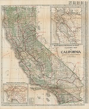
Index Map of California: Clason's Commercial Inex of California towns gives populations, elevations, hotels, banks, industries and railroads
Published by The Clason Map Co, 1914
First Edition
Saddle-stapled wraps. Condition: Near Fine. First Edition. 16mo - over 5�" - 6�" An exceptional copy of this scarce early California motoring guide with the large folding color map, in the original green wraps printed in black and yellow. A nice, crisp copy with the map cross-folded with one minor tear; in Near Fine condition.
-
Clason's Double Indexed Map of Chicago - The Chicago of Al Capone.
Published by c. 1926, 1926
Seller: Curtis Wright Maps, Berwyn, IL, U.S.A.
Seller rating 5 out of 5 stars

Condition: Very Good. This interesting map of Chicago, Illinois was published locally by the Clason Map Company around 1926, based on the presence of Soldier Field and the absence of any reference to Midway Airport. It provides a detailed look at the Windy City during the Roaring 20s, when Al Capone was at his height, jazz music blared, and speakeasies flourished with bootleg booze. The image presents a complex network of transportation routes - streets, electric & steam railroads, streetcar lines, and the iconic elevated lines, known affectionately as the 'L'. Neighborhoods, parks, and cemeteries are labeled, along with unique locations of interest like the Aero Club of Illinois, Union Stockyards, Hawthorne Race Track, and the tuberculosis sanitarium. Also of interest is the outline of proposed developments along the lakefront. A nearby inset in the center-right shows the Chicago Loop (the business district), while the borders provide street numbering information and an alphabetical street index. Handwritten annotations note the location of Theo. Ebert & Co. (a decorating and design company) on the north and west sides of the city. Sheet Width (in) 22 Sheet Height (in) 34 Condition Description Large pocket map folded into 30 panels and disbound from original paper wraps (present). Toning in the upper left panels and moderate wear along folds. Old manuscript annotations in pen. Good condition overall. Blank on verso.
-
Clason's Touring Atlas of the United States
Published by Denver & Chicago c.1925, Denver & Chicago, 1925
Seller: High Ridge Books, Inc. - ABAA, South Deerfield, MA, U.S.A.
Association Member: ABAA ESA ILAB SNEAB
Seller rating 5 out of 5 stars
31x21.5 cm. Illustrated colored wrappers. Good to very good condition with wear and rubbing at sides. 48 pp. Uncolored maps of each of the United States plus southern Ontario and Quebec. Clason was a significant map publisher of the early 20th century, generally focused on the western United States. Their atlases, mostly from the 1920's, are quite scarce. See Rumsey 13359 for what appears to be the same atlas with a different name and wrappers.
-
Clason's Guide Map of Denver and Suburbs
Published by Chicago & Denver c. 1925, Chicago & Denver, 1925
Seller: High Ridge Books, Inc. - ABAA, South Deerfield, MA, U.S.A.
Association Member: ABAA ESA ILAB SNEAB
Seller rating 5 out of 5 stars
Folding map in Clason's Denver Map Guide. Stiff illustrated wrappers in very good condition, with light wear at edges. Includes 40 pp. text with street name index, extensive descriptions of notable sites, buildings and parks in the city, with a double-page plan of the tramway routes and a single-page map of the business district.
-
Clason's Guide Map of Colorado
Published by Denver c.1912, Denver, 1912
Seller: High Ridge Books, Inc. - ABAA, South Deerfield, MA, U.S.A.
Association Member: ABAA ESA ILAB SNEAB
Seller rating 5 out of 5 stars
43x55 cm. Folding map in original stiff illustrated wrappers, near mint condition. 56 pp. text. Rail lines are highlighted in red. The text (16x10 cm.) contains single-page uncolored maps of the business districts of Denver, Colorado Springs and Pueblo.
-
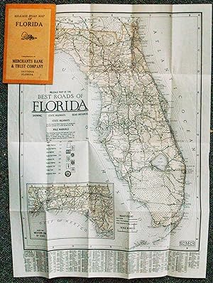
Mileage Map of the Best Roads of Florida, Showing State Highways, Road Distances, State Highways
Published by Chicago, Chicago, 1924
Seller: High Ridge Books, Inc. - ABAA, South Deerfield, MA, U.S.A.
Association Member: ABAA ESA ILAB SNEAB
Seller rating 5 out of 5 stars
Small folding map in fine condition. Stiff orange printed wrappers, 1924-25 calendar inside front cover, ad for Merchant's Bank and Trust Co. of Daytona on the back cover. The map, lightly tinted, shows the road system of Florida, with "best roads" and "other thoroughfares" identified. Distances between towns is noted. The panhandle is shown on an inset map. The map also keys the nine different signs which designate the major roads through the state. These signs were posted periodically on poles along these routes. Index of towns, with populations, at the bottom. While Clason was a major maker of maps during this period, most of their maps dealt with areas west of the Mississippi River.
-
CLASON'S NEVADA GREEN GUIDE
Published by The Clason Map Company, n. d. (ca 1920)., Chicago, Denver, 1920
Seller: BUCKINGHAM BOOKS, ABAA, ILAB, IOBA, GREENCASTLE, PA, U.S.A.
Association Member: ABAA ILAB IOBA RMABA TXBA
Seller rating 4 out of 5 stars

First Edition
First edition. 6 1/4" x 4" green pictorial stiff wrappers printed in black,16 pp., index to Nevada towns, state and city maps, automobile road logs, railroads, hotels, industries, altitudes, population, etc. A fold-out map at the front presents a mileage map of the transcontinental trails of the United States on one side and on the other side a mileage map of the best roads of California and Nevada. Affixed to the rear cover is a color map of Nevada. Both maps are in fine condition. Covers lightly used and rubbed , else a very good copy with light wear to the spine ends and corners.
-
Sketch Map of New Mexico
Published by Denver c.1910, Denver, 1910
Seller: High Ridge Books, Inc. - ABAA, South Deerfield, MA, U.S.A.
Association Member: ABAA ESA ILAB SNEAB
Seller rating 5 out of 5 stars
Very small uncolored map of New Mexico. Folds into 8.5x5 cm. printed boards. Two short tears mended. Small stains on boards. Issued as a promotional item for the Alamo Real Estate Loan and Insurance Co. of Alamogordo, New Mexico. This small map is considerably rarer than the larger Clason series of maps of western states.
-
INDEX TO MAP OF UTAH
Published by The Clason Map Company, 1911., Denver, 1911
Seller: BUCKINGHAM BOOKS, ABAA, ILAB, IOBA, GREENCASTLE, PA, U.S.A.
Association Member: ABAA ILAB IOBA RMABA TXBA
Seller rating 4 out of 5 stars
First Edition
First edition. 6 1/4" x 4" green pictorial stiff wrappers printed in black, 32 pp., index to Utah towns, rivers and creeks, mountains and peaks, valleys and deserts, lakes, plus railroad distances and railroad distances between Utah towns. The color fold-out map of Utah is bight and and colorful. 3" closed split to lower edge of map at fold as well as 1/2" closed split to top edge of map at fold. Folder is clean and tight.
-
City and Harbor of Los Angeles [panel title]
Published by Los Angeles: Security Trust & Savings Bank, 1921, 1921
Seller: James Arsenault & Company, ABAA, Arrowsic, ME, U.S.A.
Association Member: ABAA ESA ILAB
Seller rating 5 out of 5 stars
Map
Brochure incorporating three maps, 7" x 3.75" folded; sheet size 28" x 21", single map printed on one side (24" x 20.5"), text and two maps on verso, one map 18" x 13" and other 20.5" x 6.5". CONDITION: Very good, a few small holes at folds, toning and two inch separation along one fold. A map brochure issued by the Security Trust and Savings Bank of Los Angeles, intended to promote the city, to advertise the bank, and to closely identify the growth of the city with the growth of the bank. Appearing on the recto is "The Map of the City of Los Angeles" extending from Griffith Park in the north to the beginning of the "Shoestring" strip in the south, and west from Huntington Avenue to the (former) intersection of Sunset Boulevard and Holloway Drive. Four capitalized letters indicate "The Four Security Corners," ie., where the four branches of the Security Trust and Savings Bank can be found. One is located "in the heart of the Downtown Section," another serves "the Ninth End of the Business District," another is available near the "West End of the Shopping District," and the fourth, the "Cahuenga Building," is the "largest Banking Institution in Hollywood." Numbers along the border mark the thoroughfares from Los Angeles to nearby towns and neighborhoods including Los Angeles' Harbor, San Francisco, San Diego, Culver City, and Redondo Beach. All of these are identified in a key below the map. There is an additional inset map on the right edge ("Insert A"), an enlarged view of the neighborhoods around Huntington Avenue. On the verso is a map of the "Complete City of Los Angeles" showing the entirety of Los Angeles including the Shoestring addition of 1909, as well as un-annexed towns and additions in the greater L.A. region. Also included is a map of"the Shoestring" and Los Angeles Harbor accompanied by a note on its history. Other notes cover such matters as "Growth of the City and the Growth of the Bank," the square mileage covered by the city, and its internal improvements, especially the construction of its aqueduct. The Security Trust and Savings Bank was a prominent financial institution in late nineteenth and early twentieth century Los Angeles and served as "one of the principal banks used by Hollywood for financing films (including those of Cecil B. DeMille), and for maintaining personal fortunes (Howard Hughes, Charlie Chaplin, and W. C. Fields are said to have had accounts at this bank)" ("Security Trust"). Their Cahuenga building in Hollywood was the tallest building in Hollywood in 1921, serving as a popular filming location of the silent film era. In fact, Raymond Chandler gave his iconic private eye, Philip Marlowe, an office there "on the sixth floor, two small rooms at the back. One I left open for a patient client to sit in, if I had a patient client" ("Cahuenga Building"). REFERENCES: "Cahuenga Building" at Atlas Obscura online; "Security Trust and Savings Bank, California," at Center for Land Use and Interpretation online.
-
Easy Fold Maps of California Highways
Published by Clason Map Company, 1920
Seller: Barry Lawrence Ruderman, La Jolla, CA, U.S.A.
Seller rating 5 out of 5 stars
Map
No Binding. Condition: VG. Clason Map Company / 1920 / Easy Fold Maps of California Highways (Box 27, 73977) Folding map. Covers somewhat toned and worn. Early California road atlas, published by Edward Doheny's California Petroleum Corporation. Includes 4 larger road maps of sections of California and smaller city maps of major cities, including Los Angeles, San Diego, Long Beach, San Francisco, Oakland, San Jose, Santa Barbara, Sacramento, Fresno, and the East Bay. Map.
-
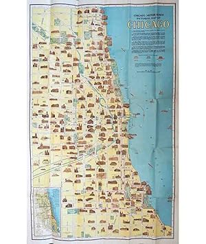
Chicago Motor Coach Pictorial Map of Chicago
Published by Chicago c.1925, Chicago, 1925
Seller: High Ridge Books, Inc. - ABAA, South Deerfield, MA, U.S.A.
Association Member: ABAA ESA ILAB SNEAB
Seller rating 5 out of 5 stars
Folding, double-sided map in original printed stiff wrappers. fine condition. The map on the recto shows much of the city of Chicago. The verso has a Pictorial Map of Downtown Chicago, showing the area from Grant Park (Seventh Street) in the south to Bellevue Place in the north. Extends west to just past the Chicago River. Both sides depict important or prominent buildings, including office buildings, hotels, libraries, hospitals and churches. The date is derived from the name Grant Park Stadium which is used at the illustration of Soldier Field. The name of the stadium was changed to Soldier Field in 1925. It is also clearly pre-1930 as the Merchandise Mart, opened in that year, is not present. A wonderful depiction of Chicago at the height of the 1920's.
-
Highways of Colorado - Official Guide and Tour Book
Published by Denver, Denver, 1912
Seller: High Ridge Books, Inc. - ABAA, South Deerfield, MA, U.S.A.
Association Member: ABAA ESA ILAB SNEAB
Seller rating 5 out of 5 stars
A road atlas of Colorado designed for automobile drivers. Original illustrated stiff wrappers. Top and bottom of backstrip torn, otherwise excellent condition. 192 pp. with 84 uncolored maps and many photographic illustrations in the text. This was the first auto travel guide issued by a state governmental authority. Motor Age magazine for May 30, 1912: "Nearly half of the 192 pages of the book are devoted to maps, and the text pages are generaously illustrated with many of Colorado's most famous and wonderful scenes. The different routes are idnetified by the preservation of the names applied to them when they were old, historic trails." A rare and important piece of Colorado history from the earliest days of automobile travel in the American West. OCLC 18713787 (8 loc.).
-
![Seller image for Clason's Oklahoma green guide : state and city maps, auto road logs, railroads : commercial index of towns giving hotels, industries, altitudes, population, etc 1920 [LeatherBound] for sale by True World of Books](https://pictures.abebooks.com/inventory/md/md31618557707.jpg)
LeatherBound. Condition: New. BOOKS ARE EXEMPT FROM IMPORT DUTIES AND TARIFFS; NO EXTRA CHARGES APPLY. LeatherBound edition. Condition: New. Reprinted from 1920 edition. Leather Binding on Spine and Corners with Golden leaf printing on spine. Bound in genuine leather with Satin ribbon page markers and Spine with raised gilt bands. A perfect gift for your loved ones. Pages: 46 NO changes have been made to the original text. This is NOT a retyped or an ocr'd reprint. Illustrations, Index, if any, are included in black and white. Each page is checked manually before printing. As this print on demand book is reprinted from a very old book, there could be some missing or flawed pages, but we always try to make the book as complete as possible. Fold-outs, if any, are not part of the book. If the original book was published in multiple volumes then this reprint is of only one volume, not the whole set. Sewing binding for longer life, where the book block is actually sewn (smythe sewn/section sewn) with thread before binding which results in a more durable type of binding. Pages: 46.
-
![Seller image for Clason's Montana green guide : state and city maps, auto road logs, railroads : commercial index of towns giving hotels, industries, altitudes, population, etc 1921 [LeatherBound] for sale by True World of Books](https://pictures.abebooks.com/inventory/md/md31618560110.jpg)
LeatherBound. Condition: New. BOOKS ARE EXEMPT FROM IMPORT DUTIES AND TARIFFS; NO EXTRA CHARGES APPLY. LeatherBound edition. Condition: New. Reprinted from 1921 edition. Leather Binding on Spine and Corners with Golden leaf printing on spine. Bound in genuine leather with Satin ribbon page markers and Spine with raised gilt bands. A perfect gift for your loved ones. Pages: 50 NO changes have been made to the original text. This is NOT a retyped or an ocr'd reprint. Illustrations, Index, if any, are included in black and white. Each page is checked manually before printing. As this print on demand book is reprinted from a very old book, there could be some missing or flawed pages, but we always try to make the book as complete as possible. Fold-outs, if any, are not part of the book. If the original book was published in multiple volumes then this reprint is of only one volume, not the whole set. Sewing binding for longer life, where the book block is actually sewn (smythe sewn/section sewn) with thread before binding which results in a more durable type of binding. Pages: 50.
-
Leather Bound. Condition: New. Language: English. Presenting an Exquisite Leather-Bound Edition, expertly crafted with Original Natural Leather that gracefully adorns the spine and corners. The allure continues with Golden Leaf Printing that adds a touch of elegance, while Hand Embossing on the rounded spine lends an artistic flair. This masterpiece has been meticulously reprinted in 2025, utilizing the invaluable guidance of the original edition published many years ago in 1921. The contents of this book are presented in classic black and white. Its durability is ensured through a meticulous sewing binding technique, enhancing its longevity. Imprinted on top-tier quality paper. A team of professionals has expertly processed each page, delicately preserving its content without alteration. Due to the vintage nature of these books, every page has been manually restored for legibility. However, in certain instances, occasional blurriness, missing segments, or faint black spots might persist. We sincerely hope for your understanding of the challenges we faced with these books. Recognizing their significance for readers seeking insight into our historical treasure, we've diligently restored and reissued them. Our intention is to offer this valuable resource once again. We eagerly await your feedback, hoping that you'll find it appealing and will generously share your thoughts and recommendations. Lang: - English, Pages:- 50, Print on Demand. If it is a multi-volume set, then it is only a single volume. We are specialised in Customisation of books, if you wish to opt different color leather binding, you may contact us. This service is chargeable. Product Disclaimer: Kindly be informed that, owing to the inherent nature of leather as a natural material, minor discolorations or textural variations may be perceptible. Explore the FOLIO EDITION (12x19 Inches): Available Upon Request. 50.
-
Seeing Chicago the Motor Coach Way - "Open Air to Everywhere" along the lines of the Chicago Motor Coach Company."
Published by c. 1923, 1923
Seller: Curtis Wright Maps, Berwyn, IL, U.S.A.
Seller rating 5 out of 5 stars
Condition: Fine. This interesting pocket map and tour guide to Chicago was published around 1923 by the Clason Map Company. It was distributed as a promotional item on behalf of the Chicago Motor Coach Company, which operated bus tours on three routes across the North, West, and South Sides of the Windy City. These are shown in brown, green, and orange, respectively, in the simple street plan of the city in the upper left. Nearly 80 points of interest - parks, beaches, hotels, and more - are numbered and identified in the adjacent list. Competing transit options like the elevated railway and streetcar lines are omitted from the image. The lower portion of the sheet is occupied by an overview of the Shopping District Service, including a Shopper's Map of the Loop that names many of the city's major merchants. The verso provides several small photographs and descriptive text of major attractions along each of the three tours. Discussion on the ongoing construction of Tribune Tower helps to date the map conclusively between 1923 and 1925. Sheet Width (in) 11.5 Sheet Height (in) 18 Condition Description Pocket map folded into 16 panels and affixed to original stiff paper wraps, as issued. Light wear along fold, including small pinholes at seam intersections. Near fine condition overall.
-
Clason's Map of California - California's roads in the midst of the Roaring '20s.
Published by c. 1924, 1924
Seller: Curtis Wright Maps, Berwyn, IL, U.S.A.
Seller rating 5 out of 5 stars
Condition: Very Good. This fabulously detailed road map of California shows the burgeoning transportation network across the state in the mid-1920s. Main roads predate the numbered highway system and are individually labeled, like the Roosevelt National Trail, El Camino Real, and Pike's Peak Ocean to Ocean Highway. The various paths were undoubtedly surfaced with a variety of materials like macadam, gravel, dirt, and tar - there's even a wooden 'planked road' across the desert of Imperial County. Inset maps of the San Francisco and Los Angeles areas can be seen in the upper right and lower left, respectively. Published around 1924 in Denver by the Clason Map Company. Includes the accompanying guidebook, which presents more detailed street plans of California urban centers and an extensive index of cities and towns. Sheet Width (in) 27.5 Sheet Height (in) 33.75 Condition Description Originally issued folded into 48 panels, now separated from accompanying guidebook (64 pp., still present) and flattened. Former separation at fold intersections has been repaired on the verso, along with a few small edge tears. Minor discoloration and light offsetting visible in a few places, but overall the map and book both remain in good condition.
-
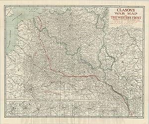
Clason's War Map of the Western Front - Exhaustive survey of the Western Front in the final year of the First World War.
Published by c. 1955, 1955
Seller: Curtis Wright Maps, Berwyn, IL, U.S.A.
Seller rating 5 out of 5 stars
Condition: Fine. "This detailed map of the Western Front of WWI shows the lines of Allied advance as they tried to expel the German army from France in September of 1918. Earlier hashed lines show the tremendous gains Germany had made earlier in the war with the (almost) successful implementation of the Schlieffen Plan - a huge "right hook" that cut through Belgium southwards to Paris. The line of furthest advance highlights just how close they came to besieging the city - barely 40 miles. The bottom of the sheet presents a number of inset maps showing the primary fortresses in Belgium and France, including the myriad of satellite forts surrounding each. In these maps, it's easy to visualize how such complex networks of immense fortifications contributed to the static nature of trench warfare that came to define the First World War." Sheet Width (in) 34 Sheet Height (in) 28 Condition Description As issued originally -folded into fifty panels and affixed to two tone pictorial paper covers. Moderate creasing along the fold lines, though no discoloration or breakage. The covers are worn and a bit soiled. Near fine condition overall.
-
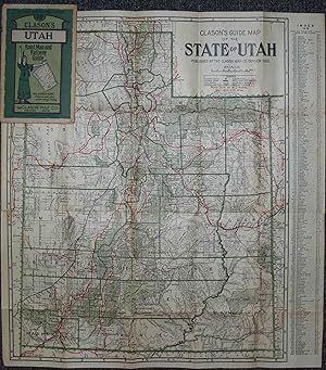
Clason's Guide Map of Utah
Published by Chicago & Denver c. 1919, Chicago & Denver, 1919
Seller: High Ridge Books, Inc. - ABAA, South Deerfield, MA, U.S.A.
Association Member: ABAA ESA ILAB SNEAB
Seller rating 5 out of 5 stars
Folding map in Clason's Utah Green Guide. Very good condition, with light wear at edges and one short mended tear to the map. Includes 32 pp. text with place name index, lists of roads and railroads, descriptive information about the state, small uncolored maps of Salt Lake City and the roads into and out of the city. Map is brightly colored, with roads, railroads, and national forests highlighted. Dated from population figure in text.
-
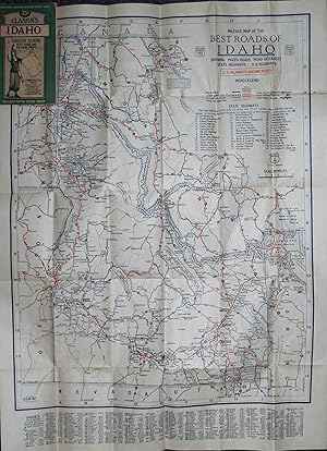
Clason's Guide Map of the State of Idaho
Published by Chicago & Denver c. 1930, Chicago & Denver, 1930
Seller: High Ridge Books, Inc. - ABAA, South Deerfield, MA, U.S.A.
Association Member: ABAA ESA ILAB SNEAB
Seller rating 5 out of 5 stars
Folding map in Clason's Idaho Green Guide. Very good condition, with light wear at edges and one short mended tear to the map. Includes 32 pp. text with place name index, lists of roads and railroads, descriptive information about the state, small uncolored map of Boise. The map is printed on both sides, with the general map on one side and a Mileage Map of the Best Roads of Idaho on the other.
-
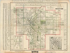
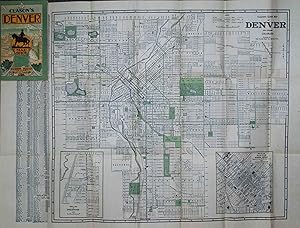
Clason's Guide Map of Denver and Suburbs - Detailed city plan of Denver from the early 20th century.
Published by c. 1908, 1908
Seller: Curtis Wright Maps, Berwyn, IL, U.S.A.
Seller rating 5 out of 5 stars
Condition: Very Good. "This fascinating city plan and street index of Denver, Colorado was issued locally by the Clason Map Company around 1908, based on the buildings listed. It shows an orderly street grid with transit routes and boulevards given extra attention, as outlined in the accompanying legend at the top of the sheet. The key notes 'street car tracks not used,' alluding to the slow but inexorable shift in public transportation. The map includes two insets; the lower right shows a large scale view of the downtown area, with individual buildings labeled between Union Depot and the State Capitol. The second inset, lower left, shows the suburban municipality of Englewood immediately south of Denver. Published by the city's Chamber of Commerce, the map also encourages its audience to visit the surrounding area, through 'Denver the Gateway to 12 National Parks and 32 National Monuments." Sheet Width (in) 27.8 Sheet Height (in) 20.9 Condition Description Previously folded into 12 segments, with moderate wear and creasing along fold lines. Some areas also feature faint discoloration. There is blue crayon markings within the image, and the outer margins are worn and soiled, with several small tears repaired on verso. Remains in good, presentable condition overall.
-
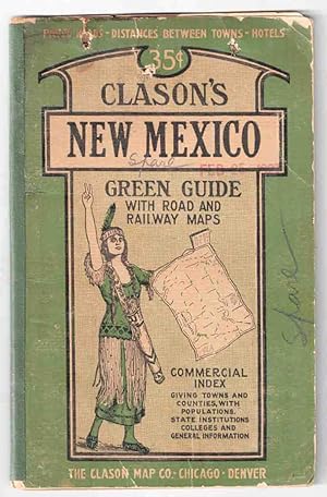
Clason's Guide Map of New Mexico
Published by Chicago & Denver c.1927, Chicago & Denver, 1927
Seller: High Ridge Books, Inc. - ABAA, South Deerfield, MA, U.S.A.
Association Member: ABAA ESA ILAB SNEAB
Seller rating 5 out of 5 stars
Folding map in Clason's New Mexico Green Guide. Good condition only, covers worn, old stains in top margin of text and along some folds of map. Three small punctures through the front cover, one through the text. Splits along maps folds mended. Includes 32 pp. text with place name index, lists of roads and railroads, descriptive information about the state, small uncolored maps of Albuquerque and Santa Fe business districts. Map is brightly colored, with roads, railroads, reservations and national forests highlighted. Dated from population figure in text. The date of the map is not stated, but it is clearly after 1921 due to the presence of Harding and Catron Counties.
-

Clason's Guide Map of New Mexico
Published by Chicago & Denver c. 1920, Chicago & Denver, 1920
Seller: High Ridge Books, Inc. - ABAA, South Deerfield, MA, U.S.A.
Association Member: ABAA ESA ILAB SNEAB
Seller rating 5 out of 5 stars
Folding map in Clason's New Mexico Green Guide. fine condition, with light wear at edges and short tear at top of spine. Includes 28 pp. text with place name index, lists of roads and railroads, descriptive information about the state, small uncolored maps of Albuquerque and Santa Fe business districts. Map is brightly colored, with roads, railroads, reservations and national forests highlighted. Dated from population figure in text. Also dated from the absence of Harding and Catron Counties, both of which were established in early 1921.
-
Clason's Chicago Street and Transportation Guide - "The quickest wayfrom where you are to where you want to go!"
Published by c. 1920, 1920
Seller: Curtis Wright Maps, Berwyn, IL, U.S.A.
Seller rating 5 out of 5 stars
Condition: Very Good. "The detailed guidebook to Chicago was published locally around 1920 by the Clason Map Company. Its 96 pages include a wealth of contemporary information about the Second City and provides a comprehensive street index, information on accommodations, transportation details, and a number of single-page plans covering the various suburbs. Accompanying the guidebook is a large folding map of the city, with its outlines in red and the forest preserves, parks, boulevards, and cemeteries highlighted in green. The Loop, Cubs & White Sox Ballparks, and the Union Stockyards, evidently four of the city's most vital economic areas, are also colored in red. Transportation routes are noted in great detail; including street names, railroads, and waterways. Various locations of interest are individually labeled, such as Grant Park Stadium (under construction), the Municipal Pier, and several buildings within the inset map of the Loop (center left). Surrounding the image is a border identifying Chicago's new street numbering system which was officially implemented about a decade prior to publication. Further information on the grid is available in the upper left. Dated using the presence of the Michigan Avenue Bridge (1920) and the absence of the Chicago Theater (opened in 1921). Source" Sheet Width (in) See Description Sheet Height (in) See Description Condition Description "96 pp. guidebook, approximately 4.25" x 7.5", with stapled binding and illustrated paper covers. Wrappers are heavily soiled, but intact, and the contents are in good shape save for some light spotting and creased corners. Includes a fold-out map affixed to the inside of the back cover. Map measures approximately 24.75" x 33.9" and has a 6" tear in the upper left where adhered to the guidebook. Otherwise lightly creased, a few small edge tears, and slightly faded color. Good to very good overall.".
-
Clason's War Map of the Western Front.
Published by Denver Colorado The Company, 1918, 1918
Seller: Franklin Gilliam :: Rare Books, A.B.A.A., Charlottesville, VA, U.S.A.
Seller rating 5 out of 5 stars
Single sheet, printed on one side only, 29 x 22 1/2 inches, folded to 5 3/4 x 3 1/2 inches. Printed gray stiff wrappers, front pictorial. The various advances by he allies on the Western Front are superimposed in red on the map, the latest being that of September 4, 1918.
-
Mileage Map of the Best Roads of Florida - A pair of early road maps closely associated with the early history of the Daytona Beach and Road Course.
Published by c. 1925, 1925
Seller: Curtis Wright Maps, Berwyn, IL, U.S.A.
Seller rating 5 out of 5 stars
Condition: Very Good. "The Clason Map Company was a pioneer of early road maps and atlases, and published this map of Florida originally around 1925. It shows numbered state highways in operation, as well as the pole markings for nine separate National Trails and "other posted roads." These routes, and their accompanying signage, were generally maintained by private groups, municipalities or trade organizations until the designation of the national numbered highway system in 1926. An inset map in the lower left shows the western end of the state, and a red callout in the upper right highlights the Daytona Highlands, "Florida's suburb of hills and lakes." This particular example of the road map must have been issued by a real estate agent or the local chamber of commerce affiliated with Daytona Beach, as the brown paper covers also praise the oceanside city. Furthermore, this copy also came with a smaller, large scale map of Daytona Beach dated to the mid 1930's. It shows the Florida East Coast Railway traveling up the coast adjacent to the Dixie Highway and labels numerous subdivisions and additions in the area. Of particular interest is the photograph on the verso, which shows the world famous Daytona Beach and road course. Text below the image promotes "staged auto speed classics during the coming winter season" organized by local speed demon and land speed record holder Sig Haugdahl. Though the venture, which took place in early 1936, ultimately lost the city money, the publicity and association with automobile racing would forever cement Daytona Beach on the map." Sheet Width (in) 12.4 Sheet Height (in) 16.4 Condition Description The map folds into 20 panels affixed to the center of tri-fold paper covers. Creasing along fold lines and moderate offsetting present in several areas. One spot of soiling on the front cover, but otherwise it is clean and intact. The accompanying map of Daytona Beach is worn along fold lines and has a few pinholes.

![Seller image for Clason's Midget Map of Kansas [1918] for sale by Live Oak Booksellers](https://pictures.abebooks.com/inventory/md/md30455518925.jpg)


![Seller image for City and Harbor of Los Angeles [panel title] for sale by James Arsenault & Company, ABAA](https://pictures.abebooks.com/inventory/md/md31946818032.jpg)


![Seller image for Clason's Montana green guide : state and city maps, auto road logs, railroads : commercial index of towns giving hotels, industries, altitudes, population, etc 1921 [Leather Bound] for sale by Gyan Books Pvt. Ltd.](https://pictures.abebooks.com/inventory/md/md31222094660.jpg)