Order Total (1 Item Items):
Shipping Destination:

Brue a H (28 results)
Feedback
Skip to main search results
Search filters
Product Type
- All Product Types
- Books (13)
- Magazines & Periodicals (No further results match this refinement)
- Comics (No further results match this refinement)
- Sheet Music (No further results match this refinement)
- Art, Prints & Posters (No further results match this refinement)
- Photographs (No further results match this refinement)
- Maps (15)
- Manuscripts & Paper Collectibles (No further results match this refinement)
Condition
Binding
Collectible Attributes
- First Edition (No further results match this refinement)
- Signed (No further results match this refinement)
- Dust Jacket (No further results match this refinement)
- Seller-Supplied Images (20)
- Not Print on Demand (28)
Language (3)
Free Shipping
- Free Shipping to United Kingdom (No further results match this refinement)
Seller Location
Seller Rating
-

Background to the English Renaissance: Introductiry Lectures
Seller: Hay-on-Wye Booksellers, Hay-on-Wye, HEREF, United Kingdom
Seller rating 5 out of 5 stars

Condition: Very Good. Fading and scuffs to cover. Tanning to textblock. Contents very good.
-

Maike Kang Nile Bulu Yi: Economics(Chinese Edition)
Published by Chinese People s University Press Pub. Date :2008-, 1991
ISBN 10: 7300091601 ISBN 13: 9787300091600
Language: English
� 69.66
Convert currency� 11.09 shipping from China to United KingdomQuantity: 3 available
Add to basketSoft cover. Condition: New. Language:Chinese.Author:SI TAN LI L BU LU YI (Stanley L. Brue) KAN BEI ER R MAI KE KANG NAI ER (Campbell R. McConnell) LI SHAO RONG LI SHU LING YI.Binding:Soft cover.Publisher:Chinese People s University Press Pub. Date :2008-.
-
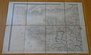
Carte Physique et Routiere de la France, de la Suisse et de l'Italie Septentrionale, indiquam aussi les Relais, leurs distances intermediaires, les Bureaux de Postes aux Lettres et les Lieux d'Etape du Royaume de France.
Published by J. Goujon, Paris, 1826
Language: French
� 134.13
Convert currency� 13.02 shipping from Germany to United KingdomQuantity: 1 available
Add to basketLeinen. Condition: Guter Zustand. Dust Jacket Condition: Kein Schutzumschlag. Carte auf Leinen aufgezogen in 3 X 7 Segmenten gefaltet in einem Schuber; 1820, revue corrigee et augmentee en 1826; saubere Karte, keine Einrisse, keine Stockflecken; Schutzkarton mit Einrissen und Papierverlust, Schuber berieben; 65,5 cm x 98 cm.
-
Carte Physique Et Routiere de La France,de La Suisse et de L,Italie
Published by Chez J.Goujon et J.Andriveau,Paris, 1830
Seller: Springwell Books, Gloucestershire, United Kingdom
Seller rating 5 out of 5 stars
Map
No Binding. Condition: Very Good. folding map dissected onto linen in 36 panels,engraved area 93 x 61cm.,original light colouring,paper just a little toned,otherwise a very good,bright and clean copy,folding down into a fold around case,and then into the original,slightly rubbed slipcase.
-
CARTE TOPOGRAPHIQUE DES ENVIRONS DE PARIS, NOUVELLE EDITION DRESS�E D'APR�S CELLE DES CHASSES PAR M. A.H. BRU�, d'apr�s les travaux de la nouvelle carte de France,
Published by Chez Andriveau, �dition nouvelle, 1867, 1867
� 152.02
Convert currency� 12.15 shipping from France to United KingdomQuantity: 1 available
Add to basketUne carte entoil�e de 100 sur 72 cm, pli�e sous couverture percaline verte editeur (12x 18, 5 cm, une fois repli�e). Dans l'angle sup�rieur gauche on trouve une sorte de cartouche l�g�rement orn� o� s'inscrit le texte recopi� plus haut dans le titre.La carte est �videmment entoil�e et l'entoilage est en ETAT TRES SATISFAISANT.
-
� 250.38
Convert currency� 5.21 shipping from France to United KingdomQuantity: 1 available
Add to basketCouverture souple. Condition: Bon. Quatre cartes d�pliantes toil�es, Chez Goujon et Andriveau, �dition Picquet, 1830, format 88*60 cm pour chacune des cartes, soit une dimension totale de 176*120 cm (environ). Un peu piqu�es, bon �tat g�n�ral. Colori�es (figure l'inscription : "Exemplaire ayant servi aux enfants de Louis Philippe et colori� par eux".). Bel ensemble. Photographies suppl�mentaires disponibles sur demande. Poids total 700 g. Envoi Colissimo. Frais d'envoi 7,50 euros sur la France, 14,85 UE et Suisse, entre 19,35 et 26,30 euros pour le reste du monde, � sp�cifier selon zone. Possibilit� de remise en mains propres sur Paris, n'h�sitez pas � me contacter avant de passer commande.
-
Italien. Kupferstich mit Grenzkolorierung. Carte Routiere de l Italie indiquant les Divisions politiques de ses divers etats.Dressee en 1820. ( Karte von Italien mit Sizilien, Korsika, Sardinien, Malta u. Gozo. Einschaltkarte von Teilen Frankreichs ) 1824
Published by Verlag C. Simmoneau., Paris., 1824
Seller: Buecherstube Eilert, Versandantiquariat, Dresden, DD, Germany
Seller rating 5 out of 5 stars
� 312.97
Convert currency� 26.04 shipping from Germany to United KingdomQuantity: 1 available
Add to basket84 x 64 grenzkolorierter Kupferstich Karte, 16 Segmente 21 x16 cm auf Leinwand aufgezogen. Gefaltet auf dieses Mass, �u�erstes Deckelsegment mit Innenstadtplan von Berlin montiert, ( wohl wo diese Karte zu kaufen war ) in zweifacher marmorierter Papier Mappe, innere mit Gebrausspuren. Karte in au�erordentlich sehr gutem Zustand. 22, K4 Sprache: fr.
-
Carte phisique administrative et routiere de la France indiquant aussi la navigation int�rieure du royaume
Published by J. Goujon, Parigi, 1818
Seller: Il Bulino Antiche Stampe srl, Milano, MI, Italy
Seller rating 5 out of 5 stars
� 625.95
Convert currency� 17.36 shipping from Italy to United KingdomQuantity: 1 available
Add to basketCarte phisique administrative et routiere de la France indiquant aussi la navigation int�rieure du royaume, Parigi, J. Goujon, 1818. Cm 116x166. . Custodia in cartone con carta marmorizzata azzurra. Etichetta manoscritta con titolo, etichetta editoriale con indirizzo del venditore: a Marseille chez la Veuve Buisson, n�e Monier M.de de Cartes Geographiques et Marines Globes Spheres, Quai de l'Isle du Cul-de-Boeuf, n 7. Ottantaquattro parti intelate e divise in due fogli. Geografo di S A R Monsieur Comte d'Artois. 750.
-
� 72.37
Convert currency� 6.66 shipping from U.S.A. to United KingdomQuantity: 1 available
Add to basket14 1/4 x 20 inches. Condition: Very good. A beautifully engraved map of the northern Nile area of Egypt. The Nile Delta region is filled with great detail. Hatchers are used to delineate the Valley of the Nile. A very nice presentation from Sidon in the north to Taphis in the south.
-

� 76.18
Convert currency� 6.66 shipping from U.S.A. to United KingdomQuantity: 1 available
Add to basket20 x 14 1/4 inches. A quite attractive artifact of the mapmakers art from the first quarter of the 19th century. From Russia d'Europe in the west to Amerique Septent in the east the map is finely engraved with the then known places. The Northeast Passage is promoted by showing an open glaciated sea in the north. In the south the map includes some territory of the Chinese. There is an inset map showing Regions Polaris. It shows Greenland and North America. Good with minor marginal tears expertly repaired.
-
General Karte der Schweiz eingetheilt in 22 Cantone
Published by Wien, Artaria und Comp. 1845., 1845
Seller: Antiquariat Burgverlag, Wien, Austria
Association Member: ILAB VDA VDAO
Seller rating 5 out of 5 stars
� 76.01
Convert currency� 16.50 shipping from Austria to United KingdomQuantity: 1 available
Add to basketAltkolorierte Kupferstichkarte. 47, 2 x 63 cm (Blattgr.); 40 x 52, 5 cm (Plattengr.). Mit mittiger vertikaler Faltspur. Oberer Rand mit 2 kl. Knitterstellen, sonst gut erhalten. vgl. Espenhorst 57 - Karte der Schweiz mit farbiger Hervorhebung der einzelnen Kantone mit kl. Legende in der oberen rechten Ecke. Wohl aus einem von Franz Fried bei Artaria �berarbeiteten Atlas, der erstmals 1822/25 erschienen ist und vielfach auf den Karten von Adrien Hubert Bru� (1786.1832) beruht. Gewicht in Gramm: 500.
-
![Seller image for [Gaule]. Carte G�n�rale des Gaules. for sale by Robert Frew Ltd. ABA ILAB](https://pictures.abebooks.com/inventory/md/md32076219303.jpg)
[Gaule]. Carte G�n�rale des Gaules.
Published by ParisChez l'Auteur Rue des Ma�ons Sorbonne Ao�t ., 1821
Seller: Robert Frew Ltd. ABA ILAB, London, United Kingdom
Association Member: ABA ILAB PBFA
Seller rating 4 out of 5 stars

Map
Original double-page engraved map of the Ancient France (53 x 68 cm overall) with original outline colour and calligraphic title. Authorial blindstamp to upper right corner. Some faint isolated marginal spotting not affecting map, generally a very good copy. Andre Hubert Bru� (1786-1832) was a French geographer and cartographer. Born in Paris, he served in the French Navy, joining the Baudin expedition to the Pacific (1800-1804). After his sea service, Bru� applied his navigation and charting skills to creating finely-crafted maps, which were renowned for their crisp engraving and accuracy. He drew directly on the copper of the plate, creating what he called encyprotypes. He is best known for the Atlas universal de g�ographie physique, politique, ancienne et moderne. As is usually the case with Adrian Hubert Bru�'s maps, the composition is extremely well done. Both the topography and infrastructure have been represented with an impressive level of accuracy. Cities, towns, and villages are clearly marked, as are roads, rivers, and other routes.
-

Antique Map of Asia by A.H. Bru� (1820)
Published by A.H. Bru�, 1820
Seller: Bartele Gallery - The Netherlands, Langweer, FRL, Netherlands
Seller rating 5 out of 5 stars
Map
� 97.92
Convert currency� 13.02 shipping from Netherlands to United KingdomQuantity: 1 available
Add to basketNo Binding. Condition: Good. Antique map titled 'Carte de l'Asie'. Published in the 'Atlas Universel', 1820. Stamp near title. Tear along folding line, please study image carefully. Overall size 69 x 52.5 cm. Image size: 51 x 36 cm.
-
![Seller image for [The Netherlands]. Carte du Royaume des Pays-Bas. for sale by Robert Frew Ltd. ABA ILAB](https://pictures.abebooks.com/inventory/md/md32076211451.jpg)
[The Netherlands]. Carte du Royaume des Pays-Bas.
Published by ParisChez l'Auteur Rue des Ma�ons Sorbonne Mai ., 1822
Seller: Robert Frew Ltd. ABA ILAB, London, United Kingdom
Association Member: ABA ILAB PBFA
Seller rating 4 out of 5 stars
Map
Original double-page engraved map of the Netherlands (68 x 53 cm overall) with original outline colour and calligraphic title. Authorial blindstamp to bottom left corner. Generally an excellent copy. Andre Hubert Bru� (1786-1832) was a French geographer and cartographer. Born in Paris, he served in the French Navy, joining the Baudin expedition to the Pacific (1800-1804). After his sea service, Bru� applied his navigation and charting skills to creating finely-crafted maps, which were renowned for their crisp engraving and accuracy. He drew directly on the copper of the plate, creating what he called encyprotypes. He is best known for the Atlas universal de g�ographie physique, politique, ancienne et moderne. As is usually the case with Adrian Hubert Bru�'s maps, the composition is extremely well done. Both the topography and infrastructure have been represented with an impressive level of accuracy. Cities, towns, and villages are clearly marked, as are roads, rivers, and other routes.
-
![Seller image for [The Austrian Empire]. Carte G�n�rale de l'Empire d'Autriche, du Roy[au]me. de Prusse de la Conf�d�ration Germanique et du Roy[au]me. de Pologne. for sale by Robert Frew Ltd. ABA ILAB](https://pictures.abebooks.com/inventory/md/md32076207775.jpg)
[The Austrian Empire]. Carte G�n�rale de l'Empire d'Autriche, du Roy[au]me. de Prusse de la Conf�d�ration Germanique et du Roy[au]me. de Pologne.
Published by ParisChez l'Auteur Rue des Ma�ons Sorbonne Novembre ., 1821
Seller: Robert Frew Ltd. ABA ILAB, London, United Kingdom
Association Member: ABA ILAB PBFA
Seller rating 4 out of 5 stars
Map
Original double-page engraved map of the Austrian Empire (53 x 68 cm overall) with original outline colour and calligraphic title. Authorial blindstamp to upper right corner. Some faint isolated marginal spotting not affecting map, generally a very good copy. Andre Hubert Bru� (1786-1832) was a French geographer and cartographer. Born in Paris, he served in the French Navy, joining the Baudin expedition to the Pacific (1800-1804). After his sea service, Bru� applied his navigation and charting skills to creating finely-crafted maps, which were renowned for their crisp engraving and accuracy. He drew directly on the copper of the plate, creating what he called encyprotypes. He is best known for the Atlas universal de g�ographie physique, politique, ancienne et moderne. As is usually the case with Adrian Hubert Bru�'s maps, the composition is extremely well done. Both the topography and infrastructure have been represented with an impressive level of accuracy. Cities, towns, and villages are clearly marked, as are roads, rivers, and other routes.
-

Carte Comparative de la France en Trente-Deux Gouvernemens (� l'�poque de 1789) et en Quatre-Vingt-Six D�partements.
Published by ParisChez l'Auteur Rue des Ma�ons Sorbonne Juin ., 1820
Seller: Robert Frew Ltd. ABA ILAB, London, United Kingdom
Association Member: ABA ILAB PBFA
Seller rating 4 out of 5 stars
Map
Original double-page engraved map of France (53 x 68 cm overall) with full original colour and calligraphic title. Authorial blindstamp to upper right corner. With an inset map of Corsica. Generally a very good copy. Andre Hubert Bru� (1786-1832) was a French geographer and cartographer. Born in Paris, he served in the French Navy, joining the Baudin expedition to the Pacific (1800-1804). After his sea service, Bru� applied his navigation and charting skills to creating finely-crafted maps, which were renowned for their crisp engraving and accuracy. He drew directly on the copper of the plate, creating what he called encyprotypes. He is best known for the Atlas universal de g�ographie physique, politique, ancienne et moderne. As is usually the case with Adrian Hubert Bru�'s maps, the composition is extremely well done. Both the topography and infrastructure have been represented with an impressive level of accuracy. Cities, towns, and villages are clearly marked, as are roads, rivers, and other routes.
-
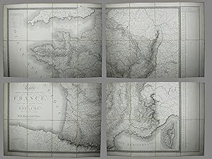
Carte physique, administrative et routi�re de la France, indiquant aussi la navigation int�rieure du Royaume; Par A.H. Bru�, g�ographe de S.A.R. Monsier Comte d'Artois. Janvier 1818, augment�e par l'auteur en juin 1818.
Published by A Paris, chez J. Goujon, 1818. 1818., 1818
Seller: Daniel Thierstein, Bern, Switzerland
Association Member: GIAQ ILAB VEBUKU
Seller rating 4 out of 5 stars
� 211.14
Convert currency� 16.50 shipping from Switzerland to United KingdomQuantity: 1 available
Add to basketIn 4 Karten. Blattgr�ssen: je ca. 58x80,5 cm. 4 Karten � 8 Segmenten, aufgezogen auf Leinwand. In Kartonschuber. Der Kartonschuber ohne Deckel. Sprache: n.
-
![Seller image for [Egypt]. Carte G�n�rale de l'�gypte et de l'Arabie P�tr�e. for sale by Robert Frew Ltd. ABA ILAB](https://pictures.abebooks.com/inventory/md/md32076215381.jpg)
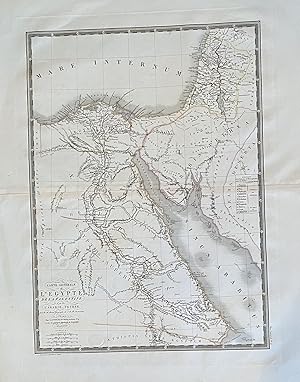
[Egypt]. Carte G�n�rale de l'�gypte et de l'Arabie P�tr�e.
Published by ParisChez l'Auteur Rue des Ma�ons Sorbonne April ., 1822
Seller: Robert Frew Ltd. ABA ILAB, London, United Kingdom
Association Member: ABA ILAB PBFA
Seller rating 4 out of 5 stars
Map
Original double-page engraved map of Egypt and part of Arabia Petraea (68 x 53 cm overall) with original outline colour and calligraphic title. Some light marginal toning and spotting, generally a very good example. Andre Hubert Bru� (1786-1832) was a French geographer and cartographer. Born in Paris, he served in the French Navy, joining the Baudin expedition to the Pacific (1800-1804). After his sea service, Bru� applied his navigation and charting skills to creating finely-crafted maps, which were renowned for their crisp engraving and accuracy. He drew directly on the copper of the plate, creating what he called encyprotypes. He is best known for the Atlas universal de g�ographie physique, politique, ancienne et moderne. As is usually the case with Adrian Hubert Bru�'s maps, the composition is extremely well done. Both the topography and infrastructure have been represented with an impressive level of accuracy. Cities, towns, and villages are clearly marked, as are roads, rivers, and other routes.
-
Carte Physique et Routi�re de la France, de la Suisse et de l'Italie Septentrionale, indiquam aussi les Relais, leurs distances intermediaires, les Bureaux de Poste, aux Lettres et les Lieux d'Etape.
Published by Chez Andriveau-Goujon,, Paris,, 1840
Seller: Llibreria Antiqu�ria Delstres, Canet de Mar, Barcelona, B, Spain
Seller rating 5 out of 5 stars
� 223.55
Convert currency� 13.89 shipping from Spain to United KingdomQuantity: 1 available
Add to basketUno de los primeros mapas de rutas de postas y albergues para pernoctar durante los viajes por Francia, Italia y Suiza. Mapa montado en tela de la �poca y en porciones de 21x14 cm. Plegado con carpeta y estuche original. Demarcaciones en color de la �poca. Buen estado de conservaci�n. 65x 99 cm.
-

Carte de L'Afrique
Published by Paris, 1820
Seller: Alexandre Antique Prints, Maps & Books, Toronto, ON, Canada
Seller rating 5 out of 5 stars
Map
� 285.66
Convert currency� 6.29 shipping from Canada to United KingdomQuantity: 1 available
Add to basketCondition: Excellent. A blind stamp saying " Carte Encyprotipe" on the lower left hand corner next to the title, Size : 400x550 (mm), 15.75x21.625 (Inches), Original Outline Coloring.
-
Carte Routiere de l'Italie indiquant les divisions politiques des divers Etats
Published by Italia
Seller: Sergio Trippini, Gavirate, VA, Italy
Seller rating 5 out of 5 stars
� 268.26
Convert currency� 26.04 shipping from Italy to United KingdomQuantity: 1 available
Add to basketCarta geografica dell'Italia montata su tela a stacchi. Questa carta, come dichiarato nel titolo, evidenzia in modo dettagliato la rete stradale mentre � sommaria dal punto di vista orografico. Nell'angolo in basso a destra vi sono le indicazioni delle scale grafiche e dei segni convenzionali utilizzati per i centri abitati e le varie tipologie di strade, con una nota riguardante la distanza tra due luoghi di posta. In calce sono riportati i vari rivenditori, stranieri ed italiani, dove � possibile acquistare la carta. I confini sono acquerellati all'epoca. La carta � conservata nel suo astuccio coevo decorato con impressioni in oro a secco.
-
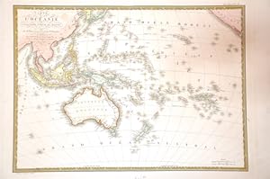
Carte de L'Oceanie ou Cinquieme Partie Du Monde
Published by Paris, 1820
Seller: Alexandre Antique Prints, Maps & Books, Toronto, ON, Canada
Seller rating 5 out of 5 stars
Map
� 361.84
Convert currency� 6.29 shipping from Canada to United KingdomQuantity: 1 available
Add to basketSize : 515x365 (mm), 20.28x14.37 (Inches), Hand Colored Very Good; backed on acid free tissue paper for long term preservation.
-
Carte Physique, Routi�re et Politique D'Europe. Indiquant les limites des �tats d'apr�s les derniers trait�s de paix. Revue et Argment�e par Ch. Piquet, G�ographe du Roi.
Published by Chez Ch Piquet propri�taire des Cartes et Atlas de Bru�., 1844
Seller: Libreria Antiquaria Pontremoli SRL, Milano, MI, Italy
Seller rating 4 out of 5 stars
� 357.68
Convert currency� 13.02 shipping from Italy to United KingdomQuantity: 1 available
Add to basketParis, Chez Ch Piquet propri�taire des Cartes et Atlas de Bru�. 1844, Paris, Chez Ch. Piquet propri�taire des Cartes et Atlas de Bru�. 1844. Grande carta dell'Europa di cm 124x180, colorata d'epoca; divisa in quattro parti telate, ogni parte � composta da 8 fogli.
-
Carte de l'Oc�anic ou Cinquieme partie du monde
Published by Artist: Bru� AH; issued in: Paris; dated:, 1830
Seller: Antique Sommer& Sapunaru KG, M�nchen, Germany
Seller rating 3 out of 5 stars

� 563.35
Convert currency� 30.39 shipping from Germany to United KingdomQuantity: 1 available
Add to basketTechnic: Copper print, colorit: coloredcondition: Very good, size (in cm): 36 x 51 cm; - Map of the Pacific Ocean with Southeast Asia and Australia.
-

CARTE DE L'ASIE par A.H Brue, Geographe. S.A.R. Monsieur, Comte D'Artois .(1820)
Publication Date: 1820
Seller: Tmecca Inc., Seoul, Korea, Republic of
Association Member: ILAB
Seller rating 5 out of 5 stars
Map
� 380.89
Convert currency� 14.78 shipping from Korea, Republic of to United KingdomQuantity: 1 available
Add to basketNo Binding. Condition: As New. 65 x 49 cm.
-
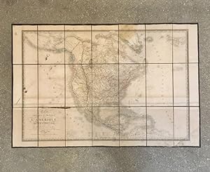
� 407.76
Convert currency� 13.02 shipping from France to United KingdomQuantity: 1 available
Add to basketParis, J. Goujon et J. Andriveau, 1833. 64,5 x 98,5 cm (chemise et �tui d�fra�chis, taches et rousseurs, deux trous sans atteinte � un pays). Carte de l'Am�rique du Nord rehauss�e de couleurs pour noter les possessions de divers pays dans cette r�gion du monde. Imprim�e sur papier et encoll�e sur 1 pan toile de toile brune. Une premi�re version avait paru en 1821. Bru� �tait un explorateur et cartographe de renom � son �poque. Voir photographie(s) / See picture(s) * Membre du SLAM et de la LILA / ILAB Member. La librairie est ouverte du lundi au vendredi de 14h � 19h. Merci de nous pr�venir avant de passer,certains de nos livres �tant entrepos�s dans une r�serve.
-

Carte Physique et Politique L'ASIE
Publication Date: 1829
Seller: Tmecca Inc., Seoul, Korea, Republic of
Association Member: ILAB
Seller rating 5 out of 5 stars
Map
� 457.06
Convert currency� 14.78 shipping from Korea, Republic of to United KingdomQuantity: 1 available
Add to basketNo Binding. Condition: As New. Detailed map of Asia prepared by Adrien-Hubert Bru�. The map has many manuscript annotations in red and brown ink. Several distances measured from St. Petersburg are added in "verstes", an obsolete Russian unit of length equivalent to about 1.067 kilometers (0.6629 miles).
-

CARTE DE L'ASIE par A.H Brue, Geographe. S.A.R. Monsieur, Comte D'Artois .(1820)
Publication Date: 1820
Seller: Tmecca Inc., Seoul, Korea, Republic of
Association Member: ILAB
Seller rating 5 out of 5 stars
Map
� 533.24
Convert currency� 14.78 shipping from Korea, Republic of to United KingdomQuantity: 1 available
Add to basketNo Binding. Condition: As New.