Order Total (1 Item Items):
Shipping Destination:

Bollmann Herman (2 results)
Skip to main search results
Search filters
Product Type
- All Product Types
- Books (2)
- Magazines & Periodicals (No further results match this refinement)
- Comics (No further results match this refinement)
- Sheet Music (No further results match this refinement)
- Art, Prints & Posters (No further results match this refinement)
- Photographs (No further results match this refinement)
- Maps (No further results match this refinement)
- Manuscripts & Paper Collectibles (No further results match this refinement)
Condition Learn more
- New (No further results match this refinement)
- As New, Fine or Near Fine (No further results match this refinement)
- Very Good or Good (No further results match this refinement)
- Fair or Poor (No further results match this refinement)
- As Described (2)
Binding
- All Bindings
- Hardcover (No further results match this refinement)
- Softcover (1)
Collectible Attributes
- First Edition (1)
- Signed (No further results match this refinement)
- Dust Jacket (No further results match this refinement)
- Seller-Supplied Images (2)
- Not Print on Demand (2)
Language (1)
Price
- Any Price
- Under � 20 (No further results match this refinement)
- � 20 to � 35 (No further results match this refinement)
- Over � 35
Free Shipping
- Free Shipping to U.S.A. (No further results match this refinement)
Seller Location
Seller Rating
-
New York Map Guide
Published by New York, New York, 1963
Seller: High Ridge Books, Inc. - ABAA, South Deerfield, MA, U.S.A.
Association Member: ABAA ESA ILAB SNEAB
Seller rating 5 out of 5 stars

First Edition
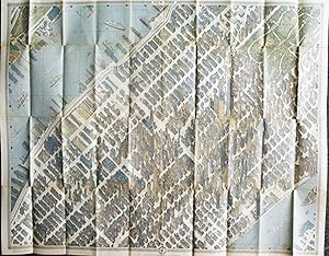
Folding map with original stiff pictorial wrappers. 48 pp. text. Very good condition, with light wear. First edition. One of the most monumental cartographic feats of the 20th century, Bollmann's bird's-eye view of central Manhattan has become an iconic image of New York in the age of Mad Men. This guide was sold at the New York World's Fair of 1964-65, with some of the descriptive text in French, German, Italian, Spanish and Japanese. There are ads for many storied Manhattan businesses, corporations, restaurants and hotels. Bollmann spent many years designing and executing this great work, which incorporated over 67,000 photos, including 17,000 from the air. For more information, see Augustyn and Cohen, Manhattan in Maps, p.152.
-
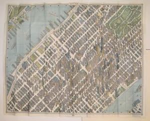
New York Map-Guide; Picture Map in Full Color, Street and Subway Maps
Published by Pictorial Maps, Inc, New York, 1963
Seller: Argosy Book Store, ABAA, ILAB, New York, NY, U.S.A.
Seller rating 5 out of 5 stars
Map. Colored lithograph. Image measures 32 1/2" x 41 1/2". Original visitors guide booklet measures 9 3/8" x 5". This pictorial map of New York City was included as part of the "Official World's Fair Edition" map and guide for the 1964 World's Fair. As the description printed on the inside of the outer sleeve notes, this bird's-eye-view of midtown Manhattan was "the first such map to be drawn of the city since 1866." With his design, Bollmann presented an innovative solution to the problem which New York City's tall skyscrapers and high concentration of buildings posed to mid-century mapmakers. After he and his staff used special cameras to take 67,000 individual photographs of the city, Bollmann used them to hand-draw this oblique "optically modified" axonometric projection that, as per the map's description, "gives full effect to the soaring beauty of the City." Highly accurate and detailed, the map is also labeled with important buildings and tourist destinations. On the reverse of the bird's-eye-view map is an aerial map of Manhattan and the surrounding boroughs that includes a street grid as well as subway lines. This version of the map came with an informational guide about the city, as well as important locations and their corresponding placement on the map. This copy is in its original, although opened, packaging and in good condition. Some splits along original folds and misfolds. The travel guide is also included. Rust stains on cover and guide booklet from staples, map not affected. Hermann Bollmann (1911-1971) was a German cartographer who brought his training as a graphic artist to bear on the German tradition of Vogelschaukarten (bird's-eye-view maps). His masterpiece map of New York attests to the remarkable quality both of his efforts and of the city that they took as their subject.