Order Total (1 Item Items):
Shipping Destination:

Bacon Ltd (39 results)
Feedback
Author:
bacon ltd
Refine with Advanced Search
Skip to main search results
Search filters
Product Type
- All Product Types
- Books (25)
- Magazines & Periodicals (No further results match this refinement)
- Comics (No further results match this refinement)
- Sheet Music (No further results match this refinement)
- Art, Prints & Posters (No further results match this refinement)
- Photographs (No further results match this refinement)
- Maps (14)
- Manuscripts & Paper Collectibles (No further results match this refinement)
Condition Learn more
Binding
Collectible Attributes
- First Edition (7)
- Signed (No further results match this refinement)
- Dust Jacket (No further results match this refinement)
- Seller-Supplied Images (30)
- Not Print on Demand (35)
Language (2)
Free Shipping
Seller Location
Seller Rating
-
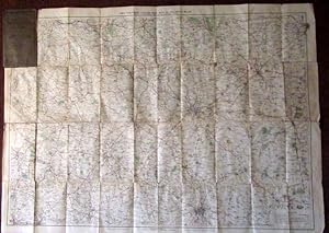
Bacon's Motoring and Cycling Road Map - Nottingham District - Half Inch Series.
Published by G.W. Bacon & Co. Ltd, United Kingdom, 1920
Seller: Winghale Books, South Kelsey, LINCS, United Kingdom
Seller rating 5 out of 5 stars

Soft cover. Condition: Read description. Size (folded) - 18 x 10 cms. Size (unfolded) - 90 x 65 cms. No date but probably early 20th Cent. Covers and rear of map stained - the stain mark is also around the edges of the front idex (a large browning type mark) - a few minor tears to map - see photo. Bacon's Motoring and Cycling Road Map - Nottingham District - Half Inch Series. - no date but probably 1920s/30s?).
-

Map. Condition: Good. Covers marked and worn with short tears to the edges, cloth backed map undated.
-
Bacon's Map of the Seat of War in North Sea, Belgium and Eastern France. Scale 18 miles to the inch.
Published by G. W. Bacon & Co. Ltd.
Language: English
Seller: Kerr & Sons Booksellers ABA, Cartmel, CMA, United Kingdom
Seller rating 5 out of 5 stars
Map First Edition
Soft cover. Condition: Very Good. 1st Edition. No date, presumed 1st thus. Folding map, cloth-backed. Measures: 82cm x 55cm approx. In card covers. Some rubbing and edge wear. A 'Very Good' copy.
-
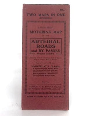
Reversible Large Print Motoring Map No.1: Arterial Roads and England & Wales: South Sheet
Published by G.W. Bacon & Co. Ltd, 1111
Seller: World of Rare Books, Goring-by-Sea, SXW, United Kingdom
Seller rating 5 out of 5 stars
Condition: Fair. No Edition Remarks. Unpaginated. Red paper cover. Colour illustrated reversible map. Number 1: Arterial Roads and By-Passes, 1 inch to 1.08 miles; and England & Wales, South Sheet, 8 miles to 1 inch. Map is lightly tanned with some mild rubbed marks overall. Scuffing along folds, with some heavier tanning. Some moderate tears to folds along edges. Paper cover has mild edge wear with scuffing to edges and creasing. Mild rubbing to surfaces with curling to corners.
-
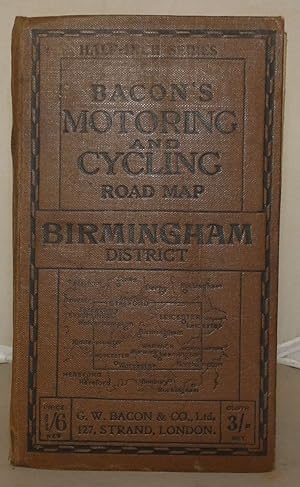
Bacon's Motoring and Cycling Road Map: Birmingham District
Published by G. W. Bacon & Co. Ltd., London, 1915
Seller: Besleys Books PBFA, Diss, United Kingdom
Association Member: PBFA
Seller rating 5 out of 5 stars
Hard Cover. Condition: Good. Hardback, folding map measuring 64cm x 89cm. Tear with small loss to 8pp Index of Towns. Map is in good order. A decent copy. (ar18).
-
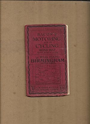
Bacon's motoring and cycling road map with route guide, 50 miles round Birmingham, Sheet8 of England. (Bacon's half-inch maps)
Published by G.W. Bacon & Co. Ltd
Seller: Gwyn Tudur Davies, Aberystwyth, United Kingdom
Seller rating 5 out of 5 stars
Map
Soft cover. Condition: Good. No Jacket. 1 folded col. map. Covers dulled and creased, some scuffing along folds of map o/w pretty good condition. No publication date [c191-?]. [Maps - Birmingham and district - England] r390 / m14101.
-
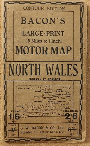
Bacon's Large-print (5 Miles to 1 Inch) Motor Map - North Wales (Sheet 2 of England) CONTOUR EDITION
Published by G W Bacon & Co Ltd, 1950
Map
Soft cover. Condition: Very Good. (SL#19).
-

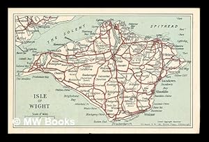
Bacon's Large Scale Map of the Isle of Wight
Published by W. & A.K. Johnston & G.W. Bacon Ltd, London and Edinburgh, 1955
Card Covers. Condition: Good Plus. Dust Jacket Condition: None. Fold-out map of the Isle of Wight with large index to place names. Map fully coloured (roads in red, woods and parks in green) on a scale of 1 inch to 1 mile. Yellow and green card covers 6.5 x 3.75 inches. Map in 21 sections of the same size. Originally published at 2/- (two shillings).
-
Post card showing a map of the Isle of Wight
Published by Edinburgh: G. W. Bacon & Co. Ltd.
First Edition
� 9.76
Convert currency� 9.48 shipping from Ireland to United KingdomQuantity: 1 available
Add to basketFirst Edition. One postcard in near fine condition and printed on stiff card paper. Remains well preserved overall; bright and clean. No inscription on the back of the postcard. Physical description; 1 postcard. Notes; No clear date given. Subjects; Isle of Wight. Maps. Postcards. 1 Kg.
-

My Second Atlas: 64 pages in colour containing 61 maps and insets: 190 illustrations with questions: index to place-names
Published by Edinburgh & London: W. & A. K. Johnston & G. W. Bacon Ltd., 1961
� 11.55
Convert currency� 9.48 shipping from Ireland to United KingdomQuantity: 1 available
Add to basketEnlarged Edition. Good copy bound in quarter cloth over decorated paper boards. So slight wear and tear as with age. Remains well preserved overall; bright and clean. Includes previous owner's inscriptions. Physical description; 64 pages. Notes; No clear publication date given. Subjects; Atlas. Children's Atlas. 1 Kg.
-
Bacon's New Survey Map of South Scotland including Counties of Dumbarton, Stirling. (etc) Showing Burghs, Parishes, Railways, Roads, Elevations & Distances.
Published by Manchester: G W Bacon c, 1900
Seller: David Ford Books PBFA, Cley-next-the-Sea, United Kingdom
Association Member: PBFA
Seller rating 5 out of 5 stars
Map
Condition: very good. Undated but from style and contents probably c.1900. HB. Purple cloth covers, lettered in gilt to spine and front, protecting large coloured folding map printed on paper laid onto linen, with marbled paper front and back once folded. Folds out to 24 sections. Scale of 3 miles to one inch. Folded size: 24.5 x 21 cm, opening out to 95 x 120 cm. Attractively printed in various colours, (pink, yellow, light orange and green), with a panel devoted to geology map, as well as text panels at sides for Index-Gazetteer. Good condition overall: the map is very good, bright and clean, with slight browning to margins, and the folds are clean and sturdy; there are some light marks to back of linen. The cloth covers are fair only as spine panel is largely lost but the front is very good and with bright gilt of title; creases to back. Other Bacon maps of various counties published at same time in same format available.
-

Variety Season: Souvenir Theatre Programme at the London Palladium, Oxford Circus, London
Published by Performance Programme Dated July 30th circa . 1947., 1947
Seller: Little Stour Books PBFA Member, Canterbury, United Kingdom
Association Member: PBFA
Seller rating 5 out of 5 stars
Original stapled colour illustrated souvenir theatre programme 8�'' x 5�''. Contains 12 printed pages of text, advertisements and photographs. In Very Good condition. Member of the P.B.F.A. THEATRE PROGRAMMES.
-
Bacon's Midget Map of Central & West London with Street Index and Visitor's Guide
Published by G.W. Bacon & Co. Ltd., Edinburgh
Language: English
Map
� 30.39
Convert currency� 18.44 shipping from Canada to United KingdomQuantity: 1 available
Add to basketSoft cover. Condition: Very Good Plus. Dust Jacket Condition: No DJ. No date stated: map displays "Copyright 1/52". Cardboard covers rubbed along edges and sides of spine, small tear (1/8 inch) on front top edge, corners bowed and creased. Map firmly attached. Overall, very good plus. Map has 3 pinpoint brown spots on underside, map itself is bright and clean.
-
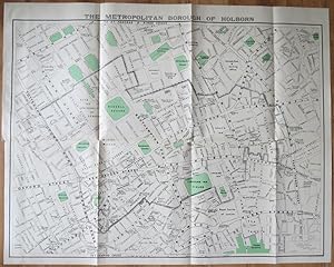
The Metropolitan Borough of Holborn.
Published by , 1939, 1939
Seller: Pennymead Books PBFA, Knaresborough, United Kingdom
Association Member: PBFA
Seller rating 4 out of 5 stars

Lithograph, coloured. Scale 1: 2500. Large folding map in fine condition. 39 x 31" Drawn by J.E. Parr Borough Engineer and Surveyor.
-
Francis Bacon. Recent Paintings. March - April 1967.
Seller: Frans Melk Antiquariaat, HILVERSUM, Netherlands
Seller rating 5 out of 5 stars
� 13.37
Convert currency� 16.01 shipping from Netherlands to United KingdomQuantity: 1 available
Add to basketExh. cat. London (Marlborough Fine Art Ltd.) 1967; 86 pp.; exhibition catalogue with a text in French and English by Michel Leiris, excerpts from interviews by David Sylvester and b/w and colour illustrations of which two fold-outs; softcover; transparant wrapper very tight around cover. [Art / international artist [Buitenlandse Kunstenaars] ].
-
Bacon's Motoring and Cycling Road Map England & Wales.
Published by G. W. Bacon & Co., Ltd., London, 1930
Seller: Jeffrey H. Marks, Rare Books, ABAA, Rochester, NY, U.S.A.
Seller rating 5 out of 5 stars
� 15.19
Convert currency� 26.55 shipping from U.S.A. to United KingdomQuantity: 1 available
Add to basketTinted map, about 28 x 23 inches, backed with linen and folded into 12mo portfolio as issued. publisher's blue lettered cloth. Light use to the cloth portfolio. Index on pastedown.
-

Bacon's Cycling Road-Map of England: Sheet No. 6 - Fifty Miles Around London
Published by G. W. Bacon & Co. Ltd., London
Seller: Kerr & Sons Booksellers ABA, Cartmel, CMA, United Kingdom
Seller rating 5 out of 5 stars
Map First Edition
Soft cover. Condition: Very Good. 1st Edition. No date, circa 1930's/40's. Map. Folding. Measures: 75cm x 60cm. Printed on cloth/linen. Coloured. Minor fraying to edges of map. Overall a bright example. Housed in red/maroon cloth pouch with gilt title. Advert for 'The Rover Bicycle' to rear. Some minor discolouration to pouch, corners slightly rubbed and bumped. Overall a Very Good copy.
-
Bacon's Large Scale Plan Of Woolwich, Including Plumstead, Eltham, Blackheath, Bromley, And Chislehurst In Scale Four Inches To A Mile. Large Folding Map.
Published by G. W. Bacon & Co. Ltd. 0, London.
Seller: James Hine, Ilminster, SOMER, United Kingdom
Association Member: PBFA
Seller rating 5 out of 5 stars
Soft cover. Condition: Very Good. No Jacket. Large folding coloured map in good condition. (illustrator). 5th or later Edition. Nd. c. 1910, edition not stated. 11 page alphabetical index to streets of Woolwich and adjacent districts to start. large folded coloured map in very good condition housed in red printed card cover rubbed around spine and edges, light marking, else very good copy. 11 p. Book.
-

Nightingales New Chart of the World
Published by G. W. Bacon & Co. Ltd., London
Language: English
Seller: Kerr & Sons Booksellers ABA, Cartmel, CMA, United Kingdom
Seller rating 5 out of 5 stars
Map First Edition
Hardcover. Condition: Very Good. 1st Edition. No date, circa 1920. Presumed 1st edition. Large folding colour map. In 18 sections/panels, measuring total: 83cm x 124cm approx. Cloth-backed. "Copyright J193" printed in lower corner. Bound in cloth-covered boards, small gilt title to cover. A 'Very Good' copy.
-
Bacon's Ruby Map London & Suburbs, Mounted 2/- on Cloth,
Published by London; G.W. Bacon Circa 1952, 1952
Seller: Virginia Martin, aka bookwitch, Concord, CA, U.S.A.
Seller rating 5 out of 5 stars
� 43.69
Convert currency� 25.82 shipping from U.S.A. to United KingdomQuantity: 1 available
Add to basketSoft cover. Condition: Very Good. No Jacket. 12 mo., green card covers, folding map inside of cardboard, cover scuffed else VG. map folded to small format [6 inches by 3.5] with 32pp index. Gives "strangers guide to London". Book.
-
25 Miles around Windsor
Published by London c.1905, London, 1905
Seller: High Ridge Books, Inc. - ABAA, South Deerfield, MA, U.S.A.
Association Member: ABAA ESA ILAB SNEAB
Seller rating 5 out of 5 stars
� 56.98
Convert currency� 25.82 shipping from U.S.A. to United KingdomQuantity: 1 available
Add to basketFolding map in stiff printed wrappers. 20 pp. text detailing distances along various bicycle routes. Shows the area from London in the east to Oxford at the northwest corner, Basingstoke, Aldershot and Guildford in the south. Defective, lacking most of an 8x15 cm. section at the bottom right, which would include the immediate area around Merstham. Otherwise, the map is in good condition with one repair of a split fold. Main roads and park areas are colored. The front wrapper reads "Bacon's Cycling Road-Map, 40 Miles about Windsor", though the map itself touts only 25 miles around Windsor. The back cover advertises Humber bicycles, touting their ownership by King Edward VII and other members of royal families.
-
Francis Bacon 1909-1992 Small Portrait Studies Loan Exhibition.
Published by London: 1995., 1995
Seller: D & E LAKE LTD. (ABAC/ILAB), Toronto, ON, Canada
Seller rating 3 out of 5 stars

� 50.60
Convert currency� 37.62 shipping from Canada to United KingdomQuantity: 1 available
Add to basketSoft cover. Condition: Fine. 4to. unpaginated. profusely in colour, some b/w. wrs. Exhibition catalogue.
-
Bacon's Large-Print Map of London and Suburbs with Guide Nd C1905 Linen-Backed Map
Published by G. W. Bacon & Co. , Ltd, London, 1905
Seller: Leaf and Stone Books, Toronto, ON, Canada
Association Member: ABAC ILAB IOBA
Seller rating 5 out of 5 stars
� 64.58
Convert currency� 25.82 shipping from Canada to United KingdomQuantity: 1 available
Add to basketHardcover. Condition: Good. Dust Jacket Condition: No Dust Jacket. [iv], 62 pp. Large folding linen-backed map. Folding red cloth covers with brilliant gilt to front. Inside is a double-page ad for Chas Baker & Co, followed by a double page map of central London (scale 9 inches to a mile) , an ad for Nevill's Turkish Baths ("pronounced to be the Finest In Europe") , then the Strangers' Guide to London, including horse cab fares, an ad for Brand's Savoury meat Lozenges "world-renowned as Life Sustainers", then a number of pages of places of interest, then more ads for John Piggott, Ltd. And the Tranter's Hotel. Across from the guide is the large folding map, cloth backed, measuring 38" x 28". The guide and map are in good condition, some wear and separating at the spine of the red cloth cover but holding together well, bit of rubbing at corners. . The guide and the map are in good condition with some normal age darkening but otherwise clean and unmarked. No date but the ad for Chas Baker has typeface and clothing consistent with the 1905-1910 period. ; 8vo 8" - 9" tall.
-

Yorkshire
Published by London c. 1895, London, 1895
Seller: High Ridge Books, Inc. - ABAA, South Deerfield, MA, U.S.A.
Association Member: ABAA ESA ILAB SNEAB
Seller rating 5 out of 5 stars
� 75.97
Convert currency� 25.82 shipping from U.S.A. to United KingdomQuantity: 1 available
Add to basketPocket map in original stiff illustrated wrappers. Fine condition. 36 pp. text, with descriptions of each of the towns in Yorkshire. The text is complete, but its signatures have been bound out of order. The map shows the major roads, identifying which are safest for bicycle riding and which have dangerous hills.
-
Bacon s Commercial and Industrial Map of Lancashire: Showing Railways, Roads, Elevations and Distances [Bacon s Excelsior Map of Lancashire]
Published by G. W. Bacon & Co. Ltd., Manchester ca. 1880, 1880
� 94.97
Convert currency� 24.33 shipping from U.S.A. to United KingdomQuantity: 1 available
Add to basketHardcover. Condition: Good. . . . . 8vo, hardcover, maroon cloth. Very large fold-out color map, backed on original linen. Vg condition. Binder faded, though intact, with backstrip possibly replaced. Map itself in very good condition, with no marking or rubbing. A fascinating contemporary look at 19th century England s industrial Midlands.
-

Bacon's Cycling Road-Map of Oxford and District
Published by London c. 1900, London, 1900
Seller: High Ridge Books, Inc. - ABAA, South Deerfield, MA, U.S.A.
Association Member: ABAA ESA ILAB SNEAB
Seller rating 5 out of 5 stars
� 94.97
Convert currency� 25.82 shipping from U.S.A. to United KingdomQuantity: 1 available
Add to basketUnbacked folding map in red cloth binding. 16 pp. text lists the bicycle routes. Very good condition, with general wear at extremities of binding. While the title and the routes listed describe an area in an around Oxford, the map shows a large area extending from Birmingham in the northwest to London in the southeast.
-
![Seller image for [WWI] War Map Issued By The Family Herald & Weekly Star for sale by RareNonFiction, IOBA](https://pictures.abebooks.com/inventory/md/md30881224048.jpg)
[WWI] War Map Issued By The Family Herald & Weekly Star
Published by The Family Herald and Weekly Star, Montreal, Canada, 1918
Seller: RareNonFiction, IOBA, Ladysmith, BC, Canada
Association Member: IOBA
Seller rating 5 out of 5 stars
Map First Edition
� 224.12
Convert currency� 25.81 shipping from Canada to United KingdomQuantity: 1 available
Add to basketMap. Condition: Good. First Edition. This copy bearing the ink stamp of F.R. Swanton of Davis Point, Manitoba. Frederick Swanton served in the 200th (Winnipeg) Battalion, Canadian Expeditionary Force (CEF) during WWI. Illustrated red card covers measure 8.25" x 5.5". Map folds out to 40" by 31". Undated but appears to be circa 1918. Issued as a supplement to Montreal publications The Family Herald and Weekly Star by permission G.W. Bacon & Co. Ltd., 127 Strand, London. Detailed black and white map of Europe presents the setting of World War I, presumably as a reference for Canadians following the progress of the war. Average wear. Several unobtrusive clear tape repairs. A sound vintage copy of this Canadian WWI memento with special noted provenance. Size: Double Elephant - over 25" - 50" tall.
-

Bacon's Library Map of the Environs of London.
Published by London G. W. Bacon & Co. Ltd. Norwich Street Fetter Lane EC4. c., 1931
Seller: Robert Frew Ltd. ABA ILAB, London, United Kingdom
Association Member: ABA ILAB PBFA
Seller rating 4 out of 5 stars
Map
Map dimensions 92 x 132 cm (excluding table to right margin), overall dimensions 100 x 149 cm. Large folding map of London and the surrounding regions covering the extents from Hoddesdon down to Reigate and Canvey Island across to Windsor. Bright original colour marking out the counties, boroughs, districts and parishes. The map divided into three mile squares numbered and lettered at the borders, the grid references corresponding to a large index of local authorities found at the right margin. Printed over four conjoined sheets, the whole divided into 28 sections and mounted on linen. Folds into orginal dark green cloth slipcase, gilt lettered to the upper board. Marbled paper to folded end sections on linen verso. The slipcase slightly worn at extremities, one of the lower joints cracked at the upper edge. The map in excellent condition. The Northern Line extension from Clapham Common to Morden (opened 1926) is marked on the map. Park Royal & Twyford Abbey Station on the District (now Piccadilly) Line is also shown, the station was closed in mid 1931. Stations along the eastern extent of the District Line between Barking and Upminster (re-opened 1932), such as Upney and Becontree, are not shown.
-
THE EASTERN CRISIS. BACON'S LARGE-SCALE MAP OF JAPAN, KOREA, CHINA, MANCHURIA. [Map title:] MAP OF CHINA, JAPAN AND KOREA.
Published by G. W. Bacon and Co. Ltd., 127, Strand. [c.1904], London, 1904
Seller: Marrins Bookshop, Folkestone, KENT, United Kingdom
Association Member: ABA ILAB PBFA
Seller rating 4 out of 5 stars
Coloured Folding Map. 30 x 21.5 inches. Paper map folded into red cloth cover, which has slight wear to extremities. splits along fold lines of map neatly repaired. This Map of 'The Eastern Crisis' probably dates to the start of the Russo-Japanese War of 1904-05 as it appears to show Russia still occupying Manchuria and Port Arthur and Korea still independent of Japan (until 1910). TOPOGRAPHY FAR EAST TOPOGRAPHY ASIA FOLDING MAPS 20TH CENTURY TOPOGRAPHY.
-
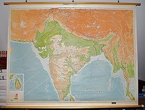
India, Pakistan, Ceylon and Burma: Physical-Political (Large Pull Down Map)
Published by Johnston and Bacon, Edinburgh, 1962
Seller: Sequitur Books, Boonsboro, MD, U.S.A.
Association Member: IOBA
Seller rating 5 out of 5 stars
Map
� 151.95
Convert currency� 24.34 shipping from U.S.A. to United KingdomQuantity: 1 available
Add to basketMaps. Condition: Good. 98 x 129 cm. Mounted on muslin and fitted with rods. Some creasing, general wear. Scale 1:3,000,000. Notes: Relief shown by gradient tints and spot heights; Depths shown by gradient tints; Includes inset of Ceylon. Bangladesh is not independent. Note: This is a large, heavy map. Additional postage will apply depending on delivery location.


![Seller image for THE EASTERN CRISIS. BACON'S LARGE-SCALE MAP OF JAPAN, KOREA, CHINA, MANCHURIA. [Map title:] MAP OF CHINA, JAPAN AND KOREA. for sale by Marrins Bookshop](https://pictures.abebooks.com/inventory/md/md22817594833.jpg)