Order Total (1 Item Items):
Shipping Destination:

Andriveau Goujon Eugene (93 results)
Feedback
Skip to main search results
Search filters
Product Type
- All Product Types
- Books (8)
- Magazines & Periodicals (No further results match this refinement)
- Comics (No further results match this refinement)
- Sheet Music (No further results match this refinement)
- Art, Prints & Posters (78)
- Photographs (No further results match this refinement)
- Maps (6)
- Manuscripts & Paper Collectibles (1)
Condition Learn more
- New (No further results match this refinement)
- As New, Fine or Near Fine (No further results match this refinement)
- Very Good or Good (79)
- Fair or Poor (No further results match this refinement)
- As Described (14)
Binding
Collectible Attributes
- First Edition (No further results match this refinement)
- Signed (No further results match this refinement)
- Dust Jacket (No further results match this refinement)
- Seller-Supplied Images (93)
- Not Print on Demand (93)
Language (3)
Free Shipping
Seller Location
Seller Rating
-
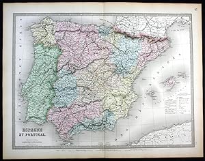
"Espagne et Portugal" - Spain Espana Spanien Portugal map Karte
Published by Paris, 1862
Language: German
Seller: Antiquariat Steffen V�lkel GmbH, Seubersdorf, Germany
Seller rating 5 out of 5 stars

Map
� 13.35
Convert currency� 24.21 shipping from Germany to United KingdomQuantity: 1 available
Add to basketoriginal handkolorierte alte Stahlstich-Landkarte von 1862 von Eugene Andriveau-Goujon (1832-1897) - Blatmasse: ca. 68 x 53 cm - gut erhalten. | original hand colored old steel engraving from 1862 by Eugene Andriveau-Goujon - size of sheet: circa 26.7 x 20.8 inches - good condition. | Dies ist ein Original! - Kein Nachdruck! - Keine Kopie! -- This is an original! - No copy! - No reprint! Wir kaufen und verkaufen alte B�cher, Handschriften, Zeichnungen, Autographen, Grafiken und Fotografien. Wir sind stets am Ankauf von kompletten Bibliotheken, Sammlungen und Nachl�ssen interessiert. Sprache: Deutsch Gewicht in Gramm: 1500.
-
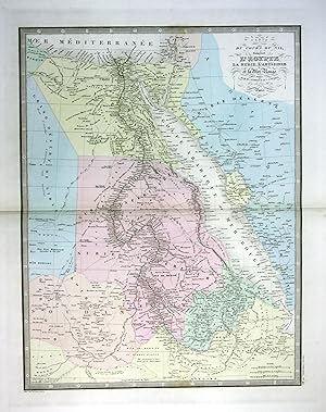
"Carte du cours du Nil comprenant l'Egypie" - Egypt �gypten Red Sea Karte map
Published by Paris, 1860
Language: German
Seller: Antiquariat Steffen V�lkel GmbH, Seubersdorf, Germany
Seller rating 5 out of 5 stars
Map
� 17.81
Convert currency� 24.21 shipping from Germany to United KingdomQuantity: 1 available
Add to basketoriginal handkolorierte alte Stahlstich-Landkarte von ca. 1860 von Eugene Andriveau-Goujon (1832-1897) - Blatmasse: ca. 68 x 53 cm - im Mittelfalz mit Randeinriss au�erhalb der Karte, sonst gut erhalten. | original hand colored old steel engraving from circa 1860 by Eugene Andriveau-Goujon - size of sheet: circa 26.7 x 20.8 inches - with marginal tear in middle fold outside the map, otherwise in good condition. | Dies ist ein Original! - Kein Nachdruck! - Keine Kopie! -- This is an original! - No copy! - No reprint! Wir kaufen und verkaufen alte B�cher, Handschriften, Zeichnungen, Autographen, Grafiken und Fotografien. Wir sind stets am Ankauf von kompletten Bibliotheken, Sammlungen und Nachl�ssen interessiert. Sprache: Deutsch Gewicht in Gramm: 1500.
-

"Oc�anie." Grenzkolorierte Kupferstich-Karte aus dem "Atlas universel de g�ographie moderne".
Published by Paris, E. Andriveau-Goujon, �diteur, 1870
Language: French
Map
� 40.08
Convert currency� 12.97 shipping from Germany to United KingdomQuantity: 1 available
Add to basketCondition: Gut. Format: 50,8 x 66,7 cm. Blatt: 51 x 68 cm. *Als Kupferstecherin bzw. Kupferstecher werden angegeben "Grav�e par Mlle. Flahaut et Smith". Weitere Angaben: "Les Ecritures par P. Rousset, les Eaux par Mme. Fontaine"; "Imp.ie de Louis Antoine". - Die Karte untergliedert die Region noch nicht in die klassischen vier Subregionen Australasien, Melanesien, Mikronesien, and Polynesien, sondern nur Melanesien, das Mailaiische Archipel und die Inseln des Pazifiks. Sprache: Franz�sisch Gewicht in Gramm: 1001.
-
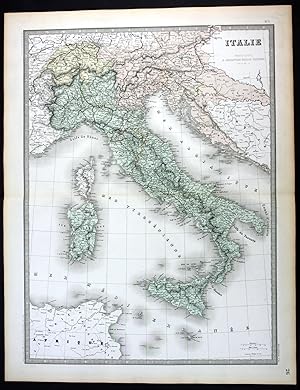
"Italie" - Italia Italy Italien Sicilia Sardegna Corse map Karte
Published by Paris, 1862
Language: German
Seller: Antiquariat Steffen V�lkel GmbH, Seubersdorf, Germany
Seller rating 5 out of 5 stars
Map
� 26.72
Convert currency� 24.21 shipping from Germany to United KingdomQuantity: 1 available
Add to basketoriginal handkolorierte alte Stahlstich-Landkarte von 1862 von Eugene Andriveau-Goujon (1832-1897) - Blatmasse: ca. 68 x 53 cm - gut erhalten. | original hand colored old steel engraving from 1862 by Eugene Andriveau-Goujon - size of sheet: circa 26.7 x 20.8 inches - good condition. | Dies ist ein Original! - Kein Nachdruck! - Keine Kopie! -- This is an original! - No copy! - No reprint! Wir kaufen und verkaufen alte B�cher, Handschriften, Zeichnungen, Autographen, Grafiken und Fotografien. Wir sind stets am Ankauf von kompletten Bibliotheken, Sammlungen und Nachl�ssen interessiert. Sprache: Deutsch Gewicht in Gramm: 1500.
-

"Algerie" - Algeria Algerien North Africa Afrika map Karte
Published by Paris, 1862
Language: German
Seller: Antiquariat Steffen V�lkel GmbH, Seubersdorf, Germany
Seller rating 5 out of 5 stars
Map
� 26.72
Convert currency� 24.21 shipping from Germany to United KingdomQuantity: 1 available
Add to basketoriginal handkolorierte alte Stahlstich-Landkarte von 1862 von Eugene Andriveau-Goujon (1832-1897) - Blatmasse: je ca. 68 x 53 cm - im Falz mit Randeinriss, sonst gut erhalten. | original hand colored old steel engraving from 1862 by Eugene Andriveau-Goujon - size of sheet: each circa 26.7 x 20.8 inches - with marginal tear in middle fold, otherwise in good condition. | Dies ist ein Original! - Kein Nachdruck! - Keine Kopie! -- This is an original! - No copy! - No reprint! Wir kaufen und verkaufen alte B�cher, Handschriften, Zeichnungen, Autographen, Grafiken und Fotografien. Wir sind stets am Ankauf von kompletten Bibliotheken, Sammlungen und Nachl�ssen interessiert. Sprache: Deutsch Gewicht in Gramm: 1500.
-

"Hemisphere Occidental" - America North South continent map Karte
Published by Paris, 1850
Language: German
Seller: Antiquariat Steffen V�lkel GmbH, Seubersdorf, Germany
Seller rating 5 out of 5 stars
Map
� 35.63
Convert currency� 24.21 shipping from Germany to United KingdomQuantity: 1 available
Add to basketoriginal handkolorierte alte Stahlstich-Landkarte von ca. 1850 von Eugene Andriveau-Goujon (1832-1897) - Blatmasse: ca. 68 x 53 cm - gut erhalten. | original hand colored old steel engraving from circa 1850 by Eugene Andriveau-Goujon - size of sheet: circa 26.7 x 20.8 inches - good condition. | Dies ist ein Original! - Kein Nachdruck! - Keine Kopie! -- This is an original! - No copy! - No reprint! Wir kaufen und verkaufen alte B�cher, Handschriften, Zeichnungen, Autographen, Grafiken und Fotografien. Wir sind stets am Ankauf von kompletten Bibliotheken, Sammlungen und Nachl�ssen interessiert. Sprache: Deutsch Gewicht in Gramm: 1500.
-

L'Europe Centrale. Publi� par E. Andriveau-Goujon . Le Trait grav� par Smith, les Ecritures par P. Rousset
Published by Paris, Imp. de Louis Antoine, 1859., 1859
Seller: Antiquariat MEINDL & SULZMANN OG, Wien - Vienna, Austria
Seller rating 5 out of 5 stars
� 249.38
Convert currency� 17.29 shipping from Austria to United KingdomQuantity: 1 available
Add to basket8�. In 32 Segmenten auf Leinen aufgezogen und faltbar eingerichtet (ca. 72,5 x 104 cm). Mit der nordafrikanischen K�stenlinie (Marokko, Algerien, Tunis, Libyen, �gypten) und den Anlegestellen der Dampfschiffe.- Die Leinenr�ckseite gebr�unt, stellenweise braunfleckig und mit Verlagsschildchen von Artaria in Wien. Das Kartenbild in nahezu fleckenfreiem Erhaltungszustand.
-
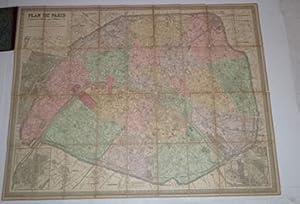
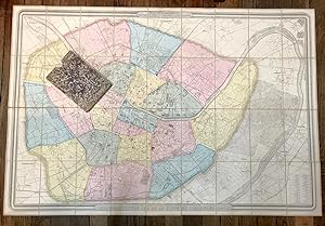
Plan de Paris a? l'echelle de 2 millim. pour 25 m�tres : indiquant les nouveaux percements et les changements de noms de voies publiques avec plans suppl�mentaires pour les Bois de Boulogne et de Vincennes.
Published by Paris : Maison Andriveau-Goujon- H.Barr�re., 1900
Seller: Wittenborn Art Books, San Francisco, CA, U.S.A.
Seller rating 5 out of 5 stars
� 266.36
Convert currency� 13.30 shipping from U.S.A. to United KingdomQuantity: 1 available
Add to basketCondition: Good. Original gilt stamped lcoth with map mouend on linen 85 x 110 cm. folding to 13 x 21cm.OCLC Number: 27861884 for the 1870 edition.PLAN DE PARIS 1/12.500Maison Andriveau Goujon. 190085 x110 cm, colori�, entoil�.
-
Plan g�om�tral de Paris et de ses agrandissements � l'�chelle d'un millim�tre pour 10 m (10,1000).
Published by Paris, Magasin de cartes g�ographiques de Longuet, 1860., 1860
� 384.76
Convert currency� 10.90 shipping from France to United KingdomQuantity: 1 available
Add to basket150,3 x 100 cm au filet ext�rieur. Entoil�, morcel� en 36 sections repli�es dans un �tui de papier cuve in-8 avec pi�ce de titre. Ce fameux plan de Paris, publi� pour la premi�re fois en 1859, se rencontre �galement � l'adresse Andriveau-Goujon, qui en est l'�diteur. Le cartouche inf�rieur donne ici l'adresse du "Magasin de cartes g�ographiques de Longuet, 8 rue de la Paix", sans doute un d�positaire. La pr�sente �dition de 1860 a �t� revue et mise � jour par les architectes Potiquet et Girodoux. Chaque arrondissement, aquarell� en bleu, rose, vert ou jaune clairs, est divis� en 4 quartiers. C'est ici l'un des tout premiers plans du Paris moderne : les faubourgs situ�s entre les fortifications de l'enceinte de Thiers et le mur des Fermiers G�n�raux venaient d'�tre annex�s, divisant ainsi, en 1859, la capitale en vingt arrondissements. Quelques grandes art�res sont d'ailleurs indiqu�es en surimpression : Bld . Henri IV, Av. Daumesnil, Bld. Arago. - Plan en bon �tat, frottements aux bords de l'�tui.
-
Plan de Paris A l'Echelle de 2 Millim. pour 2.5 Metres
Published by ANDRIVEAU-GOUJON, Paris, 1881
Seller: Argosy Book Store, ABAA, ILAB, New York, NY, U.S.A.
Seller rating 5 out of 5 stars
� 528.91
Convert currency� 31.03 shipping from U.S.A. to United KingdomQuantity: 1 available
Add to baskethardcover. Case Map. Lithograph with original hand coloring. Map measures 41 1/2" x 32 1/8" . 8 1/4" x 4 5/8" brown case with title embossed in gold. Gorgeous, highly detailed pocket map of Paris and its environs. Includes inset maps of plans for Bois de Boulogne and Bois de Vicennes which bookend the city on it's western and eastern perimeters respectively. Backed on canvas, in very good condition, some wear along folds of original linen. Eugene Andriveau-Goujon (1832 - 1897) was a French cartographer and and map publisher. He was a descendant of mapmaker Jean Goujon, who established the Andriveau-Goujon firm in Paris in 1825.
-
Plan de Paris A l'Echelle de 2 Millim. pour 2.5 Metres
Published by ANDRIVEAU-GOUJON, Paris, 1869
Seller: Argosy Book Store, ABAA, ILAB, New York, NY, U.S.A.
Seller rating 5 out of 5 stars
� 570.77
Convert currency� 31.03 shipping from U.S.A. to United KingdomQuantity: 1 available
Add to baskethardcover. Case Map. Lithograph with original hand coloring. Map measures 41 1/2" x 32 1/8" . 8 1/4" x 4 5/8" dark green case with title embossed in gold. Gorgeous, highly detailed pocket map of Paris and its environs. Includes inset maps of plans for Bois de Boulogne and Bois de Vicennes which bookend the city on it's western and eastern perimeters respectively. Backed on canvas, in very good condition, with some notations in red. Eugene Andriveau-Goujon (1832 - 1897) was a French cartographer and and map publisher. He was a descendant of mapmaker Jean Goujon, who established the Andriveau-Goujon firm in Paris in 1825.
-

Plan g�om�tral de Paris et de ses agrandissements, � l'�chelle de 1 millim�tre pour 10 m�tres.
Published by Andriveau-Goujon, Paris, 1861
Seller: Bonnefoi Livres Anciens, Paris, France
Association Member: ILAB
Seller rating 5 out of 5 stars
� 1,402.76
Convert currency� 14.70 shipping from France to United KingdomQuantity: 1 available
Add to basket1 plan colori�, repli� et entoil� de 154 x 104 cm, et 1 livret in-8 de 28 pp., couverture imprim�e, percaline brune de l'�diteur. Deuxi�me �dition revue par Potiquet. Un des premiers plans du Paris haussmannien montrant les villages annex�s entre les boulevards ext�rieurs et les fortifications.Exemplaire complet de la tr�s rare Nomenclature des rues dat�e 1860.Les teintes en vert indiquent les percements ex�cut�s avec le concours de l'�tat. Les teintes en vert indiquent les percements en cours. Les teintes en jaune indiquent les nouvelles op�rations pour lesquelles on demande le concours de l'�tat. Le liser� bleu bordant la dite teinte jaune indique les projets pour lesquels il y a eu d�claration d'utilit� publique. Le ponctu� bleu indique les percements � ex�cuter par la ville sans le concours de l'�tat. Le ponctu� jaune indique les autres percements faisant partie du syst�me d'am�lioration de la voie publique. Bel exemplaire. Vall�e, 1378.
-

Carte Gen�rale de L'Alg�rie et de la Reg�nce de Tunis General Map of Algeria and Tunisia.
Published by Paris. 1843, 1843
Seller: Peter Harrington. ABA/ ILAB., London, United Kingdom
Association Member: ABA ILAB PBFA
Seller rating 5 out of 5 stars
An attractive detailed map of the north of Algeria and Tunisia, including Malta, Sardinia and Corsica, with inset maps of Oran, Algiers, Bougie and Constantine. From the Atlas Universel Steel engraving. Good clean condition, good wide margins. the lower 12 cm of centrefold has split, no loss Later colouring. Size: 51 x 39 cm. (20 x 15� inches).
-
Carte Generale De L'Afrique d'apr�s les derni�res d�couvertes.
Published by Paris, France: Andriveau-Goujon., 1881
Seller: Wittenborn Art Books, San Francisco, CA, U.S.A.
Seller rating 5 out of 5 stars
Manuscript / Paper Collectible
� 114.15
Convert currency� 13.30 shipping from U.S.A. to United KingdomQuantity: 1 available
Add to basketCondition: Good. Four Maps 18.75" x 13.75" (per quadrant). Good with tears, toning. Some color. Text En Francais.
-

Carte g�n�rale des Etats-Unis et du Mexique comprenant l'Amerique centrale et les Antilles
Published by Parigi, 1870
Seller: libreria antiquaria perini Sas di Perini, Verona, VR, Italy
Seller rating 5 out of 5 stars
Art / Print / Poster
� 311.72
Convert currencyFree shipping from Italy to United KingdomQuantity: 1 available
Add to basketLitografia a colori, mm 1050x610. Stato di conservazione perfetto. Piega editoriale centrale. Color litograph, mm 1050x610, very good condition. The map shows the United States during an interesting time in history. While much of the eastern half of the country is well developed, the western portion still shows unmapped regions and incomplete state boundaries. The most interesting feature in the map is the odd configuration of California and Nevada, which resulted from a misunderstanding of the boundary changes that occurred when Arizona ceded land west of the Colorado and Virgin rivers to Nevada in 1866. This map shows the Nevada/Utah border too far west and the ceded region belonging to California instead of Nevada. Dakota has yet to be divided into North and South, and the borders between Idaho, Wyoming, and Montana still have yet to come to their present.Inserts show various shipping routes between Africa, Europe and the Americas as well as the newly laid Trans-Atlantic Cables. Another insert shows the region around New York City, which had by then become one of the most active and influential cities in the World. At the bottom of the map, a reference key differentiates various European possessions within the Caribbean. Nr.cat: cod 1181.
-

� 316.18
Convert currency� 17.29 shipping from Spain to United KingdomQuantity: 1 available
Add to basketCondition: ACEPTABLE. Italie / Italia perteneciente al Atlas Classique et Universel de G�ographie Ancienne et Moderne / Atlas Cl�sico y Universal de Geograf�a Antigua y Moderna de E�g�ne Andriveau-Goujon publicado en Par�s en el a�o 1877. Formato (cm): 65x59.
-

� 316.18
Convert currency� 17.29 shipping from Spain to United KingdomQuantity: 1 available
Add to basketCondition: ACEPTABLE. Iles Britanniques / Islas Brit�nicas perteneciente al Atlas Classique et Universel de G�ographie Ancienne et Moderne / Atlas Cl�sico y Universal de Geograf�a Antigua y Moderna de E�g�ne Andriveau-Goujon publicado en Par�s en el a�o 1877. Formato (cm): 64x48.
-

� 316.18
Convert currency� 17.29 shipping from Spain to United KingdomQuantity: 1 available
Add to basketCondition: ACEPTABLE. Br�sil / Brasil perteneciente al Atlas Classique et Universel de G�ographie Ancienne et Moderne / Atlas Cl�sico y Universal de Geograf�a Antigua y Moderna de E�g�ne Andriveau-Goujon publicado en Par�s en el a�o 1877. Formato (cm): 64x49.
-

� 316.18
Convert currency� 17.29 shipping from Spain to United KingdomQuantity: 1 available
Add to basketCondition: ACEPTABLE. Palestine, Ancienne & Moderne / Palestica, Antigua y Moderna perteneciente al Atlas Classique et Universel de G�ographie Ancienne et Moderne / Atlas Cl�sico y Universal de Geograf�a Antigua y Moderna de E�g�ne Andriveau-Goujon publicado en Par�s en el a�o 1877. Formato (cm): 65x49.
-

� 316.18
Convert currency� 17.29 shipping from Spain to United KingdomQuantity: 1 available
Add to basketCondition: ACEPTABLE. �tats-Unis (Etats de lOuest) / Estados Unidos (Estados del Oeste) perteneciente al Atlas Classique et Universel de G�ographie Ancienne et Moderne / Atlas Cl�sico y Universal de Geograf�a Antigua y Moderna de E�g�ne Andriveau-Goujon publicado en Par�s en el a�o 1877. Formato (cm): 64x48.
-

� 316.18
Convert currency� 17.29 shipping from Spain to United KingdomQuantity: 1 available
Add to basketCondition: ACEPTABLE. P�rou, Bolivie / Per�, Bolivia perteneciente al Atlas Classique et Universel de G�ographie Ancienne et Moderne / Atlas Cl�sico y Universal de Geograf�a Antigua y Moderna de E�g�ne Andriveau-Goujon publicado en Par�s en el a�o 1877. Formato (cm): 48x64.
-

� 316.18
Convert currency� 17.29 shipping from Spain to United KingdomQuantity: 1 available
Add to basketCondition: ACEPTABLE. Conf�d�ration Argentine et Chili / Confederaci�n de Argentinay Chile perteneciente al Atlas Classique et Universel de G�ographie Ancienne et Moderne / Atlas Cl�sico y Universal de Geograf�a Antigua y Moderna de E�g�ne Andriveau-Goujon publicado en Par�s en el a�o 1877. Formato (cm): 63x48.
-

� 316.18
Convert currency� 17.29 shipping from Spain to United KingdomQuantity: 1 available
Add to basketCondition: ACEPTABLE. Carte G�n�rale du Monde Ancien repr�sentant lesemble des Connaissances G�ographiques des Grecs et des Romains / Mapa General del Mundo Antiguo en representaci�n de todos los Conocimientos Geogr�ficos de los Griegos y los Romanos. Perteneciente al Atlas Classique et Universel de G�ographie Ancienne et Moderne / Atlas Cl�sico y Universal de Geograf�a Antigua y Modernade Eug�ne Andriveau-Goujon publicado en Par�s en el a�o 1877. Formato (cm): 39x52.
-

� 316.18
Convert currency� 17.29 shipping from Spain to United KingdomQuantity: 1 available
Add to basketCondition: ACEPTABLE. �tats Scandinaves / Estados Escandinavos perteneciente al Atlas Classique et Universel de G�ographie Ancienne et Moderne / Atlas Cl�sico y Universal de Geograf�a Antigua y Moderna de E�g�ne Andriveau-Goujon publicado en Par�s en el a�o 1877. Noruega - Suecia - Dinamarca Formato (cm): 66x48.
-

� 316.18
Convert currency� 17.29 shipping from Spain to United KingdomQuantity: 1 available
Add to basketCondition: ACEPTABLE. Espagne et Portugal / Espa�a y Portugal perteneciente al Atlas Classique et Universel de G�ographie Ancienne et Moderne / Atlas Cl�sico y Universal de Geograf�a Antigua y Moderna de E�g�ne Andriveau-Goujon publicado en Par�s en el a�o 1877. Formato (cm): 49x65.
-

� 316.18
Convert currency� 17.29 shipping from Spain to United KingdomQuantity: 1 available
Add to basketCondition: ACEPTABLE. Perteneciente al Atlas Universel, numerado 12, 15 y 24. Ejemplar en especiales buenas condiciones y de iluminaci�n bien definida y preservada. Incluye breve Explicati�n y leyenda de s�mbolos, ambos en el lado derecho. [Les Chemins de Fer par Alfred Potiquet] ; [Paris_Imprimerie de Louis Antoine, Rue de Cluny, 1] ; [Grav� : le Trait par Smith; les Montagnes par G�rin ; les Ecritures par P. Rousset; les Eaux par Mme. Fontaine.] . Formato (cm): 53x70.
-

� 351.80
Convert currency� 17.29 shipping from Spain to United KingdomQuantity: 1 available
Add to basketCondition: ACEPTABLE. Carte G�nerale de �tats-Unis et du Mexique / Mapa General de los Estados Unidos y de M�xico perteneciente al Atlas Classique et Universel de G�ographie Ancienne et Moderne / Atlas Cl�sico y Universal de Geograf�a Antigua y Moderna de E�g�ne Andriveau-Goujon publicado en Par�s en el a�o 1877. Formato (cm): 63x48.
-

� 351.80
Convert currency� 17.29 shipping from Spain to United KingdomQuantity: 1 available
Add to basketCondition: ACEPTABLE. Am�rique du Sud / Am�rica del Sur perteneciente al Atlas Classique et Universel de G�ographie Ancienne et Moderne / Atlas Cl�sico y Universal de Geograf�a Antigua y Moderna de E�g�ne Andriveau-Goujon publicado en Par�s en el a�o 1877. Formato (cm): 65x49.
-

� 351.80
Convert currency� 17.29 shipping from Spain to United KingdomQuantity: 1 available
Add to basketCondition: ACEPTABLE. Oc�anie / Oceania perteneciente al Atlas Classique et Universel de G�ographie Ancienne et Moderne / Atlas Cl�sico y Universal de Geograf�a Antigua y Moderna de E�g�ne Andriveau-Goujon publicado en Par�s en el a�o 1877. Formato (cm): 49x65.
-

� 351.80
Convert currency� 17.29 shipping from Spain to United KingdomQuantity: 1 available
Add to basketCondition: ACEPTABLE. Asie / Asia, perteneciente al Atlas Classique et Universel de G�ographie Ancienne et Moderne / Atlas Cl�sico y Universal de Geograf�a Antigua y Moderna de E�g�ne Andriveau-Goujon publicado en Par�s en el a�o 1877. Formato (cm): 39x52.