Order Total (1 Item Items):
Shipping Destination:

Alex Keith Johnston Under Direction (49 results)
Feedback
Skip to main search results
Search filters
Product Type
- All Product Types
- Books (49)
- Magazines & Periodicals (No further results match this refinement)
- Comics (No further results match this refinement)
- Sheet Music (No further results match this refinement)
- Art, Prints & Posters (No further results match this refinement)
- Photographs (No further results match this refinement)
- Maps (No further results match this refinement)
- Manuscripts & Paper Collectibles (No further results match this refinement)
Condition
- All Conditions
- New (No further results match this refinement)
- Used (49)
Binding
- All Bindings
- Hardcover (1)
- Softcover (No further results match this refinement)
Collectible Attributes
- First Edition (No further results match this refinement)
- Signed (No further results match this refinement)
- Dust Jacket (No further results match this refinement)
- Seller-Supplied Images (12)
- Not Print on Demand (49)
Language (1)
Free Shipping
- Free Shipping to United Kingdom (No further results match this refinement)
Seller Location
Seller Rating
-

The Battle of Abensberg, Antique Battle Map from Alison's History of Europe Atlas 1789 -1815
Published by William Blackwood & Sons, Edin. & London, 1875
This map shows The Battle of Abensberg on 20th April 1809. Depicted are the positions of the French & Bavarians and The Austrians; their cavalry, infantry and artillery; coloured blue and yellow, according to nationality. The hand colouring is original , that is to say it dates to the publication of the atlas in 1875. The sheet measures 11 X 8.75 inches, the actual map from its borders measures approx. 6 X 8 inches. The map is by W. & A.K. Johnston, Edin. and the scale is about 2.5 miles to the inche.The map is in very good condition, although the extreme left of the sheet is ragged where it was removed from its binding, this is well away from the actual map and would easily disappear when mounted. Otherwise the sheet is mostly quite clean with perhaps a few spots here and there.
-
The Battle of Alexandria, Antique Battle Map from Alison's History of Europe Atlas 1789 -1815
Published by William Blackwood & Sons, Edin. & London, 1875
This map shows The Battle of Alexandria on 21st march 1801. Depicted are the positions of the British and the French; their cavalry, infantry and artillery; coloured red and blue, according to nationality. The positions before the battle are shown, as are the British gun boats just off the coast.The hand colouring is original , that is to say it dates to the publication of the atlas in 1875. The sheet measures 11 X 8.75 inches, the actual map from its borders measures approx. 6 X 8 inches. The map is by W. & A.K. Johnston, Edin. and the scale is about 1.5 inches to the mile.The map is in very good condition, there is some edge wear, and some spotting at the left hand edge of the border, the map itself is mostly quite clean with the just the odd spot here or there.
-
The Battle of Arcole, Two Antique Battle Maps from Alison's History of Europe Atlas 1789 -1815
Published by William Blackwood & Sons, Edin. & London, 1875
These two maps show The Battle of Arcole on 15th, 16th, & 17th November 1796. one map shows the first day, 15th and the second map shows the third day, 17th November.Depicted are the positions of the French and Austrians; their cavalry, infantry and artillery; coloured blue and yellow, according to nationality. The hand colouring is original , that is to say it dates to the publication of the atlas in 1875. The sheets measures 11 X 8.75 inches, the actual map from its borders measures approx. 6 X 8 inches. The maps are by W. & A.K. Johnston, Edin. and the scale is about .8 inches to the mile.Both maps are in very good condition, and mostly quite clean with the just the odd spot here or there.
-
The Battle of Rivoli, Antique Battle Map from Alison's History of Europe Atlas 1789 -1815
Published by William Blackwood & Sons, Edin. & London, 1875
This map shows The Battle of Rivoli on 14th & 15th January 1797. Depicted are the positions of the French and Austrians; their cavalry, infantry and artillery; coloured blue and yellow, according to nationality. The hand colouring is original , that is to say it dates to the publication of the atlas in 1875. The sheet measures 11 X 8.75 inches, the actual map from its borders measures approx. 6 X 8 inches. The map is by W. & A.K. Johnston, Edin. and the scale is about 1.1 inches to the mile.The map is in very good condition, and is mostly quite clean with the just the odd spot here or there.
-
The Battle of Mount Thabor 1799, Antique Battle Map from Alison's History of Europe Atlas 1789 -1815
Published by William Blackwood & Sons, Edin. & London, 1875
This map shows The Battle Mount Thabor on 16th April 1799. Depicted are the positions of the French and Turks; their cavalry, infantry and artillery; coloured blue and green, according to nationality. The hand colouring is original , that is to say it dates to the publication of the atlas in 1875. The sheet measures 11 X 8.75 inches, the actual map from its borders measures approx. 6 X 8 inches. The map is by W. & A.K. Johnston, Edin. and the scale is about 4 miles to the inch.The map is in very good condition, and is mostly quite clean with the just the odd spot here or there.
-
The Battles of Turcoing & Tournay , Antique Battle Map from Alison's History of Europe Atlas 1789 -1815
Published by William Blackwood & Sons, Edin. & London, 1875
This map shows The Battles of Turcoing & Tournay on 18th May and 22nd may 1794. Depicted are the positions of the French and Allies; their cavalry, infantry and artillery; coloured blue and red , according to nationality. The positions before the battle are shown in light colouring.The hand colouring is original , that is to say it dates to the publication of the atlas in 1875. The sheet measures 11 X 8.75 inches, the actual map from its borders measures approx. 6 X 8 inches. The map is by W. & A.K. Johnston, Edin. and the scale is about .25 inches to the mile.The map is in very good condition, and is mostly quite clean with the just the odd spot here or there.
-
The Battle of Fleurus, Antique Battle Map from Alison's History of Europe Atlas 1789 -1815
Published by William Blackwood & Sons, Edin. & London, 1875
This map shows The Battle of Fleurus on 26th June 1794. Depicted are the positions of the French and Austrians; their cavalry, infantry and artillery; coloured blue and yellow, according to nationality. The positions before the battle are shown in light colouring.The hand colouring is original , that is to say it dates to the publication of the atlas in 1875. The sheet measures 11 X 8.75 inches, the actual map from its borders measures approx. 6 X 8 inches. The map is by W. & A.K. Johnston, Edin. and the scale is about .75 inches to the mile.The map is in very good condition, and is mostly quite clean with the just the odd spot here or there.
-
The Siege of Toulon , Antique Battle Map from Alison's History of Europe Atlas 1789 -1815
Published by William Blackwood & Sons, Edin. & London, 1875
This map shows The Siege of Toulon 19th December 1793. Depicted are the positions of the French and Allies; coloured blue and red , according to nationality. The march and the direction of the troops is also indicated . The ships in the roads are also depicted.The hand colouring is original , that is to say it dates to the publication of the atlas in 1875. The sheet measures 11 X 8.75 inches, the actual map from its borders measures approx. 6 X 8 inches. The map is by W. & A.K. Johnston, Edin. and the scale is about .6 inches to the mile.The map is in very good condition, and is mostly quite clean with the just the odd spot here or there.
-
The Battle of Trebbia, Antique Battle Map from Alison's History of Europe Atlas 1789 -1815
Published by William Blackwood & Sons, Edin. & London, 1875
This map shows The Battle of Trebbia on 18th, 19th & 20th June 1799. Depicted are the positions of the French and the Allied Russians & Austrians; their cavalry, infantry and artillery; coloured blue and yellow, according to nationality. positions before and after the battle are coloured light The hand colouring is original , that is to say it dates to the publication of the atlas in 1875. The sheet measures 11 X 8.75 inches, the actual map from its borders measures approx. 6 X 8 inches. The map is by W. & A.K. Johnston, Edin. and the scale is about .5 inches to the mile.The map is in very good condition, and is mostly quite clean with the just the odd spot here or there.
-
Map of the Operations Which Led to the Capitulation of Ulm , Antique Battle Map from Alison's History of Europe Atlas 1789 -1815
Published by William Blackwood & Sons, Edin. & London, 1875
Map of the Operations Which Led to the Capitulation of Ulm in October 1805. Depicted are the positions of the French and Austrians; their cavalry, infantry and artillery; coloured blue and yellow, according to nationality. The hand colouring is original , that is to say it dates to the publication of the atlas in 1875. The sheet measures 11 X 8.75 inches, the actual map from its borders measures approx. 6 X 8 inches. The map is by W. & A.K. Johnston, Edin. and the scale is about 4 miles to the inch.The map is in very good condition, and is mostly quite clean with the just the odd spot here or there.
-
The Siege of Gerona, Antique Battle Map from Alison's History of Europe Atlas 1789 -1815
Published by William Blackwood & Sons, Edin. & London, 1875
This map shows The Siege of Gerona by the French Army of Catalonia from May to October 1809. Depicted are the positions of the French batteries; coloured blue. The hand colouring is original , that is to say it dates to the publication of the atlas in 1875. The sheet measures 11 X 8.75 inches, the actual map from its borders measures approx. 6 X 8 inches. The map is by W. & A.K. Johnston, Edin. and the scale is about 2.5 inches to the mile.The sheet has some surface tearing and a ragged edge on the extreme left of the sheet where it was removed from its binding, although it is well away from the actual map and will disappear easily once the map is mounted.
-
The Battles of Smolensko and Valtelina, Antique Battle Map from Alison's History of Europe Atlas 1789 -1815
Published by William Blackwood & Sons, Edin. & London, 1875
This map shows The Battles of Smolensko and Valtelina on 17th,18th & 19th August 1812. Depicted are the positions of the French and Russians; their cavalry, infantry and artillery; coloured blue and green, according to nationality. The hand colouring is original , that is to say it dates to the publication of the atlas in 1875. The sheet measures 11 X 8.75 inches, the actual map from its borders measures approx. 6 X 8 inches. The map is by W. & A.K. Johnston, Edin. and the scale is about 1.6 inches to the mile.The map is in very good condition, and is mostly quite clean with the just the odd spot here or there.
-
The Battle of Stockach 1799, Antique Battle Map from Alison's History of Europe Atlas 1789 -1815
Published by William Blackwood & Sons, Edin. & London, 1875
This map shows The Battle of Stockach on 25th March 1799. Depicted are the positions of the French and Austrians; their cavalry, infantry and artillery; coloured blue and yellow, according to nationality. There is an inset map showing the Tyrol. The hand colouring is original , that is to say it dates to the publication of the atlas in 1875. The sheet measures 11 X 8.75 inches, the actual map from its borders measures approx. 6 X 8 inches. The map is by W. & A.K. Johnston, Edin. and the scale is about 2.5 miles to the inch.The map is in very good condition, and is mostly quite clean with the just the odd spot here or there.
-
The Battle of Culm , Antique Battle Map from Alison's History of Europe Atlas 1789 -1815
Published by William Blackwood & Sons, Edin. & London, 1875
This map shows The Battle of Culm 29th August 1813. Depicted are the positions of the French and Allies; their cavalry, infantry and artillery; coloured blue and mauve, according to nationality. The hand colouring is original , that is to say it dates to the publication of the atlas in 1875. Half the map shows the battle and the area around Culm, the other half of the map shows Saxony, part of Prussia with Lutzen, Lepzig, Dresden , Culm etc. marked. The sheet measures 11 X 8.75 inches, the actual map from its borders measures approx. 6 X 8 inches. The map is by W. & A.K. Johnston, Edin. and the scale of the battle map is about 1.25inches to the mile.The map is in very good condition, and is mostly quite clean with the just the odd spot here or there.
-
The Battle of Zurich 1799, Antique Battle Map from Alison's History of Europe Atlas 1789 -1815
Published by William Blackwood & Sons, Edin. & London, 1875
This map shows The Battle of Zurich on 4th June 1799. Depicted are the positions of the French and Austrians; their cavalry, infantry and artillery; coloured blue and yellow, according to nationality. The hand colouring is original , that is to say it dates to the publication of the atlas in 1875. The sheet measures 11 X 8.75 inches, the actual map from its borders measures approx. 6 X 8 inches. The map is by W. & A.K. Johnston, Edin. and the scale is about .8 inches to the mile.The map is in very good condition, and is mostly quite clean with the just the odd spot here or there.
-
The Battle of Jemappes, Antique Battle Map from Alison's History of Europe Atlas 1789 -1815
Published by William Blackwood & Sons, Edin. & London, 1875
This map shows The Battle of Jemappes on 6th November 1792. Depicted are the positions of the French and Austrians; their cavalry, infantry and artillery; coloured blue and yellow, according to nationality. the positions of the forces on the 5th are shown in lighter colouring. The hand colouring is original , that is to say it dates to the publication of the atlas in 1875. The sheet measures 11 X 8.75 inches, the actual map from its borders measures approx. 6 X 8 inches. The map is by W. & A.K. Johnston, Edin. and the scale is about 2.5 inches to the mile.The map is in very good condition, and is mostly quite clean with the just the odd spot here or there.
-
The Battles of Gross Beeren and Dennewitz, Antique Battle Map from Alison's History of Europe Atlas 1789 -1815
Published by William Blackwood & Sons, Edin. & London, 1875
This map shows The Battles of Gross Beeren on 23rd August 1813 and Dennewitz on 6th September 1813, half the sheet is devoted to each battle. Depicted are the positions of the French and the Allies; their cavalry, infantry and artillery; coloured blue and green, according to nationality. The hand colouring is original , that is to say it dates to the publication of the atlas in 1875. The sheet measures 11 X 8.75 inches, the actual map from its borders measures approx. 6 X 8 inches. The map is by W. & A.K. Johnston, Edin. and the scale is about .4 inches to the mile.The map is in very good condition, and is mostly quite clean with the just the odd spot here or there.
-
The Battle of Neerwinden 1793, Antique Battle Map from Alison's History of Europe Atlas 1789 -1815
Published by William Blackwood & Sons, Edin. & London, 1875
This map shows The Battle of Neerwinden on 18th March 1793. Depicted are the positions of the French and Austrians; their cavalry, infantry and artillery; coloured blue and yellow, according to nationality. the positions of the forces before the battle are shown in lighter colouring. The hand colouring is original , that is to say it dates to the publication of the atlas in 1875. The sheet measures 11 X 8.75 inches, the actual map from its borders measures approx. 6 X 8 inches. The map is by W. & A.K. Johnston, Edin. and the scale is about 1 inch to the mile.The map is in very good condition, and is mostly quite clean with the just the odd spot here or there.
-
The Siege of St Sebastian, Antique Battle Map from Alison's History of Europe Atlas 1789 -1815
Published by William Blackwood & Sons, Edin. & London, 1875
This map shows The Siege of St Sebastian by the Allies under Wellington from June to September 1813. Depicted are the positions of the allied forces; coloured red. The hand colouring is original , that is to say it dates to the publication of the atlas in 1875. The sheet measures 11 X 8.75 inches, the actual map from its borders measures approx. 6 X 8 inches. The map is by W. & A.K. Johnston, Edin. and the scale is about 3 inches to the mile.The map is in very good condition, and the sheet is very clean with perhaps the just the odd spot here or there.
-
The Battle of Borodino, Antique Battle Map from Alison's History of Europe Atlas 1789 -1815
Published by William Blackwood & Sons, Edin. & London, 1875
This map shows The Battle of Borodino on 7th September 1812. Depicted are the positions of the French and Russians; their cavalry, infantry and artillery; coloured blue and green, according to nationality. The hand colouring is original , that is to say it dates to the publication of the atlas in 1875. The sheet measures 11 X 8.75 inches, the actual map from its borders measures approx. 6 X 8 inches. The map is by W. & A.K. Johnston, Edin. and the scale is about .9 inches to the mile.The map is in very good condition, and is mostly quite clean with the just the odd spot here or there.
-
The Battle of Maro-Jaroslawitz, Antique Battle Map from Alison's History of Europe Atlas 1789 -1815
Published by William Blackwood & Sons, Edin. & London, 1875
This map shows The Battle of Malo-Jaroslawitz on 24th Octoberr 1812. Depicted are the positions of the French and Russians; their cavalry, infantry and artillery; coloured blue and green, according to nationality. The hand colouring is original , that is to say it dates to the publication of the atlas in 1875. The sheet measures 11 X 8.75 inches, the actual map from its borders measures approx. 6 X 8 inches. The map is by W. & A.K. Johnston, Edin. and the scale is about 1.6 inches to the mile.The map is in very good condition, and is mostly quite clean with the just the odd spot here or there.
-
The Battle of Lutzen, Antique Battle Map from Alison's History of Europe Atlas 1789 -1815
Published by William Blackwood & Sons, Edin. & London, 1875
This map shows The Battle of Lutzen on 2nd May 1813. Depicted are the positions of the the Allies and French; their cavalry, infantry and artillery; coloured mauve and blue, according to nationality. The hand colouring is original , that is to say it dates to the publication of the atlas in 1875. The sheet measures 11 X 8.75 inches, the actual map from its borders measures approx. 6 X 8 inches. The map is by W. & A.K. Johnston, Edin. and the scale is about 1 inch to the mile.The map is in very good condition, and is mostly quite clean with the just the odd spot here or there.
-
The Battle of Hanau, Antique Battle Map from Alison's History of Europe Atlas 1789 -1815
Published by William Blackwood & Sons, Edin. & London, 1875
This map shows The Battle of Hanau on 30th October 1813. Depicted are the positions of the the French and the Bavarians & Austrians; their cavalry, infantry and artillery; coloured blue and yellow, according to nationality. The hand colouring is original , that is to say it dates to the publication of the atlas in 1875. The sheet measures 11 X 8.75 inches, the actual map from its borders measures approx. 6 X 8 inches. The map is by W. & A.K. Johnston, Edin. and the scale is about 4 inches to the mile.The map is in very good condition, and the sheet is very clean with perhaps the just the odd spot here or there.
-
The Battle of the Katzbach, Antique Battle Map from Alison's History of Europe Atlas 1789 -1815
Published by William Blackwood & Sons, Edin. & London, 1875
This map shows The Battle of the Katzbach on 26th August 1813. Depicted are the positions of the the French and the Russians & Prussians; their cavalry, infantry and artillery; coloured blue, green or mauve, according to nationality. The hand colouring is original , that is to say it dates to the publication of the atlas in 1875. The sheet measures 11 X 8.75 inches, the actual map from its borders measures approx. 6 X 8 inches. The map is by W. & A.K. Johnston, Edin. and the scale is about .8 inches to the mile.The map is in very good condition, and the sheet is very clean with perhaps the just the odd spot here or there.
-
The Battle of Dresden, Antique Battle Map from Alison's History of Europe Atlas 1789 -1815
Published by William Blackwood & Sons, Edin. & London, 1875
This map shows The Battle of Dresden on 26th & 27th August 1813. Depicted are the positions of the the Austrians, Russians, Prussians and French; their cavalry, infantry and artillery; coloured yellow, mauve, green and blue, according to nationality. The hand colouring is original , that is to say it dates to the publication of the atlas in 1875. The sheet measures 11 X 8.75 inches, the actual map from its borders measures approx. 6 X 8 inches. The map is by W. & A.K. Johnston, Edin. and the scale is about .9 inches to the mile.The map is in very good condition, and the sheet is very clean with perhaps the just the odd spot here or there.
-
The Battle of Vimeira, Antique Battle Map from Alison's History of Europe Atlas 1789 -1815
Published by William Blackwood & Sons, Edin. & London, 1875
This map shows The Battle of Vimeira on 21st August 1808. Depicted are the positions of the Allies and the French; their cavalry, infantry and artillery; coloured red and blue, according to nationality. The hand colouring is original , that is to say it dates to the publication of the atlas in 1875. The sheet measures 11 X 8.75 inches, the actual map from its borders measures approx. 6 X 8 inches. The map is by W. & A.K. Johnston, Edin. and the scale is about 1.5 inches to the mile.The map is in very good condition, there is some adhesive remaining along the extreme left of the sheet where it was removed from its binding, this is well away from the actual map and would easily disappear when mounted. Otherwise the sheet is mostly quite clean with perhaps the just the odd spot here or there.
-
The Battle of Ocana, Antique Battle Map from Alison's History of Europe Atlas 1789 -1815
Published by William Blackwood & Sons, Edin. & London, 1875
This map shows The Battle of Ocana on 19th November 1809. Depicted are the positions of the French and Spanish; their cavalry, infantry and artillery; coloured red and blue, according to nationality. The hand colouring is original , that is to say it dates to the publication of the atlas in 1875. The sheet measures 11 X 8.75 inches, the actual map from its borders measures approx. 6 X 8 inches. The map is by W. & A.K. Johnston, Edin. and the scale is about 1. inch to the mile.The map is in very good condition, there is a little surface tearing at the extreme left of the sheet where it was removed from its binding, this is well away from the actual map and would easily disappear when mounted. Otherwise the sheet is mostly quite clean with perhaps the just the odd spot here or there.
-
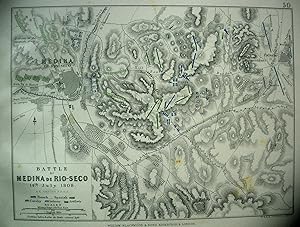
The Battle of Medina De Rio-Seco, Antique Battle Map from Alison's History of Europe Atlas 1789 -1815
Published by William Blackwood & Sons, Edin. & London, 1875
This map shows The Battle of Medina De Rio-Seco on 14th July 1808. Depicted are the positions of the French and Spanish; their cavalry, infantry and artillery; coloured blue and green, according to nationality. The hand colouring is original , that is to say it dates to the publication of the atlas in 1875. The sheet measures 11 X 8.75 inches, the actual map from its borders measures approx. 6 X 8 inches. The map is by W. & A.K. Johnston, Edin. and the scale is about 2. inches to the mile.The map is in very good condition, there is some adhesive remaining along the extreme left of the sheet where it was removed from its binding, this is well away from the actual map and would easily disappear when mounted. Otherwise the sheet is mostly quite clean with perhaps the just the odd spot here or there.
-
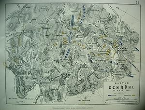
The Battle of Echmuhl, Antique Battle Map from Alison's History of Europe Atlas 1789 -1815
Published by William Blackwood & Sons, Edin. & London, 1875
This map shows The Battle of Echmuhl on 22nd April 1809. Depicted are the positions of the French the Austrians; their cavalry, infantry and artillery; coloured blue and yellow, according to nationality. The hand colouring is original , that is to say it dates to the publication of the atlas in 1875. The sheet measures 11 X 8.75 inches, the actual map from its borders measures approx. 6 X 8 inches. The map is by W. & A.K. Johnston, Edin. and the scale is about 2. miles to the inch.The map is in very good condition, although the extreme left of the sheet is ragged where it was removed from its binding, this is well away from the actual map and would easily disappear when mounted. Otherwise the sheet is mostly quite clean with perhaps a few spots here and there.
-
Map of Parts of France & Belgium to Illustrate the Campaigns of 1814-15, Antique Battle Map from Alison's History of Europe Atlas 1789 -1815
Published by William Blackwood & Sons, Edin. & London, 1875
This map shows parts of France & Belgium to Illustrate the Campaigns of 1814-15. The map is hand coloured in red and blue, with the sites of battles underlined in red.The hand colouring is original , that is to say it dates to the publication of the atlas in 1875. The sheet measures 11 X 8.75 inches, the actual map from its borders measures approx. 6 X 8 inches. The map is by W. & A.K. Johnston, Edin. and the scale is about 20 miles to one inch.The map is in very good condition, and very clean with a little foxing although most of it confined to the border, and one very small edge tear well away from the actual map.