
Order Total (1 Item Items):
Shipping Destination:

Generalstab Des Heeres, Abteilung Fur Kriegskarten Und Vermessungswesen Iv Mil Geo (16 results)
Feedback
Skip to main search results
Search filters
Product Type
- All Product Types
- Books (6)
- Magazines & Periodicals (No further results match this refinement)
- Comics (No further results match this refinement)
- Sheet Music (No further results match this refinement)
- Art, Prints & Posters (No further results match this refinement)
- Photographs (No further results match this refinement)
- Maps (10)
- Manuscripts & Paper Collectibles (No further results match this refinement)
Condition Learn more
- New (No further results match this refinement)
- As New, Fine or Near Fine (3)
- Very Good or Good (13)
- Fair or Poor (No further results match this refinement)
- As Described (No further results match this refinement)
Binding
- All Bindings
- Hardcover (No further results match this refinement)
- Softcover (5)
Collectible Attributes
- First Edition (No further results match this refinement)
- Signed (No further results match this refinement)
- Dust Jacket (No further results match this refinement)
- Seller-Supplied Images (16)
- Not Print on Demand (16)
Language (1)
Price
- Any Price
- Under � 20 (No further results match this refinement)
- � 20 to � 35 (No further results match this refinement)
- Over � 35
Free Shipping
- Free Shipping to U.S.A. (No further results match this refinement)
Seller Location
Seller Rating
-
Stadtdurchfahrtpl�ne England (ohne London). Abgeschlossen 30. June 1940. Anlage zu Mil.-Geo.-Angaben �ber England.
Published by Berlin: Generalstab des Heeres: Abteilung f�r Kriegskarten und Vermessungswesen,1940., 1940
Language: German
Seller: Jack Baldwin Rare Books, Glasgow, United Kingdom
Seller rating 5 out of 5 stars

� 50
Convert currency� 14.40 shipping from United Kingdom to U.S.A.Quantity: 1 available
Add to basketSoft cover. Condition: Very Good. [2], 117p. 1 folding map (without tears). Printed soft grey covers. At head of title-page: Nur f�r den Dienstgebrauch! [for official use only]. ***** A volume of plans printed in black and yellow (many folding) of the cities and major towns of England, excluding London. Intended for the German military in preparation for an invasion of Great Britain in the early part of the Second World War (known as Unternehmen Seel�we , in German, or Operation Sealion in English).
-
Milit�rgeographische Angaben �ber England Textheft. 2. Auflage. Abgeschlossen am 1. September 1940. + Bildheft: England insgesamt 2. Auflage. Abgeschlossen am 1. September 1940.
Published by Berlin: Generalstab des Heeres: Abteilung f�r Kriegskarten und Vermessungswesen (IV. Mil.-Geo.), 1940., 1940
Language: German
Seller: Jack Baldwin Rare Books, Glasgow, United Kingdom
Seller rating 5 out of 5 stars
� 200
Convert currency� 14.40 shipping from United Kingdom to U.S.A.Quantity: 1 available
Add to basketSoft cover. Condition: Very Good. 2 vols. Textheft: 236p. 2 folding maps (without tears) at rear. Printed green card covers, sunned at spine and edges. Bildhelft: [4], 177 pages (mainly black and white photographs). Printed green card covers, sunned at spine and edges. Very slight bump at lower outer corner of first forty pages. At head of title-page: Nur f�r den Dienstgebrauch! [for official use only]. ***** Military and geographical information about England as a whole. The Textheft is arranged as a gazetteer of English cities and towns. The Bildheft contains 174 photographs of English cities and towns (including some aerial views). Intended for the German military in preparation for an invasion of Great Britain in the early part of the Second World War (known as Unternehmen Seel�we , in German, or Operation Sealion in English).
-
Milit�rgeographische Angaben �ber England: S�dk�ste. Text- und Bildheft mit Kartenanlagen, mit 1. und 2. Nachtrag. Abgeschlossen am 15. August 1940. + Milit�rgeographische Angaben �ber England: S�dk�ste. 3. Nachtrag zum Text- und Bildheft. Geneigtaufnahmen vom Ostabschnitt (Littlehampton bis Margate) mit Text und Kartenanlage. Abgescholossen am 31. Mai 1941.
Published by Berlin: Generalstab des Heeres: Abteilung f�r Kriegskarten und Vermessungswesen (IV. Mil.-Geo.),1940-41., 1940
Language: German
Seller: Jack Baldwin Rare Books, Glasgow, United Kingdom
Seller rating 5 out of 5 stars
� 300
Convert currency� 14.40 shipping from United Kingdom to U.S.A.Quantity: 1 available
Add to basketSoft cover. Condition: Very Good. photographs), 1 unnumbered coloured folding map without tears) before page 15, 1 unnumbered coloured folding map before page 23; 1-49 coloured maps (so numbered in purple) within body of book; 1 folding coloured map attached to inner rear cover. Printed green card covers (slightly sunned at edges). Vol. 2 (3. Nachtrag): 65 (folded) pages of black and white photographs; 1 folding coloured map (without tears) attached to inner rear cover. Printed green card covers (slightly sunned at edges). At head of title-pages: Nur f�r den Dienstgebrauch! [for official use only]. ***** Intended for the German military in preparation for an invasion of Great Britain in the early part of the Second World War (known as Unternehmen Seel�we in German, or Operation Sealion in English). The profuse black and white photographs and coloured maps identify targets such as harbours, ports, cities and towns. The two volumes cover geographically the South coast of England and hinterland.
-
Entwurf Militargeographische Angaben uber Marokko (Nur fur den Dienstgebrauch!)
Published by Generalstab des Heeres, Berlin, 1942
Language: German
� 675
Convert currency� 25 shipping from United Kingdom to U.S.A.Quantity: 1 available
Add to basketSoft cover. Condition: Very Good. Original buff printed light card slipcase 16x21x5cm, complete with Textheft (wraps, 153pp with several b/w maps, one folding); Ortsbeschreibungen (wraps, 47pp with many b/w town plans); Bildheft (landscape wraps, (2)pp prelims, (1) Index map, 146 captioned full-page b/w photos, (3)pp Index); and 8 colour paper maps and plans as called for. The three volumes are very good, tanned, with some marks and light creasing. The maps and plans are neatly folded, foxed, with one or two short closed tears. Case fair with tears and minor loss. Completed on 20 July 1942, this rare and confidential German military intelligence handbook was issued to help the Axis defend Morocco during the North African Campaign, which was then under the control of the Vichy French and Spain. TEXT: The Text volume, mostly printed to the rectos only, is stated as an incomplete draft, with all departments asked to write comments and help complete it (p2). It organises information into: A. Overview (location, borders, size, history, admin); physical geography; population and settlement; economy; transport); B. Individual Landscapes (Rif Atlas; western Morocco; Middle Atlas; High Atlas; southern Morocco; eastern Morocco; and the north coast); and C. Details (admin divisions; geographical terms; water; electric power stations in French Morocco; route descriptions; airfields and main landing sites; main telephone lines and radio stations, etc). The ORTSBESCHREIBUNGEN includes 26 of the most important settlements in French and Spanish Morocco, including Tangier. They were selected based on their size, number of inhabitants, and military, administrative and economic importance. They are presented alphabetically from Agadir to Tiznit, each with b/w plan and description. BILDHEFT: the Picture volume follows the order of landscapes presented in Text Volume (B). Naturally, there is much focus on transport links, city layouts, factories etc. There are also images of traditional architecture and people. MAPS: the 8 highly detailed maps include: Ubersichtskarte von Marokko 1:2,000,000, 71x70cm; Strassenkarte von Marokko 1:1,000,000, 110x100cm with insets for Casablanca to Rabat, environs of Fes, Mogador to Agadir, and environs of Marrakesh; and 6x 1:10,000 Mil-Geo Plans for Casablanca 81x75cm; Rabat-Sale 60x80cm; Port Lyautey and Mehdia 70x80cm (3 plans on 1 sheet); Meknes 68x70cm; Fes 65x75cm; and Marrakech 74x66cm. Some have printed text to their versos.
-
Entwurf Militargeographische Angaben uber Agypten (Nur fur den Dienstgebrauch!)
Published by Generalstab des Heeres, Berlin, 1942
Language: German
� 1,875
Convert currency� 25 shipping from United Kingdom to U.S.A.Quantity: 1 available
Add to basketSoft cover. Condition: Very Good. Original printed orange card case 16x23x5cm, complete with Textheft (wraps, 196pp with several b/w maps and plans, some folding); Bildheft (landscape wraps, (2)pp prelims, (1) Index map, 172 captioned photos mostly full-page o/w 4 colour, (4)pp Index); and 3 colour folding maps on 6 sheets as called for. Volumes very good or better, tanned, with some dusting to wraps. Maps neatly folded with some closed tears. Case good with tears especially to spine head, some small repairs and minor loss. Completed on 20 June 1942, this rare and confidential intelligence handbook was issued at the height of Rommel's advance on Egypt. It coincides with the fall of Tobruk (17-21 June), which gained the Axis a port nearer the Aegean-Crete route, and Rommel a promotion to Field-Marshal. On 22 June, Rommel asked Mussolini to postpone the invasion of Malta so he could continue his offensive with necessary air support. Mussolini referred the matter to Hitler, who agreed the following day. Churchill described the loss as "one of the heaviest blows I can recall during the war. Not only were its military effects grievous, but it had affected the reputation of the British armies". This work was thus issued to inform the continuation of the offensive. TEXT VOLUME: this greatly expands on and corrects an earlier Handbook on Northeast Africa. Most leaves are printed to the rectos only, allowing space for additions and corrections which must be reported immediately: "Cooperation of all required!" (p2). Information is organised into: A. Overview (access; location, borders, size, state, admin, history; physical geography; population and settlement; economy; transport); B. Individual Landscapes (Western Desert; Nile and Delta; Isthmus of Suez and Sinai Peninsula; Eastern Desert; coast); and C. Details (admin divisions; climate; water; irrigation and drainage; population distribution by nationality; route descriptions; airports; etc). Illustrated with maps throughout, Section C also includes several detailed town plans (Asiut, Assuan, Bandar Benha, Beni Suef, Damanhur, El Mahalla El Kubra, Mansura, el Minya, El Simbillawein, Heliopolis, Hurghada (including Anglo-Egyptian oil installations), Kena, Luksor, Mit Ghamr, Zagazig, Shibin el Kom, Zifta, Talkha, Tanta). PICTURE VOLUME opens with 12 images representing characteristic desert landscapes. The rest follows the order of landscapes presented in Text Volume (B). Those of the Western Desert include striking views of camel caravans, cars negotiating their way through the Great Sand Sea, desert camps, the oases including their people and architecture. Other highlights include transport, agriculture, infrastructure, factories etc. There are several aerial views among them, of the Nile and Alexandria, and of Cairo, one with the massive shadow of an airship over the Citadel. MAPS: The 3 highly detailed maps on 6 sheets include: Ubersichtskarte von Agypten 1:2,000,000 89x80cm; Befahrbarkeitskarte 1:500,000 (2 adjoining sheets): Nr.1 Matruch 103x66cm, Nr.2 Kairo 100x66cm; and Karte der wichtigsten Kanal- und Flubeubergange in Agypten 1:500,000 (3 adjoining sheets): Blatt 1: Kairo 74x72cm, 2: Assiut 49x76cm, 3: Kena 50x75cm.
-
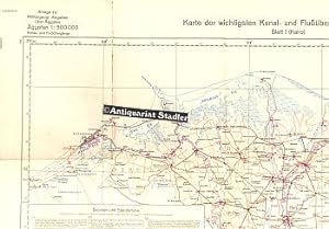
Karte der wichtigsten Kanal- und Flu��berg�nge in �gypten. Blatt 1 (Kairo). Sonderausgabe. Ausgabe Nr. 2 Stand: 1. VI. 1942. Nur f�r den Dienstgebrauch! Anlage zu: Milit�rgeogr. Angaben �ber �gypten. Kanal- und Flu��berg�nge.
Published by Ohne Ort, o.Vlg., 1942
Language: German
Map
� 49.18
Convert currency� 39.06 shipping from Germany to U.S.A.Quantity: 1 available
Add to basket71x74 cm Querformat. Condition: Sehr gut. Mehrfarbige Faltkarte im Ma�stab 1:500.000. - sehr gut erhalten, an einigen Faltkanten etw. gebr�unt. -- Mit Angaben von F�hren, Br�cken und Staud�mmen. Zahlungen mit PayPal m�glich. Sprache: Deutsch Gewicht in Gramm: 777.
-

Karte der wichtigsten Kanal- und Flu��berg�nge in �gypten. Blatt 2 (Assiut). Sonderausgabe. Ausgabe Nr. 1 Stand: 1941. Nur f�r den Dienstgebrauch! Anlage zu: Milit�rgeogr. Angaben �ber �gypten. Br�cken und F�hren.
Published by Ohne Ort, o.Vlg., 1941
Language: German
Map
� 49.18
Convert currency� 39.06 shipping from Germany to U.S.A.Quantity: 1 available
Add to basket75x50 cm. Condition: Sehr gut. Mehrfarbige Faltkarte im Ma�stab 1:500.000. - sehr gut erhalten, an einigen Faltkanten etw. gebr�unt. -- Mit Aufz�hlung von Br�cken und F�hren. Zahlungen mit PayPal m�glich. Sprache: Deutsch Gewicht in Gramm: 888.
-

Karte der wichtigsten Kanal- und Flu��berg�nge in �gypten. Blatt 3 (Kena). Sonderausgabe. Ausgabe Nr. 1 Stand: 1941. Nur f�r den Dienstgebrauch! Anlage zu: Milit�rgeogr. Angaben �ber �gypten. Kanal- und Flu��berg�nge.
Published by Ohne Ort, o.Vlg., 1941
Language: German
Map
� 49.18
Convert currency� 39.06 shipping from Germany to U.S.A.Quantity: 1 available
Add to basket75x50 cm. Condition: Sehr gut. Mehrfarbige Faltkarte im Ma�stab 1:500.000. - sehr gut erhalten, an einigen Faltkanten etw. gebr�unt. -- Mit Aufz�hlung von Br�cken und F�hren. Zahlungen mit PayPal m�glich. Sprache: Deutsch Gewicht in Gramm: 888.
-
Grossbritannien und Irland: Funkstellen. Anlage zu Mil.-Geo-Angaben �ber England. 2. Auflage.
Published by Berlin: 1940., 1940
Language: German
Seller: Jack Baldwin Rare Books, Glasgow, United Kingdom
Seller rating 5 out of 5 stars
Map
� 80
Convert currency� 14.40 shipping from United Kingdom to U.S.A.Quantity: 1 available
Add to basketNo Binding. Condition: Very Good. 1 folding map (without tears) showing radio and telegraph communications in Great Britain, including police, fire service, naval and army communication centres. In top margin: Nur f�r den Dienstgebrauch! [for official use only]. ***** Intended for the German military in preparation for an invasion of Great Britain in the early part of the Second World War (known as Unternehmen Seel�we , in German, or Operation Sealion in English).
-
Grossbritannien: Fernverkehrsstrassen. Anlage zu Mil.-Geo.-Angaben �ber England.
Published by Berlin: 1940., 1940
Language: German
Seller: Jack Baldwin Rare Books, Glasgow, United Kingdom
Seller rating 5 out of 5 stars
� 80
Convert currency� 14.40 shipping from United Kingdom to U.S.A.Quantity: 1 available
Add to basketNo Binding. Condition: Very Good. 1 folding map printed in black, blue, red and yellow (without tears but with a few outer folds slightly sunned)) showing major roads and highways of Great Britain. In top margin: Sonderausgabe VII. 40. Nur f�r den Dienstgebrauch! [for official use only]. ***** Intended for the German military in preparation for an invasion of Great Britain in the early part of the Second World War (known as Unternehmen Seel�we , in German, or Operation Sealion in English).
-
Grossbritannien: �bersicht der Gew�sser: Anlage zu Mil. Geo.-Angaben von England.
Published by Berlin: 1940., 1940
Language: German
Seller: Jack Baldwin Rare Books, Glasgow, United Kingdom
Seller rating 5 out of 5 stars
Map
� 80
Convert currency� 14.40 shipping from United Kingdom to U.S.A.Quantity: 1 available
Add to basketNo Binding. Condition: Very Good. 1 folding map printed in black, blue and yellow (without tears) of the waterways of Great Britain. In top margin: Sonderausgabe VII. 40. Nur f�r den Dienstgebrauch! [for official use only]. ***** Intended for the German military in preparation for an invasion of Great Britain in the early part of the Second World War (known as Unternehmen Seel�we , in German, or Operation Sealion in English).
-
Elektrizit�tsversorgung von England und Schottland. Anlage zu Mil.-Geo-Angaben �ber England. Das Kraftnetz des C.E.B. (Central Electricity Board = Elektrizit�tsamt. Stand 1939. Ausgabe 1940.
Published by Berlin: 1940., 1940
Language: German
Seller: Jack Baldwin Rare Books, Glasgow, United Kingdom
Seller rating 5 out of 5 stars
Map
� 80
Convert currency� 14.40 shipping from United Kingdom to U.S.A.Quantity: 1 available
Add to basketNo Binding. Condition: Very Good. 1 folding map printed in black and red (without tears); outer folds slightly sunned. In top margin: Nur f�r den Dienstgebrauch! [for official use only]. ***** A map showing the sources of electricity, power stations, etc. in England and Scotland. Intended for the German military in preparation for an invasion of Great Britain in the early part of the Second World War (known as Unternehmen Seel�we , in German, or Operation Sealion in English).
-
Grosssbritannien: 1000000. �bersichtskarte mit Ortschaftsverzeichnis und Blatteinteilung f�r die deutsche Sonderausgabe von England 1:100000. Ausgabe 1940.
Published by Berlin: 1940., 1940
Language: German
Seller: Jack Baldwin Rare Books, Glasgow, United Kingdom
Seller rating 5 out of 5 stars
Map
� 80
Convert currency� 14.40 shipping from United Kingdom to U.S.A.Quantity: 1 available
Add to basketNo Binding. Condition: Very Good. 1 folding map printed in black and light blue (without tears). In top margin: Nur f�r den Dienstgebrauch! [for official use only]. ***** Intended for the German military in preparation for an invasion of Great Britain in the early part of the Second World War (known as Unternehmen Seel�we , in German, or Operation Sealion in English).
-
Grossbritannien und Irland: Eisenbahnnetz mit Stationsverzeichnis. 1: 1000000. Anlage zu Mil.-Geo.-Angaben �ber England. + Stationsverzeichnis zur Karte Grossbritannien und Irland. Eisenbahnnetz 1: 1000000. 2. Auflage. Abgeschlossen am 1. September 1940.
Published by Berlin: Generalstab des Heeres: Abteilung f�r Kriegskarten und Vermessungswesen (IV. Mil.-Geo.), 1940., 1940
Language: German
Seller: Jack Baldwin Rare Books, Glasgow, United Kingdom
Seller rating 5 out of 5 stars
Map
� 80
Convert currency� 14.40 shipping from United Kingdom to U.S.A.Quantity: 1 available
Add to basketNo Binding. Condition: Very Good. 1 folding black and white map (without tears). In top margin: Sonderausgabe VII/40. Nur f�r den Dienstgebrauch! [for official use only]. Stationsverzeichnis: 34p. Printed green card covers, sunned at spine and edges. At head of title-page of Stationsverzeichnis: Nur f�r den Dienstgebrauch! [for official use only]. ***** A map of the railway network of Great Britain and Ireland + Index of stations. Intended for the German military in preparation for an invasion of Great Britain in the early part of the Second World War (known as Unternehmen Seel�we , in German, or Operation Sealion in English).
-
England: Bev�lkerungsverteilung 1931: Anlage zu Mil.-Geo.Angaben �ber England. Ausgabe 1.8.40.
Published by Berlin: 1940., 1940
Language: German
Seller: Jack Baldwin Rare Books, Glasgow, United Kingdom
Seller rating 5 out of 5 stars
Map
� 100
Convert currency� 14.40 shipping from United Kingdom to U.S.A.Quantity: 1 available
Add to basketNo Binding. Condition: Very Good. 1 folding coloured map (without tears) showing the population densities in Great Britain 1in 1931. In top margin: Sonderausgabe IX. 1940. Nur f�r den Dienstgebrauch! [for official use only]. ***** Intended for the German military in preparation for an invasion of Great Britain in the early part of the Second World War (known as Unternehmen Seel�we , in German, or Operation Sealion in English).
-
England: Milit�rgeographische Operationskarte, Massstab 1:500000. S�dblatt. Mil. Geo-Operationskarte: Anlage zu Mil. Geo.-Angaben zu England, Ausg. 15.8.1940.
Published by Berlin: 1940., 1940
Language: German
Seller: Jack Baldwin Rare Books, Glasgow, United Kingdom
Seller rating 5 out of 5 stars
Map
� 100
Convert currency� 14.40 shipping from United Kingdom to U.S.A.Quantity: 1 available
Add to basketNo Binding. Condition: Very Good. 1 folding coloured map (without tears). In top margin: Sonderausgabe! Nur f�r den Dienstgebrauch! [for official use only]. ***** Intended for the German military in preparation for an invasion of Great Britain in the early part of the Second World War (known as Unternehmen Seel�we , in German, or Operation Sealion in English).


