
Order Total (1 Item Items):
Shipping Destination:

1628 Mercator Map (2 results)
Feedback
Skip to main search results
Search filters
Product Type
- All Product Types
- Books (1)
- Magazines & Periodicals (No further results match this refinement)
- Comics (No further results match this refinement)
- Sheet Music (No further results match this refinement)
- Art, Prints & Posters (No further results match this refinement)
- Photographs (No further results match this refinement)
- Maps (1)
- Manuscripts & Paper Collectibles (No further results match this refinement)
Condition Learn more
- New (No further results match this refinement)
- As New, Fine or Near Fine (No further results match this refinement)
- Very Good or Good (No further results match this refinement)
- Fair or Poor (No further results match this refinement)
- As Described (2)
Binding
- All Bindings
- Hardcover (No further results match this refinement)
- Softcover (No further results match this refinement)
Collectible Attributes
- First Edition (1)
- Signed (No further results match this refinement)
- Dust Jacket (No further results match this refinement)
- Seller-Supplied Images (2)
- Not Print on Demand (2)
Language (1)
Free Shipping
Seller Location
Seller Rating
-
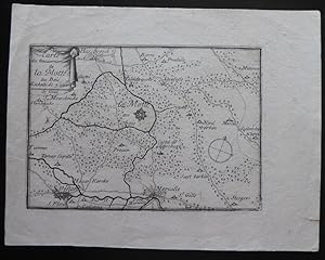
La Motte, France, 6 1/4" x 8", with image 4 1/4" x 6". Some edge wear, blank back.
-

America, siue, India Nova. Ad magnae Gerardi Mercatoris aui vniversalis imitationem in compendium redacta.
Publication Date: 1595
Seller: Geographicus Rare Antique Maps, Brooklyn, NY, U.S.A.
Association Member: ABAA ESA ILAB
Seller rating 4 out of 5 stars

Map First Edition
Very good. Some toning and foxing. Mended centerfold split; printers' crease. Size 14.5 x 18.25 Inches. This is a vivid 1628 Hondius edition of Mercator's 1595 America , one of the most visually arresting early maps of the Western Hemisphere. Michael Mercator Michael Mercator has framed his grandfather's geography in a circular border surrounded by intertwined cornucopiae and vines. The circular motif is repeated in the engraving's corners, with four medallions bearing the cartouche and three inset maps depicting the Gulf of Mexico, Cuba, and Haiti. Taken together, it is a unique and artful depiction of arguably the most important new discoveries to be included in the 1595 Mercator Atlas . (Incidentally, this format [circular central maps with corner medallions and acanthus borderwork] is most unusual and evident in only two Mercator atlas maps, both 1595 editions: the present map and Mercator's iconic Arctic. Although only one of these maps bears Michael Mercator's imprint, he was clearly an accomplished engraver, and we must speculate whether he also had a hand in the Arctic map) A Family Affair The geographical information is likely derived from Gerard Mercator's lost 1569 wall map of America, while the projection resembles that used by Gerard's son Rumold in his 1587 double-hemisphere map of the world. The map's design and execution were the work of the elder's grandson, Michael, shortly after Gerard's death in 1594. The present work is the sole map to bear Michael's imprint - but it is evidently not the work of a beginner. The skill of the engraving speaks to a long apprenticeship under the elder Mercator. The Caribbean Insets At the time this map was executed, it represented the only map in the Mercator atlas that would be dedicated to the western hemisphere. The 'Mercator/Hondius' maps of the American southeast, the Caribbean islands, and the Strait of Magellan would not be added to the Atlas until it was in the hands of Jodocus Hondius. This being the case, Mercator's inclusion of the Caribbean and the Gulf of Mexico in the three roundels on this map represented the sharpest focus on any specific part of the Americas in the Atlas . Mercator chose to highlight a) the Gulf of Mexico, b) the waters around Cuba, Jamaica, Florida, and the Bahamas, and c) the island of Hispaniola. Here, Mercator's use of the place name 'Haiti' is distinctive: the elder Mercator being the earliest to use it consistently. Norombega This riverside city in the northeast part of North America perpetuated a tale of a mysterious, legendary city. It appeared on many early maps of New England, starting with Verrazano's 1529 manuscript map of America. He used the term, Oranbega , which in Algonquin means 'lull in the river'. The first detailed reference to Norombega appeared in the 1542 journals of the French navigator Jean Allefonsce, who discovered and apparently sailed some distance up the Penobscot River, where he encountered a fur-rich American Indian city, to which he applied the placename. After that, the existence of the city would be supported by later travelers - Andre Thevet (1502 - 1590) in 1550 and David Ingram in 1562. Ingram, in particular, produced an elaborately embroidered report inspired by the legends of El Dorado, Cibola, and other lost cities. Thus, Norombega was established as a fabulous city of riches, inspiring expeditions such as that of Samuel de Champlain (1567 - 1635). A Hint at the Great Lakes Upriver from the city of Hochelaga (modern-day Montreal) is a cluster of small lakes, which may be an embryonic Great Lakes. In the interior, near Arctic Canada, is a large lake - here noted as a freshwater sea, 'Mare dulcum aquarium.' This, too, could have been inspired by indigenous reports of the Great Lakes despite its northern position, resembling James Bay or perhaps Lake Winnipeg. Arctic Islands To the extreme north, two of Mercator's four polar Islands appear. The elder Mercator compiled lost Arthurian histories, the accounts of John Davis and Martin Frobisher, whaling reports, the fictional explorations of the Zeno Brothers, and speculation to derive a novel Arctic geography. He imagined four large islands surrounding an open Polar Sea, which could be accessed only by great rivers called the 'inrushing waters.' The currents of these, all of which flowed northwards, were so great that no ship once caught could escape. In the midst of this Polar Sea, he imagined a mighty maelstrom surrounding a high pinnacle of black rock - the Rupes Nigra (here pictured at the pole). Mercator's schematic for the high Arctic remained dominant until the early 17th-century discovery of Spitzburgen generated undeniably conflicting cartography. Terra Australis or the Speculative Southern Continent A massive Terra Australis dominates the Southern Hemisphere, extending from Tierra del Fuego nearly to New Guinea. This imaginary continent capping the South Pole was long supposed to exist by European geographers despite the lack of evidence. It was thought, based upon the writings of Aristotle, that the globe was a place of balance, and thus, geographers presumed the bulk of Eurasia must be counterbalanced by a similar landmass in the Southern Hemisphere. Many explorers in the 16th and 17th centuries sought the Great Southern Continent, including Quiros, Drake, and Cook, but Antarctica itself was not truly discovered until 1820 when Edward Bransfield and William Smith sighted the Antarctic Peninsula. Northwest and Northeast Passages Between North America and the imaginary Arctic islands, Mercator's map displays a tantalizing, open sea passage connecting the Atlantic and Pacific. It was hoped that a high-latitude Northwest Passage would provide quick access to the rich markets of Asia, which offered both an outlet for European silver and furs from the American colonies, as well as a source for spices, silks, and other trade goods coveted in Europe. Mercator's maps, as well as those of Münster and Ortelius, depic.