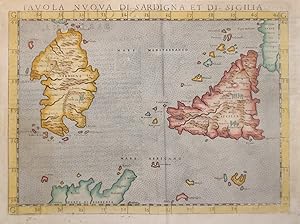
Tavola nuova di Sardigna et di Sicilia.
TOLOMEO CLAUDIO/RUSCELLI GIROLAMO.
From
libreria antiquaria perini Sas di Perini, Verona, VR, Italy
Seller rating 5 out of 5 stars
![]()
AbeBooks Seller since 18 September 2006
About this Item
Description:
Incisione in rame, colorata a mano, mm 190x263, tratta dall'edizione veneziana della "Geographia" curata da Ruscelli. Buon esemplare, con qualche minima piega. Nr.cat: P2060038. Seller Inventory # 7357
Bibliographic Details
Title: Tavola nuova di Sardigna et di Sicilia.
Publisher: Venezia
Publication Date: 1561
Top Search Results from the AbeBooks Marketplace
Tavola Nuova di Sardigna et di Sicilia
Seller: Argosy Book Store, ABAA, ILAB, New York, NY, U.S.A.
unbound. Map. Uncolored engraving. Image measures 7 1/2" x 10 1/4" This scarce 1564 map of Sicily, Sardinaa, and Malta from Girolamo Ruscelli's "La Geografia di Claudio Tolomeo Alessandrino" is one of the earliest earliest obtainable modern maps of Sicily, Sardinia, and Malta. Based on Giacomo Gastaldi's 1548 map, it depicts detailed topographical and geographical features, including cities, towns, ports, mountain ranges, rivers, and forested areas. Notable elements include an erupting Mount Etna on Sicily and a wild mountain goat in Sardinia. The map's depiction of these regions, including parts of the western coast of Italy and numerous smaller islands, showcases remarkable detail for the period. The map is in good condition with minor toning along the centerfold. Girolamo Ruscelli (1500-1566) was an Italian cartographer, humanist, scholar, and polymath from Viterbo. He was educated at the University of Padua and spent his career between Rome, Naples, and later Venice. Ruscelli was a prolific writer and editor, contributing to a wide array of subjects including Italian literature, medicine, alchemy, and military science. He is best known for his revision of Ptolemy's Geographia, published posthumously in 1574. His edition featured newly engraved maps based on those by Giacomo Gastaldi for the 1548 Venice atlas. These maps marked a significant advancement in cartography, reintroducing the use of copper engraving, which allowed for greater detail. Ruscelli's atlas editions, published multiple times between 1561 and 1599, were among the most comprehensive of their time and helped define the known geography of the world for decades. Seller Inventory # 322960
Quantity: 1 available
Tavola nuova di Sardigna et di Sicilia
Seller: libreria antiquaria perini Sas di Perini, Verona, VR, Italy
Incisione in rame, dipinta a mano, mm 190x263. Affascinante carta geografica raffigurante le isole di Sardegna e Sicilia secondo il modello Gastaldino.Tratta dall'edizione veneziana della "Geographia" di Tolomeo curata da Ruscelli. La carta Ë basata su quella di Gastaldi del 1548 pubblicata nella sua edizione della "Geografia" di qualche anno prima. Girolamo Ruscelli (1500-1566) nasce a Viterbo ed Ë un importante scrittore ed editore, che dopo aver studiato a Padova trascorse la propria carriera fra Roma e Napoli, dove morÏ.Tolomeo, il pi? grande cartografo dell'antichit?, pubblicÚ La Geografia nel 150 d.C.; nel medioevo sopravvisse, grazie alla mediazione araba, manoscritta in greco e fu poi tradotta in latino da Jacopo D'Angelo; da inizio Quattrocento acquisÏ sempre pi? notoriet? e nel 1477 fu pubblicata a Bologna la prima edizione illustrata a stampa comprendente solo carte del mondo antico, immediatamente seguita da altre edizioni nel 1478, -80, -82 che gi? presentavano alcune carte del mondo moderno. Con il susseguirsi delle edizioni, si incrementÚ il numero delle carte moderne consci che il mondo fosse ben diverso da quello di Tolomeo, fino a giungere alla celebre edizione del 1513 di Waldseemueller, il primo atlante moderno, composto da 20 carte nuove oltre alle antiche. Nel corso del XVI secolo ed oltre vennero poi editate numerose edizioni fra cui quelle curate da Ruscelli, le cui carte moderne sono quelle di Gastaldi del 1548 in versione ingrandita. Ottimo esemplare in bella coloritura nello stile tolemaico, con interessante e curioso testo descrittivo in italiano al verso. Nr.cat: p2060038. Seller Inventory # 13248
Quantity: 1 available
1574 Tavola Nuova Di Sardigna Et Di Sicilia
Seller: New World Cartographic, Chicago, IL, U.S.A.
By: Girolamo RuscelliDate: 1574 (published) VeniceDimensions: 7.4 x 10.4 inches (18.8 x 26.42 cm) plate sizeThis map is one of the earliest obtainable modern era maps of the region. It depicts Sicily, Sardinia and Malta along with a portion of the western coast of Italy and numerous smaller islands.This highly desirable Ruscelli map is from his work La Geografia di Claudio Tolomeo Alessandrino. Ruscelli based much of his work on that of Claudius Ptolemy and the atlas of Giacomo Gastaldi.The map is minutely detailed, and includes cities, towns and ports. An erupting Mount Etna on Sicily is pictorially represented, forested areas are clearly delineated, and what appears to be a wild mountain goat is featured in Sardinia. Mountain ranges and river systems are clearly defined.Girolamo Ruscelli (1500-1566) was an Italian cartographer, polymath, humanist and editor, active in Venice during the early 16th century. Ruscelli is best known for his important revision of Ptolemys Geographia, published posthumously in 1574.Claudius Ptolemy (85-165 CE), a Roman citizen of Greek descent from Alexandria, was the most influential of Greek astronomers and geographers of his time. He propounded the geocentric theory of the solar system which was to prevail for the next 1400 years.Giacomo Gastaldi (c.1500-1566) was an Italian astronomer, cartographer and engineer from Villafranca in Piedmont. Many of Ruscelli's maps are essentially enlarged versions of some of Gastaldi's maps.Condition: This map is in A condition. Well-inked, crisp impression. Italian text on the verso.Inventory #118041200 W. 35th Street #425 Chicago, IL 60609 | P: (312) 496 - 3622. Seller Inventory # tavola-nuova-di-sardigna-et-di-sicilia
Quantity: 1 available
Tavola nuova di Sardigna et di Sicilia
Seller: Libreria Ex Libris ALAI-ILAB/LILA member, Roma, Italy
Incisione originale su rame (cm. 26,5x19 più margini bianchi) tratta da 'La Geografia di Claudio Tolomeo'. Ottimo esemplare. Seller Inventory # 1444B
Quantity: 1 available

