
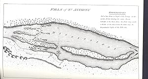
An account of expeditions to the sources of the Mississippi, and through the western parts of Louisiana, to the sources of the Arkansas, Kans, La Platte, and Pierre Juan, Rivers. Performed by order of the Government of the United Statos during the years 1805, 1806, and 1807, and a tour through the interior parts of New Spain, when conducted through these provinces, by order of the captain-general in the year 1807, by Major Z.M. Pike [ Great Americac series] [map1 [Falls of St. Anthony] -- map2 The first part of Capt'n Pike's chart of the internal part of Louisiana -- map3 A chart of the internal part of Louisiana -- map4 A map of the Internal Provinces of New Spain -- map5 A sketch of the Vice Royalty . -- map6 Map of the Mississippi Rive
Pike, Zebulon Montgomery, 1779-1813.
Published by New York : Readex Microprint, [Philadelphia, Published by C. & A. Conrad & Co. . etc., 1810.], 1966, 1966
Condition: Fine
Hardcover
From Joseph Valles - Books, Stockbridge, GA, U.S.A.
Seller rating 5 out of 5 stars
![]()
AbeBooks Seller since 17 August 1998