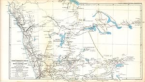
Western Australian Maps from Petermann's Geographical Journal published in "Mittheilungen aus Justus Perthes' Geographischer Anstalt," 9 maps from 1862-1881

Published by Augustus Petermann, Gotha, 1881

  • Softcover
  • Used
See all details
Item image 1 of 5.
Heritage seller

Seller: Antipodean Books, Maps & Prints, ABAA, Garrison, NY, U.S.A.Antipodean Books, Maps & Prints, ABAA

5-star seller

AbeBooks seller since September 17, 1998

Association member: ABAAESAANZAABILAB

Softcover

Condition: Used - Very good

£ 942.04

£ 7.56 shipping 
Ships within U.S.A.

Quantity: 1 available

Add to basket
Free 30-day returns

Item description from seller

A collection of nine maps of Australian exploration from Petermann's Journal, from 1862 to 1881. Augustus Petermann studied and worked with famous German and English cartographers in the 1840's, and eventually established his Geographical Journal in 1855, which is published to this day. Through his association with the Royal Geographical Society in London and later as the first head of the Geographical Institute in Gotha, he had extensive correspondence with a large number of explorers and travelers, who contributed the very latest information for the "Journal". His contacts from his R.G.S. days lead to many Australian explorations being reported in his "Journal" and nowhere else (eg. Lefroy 1864). The Petermann Ranges, in the west of South Australia, are named after him. Petermann's maps included much topographical and water system detail and were used to update such atlases as Stieler Hand Atlas. In 1869 Petermann encouraged the German push on the North Pole, organizing 2 expeditions. All maps are lithographs printed in color. [1862]. Provisorische Karte von Frank Gregory's reisen in Nordwest-Australien April bis June 1858 & Mai bis Oktober 1861. 9 3/4 x 8". WA from Sharks Bay to Cape Larry. (7) [1863]. Karte der Reise von C. & A. Dempster, Clarkson & Harper innern von West Australien Juli & August 1861. 17 x 10". From York to Lake Grace & Mt. Kennedy. Much detail of an expedition that was never published in English. (9) [1864]. Karte von H.M. Lefroy's Exploration innern von West-Australien Mai bis Juli 1863. 15 1/4 x 10". York to Mt. Robinson with Lake Moore in the top left corner. Never published in English. (10) [1869]. John Forrest's Reise im Innern von West-Australien April-Mai 1869. Nebst Ubersicht der Entdeckungen bis 1869. 17 x 10 1/2". Printed outline color. Perth to Murchison River inland to Hampton Plains and Lake Lefroy. Expedition routes include Forrest, AC Gregory, Dale, Austin, Roe, C & A Dempster, Moore, Lefroy & Robinson, F. Gregory, Hunt, Helpman. (20) [1874]. Vorlaufige Skizze von Gosse's & Warburton's Reisen durch West-Australien 1873-4 & Standpunkt der Geographischen Kenntniss dieses Gebietes in 1874. 10 1/2 x 13". Warburton's route from Perth to the overland telegraph, inset of Sydney. (24) [1874]. Thomas Elders' Expedition durch Inner-Australien von Beltana im Osten bis Perth im Western ausgefuhrt durch E. Giles Mai-Nov 1875. 26 x 10 1/2". SW Australia from Bunbury to Adelaide in the south, upper Murchison to north of Lake Eyre in the north. Very unusual projection, water and sea outlined in blue. (26) [1876]. Die Neuesten Entdeckung-reisen im Innern von Australien von Warburton Giles Forrest April 1873-Sept 74. 25 3/4 x 10". Sharks Bay to 90 Mile Beach over to Alice Springs. Much geographical detail on the inland exploration. (27) [1877]. Thomas Elders' Expedition durch Inner-Australien von Murchison im Westen, bis zum Neales im Osten, Ausgefuhrt durch E. Giles, April-Aug 1876. The map illustrates Ernest Giles 2nd expedition across Australia. The explorers' routes marked include Warburton, April 15, 1873 to January 26, 1874; Giles: August 1873 to June 1874; Forrest: April 22 to September 27, 1874. It shows Western Australia from Shark's Bay north to 80 Mile Beach, just beyond present site of Port Hedland and east to Mt. Browne in South Australia. The Petermann Ranges feature just into South Australia, named for the cartographer/publisher, Augustus Petermann. 26 x 10". [1881]. Nordwest-Australien und Timor Meer nach Alex Forrest's Forschungen 1879 und den Neuesten Nautischen Vemessumgen. 10 x 8". Outlines explorations by A. Forrest 1879; L. Leichhardt 1845; A. C. Gregory 1855-6; J. McD. Stuart 1862; J. McKinlay 1866; G. McMinn 1876; A. W. Sergison 1877; J. G. Brockman 1879-80. Map from south of Roebuck Bay -Coburg Peninsula. Towns and names in English, observations in German. (29).…

Seller Inventory # 22266

Bibliographic details

Title
Western Australian Maps from Petermann's Geographical Journal published in "Mittheilungen aus Justus Perthes' Geographischer Anstalt," 9 maps from 1862-1881
Author
Petermann, Augustus
Publisher
Augustus Petermann, Gotha
Publication year
1881
Condition
Very good condition
Binding
Soft cover
Seller catalogs
EXPLORATION, MAPS, WEST AUSTRALIA

Antipodean Books, Maps & Prints, ABAA

Garrison, NY, U.S.A.

5-star seller

AbeBooks seller since September 17, 1998

Association member:

Shipping rates within U.S.A.

Item5 to 14 business days3 to 6 business days
First item£ 7.56£ 9.30
Delivery times are set by sellers and vary by carrier and location. Orders passing through Customs may face delays and buyers are responsible for any associated duties or fees. Sellers may contact you regarding additional charges to cover any increased costs to ship your items.

Payment methods

  • Visa
  • Mastercard
  • American Express
  • Apple Pay
  • Google Pay
  • Bank Draft
  • Bank Wire Transfer
  • Cash
  • Check
  • Money Order

Store description

We have been booksellers for 50 years, members of the ABAA, ILAB & many prominent trade organizations. You may order from us with the security that an established & reputable bookseller offers you, who abides by the code of ethics established by ILAB. We offer old, rare & out of print books, maps, prints, ephemera & photographs on many subjects. We handle items in every fields. Some of our specialties include the Hudson River Valley, the Antarctic & Arctic, Australia & the South Pacific.

Specialty

Exploration, Polar, Australia, Voyages & Travel, Antarctic, Anthropology, South Pacific, Hudson River, Maps & Prints, Ephemera

Association member

  • Antiquarian Booksellers' Association of America
  • The Ephemera Society of America
  • The Australian and New Zealand Association of Antiquarian Booksellers
  • International League of Antiquarian Booksellers
Members of these associations are committed to maintaining the highest standards. They vouch for the authenticity of all items offered for sale. They provide expert and detailed descriptions, disclose all significant defects and/or restorations, provide clear and accurate pricing, and operate with fairness and honesty during the purchase experience.

Seller's business information

Antipodean Books, Maps & Prints, ABAA

29 Garrisons Landing
Garrison, NY U.S.A. 10524