![TABULA TERRE NOVE [THE ADMIRAL'S MAP]: [Waldseem�ller, Martin]](https://pictures.abebooks.com/inventory/31022019826.jpg)
![TABULA TERRE NOVE [THE ADMIRAL'S MAP]: [Waldseem�ller, Martin]](https://pictures.abebooks.com/inventory/31022019826_2.jpg)
![TABULA TERRE NOVE [THE ADMIRAL'S MAP]: [Waldseem�ller, Martin]](https://pictures.abebooks.com/inventory/31022019826_3.jpg)
TABULA TERRE NOVE [THE ADMIRAL'S MAP]
[Waldseem�ller, Martin]
Published by Johann Schott, [Strassburg, 1513
Used
From
William Reese Company - Americana, New Haven, CT, U.S.A.
Seller rating 4 out of 5 stars
![]()
AbeBooks Seller since 13 July 2006
About this Item
Description:
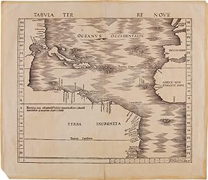
Woodblock map on two joined sheets. Overall joined sheet size: 18 1/4 x 20 3/4 inches. Evidence of previous mounting on outer margins (not touching text), light even tanning. Diagonal tear in lower left corner, with loss of paper (not affecting text). Very good. An excellent copy of the earliest obtainable printed map focusing on the western hemisphere. It is preceded only by Peter Martyr's map of the Spanish Main (Seville, 1511), and Johannes Stobnicza's 1512 map. This was the most important map featured in Johann Schott's edition of Claudius Ptolemy's GEOGRAPHIE OPUS NOVISSIMA TRADUCTIONE E GRECORUM ARCHETYPIS CASTIGATISSIME PRESSUM, the first modern atlas. This map depicts the eastern coast of North and South America in a continuous line from the northern latitude of 55� to Rio de Cananor at the southern latitude of 35� (approximately the Rio de la Plata), with about sixty places named. The notably blank interior of the continent is appropriately labeled "Terra Incognita." In the Caribbean, Cuba is identified as "Isabella," after Queen Isabella of Spain; Hispaniola is "Spagnolla"; and Puerto Rico is "Boriguem." Jamaica (Jamaiqua) is also featured, together with several smaller islands in the Caribbean and Bahamian archipelagos. North America is somewhat compressed, and includes a river named Caninor, quite possibly the St. Lawrence River. About twenty places are identified on the North American coastline, drawn primarily from Portuguese sources, including the Cantino Portolano PLANISPHERE (1502) and the Caverio map of the world (ca. 1505). The depiction of the Floridian peninsula and the curve of the coast of the Gulf of Mexico suggests that Waldseem�ller had access to reports from as-yet unrecorded voyages. The first recorded European contact with Florida was by Ponce de L�on's voyage, which was in 1513, the same year this map was printed; the first mapping of the Gulf was done during Alonso �lvarez de Pineda's voyage in 1517-19. The text printed near the northern coast of South America explains that the land and adjacent islands were discovered by Columbus: "Hec terra cum adiacentib[us] insulis inuenta est per Columbu[m] ianuensem ex mandato Regis Castelle" ("This land with its adjacent islands was discovered by Columbus, sent by the king of Castile"). Some scholars have suggested that this was Waldseem�ller's effort to correct his 1507 map, which credited Amerigo Vespucci with the discovery of America. Adding to further debate, Waldseem�ller notes the source of this map as "the Admiral," with some scholars asserting this must be Columbus, and others arguing that it refers to Amerigo Vespucci. Recent scholarship suggests that it may be from an inscription on the Caverio map noted above. Regardless, this map is central to the cartographic history of the Americas. Excepting the smaller edition of this map published by Laurent Fries in Lyon (1522), it was not until 1534 that another large-scale map of the Americas was published, by Giovanni Battista Ramusio. Martin Waldseem�ller (ca.1470-ca.1522) was one of the leading cartographers during the first great period of global exploration by European powers. He studied at the University of Freiburg, and then joined a group of humanist scholars based at the Abbey of St. Di� in Alsace. Waldseem�ller was inspired by Vespucci's work MUNDUS NOVUS, which argued for the first time that the "New World" was a distinct landmass. Accordingly, in 1507, Waldseem�ller published the first map, printed or in manuscript, to depict a separate Western Hemisphere, with the Pacific as a separate ocean (UNIVERSALIS COSMOGRAPHIA SECUNDUM PTHOLOMAEI TRADITIONEM.). This map clearly portrays the Americas as "the Fourth Part of the World," with a western coastline, showing it to be completely separate from Asia. This map was perhaps a bit too controversial at the time, and this TABULA TERRE NOVE, while still revolutionary, may have been his attempt to scale back the claims in the 1507 map. Here, Waldseem�l. Seller Inventory # WRCAM56425
Bibliographic Details
Title: TABULA TERRE NOVE [THE ADMIRAL'S MAP]
Publisher: Johann Schott, [Strassburg
Publication Date: 1513
Top Search Results from the AbeBooks Marketplace

TABULA TERRE NOVE [THE ADMIRAL'S MAP].
Published by
[Strassburg: Johann Schott, March 12, 1513]., 1513
Used
Seller: William Reese Company - Americana, New Haven, CT, U.S.A.
Seller rating 4 out of 5 stars
![]()
An excellent copy of the earliest obtainable printed map focusing on the western hemisphere. It is preceded only by Peter Martyr's map of the Spanish Main (Seville, 1511) and Johannes Stobnicza's 1512 map. This was the most important map featured in Johann Schott's edition of Claudius Ptolemy's GEOGRAPHIE OPUS NOVISSIMA TRADUCTIONE E GRECORUM ARCHETYPIS CASTIGATISSIME PRESSUM, the first modern atlas. This map depicts the eastern coast of North and South America in a continuous line from the northern latitude of 55� to Rio de Cananor at the southern latitude of 35� (approximately the Rio de la Plata), with about sixty places named. The notably blank interior of the continent is appropriately labeled "Terra Incognita." In the Caribbean, Cuba is identified as "Isabella," after Queen Isabella of Spain; Hispaniola is "Spagnolla"; and Puerto Rico is "Boriguem." Jamaica ("Jamaiqua") is also featured, together with several smaller islands in the Caribbean and Bahamian archipelagos. North America is somewhat compressed, and includes a river named Caninor, quite possibly the St. Lawrence River. About twenty places are identified on the North American coastline, drawn primarily from Portuguese sources, including the Cantino Portolano PLANISPHERE (1502) and the Caverio map of the world (ca. 1505). The depiction of the Floridian peninsula and the curve of the coast of the Gulf of Mexico suggests that Waldseem�ller had access to reports from as-yet unrecorded voyages. The first recorded European contact with Florida was by Ponce de L�on's voyage, which was in 1513, the same year this map was printed; the first mapping of the Gulf was done during Alonso �lvarez de Pineda's voyage in 1517-19. The text printed near the northern coast of South America explains that the land and adjacent islands were discovered by Columbus: "Hec terra cum adiacentib[us] insulis inuenta est per Columbu[m] ianuensem ex mandato Regis Castelle" ("This land with its adjacent islands was discovered by Columbus, sent by the king of Castile"). Some scholars have suggested that this was Waldseem�ller's effort to correct his 1507 map, which credited Amerigo Vespucci with the discovery of America. Adding to further debate, Waldseem�ller notes the source of this map as "the Admiral," with some scholars asserting this must be Columbus, and others arguing that it refers to Amerigo Vespucci. Recent scholarship suggests that it may be from an inscription on the Caverio map noted above. Regardless, this map is central to the cartographic history of the Americas. Excepting the smaller edition of this map published by Laurent Fries in Lyon (1522), it was not until 1534 that another large-scale map of the Americas was published, by Giovanni Battista Ramusio. Martin Waldseem�ller (ca. 1470 - ca. 1522) was one of the leading cartographers during the first great period of global exploration by European powers. He studied at the University of Freiburg, and then joined a group of humanist scholars based at the Abbey of St. Di� in Alsace. Waldseem�ller was inspired by Vespucci's MUNDUS NOVUS, which argued for the first time that the "New World" was a distinct landmass. Accordingly, in 1507, Waldseem�ller published the first map, printed or in manuscript, to depict a separate Western Hemisphere, with the Pacific as a separate ocean (UNIVERSALIS COSMOGRAPHIA SECUNDUM PTHOLOMAEI TRADITIONEM.). This map clearly portrays the Americas as "the Fourth Part of the World," with a western coastline, showing it to be completely separate from Asia. This map was perhaps a bit too controversial at the time, and this TABULA TERRE NOVE, while still revolutionary, may have been his attempt to scale back the claims in the 1507 map. Here, Waldseem�ller does not show a western coastline, leaving the possibility of the Americas as a separate landmass to be ambiguous. The label "America" is also absent, and credit for discovery is given solely to Columbus. In spite of this, "America" was utilized by Mercator i. Seller Inventory # 56425
Quantity: 1 available