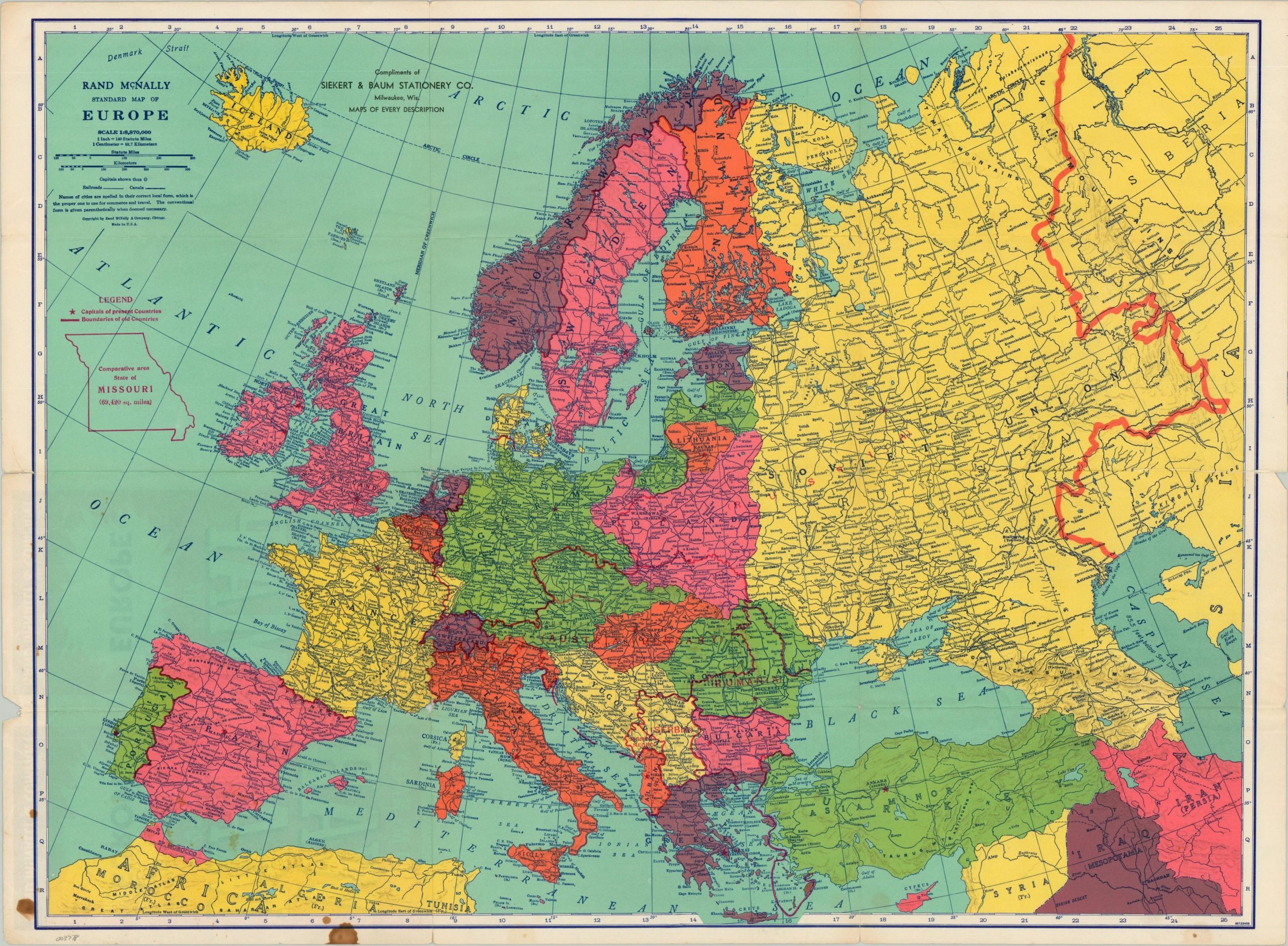
Rand McNally War Map of Europe - An interesting map showing the outbreak of World War II in Europe.
Rand McNally
Published by c. 1939, 1939
Used
From
Curtis Wright Maps, Berwyn, IL, U.S.A.
Seller rating 5 out of 5 stars
![]()
AbeBooks Seller since 15 February 2023
This book is no longer available. AbeBooks has millions of books. Please enter search terms below to find similar copies.
About this Item
Description:
This boldly colored map of Europe was published in Chicago by Rand McNally in 1939, shortly after the German invasion of Poland and subsequent declaration of war by France and Britain. Political borders are shaded with vibrant hues and, notably, the territory of the Third Reich includes Austria and the Czech Republic. Also of interest are the former borders of obsolete states like Austria-Hungary shown in red - perhaps a reflection on potential war aims? Last, but not least, an outline of the state of Missouri is provided in the upper left to allow the (largely American) audience to have a better comprehension of the distances involved across the theater. Sheet Width (in) 26.4 Sheet Height (in) 19.4 Condition Description "Creased and lightly worn along former fold lines. About 3" of separation has been repaired on the verso with archival tape and there's a few scattered stains in the lower left.". Seller Inventory # 3778
Bibliographic Details
Title: Rand McNally War Map of Europe - An ...
Publisher: c. 1939
Publication Date: 1939
Condition: Very Good
AbeBooks offers millions of new, used, rare and out-of-print books, as well as cheap textbooks from thousands of booksellers around the world. Shopping on AbeBooks is easy, safe and 100% secure - search for your book, purchase a copy via our secure checkout and the bookseller ships it straight to you.
Search thousands of booksellers selling millions of new & used books
New & Used Books

New and used copies of new releases, best sellers and award winners. Save money with our huge selection.
Rare & Out of Print Books
From scarce first editions to sought-after signatures, find an array of rare, valuable and highly collectible books.