
RAND, McNALLY & Co.'S NEW SECTIONAL MAP OF SOUTH DAKOTA
[South Dakota]: [Rand, McNally & Co.]
Published by Chicago, 1889
Used
From
William Reese Company - Americana, New Haven, CT, U.S.A.
Seller rating 4 out of 5 stars
![]()
AbeBooks Seller since 13 July 2006
This specific copy is no longer available. Here are our closest matches for RAND, McNALLY & Co.'S NEW SECTIONAL MAP OF SOUTH DAKOTA by [South Dakota]: [Rand, McNally & Co.].
About this Item
Description:
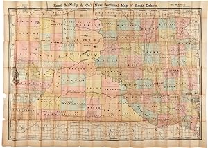
Colored folding map, 36 1/4 x 51 inches. Closed splits along several folds, but with no loss in map image. Two tears in left margin, with some paper loss. Good overall. One of the first maps of South Dakota published after it became a state in 1889. This is a handsome large folding map, with the eastern portions and the Black Hills region highly subdivided. The region west of the Missouri is quite open, with many Indian agencies located, including Standing Rock, the Cheyenne Agency, the Lower Brule Agency, the Rosebud Agency, and the Pine Ridge Agency. The location of Fort Randall on the Missouri is shown, and a long narrow vertical strip in the north central portion of the state is identified as "not in any county." This map is copyrighted 1889 but dated 1890 in the upper left margin. The scale is eight miles to the inch. An impressive South Dakota state map. CHECKLIST OF PRINTED MAPS OF THE MIDDLE WEST TO 1900, NORTH DAKOTA AND SOUTH DAKOTA, 11 0638. Seller Inventory # WRCAM46851
Bibliographic Details
Title: RAND, McNALLY & Co.'S NEW SECTIONAL MAP OF ...
Publisher: Chicago
Publication Date: 1889
Top Search Results from the AbeBooks Marketplace

Seller Image
RAND, McNALLY & Co.'S NEW SECTIONAL MAP OF SOUTH DAKOTA.
Published by
Chicago. 1889., 1889
Used
Seller: William Reese Company - Americana, New Haven, CT, U.S.A.
Seller rating 4 out of 5 stars
![]()
One of the first maps of South Dakota published after it became a state in 1889. This is a handsome large folding map, with the eastern portions and the Black Hills region highly subdivided. The region west of the Missouri is quite open, with many Indian agencies located, including Standing Rock, the Cheyenne Agency, the Lower Brule Agency, the Rosebud Agency, and the Pine Ridge Agency. The location of Fort Randall on the Missouri is shown, and a long narrow vertical strip in the north central portion of the state is identified as "not in any county." This map is copyrighted 1889 but dated 1890 in the upper left margin. The scale is eight miles to the inch. An impressive South Dakota state map. CHECKLIST OF PRINTED MAPS OF THE MIDDLE WEST TO 1900, NORTH DAKOTA AND SOUTH DAKOTA, 11 0638. Colored folding map, 36� x 51 inches. Closed splits along several folds, but with no loss in map image. Two tears in left margin, with some paper loss. Good overall. Seller Inventory # 46851
Quantity: 1 available