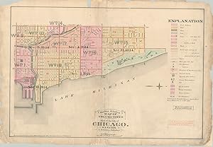
About this Item
This well-used map of Chicago's lakefront between the river and Lincoln Park was published in response to the devastating fire that rampaged through the city between October 8-10, 1871. Elisha Robinson, it's creator, was one of the numerous publishers who issued atlases specifically for the fire insurance industry. In order to properly assess risk, insurers needed information on building size, construction material, and the availability of water. Surveys were painstakingly performed, usually on foot, and the results are among the most complete snapshots of the city's physical makeup in the late 19th and early 20th centuries. This map was issued in Volume III of Robinson's Atlas of the City of Chicago in 1886 and served as a key and index to the rest of the tome. Though it shows a few individual details such as City Hall, the Water Works, railroads, and ward numbers, the information presented is a broad generalization when compared to each page of the atlas. As noted on the right side, the maps, in theory, outline every single building that existed at the time of publication. Though the blocks on the index are colored generically, individual footprints would be tinted according to their construction materials. Water lines, street elevation (which affects the flow), fire hydrants, and cisterns are also all noted. Sheet Width (in) 32.5 Sheet Height (in) 22.4 Condition Description Old and brittle paper formerly torn completely in several places and chipped in the corners. Repaired a number of times over the years, most recently with archival tape in numerous areas on the verso. Heavily soiled, with paper missing in several areas around the edges of the sheet.
Seller Inventory # C009116
Contact seller
Report this item