Synopsis:
When Oxford's Atlas of the World appeared last year, it was widely praised for the incredible beauty and accuracy of its maps and for its wealth of geographical information.Booklist hailed it as "one of the most current atlases available today" and singled out its "well-designed format and superior use of map colors." And John Noble Wilford, writing inThe New York Times Book Review, called it a veritable encyclopedia of geographic information, underscoring its "greater variety of maps and the inclusion of so much noncartographic information" and adding that "those old staples of geography textbooks--fossil fuel reserves, steel production, literacy standings--never looked more inviting of further study."
But world politics has been especially volatile in recent years, producing numerous changes to the face of the globe. To bring ourAtlas of the World completely up to date, Oxford now announces a new Second Edition, with dozens of significant alterations to the maps of Europe, Africa, South America, and the Middle East. For instance, theAtlas now shows the Slovak Republic, the Czech Republic, Bosnia-Herzegovina, and Macedonia; it redraws the boundary between Saudia Arabia and Iraq; and it displays new administrative divisions in Nigeria. The new maps also reveal extensive updating of finer details such as the latest Trans-Amazonian highways, a new reservoir south of Bamako, Mali, and the Guri Reservoir in Venezuela. And the index has been completely revised to reflect all these changes.
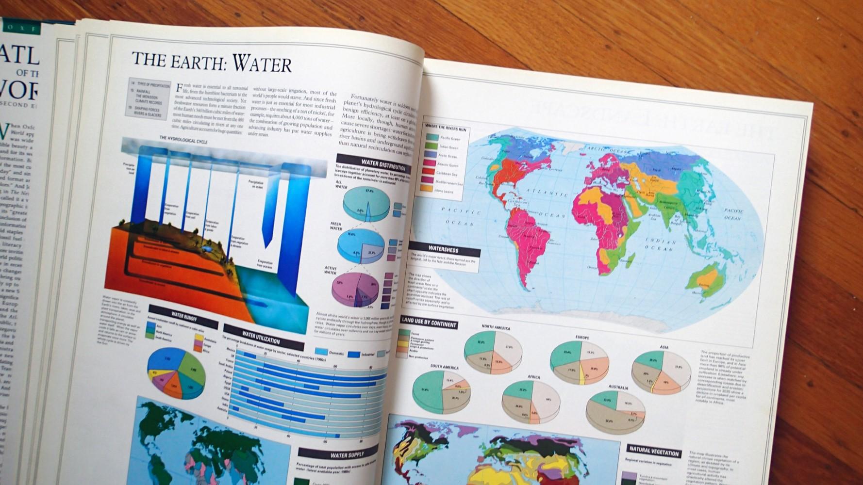
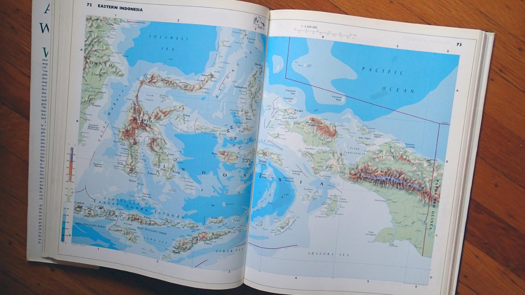
Of course, the basic qualities of the Atlas--the exquisite mapmaking and the wealth of supplemental information--are as superb as ever. As in the original edition, readers will find hundreds of outstanding, full-color maps produced by Europe's finest cartographers, George Philip Ltd. The heart of the book is the 160-page section of large-scale world maps, providing detailed political and topographical information about every nation on Earth, enhanced by relief shading and layer-colored contours. There are also 66 city maps charting the key urban centers of each continent. The 75,000-entry index offers easy, convenient access to specific locations, with full geographical coordinates and a convenient number-letter access system. And the stunning 48-page Introduction to World Geography section--beautifully illustrated with lavish color maps, graphs, and diagrams--offers a systematic look at world geography, covering topics such as climate, the greenhouse effect, plate tectonics, agriculture, health, population and migration, international organizations, global conflicts, and much more.
Exquisitely designed, thoroughly updated, and packed with informative articles, graphs, and charts, Oxford'sAtlas of the World offers the finest global coverage available. It is the benchmark by which all other international map references will be measured.
Review:
"An indispensable reference." --The Today Show
"A veritable encyclopedia of geographic and demographic information, profusely illustrated... Extraordinary." --The New York Times
"This authoritative volume is the standard by which others will be measured." --Boston Herald
"You can't do better than the Atlas of the World." --Chicago Tribune
"A page-turning stroll through the continents." --USA Today
"An indispensable reference." --The Today Show
"A veritable encyclopedia of geographic and demographic information, profusely illustrated... Extraordinary." --
The New York Times"This authoritative volume is the standard by which others will be measured." --
Boston Herald"You can't do better than the
Atlas of the World." --
Chicago Tribune"A page-turning stroll through the continents." --
USA Today"Flipping through this book is a lush experience, with new satellite imagery and more maps and graphs than you thought imaginable. Reading the Atlas is a little trip around the globe." --Kirkus
"The
Oxford Atlas of the World includes, beyond the meticulously detailed topography of every surface on the globe, useful maps of nearly 70 major city centers as well as efficient mini-essays on everything from slums to the global scrap-metal industry. Among 17 beautiful satellite images of population centers, those of Beijing, with its concentric roads encircling the Forbidden City, and Honolulu, a city built atop an undersea volcano, invite the sustained attention we reserve for great works of art." --
The Wall Street Journal"About this title" may belong to another edition of this title.


