


A NEW UNIVERSAL ATLAS CONTAINING MAPS OF THE VARIOUS EMPIRES, KINGDOMS, STATES AND REPUBLICS OF THE WORLD. WITH A SPECIAL MAP OF EACH OF THE UNITED STATES, PLANS OF CITIES, &c
[Mitchell, S. Augustus]
Published by Thomas, Cowperthwait & Co., Philadelphia, 1852
Used
From
William Reese Company - Americana, New Haven, CT, U.S.A.
Seller rating 4 out of 5 stars
![]()
AbeBooks Seller since 13 July 2006
About this Item
Description:
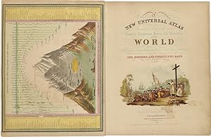
Chromolithographic title with large vignette; handcolored frontispiece of heights of principal mountains and lengths of principal rivers; contents list printed in red, black, and gold; seventy-three handcolored lithographic maps, charts, and city plans (one double-page). Folio. Publisher's three-quarter red morocco and marbled boards, spine ruled in gilt, morocco label lettered in gilt on front board. Binding worn and rubbed, front hinge tender. Contemporary bookplate on front pastedown. Some toning but generally clean internally. Very good overall. A famous atlas, with handcolored maps of all the individual states and territories, with the map of California showing counties in California and New Mexico for the first time, and with the locations of Native American tribes shown in several western states and territories. Despite its title, the atlas concentrates to a marked degree on the American continent, with forty-three maps of the area, including a fine double-page coast- to-coast map of the United States. S. Augustus Mitchell and his sons were the leading publishers of maps in the United States during most of the 19th century. Mitchell had come to Philadelphia round 1830 with the intention of improving the standard of geography textbooks, Philadelphia then being the leading city in America for cartographical publications. A NEW AMERICAN ATLAS, published in 1831, was his first work. In 1845 he acquired the right to Tanner's NEW UNIVERSAL ATLAS (first published in 1836), and in 1846 he published his first edition of the present work. Mitchell continued to publish the atlas until 1850, when he sold the copyright to Cowperthwait & Co. of Philadelphia. Thomas, Cowperthwait & Company published it until 1856, when it was purchased by Charles DeSilver. The Cowperthwait company continued to add, edit, alter, and hand-color the maps. PHILLIPS ATLASES 807. RISTOW, pp.311-13 (ref). RUMSEY 553. Seller Inventory # WRCAM31820A
Bibliographic Details
Title: A NEW UNIVERSAL ATLAS CONTAINING MAPS OF THE...
Publisher: Thomas, Cowperthwait & Co., Philadelphia
Publication Date: 1852
Top Search Results from the AbeBooks Marketplace

New Universal Atlas of the World Containing Maps of the various Empires, Kingdoms, States and Republics Of The World. With a special map of each of the United States, Plans of Cities &c. Comprehended in seventy sheets and forming a series of One Hundred And Seventeen Maps, Plans And Sections
Published by
Cowperthwait & Co, Philadelphia, 1852
Used
Hardcover
Seller: Heritage Book Shop, ABAA, Beverly Hills, CA, U.S.A.
Seller rating 5 out of 5 stars
![]()
Complete with seventy-three full colored maps, one of which is double-paged, color frontispiece, vignette title-page and table of contents, heightened in gilt. Folio (17 x 14 inches; 430 x 355 mm). Half red morocco over marbled boards. Front board with red morocco label, lettered in gilt. Binding scuffed and bumped. Hinges professionally repaired. Some toning throughout, mainly to blank versos of maps and margin edges, only occasionally affecting the maps. Closed tear to front free endpaper. A few instances of foxing on maps, mainly to map 51 "Holland and Belgium." A small dark spot in Buenos Ayres on map 44. A small piece scraped off of map 73, "Oceana" but not making a hole all the way through. Also a marginal closed tear to this map, professionally repaired. Overall a very good copy. This atlas was first published in 1846 by Mitchell & Sons after acquiring the rights to Tanner's New Universal Atlas in 1845. Mitchell & Sons reprinted it several times until 1850 when they sold the rights to Cowperthwait & Co. of Philadelphia, who published it until 1856. During this time the atlas was further expanded and edited. Over half of this atlas deals with the Americas and features the double-page "A New Map of the United States of America." Within this map of the USA is a detailed inset of "The Gold Regions of California." The present edition is the first to show counties in California and New Mexico. Howes. Streeter. HBS 65704. $7,500. Seller Inventory # 65704
Quantity: 1 available
A NEW UNIVERSAL ATLAS CONTAINING MAPS OF THE VARIOUS EMPIRES, KINGDOMS, STATES AND REPUBLICS OF THE WORLD. WITH A SPECIAL MAP OF EACH OF THE UNITED STATES, PLANS OF CITIES, &c.
Published by
Philadelphia: Thomas, Cowperthwait & Co., 1852., 1852
Used
Seller: William Reese Company - Americana, New Haven, CT, U.S.A.
Seller rating 4 out of 5 stars
![]()
A famous atlas, with handcolored maps of all the individual states and territories, with the map of California showing counties in California and New Mexico for the first time, and with the locations of Native American tribes shown in several western states and territories. Despite its title, the atlas concentrates to a marked degree on the American continent, with forty-three maps of the area, including a fine double-page coast-to-coast map of the United States. S. Augustus Mitchell and his sons were the leading publishers of maps in the United States during most of the 19th century. Mitchell had come to Philadelphia round 1830 with the intention of improving the standard of geography textbooks, Philadelphia then being the leading city in America for cartographical publications. A NEW AMERICAN ATLAS, published in 1831, was his first work. In 1845 he acquired the right to Tanner's NEW UNIVERSAL ATLAS (first published in 1836), and in 1846 he published his first edition of the present work. Mitchell continued to publish the atlas until 1850, when he sold the copyright to Cowperthwait & Co. of Philadelphia. Thomas, Cowperthwait & Company published it until 1856, when it was purchased by Charles DeSilver. The Cowperthwait company continued to add, edit, alter, and hand-color the maps. PHILLIPS ATLASES 807. RISTOW, pp.311-13 (ref). RUMSEY 553. Chromolithographic title with large vignette; handcolored frontispiece of heights of principal mountains and lengths of principal rivers; contents list printed in red, black, and gold; seventy-three handcolored lithographic maps, charts, and city plans (one double-page). Folio. Publisher's three-quarter red morocco and marbled boards, spine ruled in gilt, morocco label lettered in gilt on front board. Binding worn and rubbed, front hinge tender. Contemporary bookplate on front pastedown. Some toning but generally clean internally. Very good overall. Seller Inventory # 58409
Quantity: 1 available