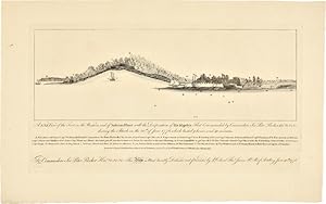
A N.b.E. VIEW OF THE FORT ON THE WESTERN END OF SULIVANS ISLAND WITH THE DISPOSITION OF HIS MAJESTY'S FLEET COMMODORE SIR PETER PARKER Knt. &c. &c. &c. DURING THE ATTACK ON THE 28th OF JUNE 1776. WHICH LASTED 9 HOURS AND 40 MINUTES
[Charleston, South Carolina]
From
William Reese Company - Americana, New Haven, CT, U.S.A.
Seller rating 3 out of 5 stars
![]()
AbeBooks Seller since 13 July 2006
About this Item
Description:
Engraving, 12 x 19 1/2 inches. Small old ink stamp on verso. Near fine. A profile view of Sullivan's Island, the main fort guarding the mouth of the Charleston harbor, with a key indicating the main features, ship locations, and gun emplacements. Below the view is a separate plate-mark with an engraved dedication, "To Commodore Sir Peter Parker Knt. &c. &c. &c. This View is most humbly dedicated and presented by Lt. Colonel Thos. James Rl. Rt. of Artillery June 30th, 1776." In the spring of 1776, South Carolina was in the firm possession of the American patriots, which the British were determined to challenge. They dispatched a fleet of twenty ships under Commodore Peter Parker, with the mission under the overall command of Major General Sir Henry Clinton. The ships moored in Five Fathom Hole, and landed on Long Island, which lay to the north of Sullivan's Island. Meanwhile, practical considerations indicated that the Patriot defenders were in considerable trouble. Led by Col. William Moultrie, the Americans were short of experienced troops and ammunition. Fort Sullivan, located on the southern tip of the island of the same name, had to be held, otherwise Charleston would fall. While the elegant plan of the fort, located in the inset at the upper left of the map, makes it appear to be a well designed bastion, it was in reality cobbled together with palmetto logs. Moultrie had a total of 1,125 men against 2,900 British marines. More worryingly, the fort had only twenty-six guns, with only twenty-eight rounds of ammunition per gun against the British fleet's 270 well stocked cannon. Fortunately for the Americans, the British proceeded to make a series of strategic errors. Clinton, who relied on information given by harbor pilots who were press-ganged into service, spent days looking for a non-existent ford between Long and Sullivan's Island, which in reality was prevented by the presence of a seven-foot deep channel. This bought the Americans time, allowing Col. William Thomson to fortify the northern tip of the island. On June 28th, the British mounted their full on naval assault of the fort. Moultrie wisely rationed and synchronized the use of his limited firepower, so that the British met heavier than expected resistance. Unfamiliar with the tidal shoals that lay near the fort, the British ships were unable to sail in close enough to the fort to deliver lethal blows, while remaining in range of the American guns. Amazingly, many of the British rounds which did strike the fort were harmlessly absorbed into the structure's spongy palmetto logs. The British flagship H.M.S. Bristol took heavy losses, and another ship ran aground and had to be abandoned. Another British attempt to storm Thomson's northern positions with a raid by long boats was easily repelled. The British were forced to completely withdraw, and promptly set sail for New York. A handsome view of this important battle, in beautiful condition, by Faden, who produced so many of the most important Revolutionary War maps in the next several years. CRESSWELL 606. Seller Inventory # WRCAM47959
Bibliographic Details
Title: A N.b.E. VIEW OF THE FORT ON THE WESTERN END...
Publisher: William Faden, London
Publication Date: 1776
AbeBooks offers millions of new, used, rare and out-of-print books, as well as cheap textbooks from thousands of booksellers around the world. Shopping on AbeBooks is easy, safe and 100% secure - search for your book, purchase a copy via our secure checkout and the bookseller ships it straight to you.
Search thousands of booksellers selling millions of new & used books
New & Used Books
New and used copies of new releases, best sellers and award winners. Save money with our huge selection.
Rare & Out of Print Books
From scarce first editions to sought-after signatures, find an array of rare, valuable and highly collectible books.


