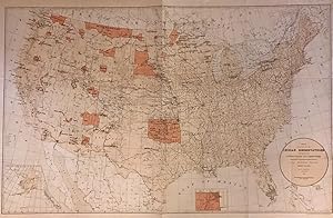
Map showing the location of the Indian Reservations within the limits of the United States and Territories
PRICE, Hiram
From
Argosy Book Store, ABAA, ILAB, New York, NY, U.S.A.
Seller rating 5 out of 5 stars
![]()
Heritage Bookseller
AbeBooks member since 1996
About this Item
Description:
Map. Color lithograph. Sheet measures 23.25" x 34.5". This large 1884 map presents the Indian Reservation in the United States and its territories. It covers the entire United States, with Alaska as an inset in lower left. Another inset shows the Indian Territory in northwest Oklahoma. The map identifies Indian Reservations and names. Military stations, Indian agencies, towns, villages, cities, railroads, rivers, mountains, and other topographic features are also noted. Compiled under the direction of Hon. Hiram Price, Commissioner of Indian Affairs. The map was issued by the Department of the Interior. In good condition with wear along the original folds. Margins show damage with some verso repairs. Seller Inventory # 272708
Bibliographic Details
Title: Map showing the location of the Indian ...
Publisher: Department of the Interior, Washington
Publication Date: 1888
Binding: unbound
AbeBooks offers millions of new, used, rare and out-of-print books, as well as cheap textbooks from thousands of booksellers around the world. Shopping on AbeBooks is easy, safe and 100% secure - search for your book, purchase a copy via our secure checkout and the bookseller ships it straight to you.
Search thousands of booksellers selling millions of new & used books
New & Used Books
New and used copies of new releases, best sellers and award winners. Save money with our huge selection.
Rare & Out of Print Books
From scarce first editions to sought-after signatures, find an array of rare, valuable and highly collectible books.


