About this Item
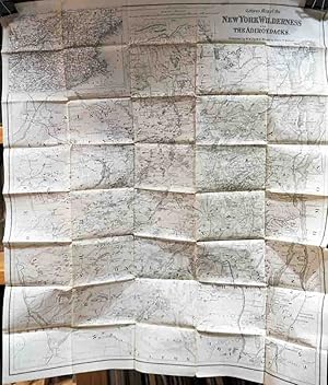
Uncolored folding map of the Adirondack region of New York State (all or parts of Saratoga, Warren, Washington, Fulton, Herkimer, Hamilton, Lewis, St. Lawrence, Essex, Oneida, Clinton and Franklin Counties) in excellent condition. Inset map of New England and New York State at upper left. The source of this particular map are unclear, as there is no evidence of attachment to a folder or binding into a book or pamphlet. Shows all of Lake Champlain and Lake George. This is a later issue of Ely's map of the region, first published in 1869 and reissued in reduced format, of which this is an example, into the 1890's. Along with an 1881 publication date, this copy also has an 1881 copyright date. This was a very popular map which identified, with heights, most of the mountains and higher hills in this region. Seller Inventory # m01774
Contact seller
Report this item
