


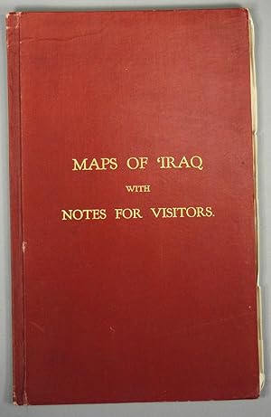
MAPS OF IRAQ WITH NOTES FOR VISITORS
Goverment of IRaq
Publication Date: 1929
Used
From
Boston Book Company, Inc. ABAA, Boston, MA, U.S.A.
Seller rating 2 out of 5 stars
![]()
AbeBooks Seller since 3 February 1997
This specific copy is no longer available. Here are our closest matches for MAPS OF IRAQ WITH NOTES FOR VISITORS.
About this Item
Description:
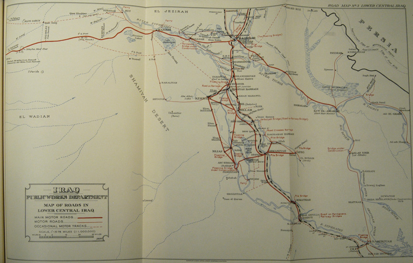
Goverment of Iraq. MAPS OF IRAQ WITH NOTES FOR VISITORS. Baghdad, London: Goverment of Iraq, 1929. REvised and Enlarded Edition, 1929. Folio. 34pp. Bound in original maroon cloth with gilt lettering to front cover. 8 large folding maps, all required. All printed in 3 colors and produced by the Public Words Department of Iraq. 6th map has one fold with small tears and creases at edges. Head and tail are slightly worn. Includes photo-illustrated frontispiece. Seller Inventory # 86709
Bibliographic Details
Title: MAPS OF IRAQ WITH NOTES FOR VISITORS
Publication Date: 1929
Top Search Results from the AbeBooks Marketplace

Maps of 'Iraq with Notes for Visitors.
Published by
London, (Waterlow & Sons for) the Government of 'Iraq, 1929., 1929
Used
Hardcover
Seller: Antiquariat INLIBRIS Gilhofer Nfg. GmbH, Vienna, A, Austria
Seller rating 5 out of 5 stars
![]()
Folio (215 x 344 mm). (4), 34 pp. With a photographic frontispiece showing the Arch of Ctesiphon and 9 folding maps. Original red cloth, lettered in gilt. Revised and enlarged edition: an excellent guide to the roads of Iraq, with notes compiled by government departments and members of commercial firms. The text contains chapters on the "Development of Oil Resources", "The Great Tribes of Iraq", and "The Iraq Police", and offers advice on roads and railways, the Iraq Automobile Association, "Government Regulations for Ladies Travelling in Iraq", and other information on history, culture and political organization of the country. The front pastedown bears a binder's ticket advising the owner that "the solution used in binding this book has been specially prepared in order to render the work impervious to the ravages of insects". - Ink ownership, dated Baghdad, 1934, to pastedown. Extremities slightly rubbed, otherwise very good. Seller Inventory # 51275
Quantity: 1 available

Maps of Iraq with Notes for Visitors
Published by
Baghdad and London: Government of Iraq, 1929
Used
Hardcover
Seller: Philip Salmon & Co. Rare Books, Boston, MA, U.S.A.
Seller rating 5 out of 5 stars
![]()
Hardcover. Condition: Near fine. Quarto. 34pp + 8 fold-out maps printed in three colors. A significant document recording the cartographical intervention of the British government in the affairs and perceptions of its then-colony. The relationship never stabilized (as much as any imperial claim can be said to do so), and in 1932 Iraq would become independent. But here in 1929, the governments of Britain and Iraq attempt to frame the Middle Eastern nation as an appealing historical landmark and even a casual tourist destination. Among the fold-outs are several road maps, a city� map of Baghdad, and a map of all the ancient sites presumably of interest (e.g. Babylon, Ur, and Seleucia). The controlling exertions of the colonial power are most overt at the fifth map for "Trans-Desert Routes," where an outline of England is provided "for scale." Though the foreword declares the contrary - the notes "should not be regarded as necessarily containing the views of the Ministries of the Government - the tables of northern and southern "tours" and a nod to consumer air travel proves the opposite. Bound in red cloth over boards with gilt titling at upper cover. Modest edge rubs and bumps, some creasing to sixth map, which overlaps fore-edge, else near fine. Unrecorded in OCLC. Seller Inventory # 1721
Quantity: 1 available
Maps of 'Iraq with Notes for Visitors.
Published by
Baghdad & London, Government of 'Iraq, 1929., 1929
Used
Hardcover
Seller: Antiquariat INLIBRIS Gilhofer Nfg. GmbH, Vienna, A, Austria
Seller rating 5 out of 5 stars
![]()
Folio (215 x 343 mm). 34 pp. With 8 folding maps printed in red, blue, and black, and a photographic frontispiece. Original red cloth titled in gilt. Eight handsome maps of Iraq published in a volume alongside information on the region gathered by the British after WWI, including climate, geography, the tribes of Iraq, and ancient sites, as well as information on passports, consulates, coinage, the police and army, the "Development of Oil Resources," and "Government Regulations for Ladies Travelling in 'Iraq" aimed at the influx of European visitors and business interests in the interwar period. The maps show Iraqi highways for the prospective motorist, the cities of Baghdad and Basra, ancient sites, and trans-desert routes. Here published in a revised and enlarged edition. - Previously owned by the famous American archaeologist Richard Francis Strong Starr (1900-94), as indicated by an ownership inscription reading "R. F. S. Starr" on the front free endpaper. Starr was a member of the initial Harvard-Baghdad School dig at Nuzi (also known as Yorghan Tepe), near Kirkuk in Iraq, and was director of operations there from 1929 to 1931. Among other findings, this expedition uncovered thousands of cuneiform tablets associated with the Horites, an ancient people mentioned in Biblical texts but previously unknown to archeology. The site at Nuzi appears on the map of ancient sites in this volume. - The Kingdom of Iraq under British Administration, or Mandatory Iraq, existed between 1921 and 1932, after Iraqi nationalist pressure pushed back against the proposed British Mandate of Mesopotamia. During the postwar phase in which Britain had large colonial Mandates in the Middle East, tourism became increasingly popular, and such publications came into demand. - This is a particularly good copy with all of its maps intact and in good condition, with only slight signs of wear. Seller Inventory # 61384
Quantity: 1 available
Maps of Iraq with notes for visitors.
Published by
Government of Iraq, 1929
Used
Hardcover
Seller: Shapero Rare Books, London, United Kingdom
Seller rating 4 out of 5 stars
![]()
Revised and enlarged edition. Folio (34.5 x 21.5 cm. approx.), [iv], 34pp., photographic frontispiece, 8 folding maps coloured in outline, scale 1 inch = 15.78 miles (1: 1000,00), original red cloth lettered in gilt on upper cover, a very good copy. Maps include Baghdad and Environs, The Environs of Basrah and several road maps to Southern and Northern Iraq. Seller Inventory # 112648
Quantity: 1 available