


MAPS OF THE DISTRICT OF COLUMBIA AND CITY OF WASHINGTON, AND PLATS OF THE SQUARES AND LOTS OF THE CITY OF WASHINGTON. PRINTED IN PURSUANCE OF A RESOLUTION OF THE SENATE OF THE UNITED STATES
[District of Columbia]
Published by Printed by A. Boyd Hamilton, Washington, 1852
Used
From
William Reese Company - Americana, New Haven, CT, U.S.A.
Seller rating 4 out of 5 stars
![]()
AbeBooks Seller since 13 July 2006
This specific copy is no longer available. Here are our closest matches for MAPS OF THE DISTRICT OF COLUMBIA AND CITY OF WASHINGTON, AND PLATS OF THE SQUARES AND LOTS OF THE CITY OF WASHINGTON. PRINTED IN PURSUANCE OF A RESOLUTION OF THE SENATE OF THE UNITED STATES by [District of Columbia].
About this Item
Description:
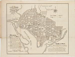
Titlepage followed by 159 leaves printed on recto only, plus three folding maps. Folio. Modern three-quarter calf, marbled boards. Largest of the folding maps with a small mended tear and a few edge tears, but with no loss. Very good. A remarkable cartographic study of Washington, D.C. in the decade before the Civil War. The folding maps show, respectively, the "Territory of Columbia"; "Plan of the City of Washington in the Territory of Columbia.," a very detailed rendering of the streets and blocks designated by number, with "Observations explanatory of the Plan" and a long note regarding the "Breadth of the Streets"; and a larger, even more detailed map of the city with a list of special attractions referenced on the map. This map was engraved by W.J. Stone and is based on Andrew Ellicott's earlier map of the District. The 159 numbered leaves of the book, printed on the rectos only, correspond to the number squares on this large "key" map. The plat maps show "zoom views" of the various blocks, and the division of lots within them, each leaf generally illustrating four to six "squares." A handsome plat atlas of Washington, D.C. PHILLIPS ATLASES, p.266. Seller Inventory # WRCAM39573A
Bibliographic Details
Title: MAPS OF THE DISTRICT OF COLUMBIA AND CITY OF...
Publisher: Printed by A. Boyd Hamilton, Washington
Publication Date: 1852
Top Search Results from the AbeBooks Marketplace

[MAPS OF THE DISTRICT OF COLUMBIA AND CITY OF WASHINGTON, AND PLATS OF THE SQUARES AND LOTS OF THE CITY OF WASHINGTON. PRINTED IN PURSUANCE OF A RESOLUTION OF THE SENATE OF THE UNITED STATES].
Published by
[Washington: Printed by A. Boyd Hamilton, 1852]., 1852
Used
Seller: William Reese Company - Americana, New Haven, CT, U.S.A.
Seller rating 4 out of 5 stars
![]()
A remarkable cartographic study of Washington, D.C. in the decade before the Civil War. The folding maps show, respectively, the "Territory of Columbia"; "Plan of the City of Washington in the Territory of Columbia.," a very detailed rendering of the streets and blocks designated by number, with "Observations explanatory of the Plan" and a long note regarding the "Breadth of the Streets"; and a larger, even more detailed map of the city with a list of special attractions referenced on the map. This map was engraved by W.J. Stone, and is based on Andrew Ellicott's earlier map of the District. The 159 numbered leaves of the book, printed on the rectos only and interleaved with blank leaves, correspond to the number squares on this large "key" map. The plat maps show "zoom views" of the various blocks, and the division of lots within them, each leaf generally illustrating four to six "squares." Laid into this copy is a later street directory of Washington, extracted from another work. A handsome plat atlas of Washington, D.C. PHILLIPS, ATLASES, p.266. 159 leaves printed on recto only, plus three folding maps. Lacks the titlepage. Folio. Contemporary three-quarter calf and marbled boards, rebacked with original gilt backstrip laid down. Binding rubbed and worn. Old stain throughout. Folding maps with tears repaired on versos, with no loss. One plat map leaf (number 24) torn with a small amount of loss; a closed tear in another leaf with no loss. An occasional light fox mark. Good. Lacks the titlepage. Seller Inventory # 39573
Quantity: 1 available
MAPS OF THE DISTRICT OF COLUMBIA AND CITY OF WASHINGTON, AND PLATS OF THE SQUARES AND LOTS OF THE CITY OF WASHINGTON. PRINTED IN PURSUANCE OF A RESOLUTION OF THE SENATE OF THE UNITED STATES.
Published by
Washington: Printed by A. Boyd Hamilton, 1852., 1852
Used
Seller: William Reese Company - Americana, New Haven, CT, U.S.A.
Seller rating 4 out of 5 stars
![]()
A remarkable cartographic study of Washington, D.C. in the decade before the Civil War. The folding maps show, respectively, the "Territory of Columbia"; "Plan of the City of Washington in the Territory of Columbia.," a very detailed rendering of the streets and blocks designated by number, with "Observations explanatory of the Plan" and a long note regarding the "Breadth of the Streets"; and a larger, even more detailed map of the city with a list of special attractions referenced on the map. This map was engraved by W.J. Stone and is based on Andrew Ellicott's earlier map of the District. The 159 numbered leaves of the book, printed on the rectos only, correspond to the number squares on this large "key" map. The plat maps show "zoom views" of the various blocks, and the division of lots within them, each leaf generally illustrating four to six "squares." A handsome plat atlas of Washington, D.C. PHILLIPS ATLASES, p.266. Titlepage followed by 159 leaves printed on recto only, plus three folding maps. Folio. Modern three-quarter calf, marbled boards. Largest of the folding maps with a small mended tear and a few edge tears, but with no loss. Very good. Seller Inventory # 58089
Quantity: 1 available