


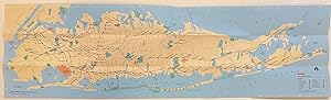
Long Island Rail Road Map
Metropolitan Transit Authority (MTA)
Published by Metropolitan Transit Authority, New York, 1989
Used
From
Argosy Book Store, ABAA, ILAB, New York, NY, U.S.A.
Seller rating 5 out of 5 stars

Heritage Bookseller
AbeBooks member since 1996
This specific copy is no longer available. Here are our closest matches for Long Island Rail Road Map.
About this Item
Description:
Pocket map. Color lithograph. Sheet measures 35 1/4 x 10 1/8", folded measures 8 3/4" x 3 1/2" This LIRR map issued in 1989 features a colorful map of New York City and Long Island. Railroad branches and stations are prominently labeled, and major roads and highways are also shown. Airports and parks are distinctively colored. Verso includes index of LIRR stations and travel connections; subway connections with three inset maps showing subway lines around Penn Station, Jamaica Station, Flushing, Woodside, and Hunters Point connections, and Flatbush Avenue Terminal; and places of interest with their respective locations and phone numbers. Seller Inventory # 308619
Bibliographic Details
Title: Long Island Rail Road Map
Publisher: Metropolitan Transit Authority, New York
Publication Date: 1989