
Johnson's Florida
JOHNSON, A.J.
Published by A.J. Johnson, New York, 1867
Used
unbound
From
Argosy Book Store, ABAA, ILAB, New York, NY, U.S.A.
Seller rating 5 out of 5 stars
![]()
Heritage Bookseller
AbeBooks member since 1996
About this Item
Description:
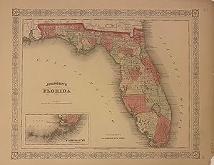
Map. Engraving with original hand coloring. New York: A.J. Johnson, 1867. Image measures 12 1/4" x 15 1/4" Beautiful large-scale map of Florida with counties distinguished by different colors. Includes detailed inset of the Florida Keys. Chip to margins, not affecting the image. Alvin Jewett Johnson (1827-1884) is one of the most prolific American publishers of the 19th century. He opened his own company in 1856 that produced atlases, maps and encyclopedias. The company made great maps based on those by J.H. Colton and Johnson produced a newly updated version every year up until the late 19th century. Seller Inventory # 315895
Bibliographic Details
Title: Johnson's Florida
Publisher: A.J. Johnson, New York
Publication Date: 1867
Binding: unbound
Top Search Results from the AbeBooks Marketplace

Johnson's Map of Florida
Published by
A.J. Johnson, New York, 1867
Used
Seller: Nicholas D. Riccio Rare Books, ABAA, Florham Park, NJ, U.S.A.
Seller rating 4 out of 5 stars
![]()
Unbound, colored engraved map, decorative boarder, 16" x13". Some toning, browing, and aging; otherwise fairly bright and clean and in very good condition. Alvin Jewett Johnson (1827-1884) appears to have entered the map publishing business in 1860. It appears that he obtained J.H. Colton's map copyrights, and published the first installment of the Johnson's New Illustrated (Steel Plate) Family Atlas In that year. Many of the maps Johnson would use would bear the J.H. Colton copyright for many years. Johnson's Atlas would run from 1860 to 1885. While Johnson would use somewhat similar boarder designs, map coloring would sometimes appear a little heavier than the earlier Colton maps. This map of Florida is from the 1867 edition of Johnson's Illustrated Family Atlas, and has good coloring and substantial detail. Like the Colton map of Florida, this map includes a small inset map of the Florida Keys. Ristow 325-326. Seller Inventory # 101207
Quantity: 1 available

Seller Image
Johnsons Florida'
Used
Seller: Art Source International Inc., Boulder, CO, U.S.A.
Seller rating 3 out of 5 stars
![]()
This antique map came from Johnson's New Illustrated (Steel Plate) Family Atlas, published in 1867, by A.J. Johnson. These maps are some of the most colorful and accurate maps produced in the 1860's, their attention to detail and the fine steel engraving make them works of art. Johnson maps are characterized by hand coloring in red, green, yellow, and pink and distinctive borders, including iron scrollwork and a Celtic design. This beautiful map of the States of Florida shows counties, cities and towns, lakes, rivers, and water bodies, railroads, forts, and wagon trails. A fine piece that would make a nice addition to any wall in a home or office. Includes an inset map of The Florida Keys. This map measures 15 inches by 12 inches. Seller Inventory # 62990
Quantity: 1 available
Seller Image
Johnsons Florida'
Used
Seller: Art Source International Inc., Boulder, CO, U.S.A.
Seller rating 3 out of 5 stars
![]()
Near the forefront of the atlas publication industry for a quarter century was mapmaker and aggressive marketer Alvin Jewitt Johnson. Around 1860, in a transaction that remains somewhat mysterious, Johnson acquired a set of detailed plates from J.H. Colton, one of the foremost mapmakers of the century, and used them to print the Johnson atlas that was to find its way into homes across the country. Johnsons New Illustrated Family Atlas was first published in 1860, and today these maps have become prized collectibles and true works of cartographic art. The attention to detail and fine hand coloring of these maps make them some of the best collectibles maps from the 19th century. This map shows Florida, with an inset of the Florida keys. Cities, towns, roads, lakes, rivers and counties are shown. This map measures 18 inches by 14 inches. Seller Inventory # 36642
Quantity: 1 available
Seller Image
Johnsons Florida'
Used
Seller: Art Source International Inc., Boulder, CO, U.S.A.
Seller rating 3 out of 5 stars
![]()
This map is from Johnsons New Illustrated Family Atlas of the World printed in 1868 by A.J. Johnson. Johnson maps are characterized by hand coloring in red and green and distinctive borders, including iron scroll work and a Celtic design. This beautiful map of Florida is colored in vibrant pastels and has details including the names of counties and important cities, rail lines, lakes and rivers.The Everglades are identified as is the land occupied at that time by the Seminole Indians in Southern Florida. An inset is included that shows the Keys at the same scale as the main map and indicates the Indian hunting ground. This map measures 15 inches by 11.75 inches. Seller Inventory # 63171
Quantity: 1 available
Johnson's Florida by Johnson & Browning.
Published by
Johnson and Browning, New York ., 1860
Used
Seller: Angelika C. J. Friebe Ltd. - MapWoman, Dorking, United Kingdom
Seller rating 5 out of 5 stars
![]()
No Binding. Condition: Good. lithographed map with original colouring; image 31 x 39 cm. paper edges slightly browned; top margin cut into decorative border which has been repaired (see photo); o/w very good cond.- A very decorative and detailed map of Florida with an inset of the Florida Keys, from Johnson's 'New Illustrated Family Atlas, With Descriptions, Geographical, Statistical, And Historical. Compiled, Drawn, and Engraved Under The Supervision of J. H. Colton And A. J. Johnson'. Seller Inventory # 3918
Quantity: 1 available