

A Hand Book of Map Drawing Adapted Especially to the Maps in Mitchell's New Series of School Geographies
Keam, Peter; Mickleborough, John
Published by E. H . Butler & Co, Philadelphia, 1869
Used
Hardcover
From
Antipodean Books, Maps & Prints, ABAA, Garrison, NY, U.S.A.
Seller rating 4 out of 5 stars
![]()
Heritage Bookseller
AbeBooks member since 1996
This specific copy is no longer available. Here are our closest matches for A Hand Book of Map Drawing Adapted Especially to the Maps in Mitchell's New Series of School Geographies by Keam, Peter; Mickleborough, John.
About this Item
Description:
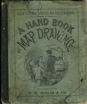
Instructional book of maps, steel engravings by J. M. Atwood of Philadelphia, with original color. With geometric shapes on the left hand page and map with the geometric shapes superimposed on the right hand page. A learning aid for map drawing, using geometric figures such as squares and triangles to teach students the rough outline of an area. With the map of the United States showing present day Oklahoma as "Indian Territory" and with the Baja Peninsula labeled "Lower California". With 25 color engraved maps, most of the United States, but also including a Western and an Eastern Hemisphere, and maps of Europe, Asia and Africa. Sml square 8vo, 57pp, engraved color maps throughout. Quarter dark green cloth with illustrated stiff paper boards. Illustration at front cover showing a teacher using a map with geometric figures overlaid to instruct students of geography. Covers rubbed and marked with damp; inside rear board quite rippled with damp. Owner name inside front cover, front free end paper lacking, very top edge of pages marked by damp. Seller Inventory # 17340
Bibliographic Details
Title: A Hand Book of Map Drawing Adapted ...
Publisher: E. H . Butler & Co, Philadelphia
Publication Date: 1869
Binding: Hardcover
Condition: Good +
Top Search Results from the AbeBooks Marketplace

A Hand-Book of Map Drawing, Adapted Especially to the Maps in Mitchell's New Series of School Geographies
Published by
Philadelphia, Philadelphia, 1869
Used
Hardcover
Seller: High Ridge Books, Inc. - ABAA, South Deerfield, MA, U.S.A.
Seller rating 5 out of 5 stars
![]()
1/4 leather with printed boards, moderately worn. 57 pp., fine condition internally. Most of the contents consist of double-page spreads with a map of several of the United States on the right side and a framework for drawing that particular map on the left. Seller Inventory # b01076
A Hand-Book of Map Drawing Adapted Especially to the Maps in Mitchell's New Series of School Geographies
Published by
E. H. Butler & Co, Philadelphia, 1869
Used
Hardcover
Seller: McBlain Books, ABAA, Hamden, CT, U.S.A.
Seller rating 4 out of 5 stars
![]()
Hardcover. Condition: Good. maps, 57p. Original cloth back green boards. 20cm. Cover slightly bowed. Some dampstaining on front cover and adjacent endpaper. Ends of backstrip chipped. Contents sound and clean. Seller Inventory # 90619