

An Entire New Plan of the Cities of London & Westminster with the Borough of Southwark: Comprehending the New Buildings and other Alterations
MOGG, Edward
Published by Edward Mogg, London, 1820
Used
unbound
From
Argosy Book Store, ABAA, ILAB, New York, NY, U.S.A.
Seller rating 5 out of 5 stars
![]()
Heritage Bookseller
AbeBooks member since 1996
This specific copy is no longer available. Here are our closest matches for An Entire New Plan of the Cities of London & Westminster with the Borough of Southwark: Comprehending the New Buildings and other Alterations by MOGG, Edward.
About this Item
Description:
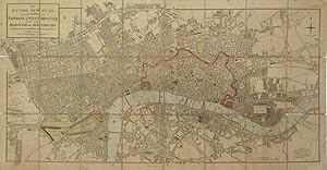
Map. Pocket map with linen backing. Engraving with hand-coloring. Image measures 17.75" x 35.25". Comes with original slipcase. London: 1820 This early pocket map of London shows the city laid out in 1820 around the Thames River, which snakes along the lower half of the map. The city and its surrounding boroughs extend out from the river's shores, with fine engraving of streets and buildings offering detailed insight into the city's development in the early 19th century. Exceptionally detailed, it notes individual streets, parks, important buildings, bridges and docks from Hyde Park east as far as Grand Surrey Outer Dock. Map is in good condition with some wear and splits on linen backing. Overall toning and some stains at places. Edward Mogg was a London publisher, engraver and map seller in the first half of the 19th century. His maps and travel guides to London were famous. He also specialized in road maps road maps of England and Wales. This map is a fine example of his London maps. Seller Inventory # 262721
Bibliographic Details
Title: An Entire New Plan of the Cities of London &...
Publisher: Edward Mogg, London
Publication Date: 1820
Binding: unbound
Top Search Results from the AbeBooks Marketplace

An Entire New Plan of the Cities of London & Westminster: With the Borough of Southwark: Comprehending the New Buildings and other Alterations to the Year 1809.
Published by
London: Edward Mogg, January 1st, . 5th edition., 1809
Used
Seller: Lighthouse Books, ABAA, Dade City, FL, U.S.A.
Seller rating 3 out of 5 stars
![]()
18.5 x 34 ins., copper engraving, handcolored, dissected and mounted on linen. A detailed map extending north to Pentonville, eastwards to Stepney Green, south to Lambeth Palace, and west to Knightsbridge and Paddington. Very Good, folding into original rubbed and worn slip case, with Mogg's label on front and a list of "Hackney Coach Fares" on reverse. British History, European History, Maps, London, Westminster. yxxsl. Seller Inventory # 7431fd
Quantity: 1 available

Seller Image
An Entire New Plan of the cities of London and Westminster: with the Borough of Southwark: Comprehending the New Buildings and other Alterations, to the year 1812.
Published by
London. c1812, 1812
Used
Seller: Peter Harrington. ABA/ ILAB., London, United Kingdom
Seller rating 5 out of 5 stars
![]()
A detailed and interesting plan of London, dissected into 24 separate pieces, linen backed, with a mixture of block and outline colour. The colour is mainly confined to the river, gardens, fields, public parks and squares. Map folds down into its original dark blue slipcase with orange and black title. Slight wear to slipcase. Plan covers from Hyde Park to Whitechapel, from Islington to Bermondsey. Howgego No 227 (4) Size: 475 x 890 mm. Copperplate engraving with some original colour. Good condition. Slight staining. Unframed. Seller Inventory # 68064
Quantity: 1 available