About this Item
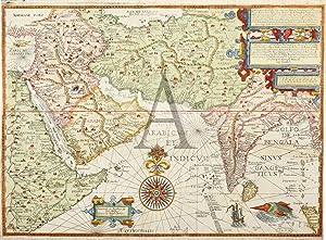
The very rare English edition (1598) of Linschoten's ground breaking map which revealed for the first time the sea route to the Spice Islands, via the African west coast, then to Goa and onto Malacca, from the most important and detailed c.16th travel account of the Orient. Linschoten's, Itinerario, account revealed for the first time, the sea routes and also provided the crucial navigational information (rutters) to all the important Spice Islands. The map extends from Africa to the East Indies and includes the Portuguese controlled centres of the lucrative spice trade. When issued, this map was the most up-to-date and detailed navigational chart of the Indian Ocean and Arabian sea. It provided for the first time Portuguese information obtained by Linschoten during his employment by the Archbishop of Goa and which was later revealed in his published accounts. In the early 16th century, the Netherlands were united with Spain under the Holy Roman Emperor Charles V (Dom Carlos I, Emperor of Spain). Seeking religious freedom and independence from tyrannical rule, the Netherlands fought an extended war against Spain, finally declaring independence with the establishment of the Seven United Provinces in 1579. The creation of a united and independent Dutch state had a profound effect on the course of European power struggles. In 1580, Charles's successor, Phillip II, invaded Portugal and in order to appease the Portuguese gentry after the conquest, gave exclusive shipping rights over European coastal trade to the Portuguese. This effectively barred Dutch merchants from trading in goods from the East and forced them to search for an alternative source of supply. In June 1594, Linschoten returned to the Netherlands and immediately set sail on the Mercury, under the command of William Barentz, in search of a north-east passage to the Orient. The following year, with the assistance of the Amsterdam publisher Cornelis Claesz, Linschoten wrote Reysgeschrift van der Navigatien der Portugaloysers in Orienten (Travel Accounts of Portuguese Navigation in the Orient) from observations collected on his travels. This work contained a large number of sailing directions, not only of shipping routes between Portugal and the East Indies but also between India, China and Japan. This information unlocked the secrets of the Portuguese spice trade at a pivotal time for Dutch merchants. Linschoten followed this work a year later with his Itinerario (1596), which not only incorporated his previous work but expanded the account to incorporate information on the Americas. In 1598 it was pirated in an English translation by the London publisher John Wolfe with the title John Huighen van Linschoten, His discours of voyages into ye Easte and West Indies: deuided into foure bookes. In these accounts, Linschoten suggested approaching the Indies via the western side of Sumatra and the Sunda Strait in order to avoid the Portuguese controlled straits of Malacca. His Itinerario contained so much detailed and accurate information about shipping lanes, winds, and currents, that seafarers could virtually use it as a handbook. Many of his maps were in fact copies of charts by the Portuguese cartographer Ferno Vaz Dourado. Linschoten's work was 'held in such high esteem that for nearly a century, a copy was given to each ship proceeding to India for use as a guide to the sailing directions' (Wardington). The regular use of Linschoten's account by pilots and captains aboard merchant ships has made existing copies of his work extremely rare. From John Huighen van Linschoten his Discours of Voyages unto ye Easte & West Indies. Devided into Foure Bookes. Paper size: 525mm x 400 mm (20.6" x 15.7"). Condition: Repaired tear to left margin as often found, otherwise in good condition. Two sheets joined. Technique: Hand coloured copper engraving. Seller Inventory # LIVOS 003
Contact seller
Report this item
![]()
