
Order Total (1 Item Items):
Shipping Destination:

Road Map by Geographia (52 results)
Skip to main search results
Product Type
- All Product Types
- Books (37)
- Magazines & Periodicals
- Comics
- Sheet Music
- Art, Prints & Posters
- Photographs
- Maps (15)
-
Manuscripts &
Paper Collectibles
Condition
- All Conditions
- New
- Used
Binding
Collectible Attributes
- First Edition (5)
- Signed
- Dust Jacket (1)
- Seller-Supplied Images (33)
- Not Printed On Demand
Free Shipping
Seller Location
Seller Rating
-
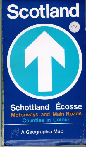
Scotland Map: Main Road and Political Map
Published by Geographia, 1989
ISBN 10: 0092023908ISBN 13: 9780092023903
Book
Condition: Good. Most items will be dispatched the same or the next working day. A tan to the page edges/pages . Minor shelf wear.
-
Condition: Fair. No Edition Remarks. Unpaginated. Colour folded map in pictorial paper cover. Moderate tanning and creasing to surfaces with marking overall. Paper cover has moderate edge wear with light rubbing and creasing. Large tears and chipping, with heavy tanning and marking overall. Book is slightly curled.
-
Condition: Good. No edition remarks. Unpaginated. Colour paper map on canvas between paper covers. Panels are in good condition with mild tanning and thumb-marking present. Minor tears and stains to edges. Notable smudges and stains to reverse. Paper cover has mild edge wear with mild corner curling. Notable scratching and marking to covers. Mild loss to label.
-

North Devon: "Geographia" Large Scale Road Map. 2 miles: 1 inch.
Published by Geographia, London, 1965
First Edition
Paperback. Condition: Good. First Edition. undated orange wrappers. Book.
-
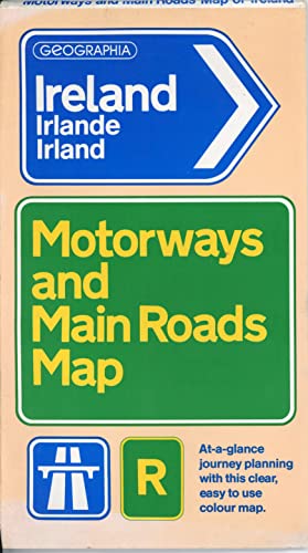
Ireland Map: Main Road and Political Map: 9M-1"
Published by Paperback, 1989
ISBN 10: 0092023800ISBN 13: 9780092023804
Book
Condition: Good. Paperback Good Offered by the charity Langdon (supporting men & women with disabilities) - Dispatched within 1 working day.
-
Condition: Good. 2 milles :1 inch. Ex-library and may have the usual library markings inside.In good all round condition. Publication date absent (mid-20th century). Please note the Image in this listing is a stock photo and may not match the covers of the actual item,100grams, ISBN:
-
Condition: Bueno. Published by Geographia. London. Showing 1st, 2nd and other roads selection of footpaths, places of interest, etc. 20 x 12 (plegado). Mapa. Map.
-
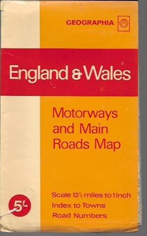
England & Wales: Motorways and Main Roads Map, Scale 12 1/2 Inches to 1 Inch (c. 1970)
Published by Geographia, 1970
Book
Paperback. Condition: VG. Vintage road map in orange, red and beige coated card covers. No date to map but dates from between 1966-1971 (based on M4 construction). Folded 5 1/8" x 81/2". Map is NF with only occasional stress creases; clean and bright. Folder is VG- with covers soiled along edges with 1" tear toward one corner. Central panels brightly colored with light overall rubbing and soil.
-
New Map of England & Wales showing main roads with Ministry of Transport Numbers.
Published by London: "Geographia" Ltd, n.d.
Seller: OLD WORKING BOOKS & Bindery (Est. 1994), West Brookfield, MA, U.S.A.
Association Member: SNEAB
Seller Rating:

Paper fold-out map in printed folder with yapped edges . 100 x 75cm. VG/Unclipped price in mylar. One 9.5cm tear to top at 4 degree longitude mark.
-
Geographia" Large Scale ROAD MAP of LAKE DISTRICT on Cloth
Published by Geographia Ltd, Fleet Street, London EC4
Book
Soft cover. Condition: Good. No Jacket. Good condition soft cover map on cloth. No date found. Original price 2/6 No foxing, good clean detail. Large Scale. No foxing, no previous owners marks.
-
Geographia" Large scale Road Map Paignton [scale 2 Inches to 1 Mile approx]
Published by Geographia, London, 1950
Paperback. Condition: Good. New and Up-To-date. 16mo Folded Sheet. undated. States Paignton and district on cover but extends from Exeter to Liskeard. One segment tear. Some dap effect to cover. Book.
-
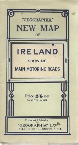
Geographia New Map of Ireland showing Main Motoring Roads.
Published by London: Geographia, c1930., 1930
Seller: Saintfield Antiques & Fine Books, Northern Ireland, United Kingdom
Seller Rating:

Map
Soft cover. Condition: Very Good. Scale 10 miles to 1 inch, card covers, dissected linen-backed map. Our estimated date of publication is based on a railway closed in 1933 but still shown as open. The map itself is in very good, clean condition, but the card cover into which it folds is showing some wear.
-
Large 'pull out' Map in salmon coloured card covers in Very Good condition. Covers sunned. Three Miles to the Inch.
-
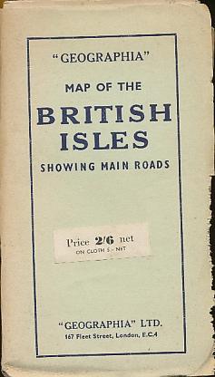
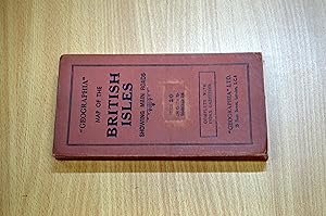
Geographia" Map of the British Isles Showing Main Roads
Published by "Geographia" LTD., London, 1940
Paperback. Condition: Very Good+. Covers have some edgewear. ; Colored map is in excellent condition. With no known tears or chips to the map. No date given. ; Color Map;
-

Northern Ireland Motorways and Main Roads Map
Published by Geographia Map Company, 1989
ISBN 10: 0092025005ISBN 13: 9780092025006
Book
Paperback. Condition: Acceptable. One or two marks to an otherwise clean and neatly folded map. The cover has numerous creases byt is not torn. Please ask for photo(s) if there isn't an image of our copy. COVID/BREXIT/ROYAL MAIL STRIKES MAY MEAN DELAYS IN TRANSIT. Priority orders will be dispatched by Royal Mail TRACKED 24 or courier (particularly if over 2kg). Standard mail will be dispatched by Royal Mail TRACKED 48 (up to 2kg), heavier items by courier . Overseas orders will be dispatched by Royal Mail International.Tracked. PLEASE CONTACT ME FOR MY PRIVACY POLICY.
-
Soft cover. Condition: Very Good. 1st Edition. vg fold out copy with pink cover.neat name on cover. no date but publishers price is 6d. on front. states entirely new map right up to date.
-
![Seller image for 2 Miles to 1 Inch Geographia Large Scale Road Map of Luton and St. Albans [Code M BM] for sale by Little Stour Books PBFA Member](https://pictures.abebooks.com/inventory/md/md2973241803.jpg)
2 Miles to 1 Inch Geographia Large Scale Road Map of Luton and St. Albans [Code M BM]
Published by Published by Geographia Ltd., 167 Fleet Street, London March [Code M BM] 1943., 1943
Seller: Little Stour Books PBFA Member, Canterbury, United Kingdom
Association Member: PBFA
Seller Rating:
Green card covers with navy lettering to the front. Paper folded 21 section map. 4 miles to 1 inch. Small tape repairs to some corners of the reverse of the map, in Very Good clean condition, priced 1/3 to the front cover. Member of the P.B.F.A. BEDFORDSHIRE.
-
![Seller image for Geographia Large Scale Road Map of England and Wales Showing Main Roads with Ministry of Transport Numbers [M BM] for sale by Little Stour Books PBFA Member](https://pictures.abebooks.com/inventory/md/md3956301799.jpg)
Geographia Large Scale Road Map of England and Wales Showing Main Roads with Ministry of Transport Numbers [M BM]
Published by Published by Geographia Ltd., 167 Fleet Street, London February [Code U BE] 1945., 1945
Seller: Little Stour Books PBFA Member, Canterbury, United Kingdom
Association Member: PBFA
Seller Rating:
Blue card covers with navy lettering to the front. Cloth backed 35 section colour paper map. In Very Good clean condition, priced 5/6 to the front cover. Member of the P.B.F.A. CARTOGRAPHY, MAPS, PLANS.
-
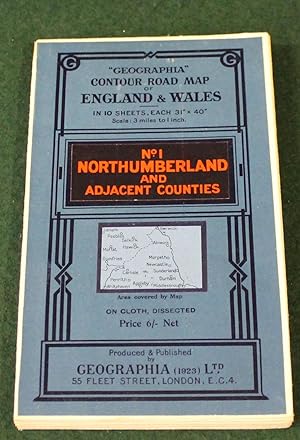
Geographia" 10 Sheet Contour Road Map of England. Sheet 1 Northumberland and Adjacent Counties. Scale 3 miles to 1 inch.
Published by London: Geographia Ltd. circa, 1920
Coloured folding map dissected and mounted on linen, 31 x 40 inches, folding within the printed card covers; very good indeed.
-
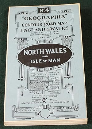
Geographia" 10 Sheet Contour Road Map of England. Sheet 4, North Wales and Isle of Man. Scale 3 miles to 1 inch.
Published by London: Geographia Ltd. circa, 1920
Coloured folding map dissected and mounted on linen, 31 x 40 inches, folding within the printed card covers; very good indeed.
-
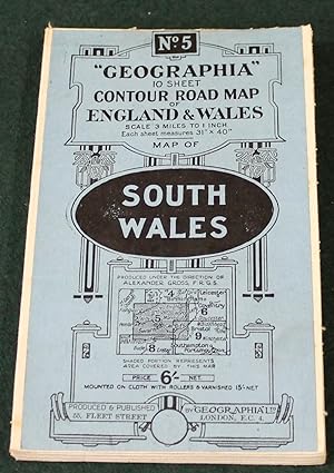
Geographia" 10 Sheet Contour Road Map of England. Sheet 5, South Wales. Scale 3 miles to 1 inch.
Published by London: Geographia Ltd. circa, 1920
Coloured folding map dissected and mounted on linen, 31 x 40 inches, folding within the printed card covers; very good indeed.
-
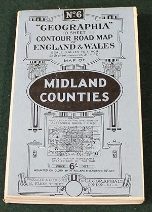
Geographia" 10 Sheet Contour Road Map of England. Sheet 6, Midland Counties. Scale 3 miles to 1 inch.
Published by London: Geographia Ltd. circa, 1920
Coloured folding map dissected and mounted on linen, 31 x 40 inches, folding within the printed card covers; very good indeed.
-
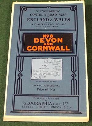
Geographia" 10 Sheet Contour Road Map of England. Sheet 8, Devon & Cornwall. Scale 3 miles to 1 inch.
Published by London: Geographia Ltd. circa, 1920
Coloured folding map dissected and mounted on linen, 31 x 40 inches, folding within the printed card covers; very good indeed.
-
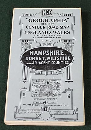
Geographia" 10 Sheet Contour Road Map of England. Sheet 9, Hampshire, Dorset, Wiltshire and Adjacent Counties. Scale 3 miles to 1 inch.
Published by London: Geographia Ltd. circa, 1920
Coloured folding map dissected and mounted on linen, 31 x 40 inches, folding within the printed card covers; very good indeed.
-
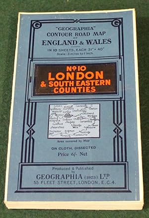
Geographia" 10 Sheet Contour Road Map of England. Sheet 10: London & South Eastern Counties. Scale 3 miles to 1 inch.
Published by London: Geographia Ltd. circa, 1920
Coloured folding map dissected and mounted on linen, 31 x 40 inches, folding within the printed card covers; very good indeed.
-
[Prenton, Higher Bebington, Stareton, Woodchurch Road, Stanley Wood] (Map Section #172)
Publication Date: 1935
Map
Condition: Good. BIRKENHEAD Tranmere Prenton Higher Bebington Stareton Woodchurch Road 1935 map. Vintage colour map ; Geographers A-Z Map Co / Geographia / Pearsall, Phyllis & Gross, Alexander (1935). 33.5 x 24.5cm, 13 x 9.5 inches. Condition: Good. The item offered for sale is one page of a map originally published on two adjacent pages - it lacks a full border and may have a tight margin along one edge (see image). There are images and/or text printed on the reverse side of the picture. In some cases this may be visible on the picture itself or around the margin of the picture.
-
Geographia Large Scale Road Map of: Gloucestershire.
Published by Geographia Ltd., London, UK.
Seller: J J Basset Books, bassettbooks, bookfarm.co.uk, Peter Tavy, United Kingdom
Seller Rating:
Map
Blue Decorated Cloth. Condition: Very Good (AVERAGE). No Jacket. Map Mounted on Cloth. (illustrator). The rear side of map has some foxing and brown stain marks.This book will be POSTED AT OUR STANDARD RATES FULLY INSURED (UK) ONLY . Please email for further details. OFFERED FOR SALE BY A FULL-TIME STOCKHOLDING CAREER BOOKSELLER WHO TELLS YOU WHO THEY ARE AND WHAT THEIR TELEPHONE AND ADDRESS CONTACT DETAILS ARE! POSTED AT OUR STANDARD RATES FULLY INSURED! (UK ONLY). FEEL FREE TO E-MAIL FOR PHOTOGRAPHS AND FURTHER DETAILS. Size: 12mo - over 6�" - 7�". Not Signed or Inscribed. Fold Out Map.
-
Hardcover. Condition: Very Good. Very Good. Hardcover bound in maroon buckram boards. Fold-out map of the British Isles in colour. Text bright. Binding tight. Minor age wear. ALL ITEMS ARE DISPATCHED FROM THE UK WITHIN 48 HOURS ( BOOKS ORDERED OVER THE WEEKEND DISPATCHED ON MONDAY) ALL OVERSEAS ORDERS SENT BY TRACKABLE AIR MAIL. IF YOU ARE LOCATED OUTSIDE THE UK PLEASE ASK US FOR A POSTAGE QUOTE FOR MULTI VOLUME SETS BEFORE ORDERING.
-
Geographia New Map of England & Wales Showing Main Roads with M o f T. Numbers
Published by Geographia, UK
Book
Paperback. Condition: Good. worn on some folds.
-

Map. Condition: Good. Folded paper map in very good condition, pencil notes in English Channel, some foxing; card cover tanned & edgeworn. 2 miles to 1 inch. Undated, but 1930s?.

![Seller image for [Prenton, Higher Bebington, Stareton, Woodchurch Road, Stanley Wood] (Map Section #172) for sale by Antiqua Print Gallery](https://pictures.abebooks.com/inventory/md/md31104985743.jpg)