Order Total (1 Item Items):
Shipping Destination:

Official Historical Atlas Map (30 results)
Skip to main search results
Product Type
- All Product Types
- Books (30)
- Magazines & Periodicals
- Comics
- Sheet Music
- Art, Prints & Posters
- Photographs
- Maps
-
Manuscripts &
Paper Collectibles
Condition
Binding
Collectible Attributes
- First Edition
- Signed
- Dust Jacket
- Seller-Supplied Images (7)
- Not Printed On Demand (28)
Free Shipping
Seller Location
Seller Rating
-
![Stock image for The illustrated atlas and history of Yolo County, Cal.containing a history of California from 1513 to 1850, a history of Yolo County from 1825 to 1880, with statistics portraits of well-known citizens and the official county map [HARDCOVER] for sale by Books Puddle](https://pictures.abebooks.com/isbn/9789333101998-uk-300.jpg)
The illustrated atlas and history of Yolo County, Cal.containing a history of California from 1513 to 1850, a history of Yolo County from 1825 to 1880, with statistics portraits of well-known citizens and the official county map [HARDCOVER]
Published by Isha Books, 2013
ISBN 10: 9333101993ISBN 13: 9789333101998
Book
Condition: New. pp. 277.
More buying choices from other sellers on AbeBooks
New offers from � 24.17
-
Soft cover. Condition: Fine. Large format yellow stiff printed paper covers clean tight and unmarked; The Hermon Dunlap Smith Center for the History of Cartography, Occasional Publication No. 1. 68 pages.
More buying choices from other sellers on AbeBooks
Used offers from � 24.60
-
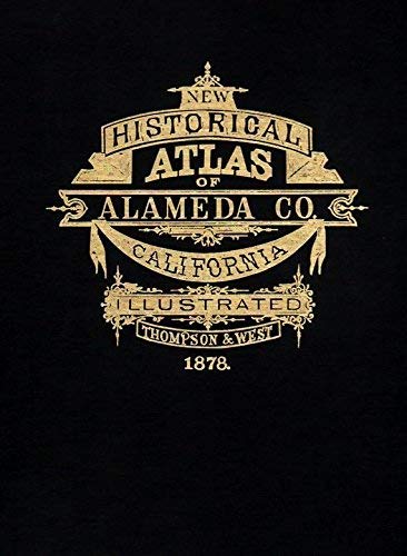
Official and Historical Atlas Map of Alameda County, 1878
Published by Valley Publishers, 1976
ISBN 10: 0913548340ISBN 13: 9780913548349
Book
hardcover. Condition: Good.
More buying choices from other sellers on AbeBooks
New offers from � 206.20
Used offers from � 28.46
Also find Hardcover
-
![Seller image for The illustrated atlas and history of Yolo County, Cal., containing a history of California from 1513 to 1850, a history of Yolo County from 1825 to 1880, with statistics . portraits of well-known citizens, and the official county map (1879) [LeatherBound] for sale by True World of Books](https://pictures.abebooks.com/inventory/md/md31618708271.jpg)
LeatherBound. Condition: New. LeatherBound edition. Condition: New. Reprinted from 1879 edition. Leather Binding on Spine and Corners with Golden leaf printing on spine. Bound in genuine leather with Satin ribbon page markers and Spine with raised gilt bands. A perfect gift for your loved ones. NO changes have been made to the original text. This is NOT a retyped or an ocr'd reprint. Illustrations, Index, if any, are included in black and white. Each page is checked manually before printing. As this print on demand book is reprinted from a very old book, there could be some missing or flawed pages, but we always try to make the book as complete as possible. Fold-outs, if any, are not part of the book. If the original book was published in multiple volumes then this reprint is of only one volume, not the whole set. Sewing binding for longer life, where the book block is actually sewn (smythe sewn/section sewn) with thread before binding which results in a more durable type of binding. Pages: 288.
-
![Seller image for The people's war book and pictorial atlas of the world. Containing official war reports and authentic articles by Marshal Foch [and others] Also a complete Pictorial atlas of the world describing every nation in the world and giving new colored maps of every country on the globe, together with a valuable collection of photographs showing important historical views and picturing the natural wonders of the world (1920) [LeatherBound] for sale by True World of Books](https://pictures.abebooks.com/inventory/md/md31657509153.jpg)
The people's war book and pictorial atlas of the world. Containing official war reports and authentic articles by Marshal Foch [and others] Also a complete Pictorial atlas of the world describing every nation in the world and giving new colored maps of every country on the globe, together with a valuable collection of photographs showing important historical views and picturing the natural wonders of the world (1920) [LeatherBound]
Publication Date: 2023
Book Print on Demand
LeatherBound. Condition: New. LeatherBound edition. Condition: New. Reprinted from 1920 edition. Leather Binding on Spine and Corners with Golden leaf printing on spine. Bound in genuine leather with Satin ribbon page markers and Spine with raised gilt bands. A perfect gift for your loved ones. NO changes have been made to the original text. This is NOT a retyped or an ocr'd reprint. Illustrations, Index, if any, are included in black and white. Each page is checked manually before printing. As this print on demand book is reprinted from a very old book, there could be some missing or flawed pages, but we always try to make the book as complete as possible. Fold-outs, if any, are not part of the book. If the original book was published in multiple volumes then this reprint is of only one volume, not the whole set. Sewing binding for longer life, where the book block is actually sewn (smythe sewn/section sewn) with thread before binding which results in a more durable type of binding. Pages: 922 Foch, Ferdinand, 1851-1929,Miller, J. Martin (James Martin), 1859-1939,James, George Wharton, 1858-1923,Plewman, W. R. (William Rothwell), 1880-.
-

ILIFF`s IMPERIAL ATLAS of the WORLD; Compiled from the latest official sources. Showing the entire Railroad system in detail, Postal Routes, Historical and Geographical description of each State and Territory and of every Country of the World, with Correct, Plain and Beautiful Maps, showing all Railroads Stations, Post Offices, etc., etc., etc. Also a complete Indexed List of Towns and Countries with their Population, according to the 1890 Census. *
Published by JOHN W. ILIFF and COMPANY, * * * * *, 1891
Book
Hardcover. Condition: Fair. 1891 B00K: Fair/ (illustrator). B00K: Fair/ $225.15, Reduced From Tall Wide Thick, H/c. ILIFF'S IMPERIAL ATLAS of the WORLD; Compiled from the latest official sources. Showing the entire Railroad system in detail, Postal Routes, Historical and Geographical description of each State and Territory and of every Country of the World, with Correct, Plain and Beautiful Maps, showing all Railroads Stations, Post Offices, etc., etc., etc. Also a complete Indexed List of Towns and Countries with their Population, according to the 1890 Census. * D/j: None. ILIFF, John W. JOHN W. ILIFF and COMPANY 1891 Spine Cover Gone, Tall And Wide Hard Cover BooK: Fair/Good/, 319 Numbered Pages That Are Mostly Tight To The Spine, Shelf, Edge And Corner Wear. Printed On Tan Paper, Browning From Aging. Pages Are In Delicate Condition, Starting To Come Loose From The Spine. Corners Are Worn Through. Front Cover Is Loose And Included. D/J: None Description Applies To This BooK, ONLY. = This BooK Is Hard To Find, Will Be = Packaged And Shipped Carefully, To Avoid Shipping Damage And Will Make It, An Excellent Addition To Your Own Personal Library Collection, Or As A Gift. World Wide Shipping, Available.
-
Official and Historical Atlas Map of Alameda County, California. Compiled, Drawn and Published From Personal Examinations and Surveys.
Published by Valley Publishers., Fresno., 1976
Gilt decorated hard cover. Bicentennial Reprint. Lithographic reproductions, maps and statistics. Very scarce in this condition. Fine copy. 178 pps.
-

Official and Historical Atlas Map of Alameda County, California. Compiled, Drawn and Published From Personal Examinations and Surveys.
Published by Valley Publishers., Fresno., 1976
Gilt decorated hard cover. Bicentennial Reprint. Lithographic reproductions, maps and statistics. Very scarce in this condition. Fine copy. As new, 178 pps.
-
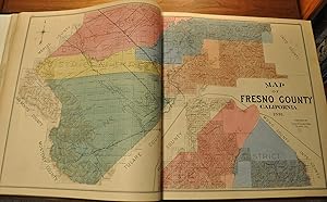
Official Historical Atlas Map of Fresno County - Fabulous late 19th century atlas of Fresno County, fully restored.
Publication Date: 1891
Seller: Curtis Wright Maps, Berwyn, IL, U.S.A.
Seller Rating:

Condition: Very Good. "This spectacular atlas of Fresno County, California was published in Tulare by Thomas H. Thompson in 1891. Its county map was apparently of such fine execution that, according to the title page, the Board of Supervisors declared it "the Official Map of Fresno County." The map is a quality one - bright colors distinguish the various districts while light shading accentuates topographic details. An inset in the lower right includes the northern portion, which is cut off at the top. Here, large areas remain to be subdivided into sections. Towns, post offices, and transportation routes are labeled across the image; providing an interesting overview of the county in the late 19th century. This contemporary detail is emphasized throughout the rest of the atlas, which is arguably of similarly high quality to the county map. A double page map of California highlights how the majority of the state shared the rural composition. It's followed by over 80 single page maps which show a wealth of information on local industry, county organization, topography, and property ownership. The last is particularly emphasized, with names of individuals or businesses labeled across almost every parcel and property in the county. An examination of these names reflects a large immigrant population, and one of the sheets includes an inset map of a local Scandinavian colony. City plans are included for Fresno (3 parts), Selma, and Sanger, in addition to composite sheets covering many smaller towns and villages. Also of interest is the separate sheet of the Yosemite Valley, despite it being located within adjacent Mariposa County. The year prior to publication, a large portion of the valley had been declared a National Park, and its popularity among tourists and residents was likely at a peak. The atlas also contains a number of views and illustrations of local farms (including vineyards) and various properties. One presents a fascinating depiction of an early steam tractor, while others show sprawling ranches, prize livestock, and the county courthouse." Sheet Width (in) 15 Sheet Height (in) 16 Condition Description The entire atlas has been professionally rebound and restored. The original title sheet has been mounted to new quarter leather boards with gilt embossed spine and new endpapers. Contents are generally quite good, though a portion of the margins have been restored or reinforced in several areas on the title page, index sheet, and state map of California. The preface/table of contents has a large tear (repaired) and there's a bit of soiling and faint damp staining in the margins on several sheets. A few have light spotting, and the margins of the patron's directory has a bit of worming. Complete - 122 pages with 18 single page views (3 with fold out panels), 82 single page maps, and 5 double page maps, including a 3 part city plan of Fresno. Remains in very good condition overall.
-
Illustrated Atlas of the County of Lambton bound with Illustrated Atlas of Dominion of Canada containing authentic and complete Maps of all the Provinces the North-West Territories and the Island of NewFoundland from the latest official surveys and plans, by permission of the general and provincial governments, together with a general descriptive history, & c. Also maps of Europe, Asia, Africa, North and South America, United States, Oceanica, The World, & c., & c. and local maps prepared under the direction of D. MacDonald and the Atlas of Victoria County.
Published by H. Belden & Co., Toronto, 1881
Seller: Alexandre Antique Prints, Maps & Books, Toronto, ON, Canada
Seller Rating:

Folio. � morocco with cloth boards, front board with embossed title. , Maps prepared under the direction of D. MacDonald.The maps depict various lot and street plans, Town layouts, period advertising and charming sketches of historical and farm residences., Size : Folio, The list of maps in this atlas: The World in Hemispheres; The Parliament Building Parliament Square Ottawa; Chart of the World on Mercators projection; Europe; Asia; Africa; Oceania; South America; North America; Map of the United States of America; Map of NewFoundland; Chart of the World showing the relative positions Dominion of Canada and the other British possessions; Rail Road map of the Dominion of Canada; New Atlas of the Dominion of Canada counties of Ontario; New Atlas of the Dominion of Canada counties of Ontario; New Atlas of the Dominion of Canada counties of Ontario; New Atlas of the Dominion of Canada districts of Algoma, Parry Sound also parts of Nipissing district and Renfrew Co.; New Atlas of the Dominion of Canada counties of Quebec; New Atlas of the Dominion of Canada counties of Quebec; New Atlas of the Dominion of Canada counties of Quebec also Magdalen Islands; New Atlas of the Dominion of Canada counties of New Brunswick; New Atlas of the Dominion of Canada counties of New Brunswick; New Atlas of the Dominion of Canada counties of Nova Scotia; New Atlas of the Dominion of Canada counties of Nova Scotia, Cape Breton, Prince Edward Island; Map of Manitoba and the North West Territory; Map of British Columbia; Map of part of the North West Territory; Map showing the electoral divisions of the Dominion of Canada sheet no.2; Map showing the electoral divisions of the Dominion of Canada sheet no.1; Geological Map of Canada and NewFoundland sheet no.3; Geological Map of Canada and NewFoundland sheet no.2; Geological map of NewFoundland, Map of Bosanquet Township, Map of the County of Lambton, Map of Warwick Township, Map of Dawn Township, Map of Brooke Township, Map of Plympton Township, Map of Enniskillen Township, Map of Sarnia Township, Map of Sombra Township,Map of Euphemia Township, Map of Moore Township, Map of W. Gwillimbury, Map of Sunnidale Township, Map of N. Orilla Township Map of Vespra Township, Map of Tay Township, Map of S. Orilla Township, Map of Oro Township, Map of Matchedash Township. Covers are worn, spine defective but interior very good.
-
Illustrated Atlas of the County of Victoria bound with Illustrated Atlas of Dominion of Canada containing authentic and complete Maps of all the Provinces the North-West Territories and the Island of NewFoundland from the latest official surveys and plans, by permission of the general and provincial governments, together with a general descriptive history, & c. Also maps of Europe, Asia, Africa, North and South America, United States, Oceanica, The World, & c., & c. and local maps prepared under the direction of D. MacDonald and the Atlas of Victoria County.
Published by H. Belden & Co., Toronto, 1881
Seller: Alexandre Antique Prints, Maps & Books, Toronto, ON, Canada
Seller Rating:
Condition: Worn, interior very good. � morocco with cloth boards, front board with embossed title. , Engraved and lithographed by Rolph, Smith & Co.The list of maps in this atlas: The World in Hemispheres; The Parliament Building Parliament Square Ottawa; Chart of the World on Mercators projection; Europe; Asia; Africa; Oceania; South America; North America; Map of the United States of America; Map of NewFoundland; Chart of the World showing the relative positions Dominion of Canada and the other British possessions; Rail Road map of the Dominion of Canada; New Atlas of the Dominion of Canada counties of Ontario; New Atlas of the Dominion of Canada counties of Ontario; New Atlas of the Dominion of Canada counties of Ontario; New Atlas of the Dominion of Canada districts of Algoma, Parry Sound also parts of Nipissing district and Renfrew Co.; New Atlas of the Dominion of Canada counties of Quebec; New Atlas of the Dominion of Canada counties of Quebec; New Atlas of the Dominion of Canada counties of Quebec also Magdalen Islands; New Atlas of the Dominion of Canada counties of New Brunswick; New Atlas of the Dominion of Canada counties of New Brunswick; New Atlas of the Dominion of Canada counties of Nova Scotia; New Atlas of the Dominion of Canada counties of Nova Scotia, Cape Breton, Prince Edward Island; Map of Manitoba and the North West Territory; Map of British Columbia; Map of part of the North West Territory; Map showing the electoral divisions of the Dominion of Canada sheet no.2; Map showing the electoral divisions of the Dominion of Canada sheet no.1; Geological Map of Canada and NewFoundland sheet no.3; Geological Map of Canada and NewFoundland sheet no.2; Geological map of NewFoundland; Map of Ops Township/ Map of Emily Township; Map of the County of Victoria; Mariposa/ Eldon; Fenelon/ Verulam; Somerville/ Dalton; Bexley/ Digby; Carden/ Longford/ Laxton.Maps prepared under the direction of D. MacDonaldThe maps depict various lot and street plans, Town layouts, period advertising and charming sketches of historical and farm residences., Size : Folio.
-
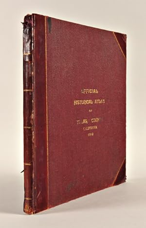
OFFICIAL HISTORICAL ATLAS MAP OF TULARE COUNTY.COMPILED, DRAWN AND PUBLISHED FROM PERSONAL EXAMINATIONS AND SURVEYS.
Published by [Tulare, Ca.?], 1892
Seller: William Reese Company - Americana, New Haven, CT, U.S.A.
Association Member: ABAA ESA ILAB SNEAB
Seller Rating:
4pp. Double-sheet key map plus 108 township maps (many partially colored). Folio. Original three-quarter calf and cloth, front board gilt. Spine extremities rather rough and worn. One free endpaper torn, the other wrinkled. Titlepage a bit dust soiled, else generally clean internally. Overall very good. A detailed subdivision and township atlas of Tulare County, in the southern Central Valley of California. Large lots are labeled with names of the owners, and in this copy many changes of ownership are noted in pencil. Although the preface and contents mention illustrations and portraits, there are none in this copy. A fine, detailed township atlas for a California county. ROCQ 15171. NORRIS CATALOGUE 3965.
-
Illustrated Atlas of the County of Simcoe bound with Illustrated Atlas of Dominion of Canada containing authentic and complete Maps of all the Provinces the North-West Territories and the Island of NewFoundland from the latest official surveys and plans, by permission of the general and provincial governments, together with a general descriptive history, & c. Also maps of Europe, Asia, Africa, North and South America, United States, Oceanica, The World, & c., & c. and local maps prepared under the direction of D. MacDonald and the Atlas of Victoria County.
Published by H. Belden & Co., Toronto, 1881
Seller: Alexandre Antique Prints, Maps & Books, Toronto, ON, Canada
Seller Rating:
Condition: Worn, interior very good. Folio. � morocco with cloth boards, front board with embossed title. , Maps prepared under the direction of D. MacDonald.The maps depict various lot and street plans, Town layouts, period advertising and charming sketches of historical and farm residences.Engraved and lithographed by Rolph, Smith & Co., Size : Folio, The list of maps in this atlas: The World in Hemispheres; The Parliament Building Parliament Square Ottawa; Chart of the World on Mercators projection; Europe; Asia; Africa; Oceania; South America; North America; Map of the United States of America; Map of NewFoundland; Chart of the World showing the relative positions Dominion of Canada and the other British possessions; Rail Road map of the Dominion of Canada; New Atlas of the Dominion of Canada counties of Ontario; New Atlas of the Dominion of Canada counties of Ontario; New Atlas of the Dominion of Canada counties of Ontario; New Atlas of the Dominion of Canada districts of Algoma, Parry Sound also parts of Nipissing district and Renfrew Co.; New Atlas of the Dominion of Canada counties of Quebec; New Atlas of the Dominion of Canada counties of Quebec; New Atlas of the Dominion of Canada counties of Quebec also Magdalen Islands; New Atlas of the Dominion of Canada counties of New Brunswick; New Atlas of the Dominion of Canada counties of New Brunswick; New Atlas of the Dominion of Canada counties of Nova Scotia; New Atlas of the Dominion of Canada counties of Nova Scotia, Cape Breton, Prince Edward Island; Map of Manitoba and the North West Territory; Map of British Columbia; Map of part of the North West Territory; Map showing the electoral divisions of the Dominion of Canada sheet no.2; Map showing the electoral divisions of the Dominion of Canada sheet no.1; Geological Map of Canada and NewFoundland sheet no.3; Geological Map of Canada and NewFoundland sheet no.2; Geological map of NewFoundland; Map of the Mono Township, Map of Mulmur Township, Map of the County of Simcoe, Map of the Essa Township, Map of Tecumseth Township, Map of Flos Township, Map of Medonte Township, Map of Nottawasaga Township, Map of Innisfil Township, Map of Tosoronto Township, Map of Tiny Township, Map of Adjala Township, Map of W. Gwillimbury, Map of Sunnidale Township, Map of N. Orilla Township Map of Vespra Township, Map of Tay Township, Map of S. Orilla Township, Map of Oro Township, Map of Matchedash Township.