
Order Total (1 Item Items):
Shipping Destination:

Maidstone Weald Kent by Ordnance Survey (15 results)
Feedback
Skip to main search results
Search filters
Product Type
- All Product Types
- Books (13)
- Magazines & Periodicals (No further results match this refinement)
- Comics (No further results match this refinement)
- Sheet Music (No further results match this refinement)
- Art, Prints & Posters (No further results match this refinement)
- Photographs (No further results match this refinement)
- Maps (2)
- Manuscripts & Paper Collectibles (No further results match this refinement)
Condition
- All Conditions
- New (No further results match this refinement)
- Used (15)
Binding
- All Bindings
- Hardcover (No further results match this refinement)
- Softcover (7)
Collectible Attributes
- First Edition (No further results match this refinement)
- Signed (No further results match this refinement)
- Dust Jacket (No further results match this refinement)
- Seller-Supplied Images (6)
- Not Print on Demand (15)
Free Shipping
Seller Rating
-

Paperback. Condition: Good. The book has been read but remains in clean condition. All pages are intact and the cover is intact. Some minor wear to the spine.
-

Maidstone and the Weald of Kent (Sheet 188) (OS Landranger Map)
Published by Ordnance Survey
ISBN 10: 0319221881 ISBN 13: 9780319221884
Condition: Good. Most items will be dispatched the same or the next working day.
-

Maidstone and the Weald of Kent (Sheet 188) (OS Landranger Map)
Published by Ordnance Survey
ISBN 10: 0319221881 ISBN 13: 9780319221884
Condition: VeryGood. Most items will be dispatched the same or the next working day.
-
Landranger Maps: Maidstone and the Weald of Kent Sheet 188 (OS Landranger Map)
Published by Ordnance Survey, 1992
ISBN 10: 0319221881 ISBN 13: 9780319221884
Map. Condition: Used; Good. Dispatched, from the UK, within 48 hours of ordering. This book is in good condition but will show signs of previous ownership. Please expect some creasing to the spine and/or minor damage to the cover. Grubby book may have mild dirt or some staining, mostly on the edges of pages. Damaged book. Slightly damaged in some way typically, a grazed corner or torn cover.
-
Maidstone and the Weald of Kent (Sheet 188) (OS Landranger Map)
Published by Ordnance Survey, United Kingdom, Hants, 1992
ISBN 10: 0319221881 ISBN 13: 9780319221884
Paperback. Condition: Fair. This map is part of the Landranger (Pink) series and is designed for people who really want to get to know an area. It includes the following information: tourist information, camping and caravan sites, picnic areas and viewpoints, selected places of interest and rights of way information for England and Wales. Each map in the series covers an area of 40 km by 40 km (25 miles by 25 miles) and like other Ordnance Survey maps, National Grid squares are provided so that any feature can be given a unique reference number. Perfect for planning ahead and local excursions, these maps are full of useful information that will help you really get to know an area. A readable copy of the book which may include some defects such as highlighting and notes. Cover and pages may be creased and show discolouration.
-
Maidstone and the Weald of Kent (Sheet 188) (OS Landranger Map)
Published by Ordnance Survey, United Kingdom, Hants, 1992
ISBN 10: 0319221881 ISBN 13: 9780319221884
Paperback. Condition: Very Good. This map is part of the Landranger (Pink) series and is designed for people who really want to get to know an area. It includes the following information: tourist information, camping and caravan sites, picnic areas and viewpoints, selected places of interest and rights of way information for England and Wales. Each map in the series covers an area of 40 km by 40 km (25 miles by 25 miles) and like other Ordnance Survey maps, National Grid squares are provided so that any feature can be given a unique reference number. Perfect for planning ahead and local excursions, these maps are full of useful information that will help you really get to know an area. The book has been read, but is in excellent condition. Pages are intact and not marred by notes or highlighting. The spine remains undamaged.
-
Landranger Maps: Maidstone and the Weald of Kent Sheet 188 (OS Landranger Map)
Published by Ordnance Survey, 1992
ISBN 10: 0319221881 ISBN 13: 9780319221884
Paperback. Condition: Good. All orders are dispatched within one working day from our UK warehouse. We've been selling books online since 2004! We have over 750,000 books in stock. No quibble refund if not completely satisfied.
-
Landranger Maps: Maidstone and the Weald of Kent Sheet 188 (OS Landranger Map)
Published by Ordnance Survey, 1745
ISBN 10: 0319221881 ISBN 13: 9780319221884
Condition: good. Befriedigend/Good: Durchschnittlich erhaltenes Buch bzw. Schutzumschlag mit Gebrauchsspuren, aber vollst�ndigen Seiten. / Describes the average WORN book or dust jacket that has all the pages present.
-
Landranger Maps: Maidstone and the Weald of Kent Sheet 188 (OS Landranger Map)
Published by Ordnance Survey, 1745
ISBN 10: 0319221881 ISBN 13: 9780319221884
Map. Condition: Used; Very Good. **SHIPPED FROM UK** We believe you will be completely satisfied with our quick and reliable service. All orders are dispatched as swiftly as possible! Buy with confidence! Greener Books.
-
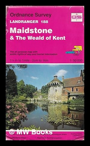
Maidstone & the Weald of Kent: the all purpose map with public rights of way and tourists information: 1 1/4 in to 1 mile - 2 cm to 1 km - 1: 50 000
Published by Southampton: Ordnance Survey, 1992
Revised Edition. Good map in original stiff card wrappers with some wear and tear as with age. Remains well-preserved overall; bright and clean. Physical description; 1 folding map. Subjects; Maidstone. The Weald of Kent. Tourist Maps. 1 Kg.
-
Landranger Maps: Maidstone and the Weald of Kent Sheet 188 (OS Landranger Map)
Published by Ordnance Survey, 1992
ISBN 10: 0319221881 ISBN 13: 9780319221884
Map. Condition: Used; Very Good. ***Simply Brit*** Welcome to our online used book store, where affordability meets great quality. Dive into a world of captivating reads without breaking the bank. We take pride in offering a wide selection of used books, from classics to hidden gems, ensuring there is something for every literary palate. All orders are shipped within 24 hours and our lightning fast-delivery within 48 hours coupled with our prompt customer service ensures a smooth journey from ordering to delivery. Discover the joy of reading with us, your trusted source for affordable books that do not compromise on quality.
-
Landranger No. 188 Maidstone & the Weald of Kent
Published by Ordnance Survey, 1745
ISBN 10: 0319221881 ISBN 13: 9780319221884
map. Condition: Used. Used. Ordnance Survey, undated, map, Ok Condition.
-
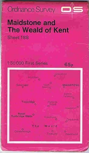
Maidstone and The Weald of Kent 1:50000 First series Sheet 188
Published by Ordnance Survey, Southampton, 1974
Map
Soft cover. Condition: Good. Maidstone and The Weald of Kent 1:50000 First series Sheet 188, 1974 edition. Map spit on folds, else clean.
-

Maidstone & the Weald of Kent: the all purpose map with public rights of way and tourists information: 1 1/4 in to 1 mile - 2 cm to 1 km - 1: 50 000
Published by Southampton: Ordnance Survey, 1992
Revised Edition. Good map in original stiff card wrappers with some wear and tear as with age. Remains well-preserved overall; bright and clean. Physical description; 1 folding map. Subjects; Maidstone. The Weald of Kent. Tourist Maps. 1 Kg.
-
![Seller image for Ordnance Survey sheet 6 [Rochester, Sevenoaks, Maidstone, Goudhurst - North Downs, Wealden Greensand, Low Weald, High Weald, Kent] for sale by Antiqua Print Gallery](https://pictures.abebooks.com/inventory/md/md31583234808.jpg)
Condition: Good. OS #6 Kent Downs & Weald. Rochester Sevenoaks Maidstone Tunbridge Wells 1819 map. Antique folding hand coloured survey map, dissected and laid down on linen; Engraved at the Ordnance Map Office, Tower of London. Engraved by Benjamin Baker and assistants. Writing by Ebenezer Bourne. Published by William Mudge. (1819). 66.0 x 97.0cm, 26 x 38.25 inches; this is a folding map. Condition: Good. Please contact us if you would like to arrange to view this map. There is nothing printed on the reverse side, which is plain. The genesis of the Ordnance Survey's original one-inch per mile survey occurred in 1783 when the Royal Societies of Paris and London agreed to connect their two great cities by the use of triangulation to settle the dispute of their relative positions. This triangulation, completed by 1790, together with the outbreak of war with France in 1793, acted as a catalyst for the surveying of England. The survey began in Kent and by the end of the Napoleonic Wars in 1815 most of southern England had been mapped. By 1844, publication of the Old Series, one inch to one mile, was complete for the whole of Great Britain south of Preston and Hull. In spite of concerns about the cost of the survey, work continued until by 1870 the whole of England and Wales had been mapped.