
Order Total (1 Item Items):
Shipping Destination:

L'isole Piu Famose Del Mondo by Porcacchi (19 results)
Skip to main search results
Product Type
- All Product Types
- Books (18)
- Magazines & Periodicals
- Comics
- Sheet Music
- Art, Prints & Posters (1)
- Photographs
- Maps
-
Manuscripts &
Paper Collectibles
Condition
Binding
Collectible Attributes
- First Edition (4)
- Signed
- Dust Jacket
- Seller-Supplied Images (14)
- Not Printed On Demand (14)
Free Shipping
Seller Location
Seller Rating
-
L'Isole Piu Famose del Mondo (Classic Reprint)
Published by Forgotten Books, 2018
ISBN 10: 0365981702ISBN 13: 9780365981701
Book Print on Demand
Paperback. Condition: New. Print on Demand. Excerpt from L'Isole Piu Famose del Mondo. About the Publisher, Forgotten Books publishes hundreds of thousands of rare and classic books. This book is a reproduction of an important historical work. Forgotten Books uses state-of-the-art technology to digitally reconstruct the work, preserving the original format whilst repairing imperfections present in the aged copy. In rare cases, an imperfection in the original, such as a blemish or missing page, may be replicated in our edition. We do, however, repair the vast majority of imperfections successfully; any imperfections that remain are intentionally left to preserve the state of such historical works. This text has been digitally restored from a historical edition. Some errors may persist, however we consider it worth publishing due to the work's historical value. The digital edition of all books may be viewed on our website before purchase. print-on-demand item.
More buying choices from other sellers on AbeBooks
New offers from � 14.30
-
![Seller image for L'isole piu famose del mondo descritte da Thomaso Porcacchi da Castiglione Arretino e intagliate da Girolamo Porro Padouano . 1590 [LeatherBound] for sale by True World of Books](https://pictures.abebooks.com/inventory/md/md31616463543.jpg)
LeatherBound. Condition: New. LeatherBound edition. Condition: New. Reprinted from edition. Leather Binding on Spine and Corners with Golden leaf printing on spine. Bound in genuine leather with Satin ribbon page markers and Spine with raised gilt bands. A perfect gift for your loved ones. NO changes have been made to the original text. This is NOT a retyped or an ocr'd reprint. Illustrations, Index, if any, are included in black and white. Each page is checked manually before printing. As this print on demand book is reprinted from a very old book, there could be some missing or flawed pages, but we always try to make the book as complete as possible. Fold-outs, if any, are not part of the book. If the original book was published in multiple volumes then this reprint is of only one volume, not the whole set. Sewing binding for longer life, where the book block is actually sewn (smythe sewn/section sewn) with thread before binding which results in a more durable type of binding. Pages: 224.
-
HRD. Condition: New. New Book. Shipped from UK. Established seller since 2000.
More buying choices from other sellers on AbeBooks
New offers from � 30.81
-
![Seller image for L'isole piu famose del mondo descritte da Thomaso Porcacchi da Castiglione . [LeatherBound] for sale by True World of Books](https://pictures.abebooks.com/inventory/md/md31533395158.jpg)
L'isole piu famose del mondo descritte da Thomaso Porcacchi da Castiglione . [LeatherBound]
Publication Date: 2023
Book Print on Demand
LeatherBound. Condition: New. LeatherBound edition. Condition: New. Reprinted from 1590 edition. Leather Binding on Spine and Corners with Golden leaf printing on spine. Bound in genuine leather with Satin ribbon page markers and Spine with raised gilt bands. A perfect gift for your loved ones. NO changes have been made to the original text. This is NOT a retyped or an ocr'd reprint. Illustrations, Index, if any, are included in black and white. Each page is checked manually before printing. As this print on demand book is reprinted from a very old book, there could be some missing or flawed pages, but we always try to make the book as complete as possible. Fold-outs, if any, are not part of the book. If the original book was published in multiple volumes then this reprint is of only one volume, not the whole set. Sewing binding for longer life, where the book block is actually sewn (smythe sewn/section sewn) with thread before binding which results in a more durable type of binding. Pages: 227 Language: Italian.
-
![Seller image for L'isole piu famose del mondo descritte da Thomaso Porcacchi da Castiglione arretino e intagliate da Girolamo Porro padovano con l'aggiunta di molte isole . [LeatherBound] for sale by True World of Books](https://pictures.abebooks.com/inventory/md/md31534218222.jpg)
LeatherBound. Condition: New. LeatherBound edition. Condition: New. Reprinted from 1576 edition. Leather Binding on Spine and Corners with Golden leaf printing on spine. Bound in genuine leather with Satin ribbon page markers and Spine with raised gilt bands. A perfect gift for your loved ones. NO changes have been made to the original text. This is NOT a retyped or an ocr'd reprint. Illustrations, Index, if any, are included in black and white. Each page is checked manually before printing. As this print on demand book is reprinted from a very old book, there could be some missing or flawed pages, but we always try to make the book as complete as possible. Fold-outs, if any, are not part of the book. If the original book was published in multiple volumes then this reprint is of only one volume, not the whole set. Sewing binding for longer life, where the book block is actually sewn (smythe sewn/section sewn) with thread before binding which results in a more durable type of binding. Pages: 241 Language: Italian.
-
![Seller image for L'isole piu famose del mondo descritte da Thomaso Porcacchi da Castiglione arretino e intagliate da Girolamo Porro padouano con noua aggionta . [LeatherBound] for sale by True World of Books](https://pictures.abebooks.com/inventory/md/md31534214231.jpg)
LeatherBound. Condition: New. LeatherBound edition. Condition: New. Reprinted from 1620 edition. Leather Binding on Spine and Corners with Golden leaf printing on spine. Bound in genuine leather with Satin ribbon page markers and Spine with raised gilt bands. A perfect gift for your loved ones. NO changes have been made to the original text. This is NOT a retyped or an ocr'd reprint. Illustrations, Index, if any, are included in black and white. Each page is checked manually before printing. As this print on demand book is reprinted from a very old book, there could be some missing or flawed pages, but we always try to make the book as complete as possible. Fold-outs, if any, are not part of the book. If the original book was published in multiple volumes then this reprint is of only one volume, not the whole set. Sewing binding for longer life, where the book block is actually sewn (smythe sewn/section sewn) with thread before binding which results in a more durable type of binding. Pages: 246 Language: Italian.
-
L'Isole piu famose del mondo descritte da Thomaso Porcacchi da Castiglione." - Titel title
Published by Venedig, Galignani, 1590
Seller: Antiquariat Steffen V�lkel GmbH, Seubersdorf, Germany
Seller Rating:

Art / Print / Poster
Original Kupferstich-Titel aus Tomaso Porcacchi's "L'isole piu famose del mondo" von 1590. -- Blatt-Ma�e: ca. 30 x 20 cm. -- leicht fleckig, sonst gut erhalten. || Original copper engraved title page from Tomaso Porchacchi's book "L'isole piu famose del mondo" from 1590. -- sligthly stained, otherwise in good condition. || Dies ist ein Original! - Kein Nachdruck! - Keine Kopie! | This is an original! - No reprint! - No copy! Sprache: Italienisch Gewicht in Gramm: 10.
-

L'Isole piu Famose del Mondo Descritte da Thomaso Porcacchi da Castiglione Arrentino e intagliate da Girolamo Porro Con l'Aggiunta di molte Isole.
Publication Date: 1604
Venice: Heirs of Simon Galignani, 1604. Folio, rebound in full vellum; pp. (xxii)+211; engraved title, 48 engraved maps in text, numerous woodcut emblems. Complete. Some restoration to edges of pages, with tip of the title plate affected. An example of the fourth edition (of seven) of one of the last notable isolario (atlas of islands). It was originally published in 1572 with only 30 maps, finely engraved by Girolamo Porro. The second edition of 1576 was expanded to 47 maps; this edition was the first to have the map of Istria included, the final addition to the atlas.
-
L'Isole piu Famose del Mondo.
Published by In Venetia : appr. Sim. Galignani e Gir. Porro, 1576
Book
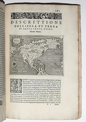
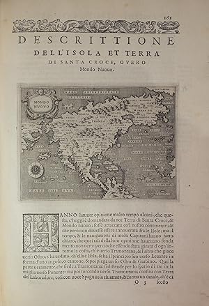
Hardcover. Condition: Good. Folio. 3 parts in 1. Bound in contemporary vellum, ink title, raised bands. Engraved title, 201 pp., wood-engraved printer's device on the last leaf, 47 half-page copperplate maps, including two world maps. Minor soiling and a few stains to vellum. Engraved title page trimmed and mounted, awkwardly colored with pastels, some damage to the page affecting the title (added in pencil). Scattered foxing, soiling. A few pages have paper reinforcements to marginal tears. Second and best edition of Porcacchi's famous Isolari book, including 17 maps not published in the first edition of 1572. The New World is represented from pages 154-184: "Descrittione della Gran Citta e isola Temistitan [Tenochtitlan]," with a plan; "Descrittione dell'isola et terra di Santa Croce, overo Mondo Nuouo." Porcacchi write extensively about the pre-conquest state of the Aztec culture. Contains a reduced version of Forlani's important map of North America first published in Venice in 1565, which was the first to show America as a single geographic entity. Descriptions of the islands of "Spagnvola", "Cvba", "Iamaica" or "S. Iacopo", "S. Lorenzo", and "S. Giovanni"or "Borichen," in five maps. The East Indies are as "Dell'Isole Molucche". Additionally, this edition is the first to provide the account of Jamaica. The two world maps at the end illustrate "Descrittione del Mappamondo," and "Discorso intorno alla Carta da navigare" Refs: Olschki, Choix, I 990. Adams P. 1905. Phillips 167. Sabin 64149. Alden/Landis 576/35. Borba de Moraes 685. Blackmer 1330. Leclerc 1192. Nordenskiold 187.
-
L'Isole piu famose del mondo.
Published by Georgio Angelieri for the heirs of Simone Galignan., Venice, 1590
First Edition
Three parts in one volume. Folio (11 6/8 x 8 1/8 inches). Engraved architectural title-page and 49 fine engraved maps in the text, including two world maps, by Girolamo Porro of Padua, wood-engraved printer's device on the last leaf, wood-engraved initials, head- and tail-pieces, all with later hand-colour in full. 17th-century vellum over paste-board (small tear at the foot of the spine). Third edition, much enlarged, including 19 maps not included in the first edition of 1572, and with two additional maps not included in the second edition of 1576: "Descrittione dell'Istria" and "Descrittione dell'isolla d'Elandia, isola de Gotti". The New World is represented from page 157: "Descrittione della Gran Citta e isola Temistitan," with a plan; "Descrittione dell'isola et terra di Santa Croce, overo Mondo Nuouo," with a reduced version of Forlani's very important map of North America first published in Venice in 1565, which was the first to show America as a single geographic entity, and is the second map to show the Strait of Anian in any detail; there are descriptions of the islands of "Spagnvola", "Cvba", "Iamaica" or "S. Iacopo", "S. Lorenzo", and "S. Giovanni"or "Borichen," with five maps. The islands of the Pacific are depicted in "dell'Isole Molucche". The two world maps at the end illustrate "Descrittione del Mappamondo," and "Discorso intorno alla Carta da navigare". The isolario, or book of islands, was a popular genre that had first appeared in manuscript examples by Cristoforo Buondelmonte dating from the early fifteenth century, then in printed versions by Bartolommeo dalli Sonetti from the late 1400s. More so than its predecessors, the isolario first published in 1528 by Venice-based cartographer Benedetto Bordone was formative for Renaissance geographical conceptions. Porcacchi, who was a prolific author of classical translations, genealogies, and poetry, gives detailed accounts of the geography and the history of each island. Adams P-1906; Alden and Landis 590/54; BMC Italian, p.534; Burden The Mapping of America 42; JCB (3) I:324; Sabin 64151; Shirley The Mapping of the World, pp. 127-128. Catalogued by Kate Hunter.
-
L'isole piu famose del Mondo.
Published by Heirs of Simon Galignani, Venice, 1590
Seller: Martayan Lan, New York, NY, U.S.A.
Seller Rating:

Hardcover. Condition: Very Good. Small folio [20.25 x 29.5], (6) (of 12) ff., including engraved title, 201, (1) pp., including 47 copper plate engraved maps in text. Note: bound contemporaneously without 2nd half of index (b signature). Complete with all maps. Bound in contemporary flexible vellum, borders of covers gilt-ruled with arabesque in center, spine gilt with double bands. Head of spine chipped, and some soling to covers. Engraved ex libris of Thomas Heath, Merchant of Exeter and another of the Western Reserve Historical Society, stamped withdrawn. Some soiling in outer margin of title and scattered leaves, faint waterstain in margin of others. Notwithstanding a fresh copy with the maps in excellent impression. Excellent enlarged edition of one of the most beautifully engraved Italian island books of the sixteenth century. L'isole piu famose was the first with maps engraved on copper; and with the Gastaldi edition of Ptolemy�s Geografia, 1548, it was among the few geographical works of any kind illustrated with engravings. This edition of Porcacchi contains much more than the first. According to Phillips Atlases it contains 17 maps not in the edition of 1572, including two relating to America: Jamaica and Puerto Rico, here called �Isola di S. Giovanni� for San Juan. Also included are maps of Spagnola and CUBA, Altogether, pages 154 to 184 relate to America. The volume closes with �Descrizione del Mappamondo� and �Discorso intorno alla carta da navigare,� pages 193 to 201, illustrated with two splendid Lafrerian-style maps of the world engraved by the Paduan Girolamo Porro. Porro, well-known as a book illustrator, later engraved maps for the first small-format Mercator atlas and for a Ptolemy (both appearing in 1596). According to Shirley, the oval-shaped world map �is a finely-executed reduction of Camocio�s large world map of 1567, one of the last in the long line of derivatives from Gastaldi's prototype of 1546.� * Adams P-1906; Sabin 64105; Shirley 127-28; see The World Encompassed 86.
-
L'Isole piu famose del mondo.
Published by Venice: Simone Galignani and Girolomo Porro, 1576., 1576
First Edition
Three parts in one volume. Small folio (11 3/4 x 8 inches). Engraved title-page (minor pale waterstain top edge), 47 fine engraved maps in the text by Girolamo Porro of Padua, including two world maps, woodcut printer's device on the last leaf, woodcut head- and tailpieces (small dampstain in the upper margin affecting the text of the first few leaves). Contemporary limp vellum (lacking two pairs of ties, lightly soiled, a few pale stains). Provenance: early manuscript bibliographical note on front paste-down. Second and best edition including 17 maps not published in the first edition of 1572. A charming and popular 16th-century atlas that depicts the world as a series of islands. The New World is represented from page 154: "Descrittione della Gran Citta e isola Temistitan," with a plan; "Descrittione dell'isola et terra di Santa Croce, overo Mondo Nuouo," with a reduced version of Forlani's very important map of North America first published in Venice in 1565, which was the first to show America as a single geographic entity, and is the second map to show the Strait of Anian in any detail; there are descriptions of the islands of "Spagnvola", "Cvba", "Iamaica" or "S. Iacopo", "S. Lorenzo", and "S. Giovanni"or "Borichen," with five maps. The islands of the Pacific are depicted in "dell'Isole Molucche". The two world maps at the end illustrate "Descrittione del Mappamondo," and "Discorso intorno alla Carta da navigare". Adams P-1905; Alden-Landis 576/35; Phillips, Atlases 167; Sabin 64149.
-
L'Isole Piu Famose Del Mondo. Con L'Aggiunta di Molte Isole.
Published by Venice: Simon Galignani and Girolamo Porro, 1576, 1576
Seller: Peter Harrington. ABA/ ILAB., London, United Kingdom
Association Member: ABA ILAB PBFA
Seller Rating:
Second and best edition, which contains "much more" (Sabin) than the first edition of 1572, including 17 additional maps. Two of these, Jamaica and Porto Rico, are in the eight-map section on the New World, which also includes a reduced version of Forlani's 1565 map, the first to show America as a single geographical entity, Temistitan (Mexico), Cuba, and others. The last two maps, "Descrittione del Mappamondo," and "Discorso intorno alla Carta da navigare" are "a finely-executed reduction of Camocio's large world map of 1567. [&] a nautical map covering most of the world" (Shirley). Both show a vast southern continent "terra incognita", and the latter is accompanied by a brief navigational text with information on winds and currents. The superb engraving is the work of the joint publisher, Girolamo Porro, Paduan artist-illustrator-engraver, who illustrated the 1584 Venice edition of Ariosto's Orlando Furioso and Porcacchi's Funerali antichi di diversi Popoli et Natione, and engraved maps for Magini's 1596 edition of Ptolemy's Geographia and Mercator's Atlas Minor of the same year. Two variants have been observed in the edition, but no priority between them has been established; the present copy has p. 13, line 10 ending 'mara' and line 11 beginning 'uigliosa'. Adams P-1905; Phillips 167; Sabin 64149; Shirley 127-28. Folio (285 x 198 mm). Near-contemporary limp vellum, renewed endpapers. Engraved title, and 47 half-page engraved maps by Porro after Poracchi, wood-engraved opening initials, head and tail-pieces, and printer's device at end. A hint of wear, small ink stains to bottom edge, renewed endpapers, light soiling, creases to bottom corner of ff. K3-4, pen trials to bottom margin of p. 58; still, a very good copy.
-

L'Isole piu famose del Mondo.
Published by Venice, Simon Galignani & Girolamo Porro, 1572
Seller: Mayfair Rare Books & Manuscripts Ltd, London, United Kingdom
Association Member: ABA ALAI ILAB
Seller Rating:
Book First Edition
Hardcover. Condition: Good. Folio (290 x 200 mm), attractive 17th cent. red morocco binding with double border of thin fillets gilt to covers, with corner tools, and gilt to centre the coat-of-arms of the Piedmontese family Turinetti di Prierio, gilt spine with raised bands (carefully redone to style), flyleaves and pastedowns in marbled paper, large 18th century engraved bookplate at inner side of upper cover, generally a clean copy, in very good condition. Some cont. annotations at margin of p. 1 of text. Fine engraved architectural title-page incorporating figures, putti, armillary sphere and globes, printer's woodcut device on recto of last leaf (upper corner carefully restored), woodcut initials, pp. (24 nn.), 117, (1), finely illustrated with 30 finely executed half-page maps by Girolamo Porro of islands and continents, in dark impression. A very good, large copy. First edition of one of the most celebrated books of islands, with the fine engravings Girolamo Porro, who also produced the maps for Ruscelli's translation of Ptolemy's Geographia in 1574. The first 15 maps are depicting Venice and the islands of the Mediterranean (Corfu, Crete, Cyprus, Rhodes, Sicily, Malta, Corsica, etc), then 6 from Northern Europe, the British Isles, Scotland, Ireland, the Frisian islands, Iceland , then across the Atlantic, Hispanola, Cuba and Ceylon and the Moluccas in the Pacific. The last 4 engr. inc. a detailed map of North America, a plan of Mexico city and two world maps, BMC STC It. p. 534; Sabin 64148; Alden/L. 572/44; Palau 232891, not in Mortimer Harv. Italian.
-
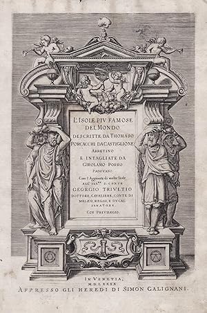
L'isole piu famose del Mondo. Arettino e intagliate da Girolamo Porro Padovano. Con l'aggiunta di molte isole all' ill.re s. conte Georgio Trivltio. - [THE CULMINATION OF THE "BOOK OF ISLANDS"]
First Edition
Venetia [Venice], apresso gli heredi di S. Gagliani, 1590. [Colophon: In Vintia, appresso Giorgio Angelieri, a instantia de gli heredi di Simon Gagliani de Karera, 1590]. Small folio. 18th century (ab. 1780-90) half vellum with gilt leather title label to spine. Corners a bit bumped and title label a bit worn, otherwise nice and tight. A very nice copy, on thick, crisp paper. A few quires browned and brownspotted, and some occasional lighter browning. Four leaves with a marginal worm-tract, far from affecting text. Beautiful engraved title-page, consisting of a wide architectural border illustrated with large figures, putti, globes, and various symbols. Beautiful large woodcut initials and head- and tail-pieces. 47 half-page engraved maps in the text (by Porro, of islands and continents), excellent, crisp impressions. Large woodcut device to colophon. (12) ff., 201, (1) pp. Third, much enlarged edition (with 47 maps as opposed to the mere 30 of the first edition) of Porcacchi's great book of islands, arguably the most famous of all "isolario"s, with the 47 finely engraved maps by the famous map-maker Girolamo Porro, which also include maps of non-insular places, e.g North America and Mexico City, the famous city plan of Venice and that of Constantinople. Porcachhi's great "isolario" represents the culmination of the "book of islands"-genre, both in regards to artistic quality and the information provided. It furthermore constitutes a main work in the history of the published knowledge of farther parts of the world and an important link in the development from what we call the "book of islands" to the modern atlas. As such it is of great value in several respects, both historically, culturally, and cartographically. "The "book of islands," or isolario, a novel form of cartographic book combining maps and narrative-historical chorography, was invented and initially developed in Italy during the fifteenth and sixteenth centuries. According to R.A. Skelton, "like the portolano, or pilot-book, to which it was related, it had its origins in the Mediterranean, as an illustrated guide for travelers in the Aegean Archipelago and the Levant.". The first "book of islands" was authored by a Florentine ecclesiastic [around 1420] named Cristoforo Buondelmonti [.].The "book of islands" was eventually superseded as a cartographic genre, as was the "Geographia" of Ptolemy, by the modern atlas" it persists even after Abraham Ortelius's 1570 "Theatrum orbis terrarium", but at the margins rather than at the center of the history of cartography. While the "isolario", Ptolemy's "Geographia", and the "modern" atlas coexist for some time, the gradual eclipse of the "book of islands" at one level reflected a progressive decentering of the Mediterranean that occurred within the broader context of early modern history, following the Atlantic discoveries. But well before that happened, in conjunction with the culminating moment of the discoveries and exploration period and at the height of the high Renaissance, the second printed "book of islands" appeared in 1528 in Venice published by Zoppino: the "Libro di Benedetto Bordone nel qual si ragiona de tutte l'isole del mondo" [Book of Benedetto Bordone in which are discussed all the islands of the world]. As the title suggests, this "isolario" provided even broader coverage than the Martellus recensions of Buondelmonti and gave special prominence to the islands of the New World [.].Da li Sonetti's translation of Buondelmonti's "book of islands" into a cycle of sonnets in Venice represented in its way an expression of the same desire to reconcile contemporary geographical knowledge to Italian vernacular traditions of geographical poetry that Berlinghieri's poetic Ptolemy expressed. But while the tradition of Tuscan geographical poetry would not survive the Quattrocento, the prose book of islands did, thanks especially to the Venetian print culture that was responsible for da li Sonetti and that produced Bordone's High Renaissance print "isolario". As mentioned, the print genre "book of islands" would endure in fact, albeit at the margins of modern cartography and literature, in multiple editions of Bordone, which were followed by the no less successful Tommaso Porcacchi's "L'isole pi� famose del mondo" (1572" with copper-plate engravings), a line that continued through the seventeenth century [.] But just as with other major literary fields of endeavor including the political (Machiavelli), the pastoral (Sannazzaro), the courtly-bureaucratic (Castiglione), and the epic-novellistic (Ariosto), the "isolario" produced its masterpieces in the discoveries and travel writing field(alongside Columbus, Vespucci, and Verrazzano) during the High Renaissance." (Cachey, "From the Mediterranean to the World: A Note on the Italian "Book of Islands" ("isolario")", pp. 1-10). Shirley T.POR-1d" Phillips: 50.
-
L'Isole piu famose del Mondo.
Publication Date: 1590
Couverture rigide. Condition: Tr�s bon. Venetia, Heredi di Simon Galignani, 1590.In-folio de (3) ff.bl., (12) ff., 201 pp., (1) p., (1) f.bl. Un frontispice grav�, 47 cartes sur cuivre et la marque de l'imprimeur � la fin. Qq. ff. piqu�s. Conserv� dans son v�lin souple de l'�poque � petits rabats, dos lisse avec quelques manques, titre manuscrit sur la tranche inf�rieure. Reliure de l'�poque.310 x 214 mm. --- Troisi�me �dition largement augment�e de ce c�l�bre atlas, illustr�e de 47 cartes soit 17 de plus que dans la premi�re de 1572. Leclerc, Bibliotheca Americana, n�461�; Sabin 64150�; Adams 1906. Les pages 157 � 184 sont consacr�es � l'Am�rique et contiennent� ��Descrittione della Gran Citta e isola Temistitan�� et �� Descrittione dell'Isola et terra di Santa Croce, overo Mondo Nuovo�� avec une version r�duite de la tr�s importante carte de l'Am�rique du Nord publi�e par Forlani � Venise en 1565, la premi�re carte � montrer l'Am�rique comme une entit� g�ographique � part enti�re, et la seconde carte � montrer de mani�re d�taill�e le d�troit d'Anian. Ces pages pr�sentent encore les descriptions d'Ha�ti, de Cuba, de la Jama�que, de S. Iacopo, de S. Lorenzo, de S. Giovanni avec 5 cartes. L'ouvrage s'ach�ve sur ��Descrittione del Mappamondo�� et ��Discorso intorno alla Carta da navigare�� pp. 193-201 avec 2 cartes du monde. La majeure partie des textes consacr�s ici � l'Am�rique parait ici pour la premi�re fois. Cette troisi�me �dition comporte 2 cartes qui paraissent ici pour la premi�re fois, absentes de la seconde �dition de 1576�: ��Descrittione dell'Istria�� et ��Descrittione dell'Isola d'Elandia, isola de Gotti��. L'illustration comporte 1 titre imprim� dans un cadre architectural orn� de symboles cartographiques, la marque de l'imprimeur au verso du dernier feuillet, et 47 cartes finement grav�es sur cuivre. Les 47 cartes de Girolamo Porro, c�l�bre /// Venetia, Heredi di Simon Galignani, 1590.Folio [310 x 214 mm] of (3) bl.ll., (12) ll., 201 pp., (1) p., (1) bl.l. An engraved frontispiece, 47 copper engraved �maps and the printer's mark at the end. Some slight foxing. Preserved in its contemporary limp vellum with small flaps, flat spine with small portions missing, handwritten title on the lower edge. Contemporary binding. --- Third edition widely enlarged of this famous atlas, illustrated with 47 maps, that is to say 17 more than in the First edition of 1572. Leclerc, Bibliotheca Americana, n�461; Sabin 64150�; Adams 1906. Pages 157 to 184 are dedicated to America and contain ��Descrittione della Gran Citta e isola Temistitan�� and ��Descrittione dell'Isola et terra di Santa Croce, overo Mondo Nuovo�� with a reduced version of the very important map of North America published by Forlani in Venice in 1565, the first map to show America as a geographic entity of its own, and the second map to show in details the Strait of Anian. These pages also present the descriptions of Haiti, Cuba, Jamaica, of S. Iacopo, S. Lorenzo, S. Giovanni with 5 maps. The book concludes with ��Descrittione del Mappamondo�� and ��Discorso intorno alla Carta da navigare�� pp. 193-201 with 2 world maps. The greater part of the texts dedicated here to America is published here for the first time. This third edition contains 2 maps that are published here for the first time, absent from the 1576 second edition: ��Descrittione dell'Istria�� and ��Descrittione dell'Isola d'Elandia, isola de Gotti��. The illustrations consist of 1 title printed in an architectural border decorated with cartographic symbols, the printer's mark at the back of the last leaf, and 47 finely copper-engraved maps. The 47 maps of Girolamo Porro, a famous member of the Italian School, are superbly drawn. An attractive pure copy particularly wide margined (height: 310 mm), one of th.


![Seller image for L'isole piu famose del Mondo. Arettino e intagliate da Girolamo Porro Padovano. Con l'aggiunta di molte isole all' ill.re s. conte Georgio Trivltio. - [THE CULMINATION OF THE "BOOK OF ISLANDS"] for sale by Lynge & S�n ILAB-ABF](https://pictures.abebooks.com/inventory/md/md8947875190.jpg)
