Order Total (1 Item Items):
Shipping Destination:

Japan Map by Bartholomew John (15 results)
Skip to main search results
Product Type
- All Product Types
- Books (9)
- Magazines & Periodicals
- Comics
- Sheet Music
- Art, Prints & Posters
- Photographs
- Maps (6)
- Manuscripts & Paper Collectibles
Condition
Binding
- All Bindings
- Hardcover
- Softcover (7)
Collectible Attributes
- First Edition (1)
- Signed
- Dust Jacket
- Seller-Supplied Images (14)
- Not Print on Demand (15)
Free Shipping
- Free US Shipping
Seller Location
Seller Rating
-
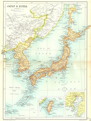
Condition: Good. JAPAN & KOREA. Inset maps of Taiwan; Tokyo. Cassells 1909 old antique. Antique coloured map ; John Bartholomew & Co; drawn by The Edinburgh Geographical Institute (1909). 34.0 x 25.5cm, 13.25 x 10 inches; this is a folding map. Condition: Good. The image shown may have been taken from a different example of this map than that which is offered for sale. The map you will receive is in good condition but there may be minor variations in the condition from that shown in the image. There is nothing printed on the reverse side, which is plain.
-
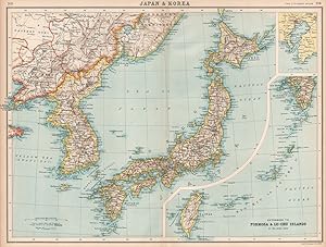
Japan & Korea; Inset maps of Tokio; Extension to Formosa & Lu-Chu Island on the same scale
Publication Date: 1901
Map
Condition: Good. JAPAN & KOREA. Inset Tokyo bay. Formosa Taiwan. Railways. BARTHOLOMEW 1901 map. Antique colour map; John Bartholomew (1901). 33.0 x 43.5cm, 13 x 17 inches; this is a folding map. Condition: Good. There is nothing printed on the reverse side, which is plain.
-
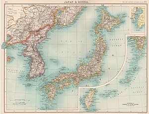
Japan & Korea; Inset maps of Tokio; Extention to Formosa & Lu-Chu Islands
Publication Date: 1912
Map
Condition: Good. JAPAN & KOREA. Inset Tokyo bay. Formosa Taiwan. Railways. BARTHOLOMEW 1912 map. Antique colour atlas map; John Bartholomew & Co., Edin. (1912). 33.5 x 44.0cm, 13 x 17.25 inches; this is a folding map. Condition: Good. There is nothing printed on the reverse side, which is plain.
-
Softcover. Condition: Very Good. 1899. A clean and very well-presented 1899 colour printed map, unmarked across the entire image surface, and with a central fold line as originally presented but no other notable creases or wear. Why on Amazon do most sellers not describe their actual book? Buy with confidence and support a genuine Independent Bricks & Mortar Real Bookshop. We are Maynard & Bradley CAMBO & PBFA(now lapsed) members here in Leicester City Centre. Size: 365 x 470 mm. 1. Item Type: Book. Quantity Available: 1. Shipped Weight: Under 500 grams. Category: Geography & Maps; Britain/UK; 19th century; Inventory No: 42142.
-
Softcover. Condition: Very Good. 1899. A clean and very well-presented 1899 colour printed map, unmarked across the entire image surface, and with a central fold line as originally presented but no other notable creases or wear. Why on Amazon do most sellers not describe their actual book? Buy with confidence and support a genuine Independent Bricks & Mortar Real Bookshop. We are Maynard & Bradley CAMBO & PBFA(now lapsed) members here in Leicester City Centre. Size: 365 x 470 mm. 1. Item Type: Book. Quantity Available: 1. Shipped Weight: Under 500 grams. Category: Geography & Maps; Britain/UK; 19th century; Inventory No: 42143.
-
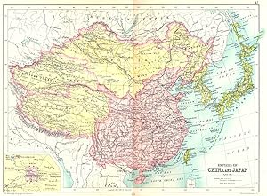
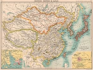
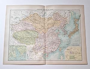
Condition: Good. CHINA & JAPAN. Empires; Inset Beijing Peking. Tibet Mongolia Manchuria 1909 map. Antique coloured map ; John Bartholomew & Co; drawn by The Edinburgh Geographical Institute (1909). 24.0 x 33.0cm, 9.5 x 13 inches; this is a folding map. Condition: Good. The image shown may have been taken from a different example of this map than that which is offered for sale. The map you will receive is in good condition but there may be minor variations in the condition from that shown in the image. There is nothing printed on the reverse side, which is plain.
-
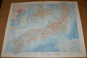
Map of Japan - Plate 19 disbound from 1958 Mid-Century Times Atlas of the World, with Iwo Jima and Okinawa and inset plan of Tokyo Bay
Published by The Times Publishing Company Ltd., London, 1958
Softcover. Condition: Very Good. Dust Jacket Condition: No Dust Jacket. Mid-Century Edition. Single disbound map sheet from 'The Times Atlas of the World, Mid-Century Edition; Volume I The World, Australia & East Asia' suitable for framing. Map is in colour and has vertical centre fold. Approx sheet size is 49 x 61cm. Sheet is clean, bright and crisp. Map covers Japan, with Hokkaido included as an inset contiuation panel. Sheet contains small inset plans showing Iwo Jima and Okinawa at closer scales and a plan of Tokyo Bay (including Tokyo, Yokohama, Kawasaki, Yokosuka and Chiba). Road and railway routes are shown. First printing of this edition. Quantity Available: 1. Shipped Weight: under 1 kg. Pictures of this item not already displayed here available upon request. Inventory No: 45021024043. For International tracked shipping please select the Priority shipping service.
-
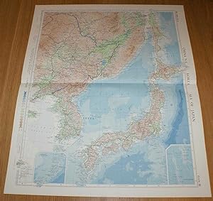
Map of North East China, Korea, Sea of Japan and Japan - Plate 20 disbound from 1958 Mid-Century Times Atlas of the World, including Vladivostock, Khabarovsk, Harbin, Pyongyang, Seoul, Pusan, Osaka and Tokyo
Published by The Times Publishing Company Ltd., London, 1958
Softcover. Condition: Very Good. Dust Jacket Condition: No Dust Jacket. Mid-Century Edition. Single disbound map sheet from 'The Times Atlas of the World, Mid-Century Edition; Volume I The World, Australia & East Asia' suitable for framing. Map is in colour and has horizontal centre fold. Approx sheet size is 61 x 49cm. Sheet is clean, bright and crisp. Map covers north east China, Korea, Sea of Japan, Japan and parts of eastern Russia (USSR). Included are Vladivostock, Khabarovsk, Harbin, Pyongyang, Seoul, Pusan, Osaka, Tokyo, Sakhalin, Shenyang, etc. Road and railway routes are shown. First printing of this edition. Quantity Available: 1. Shipped Weight: under 1 kg. Pictures of this item not already displayed here available upon request. Inventory No: 45021024044. For International tracked shipping please select the Priority shipping service.
-
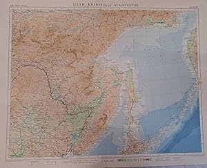
Map of U.S.S.R. Khabarovsk, Vladivostok, Plate 40 disbound from 1959 Mid-Century Times Atlas of the World, Volume II, (South-West Asia & Russia) Scale 1: 5,000,000. Includes small part of Japan
Published by The Times Publishing Company Ltd., London, 1959
Softcover. Condition: Fine. Dust Jacket Condition: No Dust Jacket. Mid-Century Edition. Single disbound map sheet from 'The Times Atlas of the World, Mid-Century Edition; Volume II Eurasia, suitable for framing. Map is in colour and has vertical centre fold. Approx. sheet size is 49 x 61cm. Sheet is clean, bright and crisp. Scale 1:5,000,000. Includes Kurilskiye Ostrova (Kuril Islands) and its volcanoes. Map shows relief, Oblast and Kray Boundaries, cities, town, rivers, main roads, railways, main civil airports and other airfields, active volcanoes. Key map on reverse and glossary of Russian Geographical Terms and Abbreviations of Principal Soviet Administrative Areas. First printing of this edition. Quantity Available: 1. Shipped Weight: under 1 kg. Pictures of this item not already displayed here available upon request. Inventory No: 45022081073. For International tracked shipping please select the Priority shipping service.
-
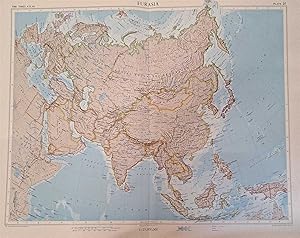
Map of 'Eurasia' - Plate 25 disbound from 1959 Mid-Century Times Atlas of the World, Volume II South-West Asia and Russia including Union of Soviet Socialist Republics, United Kingdom, Somalia, Japan, China, India, Borneo, Europe etc.
Published by The Times Publishing Company Ltd., London, 1959
Softcover. Condition: Fine. Dust Jacket Condition: No Dust Jacket. Mid-Century Edition. Single disbound map sheet from 'The Times Atlas of the World, Mid-Century Edition; Volume II Eurasia, suitable for framing. Map is in colour and has vertical centre fold. Approx sheet size is 49 x 61cm. Sheet is clean, bright and crisp. Scale 1:25,000,000 Map covers: United kingdom, Ireland and mainland Europe; North-east Africa including Egypt, Ethiopia, Somalia and Somaliland, Ethiopia, Nubia, Eritrea, Tunisia, parts of Sudan, Libya, Algeria, Morocco, Uganda, Kenya, Tanganyika, Mocambique, Madagascar; Middle East including Arabia, Yemen, Aden, Muscat & Oman, Trucial Oman, Israel, Lebanon, Jordan, Syria, Turkey, Iraq, Iran, Iran, Kuwait, Qatar; Indian Sub-Continent including India, Ceylon, Pakistan, East Pakistan, Afghanistan. Nepal; Soouth-East Asia including Burma, Thailand, Laos, Vietnam, Cambodia, Philippeans, Sarawak, Borneo, Sumatra, Java, New Guinea, Malaya, Singapore, Adaman Islands; Central Asia including China, Mongolia, Japan, Korea, Tainan, Hong King; Ocean including Caroline Islands; Marianas or Ladrones Islands, Marcus Island, Guam, Admiralty Island; Union of Soviet Socialist Republics; small part of Australia. First printing of this edition. Quantity Available: 1. Shipped Weight: under 1 kg. Pictures of this item not already displayed here available upon request. Inventory No: 45022081059. For International tracked shipping please select the Priority shipping service.
-
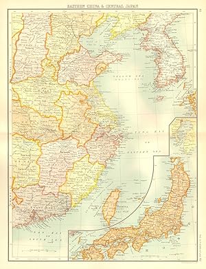
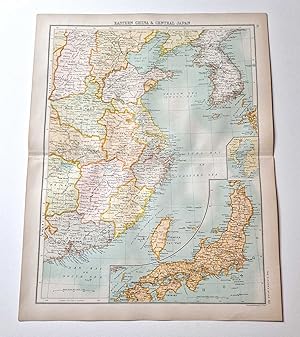
Condition: Good. EAST ASIA. Eastern China Central Japan Korea. BARTHOLOMEW 1898 old antique map. Antique colour map; John Bartholomew (1898). 43.5 x 32.5cm, 17 x 12.75 inches; this is a folding map. Condition: Good. The image shown may have been taken from a different example of this map than that which is offered for sale. The map you will receive is in good condition but there may be minor variations in the condition from that shown in the image. There is nothing printed on the reverse side, which is plain.
-
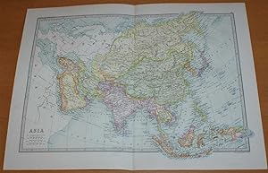
Map of Asia - Sheet 41 disbound from the 1890 'The Library Reference Atlas of the World' with the Chinese, Turksish and Russian Empires, India, Persia, Arabia, Siam, Malaysia, Japan, etc.
Published by Macmillan and Co., London, 1890
First Edition
Softcover. Condition: Very Good. Dust Jacket Condition: No Dust Jacket. First Edition. Single disbound coloured map sheet, from John Bartholomew's Library Reference Atlas. Suitable for framing. Approx size 35 x 46cm, vertical centre fold. Occasional light foxing in margins, map is otherwise clean, crisp and bright. Countries are coloured in various pastel shades. Map covers whole of Asia from the Arctic Ocean to Java. Included are Russian Empire, Siberia, Mongolia, Chinese Empire, Tibet, Corea, Japan, Turkish Empire, Persia, Arabia, Afghanistan, India, Burma, Siam, Cochin China, Malaysia, Borneo, New Guinea, Sumatra, Ceylon and Beloochistan. Surrounding parts of Europe and Africa are mapped but not coloured. No dust jacket, as published. Quantity Available: 1. Shipped Weight: under 1 kg. Pictures of this item not already displayed here available upon request. Inventory No: 45021014041. For International tracked shipping please select the Priority shipping service.
-
Condition: Good. EAST ASIA. China Chinese Turkistan Tibet Korea Japan. HK Peking Beijing 1901 map. Antique colour map; John Bartholomew (1901). 32.0 x 43.0cm, 12.75 x 17 inches; this is a folding map. Condition: Good. There is nothing printed on the reverse side, which is plain.
-
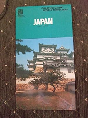
Japan Map (World Travel S.)
Published by Bartholomew, 1980
ISBN 10: 070280245XISBN 13: 9780702802454
Book
Condition: LikeNew. Most items will be dispatched the same or the next working day.
More buying choices from other sellers on AbeBooks
Used offers from � 77.27