
Order Total (1 Item Items):
Shipping Destination:

Insulae Danicae Mari Balthico Sitae (6 results)
Skip to main search results
Product Type
- All Product Types
- Books (3)
- Magazines & Periodicals
- Comics
- Sheet Music
- Art, Prints & Posters (2)
- Photographs
- Maps (1)
-
Manuscripts &
Paper Collectibles
Condition
- All Conditions
- New
- Used
Binding
- All Bindings
- Hardcover
- Softcover
Collectible Attributes
- First Edition
- Signed
- Dust Jacket
- Seller-Supplied Images (2)
- Not Printed On Demand
Seller Location
Seller Rating
-
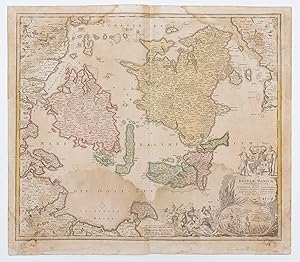
Insulae Danicae in Mari Balthico Sitae utpote Zeelandia, Fionia, Langelandia, Lalandia, Falstria, Fembria Mona
Published by Nuremberg, 1789
Seller: Robert Frew Ltd. ABA ILAB, London, United Kingdom
Association Member: ABA ILAB PBFA
Seller Rating:

Map
Double page (49 x 57 cm.) engraved map with original hand-colour. Some dampstaining.
-

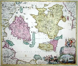
Insulae Danicae in mari Balthico Sitae, utpte Zeelandia, Fionia, Langelandia, Lalandia, Falstria, Fembria Mona.". Landkarte. Altkolorierter Kupferstich von J. B. Homann nach J. H�bner. Mit gro�er dekorativer Kartusche (Meerjungfrauen, Segelschiffe mit Ansicht vom Sund / Kopenhagen u. a. K�stenst�dte, Wappen).
Published by [N�rnberg ca. ]., 1730
Seller: WILFRIED MELCHIOR � ANTIQUARIAT & VERLAG, Spreewaldheide, Germany
Seller Rating:
Art / Print / Poster
Ca. 50,5 x 59,0 cm. - Ganz oben mit Wurmspur. Sehr dekorative Karte der d�nischen Inseln, mit F�nen, Lolland, Falster, Seeland. K�benhavn. - Mit grenzkolor. Darstellung der zeitweise auch d�nischen Insel Fehmarn.
-
. Altkolorierter Kupferstich. 49 cm x 54 cm. N�rnberg. * Karte von D�nemark und den d�nischen Inseln, mit F�nen, Lolland, Falster, Seeland. Mit gro�er dekorativer Kartusche (Meerjungfrauen, Segelschiffe mit Ansicht vom Sund Kopenhagen und anderen K�stenst�dten, Wappen). (K).
-
Insulae Danicae in Mari Balthico Sitae .
Seller: Kunstantiquariat Beisler, Weilheim i. Ob., Germany
Seller Rating:
Fl�chenkolorit Kupferstich- Landkarte v. Joh. Bapt. Homann b. N�rnberg, um 1720, 51 x 59,5 cm. Zeigt die d�nischen Inseln. Unten rechts sehr dekorative Kartusche mit m�rchenhaften Wasserwesen, Herrschaftswappen und einer Miniaturdarstellung der wichigsten d�nischen St�dte.- Leichter Abdruck des Grenzkolorits des gegen�berliegenden Teils der Karte, hervorgerufen durch das Zusammenfalten der Karte. Gut erhalten. Dekoratives Blatt. JPEG-Bilder auf Anfrage m�glich. Denmark. "Insulae Danicae .". Copperplate engraved map by J. B. Homann, Nuremberg, ca. 1720. 51 x 59.5 cm. JPEG pictures upon request. Map shows islands of Denmark.In the right corner at the bottom very decorative cartouche with fairy tale like water creatures, coat of arms and miniature depiction of the most important cities of Denmark.-Slight copy of the colours of the period coloured boundaries of the obverse part of the map, occured by the use of folding of the map. In a good condition. Decorative sheet !.
-
D�NEMARK. - Inseln. - Karte. "Insulae Danicae in Mari Balthico sitae . Zeelandia, Fionia, Langelandia".
Seller: Peter Bierl Buch- & Kunstantiquariat Inh.: Andrea Bierl, Eurasburg, Germany
Seller Rating:
Art / Print / Poster
Altkol. Kupferstich von Johann Baptist Homann, um 1720, 50 x 58 cm. Sch�ne, fl�chenkolorierte Gesamtkarte der d�nischen Inselwelt. Mit gro�er fig�rlicher Kartusche rechts unten.
-
Insulae Danicae in mari Balthico sitae utpote Zeelnadia, Fionia, Langelandia,Lalandia,Falstria, Fembria Mona
Published by Artist: Homann Johann Babtiste ( - 1724 ) Nuremberg ; issued in: Nuremberg ; ca: 1720; - Johann Babtiste Homann (1664-1724) Nuremberg was born in Oberkammlach the Electorate of Bavaria Although educated at a Jesuit school and preparing for an ecclesiastical career he eventually converted to Protestantism and from 1687 worked as a civil law notary in Nuremberg He soon turned to engraving and cartography; in 1702 he founded his own publishing house Homann acquired renown as a leading German cartographer and in 1715 was appointed Imperial Geographer by Emperor Charles VI Giving such privileges to individuals was an added right that the Holy Roman Emperor enjoyed In the same year he was also named a member of the Prussian Academy of Sciences in, 1664
Seller: Antique Sommer& Sapunaru KG, M�nchen, Germany
Seller Rating:

Technic: Copper print; colorit: colored; condition: Very good, size (in cm): 49 x 58; - Map shows the islands of Denmark.
