Order Total (1 Item Items):
Shipping Destination:

Greater London Plan 1944 by Abercrombie (30 results)
Feedback
Skip to main search results
Search filters
Product Type
- All Product Types
- Books (20)
- Magazines & Periodicals (No further results match this refinement)
- Comics (No further results match this refinement)
- Sheet Music (No further results match this refinement)
- Art, Prints & Posters (No further results match this refinement)
- Photographs (No further results match this refinement)
- Maps (10)
- Manuscripts & Paper Collectibles (No further results match this refinement)
Condition
Binding
- All Bindings
- Hardcover (18)
- Softcover (No further results match this refinement)
Collectible Attributes
- First Edition (9)
- Signed (No further results match this refinement)
- Dust Jacket (5)
- Seller-Supplied Images (24)
- Not Print on Demand (28)
Free Shipping
Seller Rating
-
Condition: Good. GREATER LONDON PLAN. England & Wales road traffic density. ABERCROMBIE 1944 map. Vintage colour town planning map; Patrick Abercrombie (1944). 23.0 x 21.0cm, 9 x 8.25 inches. Condition: Good. The image shown may have been taken from a different example of this map than that which is offered for sale. The map you will receive is in good condition but there may be minor variations in the condition from that shown in the image. There are images and/or text printed on the reverse side of the picture. In some cases this may be visible on the picture itself or around the margin of the picture.
-
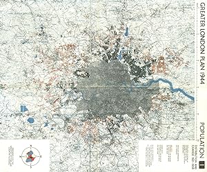
Condition: Good. GREATER LONDON. Population change up/down 1921-1938. ABERCROMBIE 1944 old map. Vintage colour town planning map; Patrick Abercrombie (1944). 50.0 x 41.5cm, 19.5 x 16.25 inches; this is a folding map. Condition: Good. The image shown may have been taken from a different example of this map than that which is offered for sale. The map you will receive is in good condition but there may be minor variations in the condition from that shown in the image. There is nothing printed on the reverse side, which is plain.
-
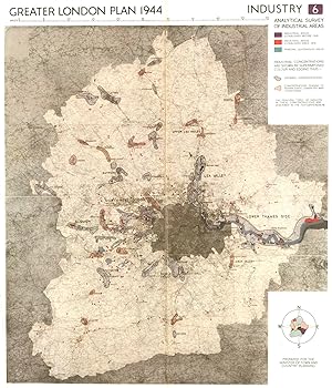
Greater London Plan 1944; Industry. Analytical survey of industrial areas
Publication Date: 1944
Map
Condition: Good. GREATER LONDON. Development of industrial areas to 1939. ABERCROMBIE 1944 map. Vintage colour town planning map; Patrick Abercrombie (1944). 49.5 x 42.5cm, 19.5 x 16.75 inches; this is a folding map. Condition: Good. The image shown may have been taken from a different example of this map than that which is offered for sale. The map you will receive is in good condition but there may be minor variations in the condition from that shown in the image. There is nothing printed on the reverse side, which is plain.
-
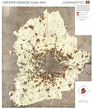
Greater London Plan 1944; Communities. Built-up areas and open land in 1939
Publication Date: 1944
Map
Condition: Good. GREATER LONDON. Built-up areas & open land in 1939. ABERCROMBIE 1944 old map. Vintage colour town planning map; Patrick Abercrombie (1944). 50.0 x 41.5cm, 19.5 x 16.25 inches; this is a folding map. Condition: Good. The image shown may have been taken from a different example of this map than that which is offered for sale. The map you will receive is in good condition but there may be minor variations in the condition from that shown in the image. There is nothing printed on the reverse side, which is plain.
-
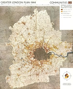
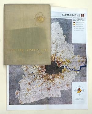
Greater London Plan 1944; Communities. Sporadic Growth of Communities from 1918 to 1939
Publication Date: 1944
Map
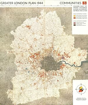
Condition: Good. GREATER LONDON. Housing built <1918, 1918-1939. ABERCROMBIE 1944 old map. Vintage colour town planning map; Patrick Abercrombie (1944). 50.0 x 41.0cm, 19.75 x 16.25 inches; this is a folding map. Condition: Good. The image shown may have been taken from a different example of this map than that which is offered for sale. The map you will receive is in good condition but there may be minor variations in the condition from that shown in the image. There is nothing printed on the reverse side, which is plain.
-
Condition: Good. GREATER LONDON. Private & public housing built 1918-1939. ABERCROMBIE 1944 map. Vintage colour town planning map; Patrick Abercrombie (1944). 49.5 x 41.5cm, 19.5 x 16.25 inches; this is a folding map. Condition: Good. The image shown may have been taken from a different example of this map than that which is offered for sale. The map you will receive is in good condition but there may be minor variations in the condition from that shown in the image. There is nothing printed on the reverse side, which is plain.
-
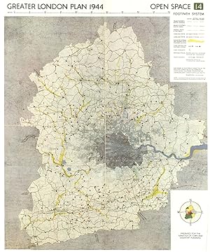
Condition: Good. GREATER LONDON PLAN. Open Space Footpath system. ABERCROMBIE 1944 old map. Vintage colour town planning map; Patrick Abercrombie (1944). 50.5 x 42.0cm, 19.75 x 16.5 inches; this is a folding map. Condition: Good. The image shown may have been taken from a different example of this map than that which is offered for sale. The map you will receive is in good condition but there may be minor variations in the condition from that shown in the image. There is nothing printed on the reverse side, which is plain.
-
![Seller image for Greater London plan 1944, by Patrick Abercrombie. A report prepared on behalf of the Standing conference on London regional planning by Professor Abercrombie at the request of the minister of town and country planning. (1945) [Leatherbound] for sale by S N Books World](https://pictures.abebooks.com/inventory/md/md30876975320.jpg)
LeatherBound. Condition: NEW. Leatherbound edition. Condition: New. Leather Binding on Spine and Corners with Golden leaf printing on spine. Bound in genuine leather with Satin ribbon page markers and Spine with raised gilt bands. A perfect gift for your loved ones. Reprinted from 1945 edition. NO changes have been made to the original text. This is NOT a retyped or an ocr'd reprint. Illustrations, Index, if any, are included in black and white. Each page is checked manually before printing. As this print on demand book is reprinted from a very old book, there could be some missing or flawed pages, but we always try to make the book as complete as possible. Fold-outs, if any, are not part of the book. If the original book was published in multiple volumes then this reprint is of only one volume, not the whole set. IF YOU WISH TO ORDER PARTICULAR VOLUME OR ALL THE VOLUMES YOU CAN CONTACT US. Resized as per current standards. Sewing binding for longer life, where the book block is actually sewn (smythe sewn/section sewn) with thread before binding which results in a more durable type of binding. Pages: 310 Language: English Pages: 310.
-
![Seller image for Greater London plan 1944, by Patrick Abercrombie. A report prepared on behalf of the Standing conference on London regional planning by Professor Abercrombie at the request of the minister of town and country planning. Volume 1944 (1945) [LeatherBound] for sale by S N Books World](https://pictures.abebooks.com/inventory/md/md30962385851.jpg)
LeatherBound. Condition: New. Leatherbound edition. Condition: New. Leather Binding on Spine and Corners with Golden leaf printing on spine. Bound in genuine leather with Satin ribbon page markers and Spine with raised gilt bands. A perfect gift for your loved ones. Reprinted from 1945 edition. NO changes have been made to the original text. This is NOT a retyped or an ocr'd reprint. Illustrations, Index, if any, are included in black and white. Each page is checked manually before printing. As this print on demand book is reprinted from a very old book, there could be some missing or flawed pages, but we always try to make the book as complete as possible. Fold-outs, if any, are not part of the book. If the original book was published in multiple volumes then this reprint is of only one volume, not the whole set. IF YOU WISH TO ORDER PARTICULAR VOLUME OR ALL THE VOLUMES YOU CAN CONTACT US. Resized as per current standards. Sewing binding for longer life, where the book block is actually sewn (smythe sewn/section sewn) with thread before binding which results in a more durable type of binding. Pages: 332 Language: English Volume 1944 Pages: 332 Volume 1944.
-
Condition: Good. LONDON. Proposed postwar development/new satellite towns. ABERCROMBIE 1944 map. Vintage colour town planning map; Patrick Abercrombie (1944). 50.0 x 43.0cm, 19.75 x 16.75 inches; this is a folding map. Condition: Good. The image shown may have been taken from a different example of this map than that which is offered for sale. The map you will receive is in good condition but there may be minor variations in the condition from that shown in the image. There is nothing printed on the reverse side, which is plain.
-

Condition: Good. This is an ex-library book and may have the usual library/used-book markings inside.This book has hardback covers. In good all round condition. No dust jacket. Please note the Image in this listing is a stock photo and may not match the covers of the actual item,1750grams, ISBN:
-
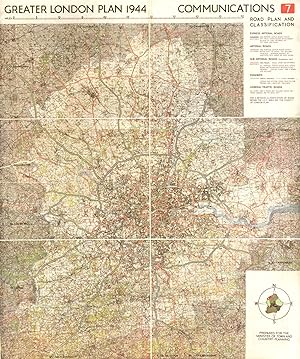
Condition: Good. GREATER LONDON PLAN. Motorways arterial ringways roads M25.ABERCROMBIE 1944 map. Vintage colour town planning map; Patrick Abercrombie (1944). 50.0 x 41.5cm, 19.5 x 16.25 inches; this is a folding map. Condition: Good. The image shown may have been taken from a different example of this map than that which is offered for sale. The map you will receive is in good condition but there may be minor variations in the condition from that shown in the image. There is nothing printed on the reverse side, which is plain.
-

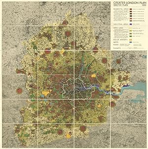
Condition: Acceptable. Most items will be dispatched the same or the next working day. An acceptable condition original edition. The spine cover has come completely loose from the binding. Some general fraying and dusty marks to the covers. The contents show a typical amount of tanning and handling but are in good condition overall, with a fair binding and unfaded text. Two good condition maps in colour are included in the pocket on the rear pastedown, With one titled 'Greater London Master Plan' that includes a key for residential areas, industrial areas, open land, major airports, water, roads and railways. Very good as a reading and reference copy only. A rare book and edition.
-

Condition: Acceptable. Most items will be dispatched the same or the next working day. An acceptable condition book. An advance limited edition copy of Professor Abercrombie's Outline Plan for Greater London, which was circulated for official purposes only to let the proposals be considered pending full publication. The paperback covers are dog-eared and have come loos from the binding, and the spine cover shows cracking and notable loss. The contents show a light amount of age and handling but also remain clean and well-bound, with only a few slacker sections towards the rear of the book. Includes one full-page map on the Greater London Plan's Four Rings, and a selection of black and white fold-out maps including one showing the proposed extension of existing built-up areas and sites for new satellite towns, a map of a road plan including Express arterial roads, Arterial roads, Sub-arterial roads and parkways. The final map shows railways with related proposals. A fair reading and reference copy of a limited and rare publication.
-
Greater London Plan 1944
Published by His Majesty's Stationery Office
Seller: Wonder Book, Frederick, MD, U.S.A.
Seller Rating:

Condition: Fair. London: His Majesty's Stationery Office, 1945. 4to. x,220pp. Illus., maps. Fair book. No dust jacket. Ex-library. Clean inside, binding good. (England, London, city planning) Inquire if you need further information. NOT AVAILABLE FOR SHIPMENT OUTSIDE OF THE UNITED STATES.
-
GREATER LONDON PLAN 1944; A Report prepared on Behalf of the Standing Conference on London Regional Planning by Professor Abercrombie at the Request of the Minister of Town and Country Planning
Published by HIS MAJESTY'S STATIONERY OFFICE, 1945
Hardcover. Condition: Very Good. HIS MAJESTY'S STATIONERY OFFICE 1945. Binding firm. Pages clean and bright. Fold out maps in very good condition. Inscribed by previous owner on flyleaf. ALL ITEMS ARE DISPATCHED FROM THE UK WITHIN 48 HOURS ( BOOKS ORDERED OVER THE WEEKEND DISPATCHED ON MONDAY) ALL OVERSEAS ORDERS SENT BY TRACKABLE AIR MAIL. IF YOU ARE LOCATED OUTSIDE THE UK PLEASE ASK US FOR A POSTAGE QUOTE FOR MULTI VOLUME SETS BEFORE ORDERING.
-
Greater London Plan 1944 A Report prepared on Behalf of the Standing Conference on London Regional Planning by Professor Abercrombie at the Request of the Minister of Town and Country Planning
Published by His Majesty;s Stationary Office, London, 1945
Seller: Old New York Book Shop, ABAA, Atlanta, GA, U.S.A.
Seller Rating:
First Edition
Hardcover. Condition: Good. First Edition. 221p quarto illus. with many foldouts. Also laid in is Outline Plan for Merseyside Number 20. Fraying at the spine heads, wearing at the corners, dust soiled. A good copy.
-
Greater London Plan 1944, A Report prepared on behalf of the Standing Conference on London Regional Planning by Professor Abercrombie at the Request of the Minister of Town and Country Planning
Published by His Majesty's Stationery Office, London, 1945
First Edition
Hardcover. Condition: Good. Dust Jacket Condition: No Dust Jacket. First Edition. Beige covers with gilt lettering and motif are darkened and are lightly worn at corners and spine-ends, sound binding, clean pages and end-papers. Large fold-out colour plans, some have a short tear in the gutter, colour single page plans, black and white single page plans, two folded colour master plans in wallet at rear. No dust-jacket. Quantity Available: 1. Shipped Weight: 2-3 kg. Pictures of this item not already displayed here available upon request. Inventory No: 53222091093. For International tracked shipping please select the Priority shipping service. This book is heavier than 1kg, and may incur additional delivery charges on some delivery services to some locations.
-
Condition: Good. GREATER LONDON MASTERPLAN. Population density. Wall map. ABERCROMBIE 1944. Vintage colour town planning wall map; Patrick Abercrombie (1944). 98.0 x 97.5cm, 38.5 x 38.25 inches; this is a folding map. Condition: Good. This map was originally printed as two separate pages which have been professionally joined to form a single sheet; The image shown may have been taken from a different example of this map than that which is offered for sale. The map you will receive is in good condition but there may be minor variations in the condition from that shown in the image. Please contact us if you would like to arrange to view this map. There are images and/or text printed on the reverse side of the picture. In some cases this may be visible on the picture itself or around the margin of the picture.
-
Greater London Plan 1944. A Report prepared on behalf of the Standing Conference on London Regional Planning by Professor Abercrombie at the request of the Minister of Town and Country Planning.
Published by London : Her Majesty`s Stationery Office,, 1945
Text auf Englisch. Gel�schter Bibl.-Stempel auf Titel. Die eingebundenen Pl�ne meist mit kleinem Randeinri�, ansonsten recht guter Zustand Sprache: Deutsch Gewicht in Gramm: 1550 X + 220 S. + 60 Tafeln mit farbigen und s/w Abbildungen + 10 farbige Ausfaltpl�nen + 2 farbige Ausfaltpl�ne als Beilage, weitere s/w Abbildungen im Text, 30 x 23 cm, fachm�nnisch nachgebundener Pappband.
-
Greater London Plan 1944. A Report prepared on behalf of the Standing Committee on London Regional Planning.at the request of the Minister of Town and Country Planning.
Published by London, His Majesty's Stationery Office, 1945
Seller: antiquariat peter petrej - Bibliopolium AG, Z�rich, ZH, Switzerland
Association Member: ILAB VEBUKU
Seller Rating:

4�, 219 S., 89 Abb., 33 Illustrationen, 11 Faltkarten., 2 lose Karten beiliegend., OLwd., Deckel beschienen beschienen, Exlibris a. Vors., min angeschmutzt, sonst sauber. "Following World War II, London was presented with an opportunity to amend the perceived failings of unplanned and haphazard development that had occurred as a result of rapid industrialization in the nineteenth century. During the Second World War, the blitz had destroyed large urban areas throughout the entire county of London, but particularly the central core. Over 50,000 inner London homes were completely destroyed, while more than 2 million dwellings experienced some form of bomb damage. This presented the London City Council with a unique chance to plan and rebuild vacant tracts of the city on a scale not seen since the Great Fire of London. Although the report was comprehensive in attempting to solve the issues facing London at the time, its implementation was not fully realized. The economic climate in Britain during the post war era simply did not allow for major infrastructure development on the scale that Abercrombie had suggested." Text engl. 2100 gr. Schlagworte: Architektur - St�dtebau.
-
GREATER LONDON PLAN 1944. A Report Prepared on Behalf of Standing Conference on London Regional Planning By Professor Abercrombie at the Request of the Minister of Town and Country Planning
Published by HM Stationary Office, London, 1945
Seller: M.POLLAK ANTIQUARIAT Est.1899, ABA, ILAB, Tel-Aviv, Israel
Seller Rating:
Original Cloth. Condition: Good. X+221pp. PROFUSELY ILLUSTRATED WITH PLANS AND MAPS ( MANY FOLDING) Spine expertly repaired, Minimal foxing on the outside, first and very last page. Light outside wear. Two 5mm holes on upper left corner of title page. OTHERWISE A VERY GOOD AND CLEAN COPY.
-
Hardcover. Condition: As New. 1st Edition. This rare copy is in as new, unmarked condition bound in tan cloth covered boards with bright gilt titling to the spine and the upper board. This copy is bright, tight, white and square. A dust wrapper is not called for. International postal rates are calculated on a book weighing 1 Kilo, in cases where the book weighs more than 1 Kilo increased postal rates will be quoted, where the book weighs less then postage will be reduced accordingly. Through the latter part of WW2 Professor Abercrombie and his team worked on this great master plan for London. It was prepared on behalf of the Standing Conference on London Regional Planning at the request of the Minister of Town and Country Planning. They hoped not simply to repair the bombed capital but to make the city a very much better place for everyone who lived or worked or travelled through it. Complete with large fold out maps bound in and two coloured maps to a wallet on the rear paste down. Ref CCC 1.
-
GREATER LONDON PLAN 1944
Published by His Majesty's Stationery Office, London, 1944
Seller: Second Story Books, ABAA, Rockville, MD, U.S.A.
Seller Rating:
First Edition
Hardcover. First Edition. Quarto 221 pages, VG/G+; spine is beige with black lettering; dust jacket is in a mylar covering, has moderate wear along the top and bottom edges, with chipping at the top and bottom of the spine, has several small closed and open tears, has several pieces of tape on the inside, has rubbing and discoloration throughout; binding has minor wear along the top and bottom edges, has heavy bumping on the fore edge corners, boards have minor warping; pages have minor age toning and warping; profusely illustrated with maps and photographs; contains a two part separate map of the master plan; shelved case 9. After the German aerial invasion of Britain in World War II, so much of London had been destroyed that the British government organized and commissioned a large scale plan to rebuild and restructure the city. This was the largest rebuilding London had experienced since the Great Fire of 1666. 1317311. Shelved Dupont Bookstore.
-
GREATER LONDON PLAN 1944 - Illustrated with 89 Photographs, 34 Drawings & Diagrams (Some in Colour) & Master Plan
Published by His Majesty's Stationery Office, 1945
First Edition
Hardcover. Condition: Very Good. Dust Jacket Condition: Fair. First Edition. His Majesty's Stationery Office 1945. Binding firm. Pages clean and bright, no markings. Unclipped Dust Jacket, with big tears and chips. includs maps in very good condition. ALL ITEMS ARE DISPATCHED FROM THE UK WITHIN 48 HOURS ( BOOKS ORDERED OVER THE WEEKEND DISPATCHED ON MONDAY) ALL OVERSEAS ORDERS SENT BY TRACKABLE AIR MAIL. IF YOU ARE LOCATED OUTSIDE THE UK PLEASE ASK US FOR A POSTAGE QUOTE FOR MULTI VOLUME SETS BEFORE ORDERING.
-
Greater London plan 1944
Published by His Majesty's Stationery Office, London, 1945
Seller: Rulon-Miller Books (ABAA / ILAB), St. Paul, MN, U.S.A.
Association Member: ABAA ILAB RMABA
Seller Rating:
First Edition
First edition, 4to, pp. x, 220, [1]; 'A Report prepared on behalf of the Standing Conference on London Regional Planning by Professor Abercrombie at the request of the Minister of Town and Country Planning'; with 89 photographic illustrations, 34 drawings, diagrams, maps (some in color, folding), large folding master plan (in 2 parts) inserted at rear pocket; noted city planner Weiming Lu's bookplate on front free pastedown, minor toning, extremities a bit worn, else very good in original beige cloth lettered in gilt on upper cover and spine, in a rather chipped and toned dust jacket lettered in black.
-

Greater London plan 1944 / by Patrick Abercrombie . A report prepared on behalf of the Standing Conference on London Regional Planning by Professor Abercrombie at the request of the Minister of Town and Country Planning.
Published by London : H.M. Stationery Off., 1945
First Edition
First Edition. Near fine gilt-blocked cloth copy with rare dust-wrapper in very good, slightly edge-nicked and dust-toned condition, now mylar-sleeved. Remains particularly well-preserved overall; tight, bright, clean and strong. Physical description; x, 220, [1] pages illustrations, tables, plates (some color), maps (some folded), plans (some color, some folded), diagrams ; 33 cm. Notes; Two colored folded plans in pocket. A continuation of County of London plan, prepared for the London County Council by J.H. Forshaw and Patrick Abercrombie, 1943. cf. p. 1. Includes bibliographical references. Contents; 1. Population: distribution and change 1921-1938 -- 2. Communities: sporadic growth of communities from 1918 to 1939 -- 3. Communities: housing built by private enterprise & local authorities between 1918 & 1939 -- 4. Communities: built-up areas and open land in 1939 -- 5. Communities: proposed extension of existing built-up areas and sites for new satellite towns -- 6. Industry: analytical survey of industrial areas -- 7. Communications: road plan and classification --8. Communications: Roads - Greater London traffic densities, England & Wales traffic densities, railways existing routes with industries & markets, airways fast land routes to airports & satellites (4 maps on 2 sheets) -- 10. Open space: open space system -- 14. Open space: footpath system. Subjects; City planning England London. Regional planning England London. Land use England. Cities and towns Planning London. Human Settlements. 1 Kg.
-
Greater London Plan 1944 - A Report Prepared on Behalf of the Standing Conference on London Regional Planning by Professor Abercrombie At the Request of the Minister of Town and Country Planning
Published by His Majesty's Stationery Office, London, 1945
First Edition
HARDCOVER. 1st Edition. 1st printing. Large heavy 4to. in tan cloth, gilt lettering to spine and front cover, 220pp, index, 10 very large (4 and 6 panel) folding mainly colour printed maps, full page colour and line maps, 27pp b/w photos, 2 very large folded colour printed maps at rear - one North London, the other of central and South London (in total about 110cm x 110cm). This copy collated complete. Through the latter part of WW2 Abercrombie and his team worked on this great master plan for London. They hoped not simply to repair the bombed capital but to make it very much better for everyone who lived or worked in it. With hindsight the proposals were a mixed bag, only a few were substantially realised, but together they were an important work of great optimism that played a small but significant part in the post-war British zeitgeist CONDITION: Covers very slightly sunned, pages a little tanned else a near FINE very clean and tight unmarked copy with no significant faults (two of the folding maps have a near invisible repaired tear where the inner margin is bound into the book). It lacks the dustwrapper but is an uncommonly nice copy ] __NOTE Due to size and/or weight, shipping will cost more than price shown above. Orders made by card will be completed only after you have approved any such extra cost._ __To see more of our books on Architecture, Planning etc. type DbbARCH in the Keywords search box._We Ship in PROTECTIVE CARD PARCELS.
-

Greater London plan 1944 / by Patrick Abercrombie . A report prepared on behalf of the Standing Conference on London Regional Planning by Professor Abercrombie at the request of the Minister of Town and Country Planning.
Published by London : H.M. Stationery Off., 1945
First Edition
First Edition. Near fine gilt-blocked cloth copy with rare dust-wrapper in very good, slightly edge-nicked and dust-toned condition, now mylar-sleeved. Remains particularly well-preserved overall; tight, bright, clean and strong. Physical description; x, 220, [1] pages illustrations, tables, plates (some color), maps (some folded), plans (some color, some folded), diagrams ; 33 cm. Notes; Two colored folded plans in pocket. A continuation of County of London plan, prepared for the London County Council by J.H. Forshaw and Patrick Abercrombie, 1943. cf. p. 1. Includes bibliographical references. Contents; 1. Population: distribution and change 1921-1938 -- 2. Communities: sporadic growth of communities from 1918 to 1939 -- 3. Communities: housing built by private enterprise & local authorities between 1918 & 1939 -- 4. Communities: built-up areas and open land in 1939 -- 5. Communities: proposed extension of existing built-up areas and sites for new satellite towns -- 6. Industry: analytical survey of industrial areas -- 7. Communications: road plan and classification --8. Communications: Roads - Greater London traffic densities, England & Wales traffic densities, railways existing routes with industries & markets, airways fast land routes to airports & satellites (4 maps on 2 sheets) -- 10. Open space: open space system -- 14. Open space: footpath system. Subjects; City planning England London. Regional planning England London. Land use England. Cities and towns Planning London. Human Settlements. 1 Kg.
-
Greater London Plan 1944. A Report prepared on behalf of the Standing Committee on London Regional Planning.at the request of the Minister of Town and Country Planning.
Publication Date: 1945
Seller: Ursus Rare Books, New York, NY, U.S.A.
Seller Rating:
ABERCROMBIE, Patrick. Greater London Plan 1944. A Report prepared on behalf of the Standing Committee on London Regional Planning at the Request of the Minister of Town and Country Planning. X, 220, [1] pp. Illustrated with 89 photographs & 33 illustrations from drawings, diagrams, & maps (some in colour, 9 folding) plus a large folding master plan in 2 sheets inserted in envelope at rear. Folio, bound in publisher's cloth and dustwrapper. London: His Majesty's Stationery Office, 1945. "Following World War II, London was presented with an opportunity to amend the perceived failings of unplanned and haphazard development that had occurred as a result of rapid industrialization in the nineteenth century. During the Second World War, the blitz had destroyed large urban areas throughout the entire county of London, but particularly the central core. Over 50,000 inner London homes were completely destroyed, while more than 2 million dwellings experienced some form of bomb damage. This presented the London City Council with a unique chance to plan and rebuild vacant tracts of the city on a scale not seen since the Great Fire of London. Although the report was comprehensive in attempting to solve the issues facing London at the time, its implementation was not fully realized. The economic climate in Britain during the post war era simply did not allow for major infrastructure development on the scale that Abercrombie had suggested." Dust jacket worn, else fine.