
Order Total (1 Item Items):
Shipping Destination:

England Wales Channel Islands Parts by Reynolds James (1 results)
Feedback
Skip to main search results
Search filters
Product Type
- All Product Types
- Books (No further results match this refinement)
- Magazines & Periodicals (No further results match this refinement)
- Comics (No further results match this refinement)
- Sheet Music (No further results match this refinement)
- Art, Prints & Posters (No further results match this refinement)
- Photographs (No further results match this refinement)
- Maps (1)
- Manuscripts & Paper Collectibles (No further results match this refinement)
Condition
- All Conditions
- New (No further results match this refinement)
- Used (1)
Binding
- All Bindings
- Hardcover (No further results match this refinement)
- Softcover (No further results match this refinement)
Collectible Attributes
- First Edition (No further results match this refinement)
- Signed (No further results match this refinement)
- Dust Jacket (No further results match this refinement)
- Seller-Supplied Images (1)
- Not Print on Demand (1)
Free Shipping
- Free Shipping to United Kingdom (No further results match this refinement)
Seller Rating
-
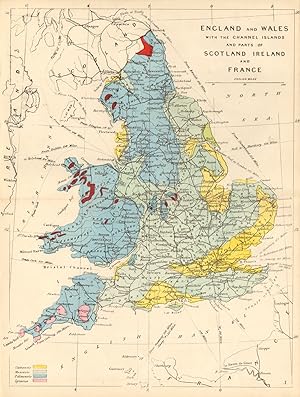
England & Wales with the channel Islands and parts of Scotland Ireland & France
Publication Date: 1864
Map
Condition: Good. ENGLAND & WALES antique geological map by James Reynolds 1864. Antique hand-coloured geological map; James Reynolds (1864). 23.5 x 18.0cm, 9.25 x 7 inches; this is a folding map. Condition: Good. The image shown may have been taken from a different example of this map than that which is offered for sale. The map you will receive is in good condition but there may be minor variations in the condition from that shown in the image. There is nothing printed on the reverse side, which is plain.