Order Total (1 Item Items):
Shipping Destination:

American Color Map 1853 Statistics (1 results)
Skip to main search results
Product Type
- All Product Types
- Books
- Magazines & Periodicals
- Comics
- Sheet Music
- Art, Prints & Posters
- Photographs
- Maps (1)
- Manuscripts & Paper Collectibles
Condition
Binding
- All Bindings
- Hardcover
- Softcover
Collectible Attributes
- First Edition (1)
- Signed
- Dust Jacket
- Seller-Supplied Images (1)
- Not Print on Demand (1)
Free Shipping
- Free US Shipping
Seller Location
Seller Rating
-
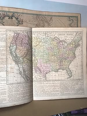
American Color Map 1853 with Statistics of United States 1850
Published by Thomas Cowperthwait & Co (Philadelphia) at 253 Market St. Philadelphia, 1853
Map First Edition
No Binding. Condition: Near Fine. No Jacket. 1st Edition. This authentic vintage map of US with hand coloring. As a bonus, the map comes with statistics of the US for 1850, including the number of slaves in 1850. The verso small wood-cut engravings and the maps of Maine, New Hampshire and Vermont. The map should be made before 1853 because The Oregon State was divided into Washington and Oregon in 1853. Size of the US map (1853): W 33cm x H 22 cm (without the margin) Size of the maps of Maine, New Hampshire and Vermont: 21 cm x 21 cm. A few foxing spots. Overall very good condition.