Order Total (1 Item Items):
Shipping Destination:

1975 1977 by Great Britain (2 results)
Skip to main search results
Product Type
- All Product Types
- Books (2)
- Magazines & Periodicals
- Comics
- Sheet Music
- Art, Prints & Posters
- Photographs
- Maps
-
Manuscripts &
Paper Collectibles
Condition
- All Conditions
- New
- Used
Binding
Collectible Attributes
- First Edition
- Signed
- Dust Jacket (1)
- Seller-Supplied Images (1)
- Not Printed On Demand
Seller Location
Seller Rating
-

Labour Force Survey: 1975 & 1977 (Series LFS)
Published by The Stationery Office Books, 1980
ISBN 10: 0116907363ISBN 13: 9780116907363
Book
Condition: Good. Your purchase helps support Sri Lankan Children's Charity 'The Rainbow Centre'. Ex-library, so some stamps and wear, and may have sticker on cover, but in good overall condition. Our donations to The Rainbow Centre have helped provide an education and a safe haven to hundreds of children who live in appalling conditions.
-
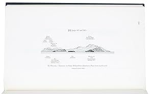
South Indian Ocean pilot. Madagascar, �les Comores, �le de la R�union, Mauritius, Seychelles Group, Chagos Archipelago, and other islands lying westward of Longitude 80� East. Eighth edition.Taunton, published by the hydrographer of the navy, 1971. With supplement no. 5 (1977). 8vo. With 2 small maps, 8 coastal profiles, 9 diagrams and 11 climatic tables in the book and also 1 view of the coast of Marie Louise Islet (1975) in the supplement.Contemporary blue cloth with printed title in yellow.
Seller: Antiquariaat FORUM BV, Houten, Netherlands
Seller Rating:

XI, [1 blank], 333, [1]; 40 pp.Eighth edition (1971) with supplement no. 5 (1977) of the standard pilot guide for the South Indian Ocean published by the British admiralty. It provides the latest admiralty sailing directions and information for sailing in the ocean and along and around the coasts of Madagascar and the east coasts of Africa.The book starts with a foreword by G.P.D. Hall, rear-admiral and hydrographer of the navy. It has 11 chapters. The first chapter includes general information about the South Indian Ocean and vicinity, such as details on the islands governments, climate, dependencies, flora, fauna, populations, trade, products, shipping, currency, weights, measures, time and health. The other chapters give detailed navigation details (directions, latitudes and longitudes, shoals, tides, widths, anchorage, dangers) for, as the title says, "Madagascar, �les Comores, �le de la R�union, Mauritius, Seychelles Group, Chagos Archipelago" and other islands lying westward of 80� East longitude. In the first six chapters in particular the route to Madagascar is described. The other chapters describe the routes to other islands, such as Mauritius, Agalega Island or the Saya de Malha bank. The book ends with a list of publications of the Hydrographic Department.This book, very thorough and detailed, must have been a useful compendium for pilots, because it gives more than just textual information: it contains 8 coastal profiles, namely from the coasts of Madagascar and the east coasts of Africa, 9 diagrams with the predominant currents in the South Indian Ocean and also 11 climatic tables concerning the air temperature, humidity, rain, wind directions and wind speed around the different islands, measured over different periods. The book also has two small maps with red frames and a chapter signing that show which area is described in each chapter. One map depicts the South Indian Ocean, the other primarily one part of Madagascar. The supplement contains a revised version of these maps, as well as what appears to be a photograph from 1975 showing the coast of Marie Louise Islet. The foreword in the supplement is written by another rear-admiral: D.W. Haslam.In very good condition.