Order Total (1 Item Items):
Shipping Destination:

Swanston George (75 results)
Skip to main search results
Product Type
- All Product Types
- Books (19)
- Magazines & Periodicals
- Comics
- Sheet Music
- Art, Prints & Posters (1)
- Photographs
- Maps (55)
- Manuscripts & Paper Collectibles
Condition
Binding
- All Bindings
- Hardcover
- Softcover (8)
Collectible Attributes
- First Edition
- Signed
- Dust Jacket
- Seller-Supplied Images (68)
- Not Print on Demand (71)
Free Shipping
- Free US Shipping
Seller Location
Seller Rating
-
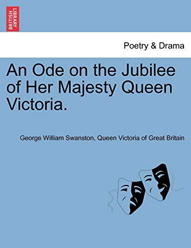
An Ode on the Jubilee of Her Majesty Queen Victoria.
Published by British Library, Historical Print Editions, 2011
ISBN 10: 1241150729ISBN 13: 9781241150723
Book
Condition: New.
-
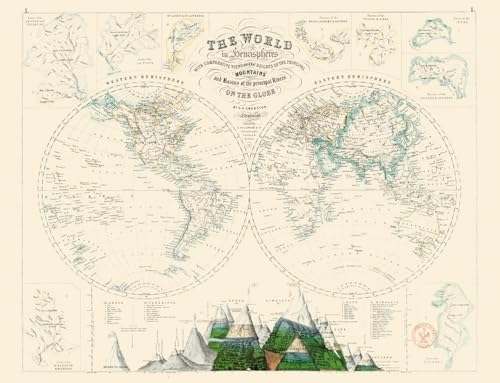
Carte Le monde en h�misph�res
Published by Reliefs, 2024
ISBN 10: 2380361304ISBN 13: 9782380361308
Book
Condition: Neuf.
More buying choices from other sellers on AbeBooks
New offers from � 15.76
Used offers from � 28.14
Also find Softcover
-
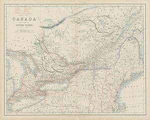
Condition: Good. Canada with part of United States. West. Ontario & Quebec. SWANSTON 1860 map. Antique atlas map with original hand colour; Engraved at Stanford's Geographical Establishment (1860). 44.0 x 55.0cm, 17.25 x 21.75 inches; this is a folding map. Condition: Good. There is nothing printed on the reverse side, which is plain.
-
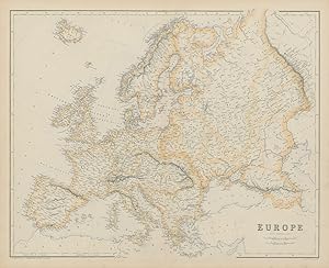
Condition: Good. Europe by G.H. SWANSTON 1860 old antique vintage map plan chart. Antique atlas map with original hand colour; G H Swanston (1860). 44.0 x 54.5cm, 17.5 x 21.5 inches; this is a folding map. Condition: Good. There is nothing printed on the reverse side, which is plain.
-
Condition: Good. France & principal foreign possessions. Guadaloupe Martinique. SWANSTON 1860 map. Antique atlas map with original hand colour; G H Swanston (1860). 44.5 x 54.0cm, 17.5 x 21.25 inches; this is a folding map. Condition: Good. There is nothing printed on the reverse side, which is plain.
-
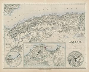
Algeria // Oran and Environs // Algiers and Environs // Constantine and Environs
Publication Date: 1860
Map
Condition: Good. Algeria. Environs of Oran, Algiers & Constantine. SWANSTON 1860 old map. Antique atlas map with original hand colour; Drawn by J Hugh Johnson/Engraved at Stanford's Geographical Establishment (1860). 43.5 x 54.0cm, 17.25 x 21.25 inches; this is a folding map. Condition: Good. There is nothing printed on the reverse side, which is plain.
-

Condition: Fair. Europe by G.H. SWANSTON 1860 old antique vintage map plan chart. Antique atlas map with original hand colour; G H Swanston (1860). 44.0 x 54.5cm, 17.5 x 21.5 inches; this is a folding map. Condition: Fair: Light soiling. There is nothing printed on the reverse side, which is plain.
-
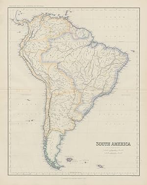
Condition: Good. South America by George Heriot SWANSTON 1860 old antique map plan chart. Antique atlas map with original hand colour; G H Swanston (1860). 53.0 x 42.5cm, 21 x 16.75 inches; this is a folding map. Condition: Good. Light spotting. There is nothing printed on the reverse side, which is plain.
-
Condition: Good. Holland and Belgium. Luxembourg. Benelux. SWANSTON 1860 old antique map chart. Antique atlas map with original hand colour; G H Swanston (1860). 54.0 x 44.0cm, 21.25 x 17.25 inches; this is a folding map. Condition: Good. There is nothing printed on the reverse side, which is plain.
-
Condition: Good. Sweden and Norway with Russian Finland. Scandinavia. SWANSTON 1860 old map. Antique atlas map with original hand colour; G H Swanston (1860). 53.5 x 43.0cm, 21 x 17 inches; this is a folding map. Condition: Good. There is nothing printed on the reverse side, which is plain.
-
Condition: Good. Spain and Portugal by George Heriot SWANSTON. Iberia 1860 old antique map. Antique atlas map with original hand colour; G H Swanston (1860). 44.0 x 54.5cm, 17.25 x 21.5 inches; this is a folding map. Condition: Good. There is nothing printed on the reverse side, which is plain.
-
Condition: Good. States of the Germanic Confederation. Germany Austria Czechia. SWANSTON 1860 map. Antique atlas map with original hand colour; J Hugh Johnson (1860). 56.0 x 44.0cm, 22 x 17.25 inches; this is a folding map. Condition: Good. There is nothing printed on the reverse side, which is plain.
-
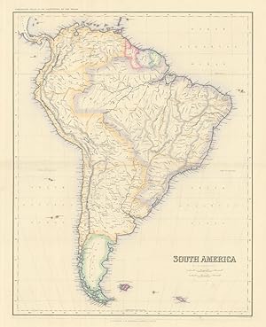
Condition: Good. South America by George Heriot SWANSTON 1860 old antique map plan chart. Antique atlas map with original hand colour; G H Swanston (1860). 53.0 x 42.5cm, 21 x 16.75 inches; this is a folding map. Condition: Good. There is nothing printed on the reverse side, which is plain.
-
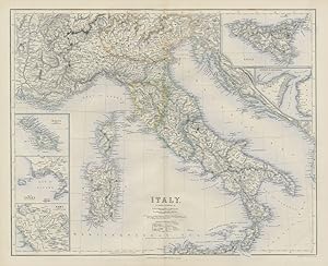
Condition: Good. Italy with Savoy/Savoie. Malta Naples Rome Strait of Messina. SWANSTON 1860 map. Antique atlas map with original hand colour; G H Swanston (1860). 44.0 x 54.0cm, 17.25 x 21.25 inches; this is a folding map. Condition: Good. There is nothing printed on the reverse side, which is plain.
-
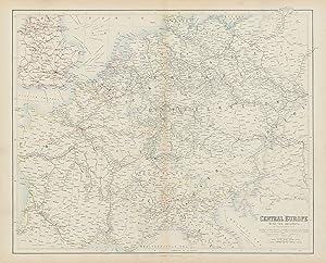
Condition: Good. Central Europe with Railways: operating & under construction. SWANSTON 1860 map. Antique atlas map with original hand colour; J Bartholomew (1860). 44.5 x 55.0cm, 17.5 x 21.75 inches; this is a folding map. Condition: Good. There is nothing printed on the reverse side, which is plain.
-
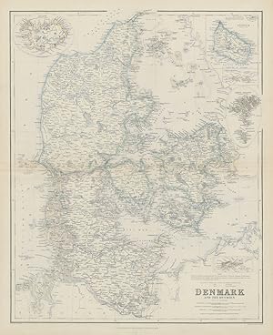
Condition: Good. Denmark & the Duchies. St Croix Iceland Bornholm Faeroes. SWANSTON 1860 map. Antique atlas map with original hand colour; G H Swanston (1860). 53.5 x 43.5cm, 21 x 17.25 inches; this is a folding map. Condition: Good. There is nothing printed on the reverse side, which is plain.
-
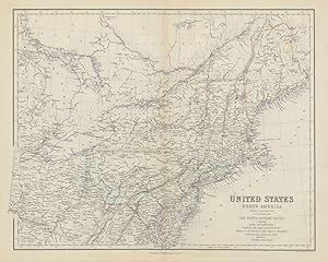
Condition: Good. United States North East. Mid-Atlantic & New England states. SWANSTON 1860 map. Antique atlas map with original hand colour; G H Swanston (1860). 43.0 x 54.0cm, 17 x 21.25 inches; this is a folding map. Condition: Good. There is nothing printed on the reverse side, which is plain.
-

Condition: Good. Russia in Europe. Ukraine Caucasus Finland Poland Baltics. SWANSTON 1860 map. Antique atlas map with original hand colour; G H Swanston (1860). 56.5 x 43.0cm, 22.25 x 17 inches; this is a folding map. Condition: Good. There is nothing printed on the reverse side, which is plain.
-
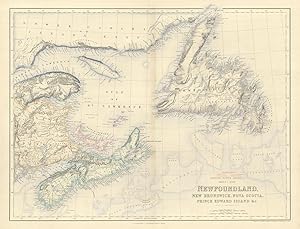
British North America sheet 1, East. Newfoundland, New Brunswick, Nova Scotia, Prince Edward Island &c.
Publication Date: 1860
Map
Condition: Good. Newfoundland New Brunswick Nova Scotia PEI. Canada Maritimes. SWANSTON 1860 map. Antique atlas map with original hand colour; Engraved at Stanford's Geographical Establishment (1860). 43.5 x 55.5cm, 17 x 21.75 inches; this is a folding map. Condition: Good. There is nothing printed on the reverse side, which is plain.
-
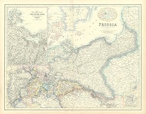
Prussia // The Lower Course & Estuary of The River Oder with the Island of Rugen &c.
Publication Date: 1860
Map
Condition: Good. Prussia. Oder estuary & Rugen. Eastern Germany & Poland. SWANSTON 1860 old map. Antique atlas map with original hand colour; J Hugh Johnson (1860). 44.0 x 56.0cm, 17.25 x 22 inches; this is a folding map. Condition: Good. There is nothing printed on the reverse side, which is plain.
-
Condition: Fair. Turkish Empire. Turkey Balkans Levant. Dardanelles & Bosphorus SWANSTON 1860 map. Antique atlas map with original hand colour; unknown (1860). 44.5 x 55.0cm, 17.5 x 21.75 inches; this is a folding map. Condition: Fair: Tide marks in margins. Creasing across top right corner. There is nothing printed on the reverse side, which is plain.
-
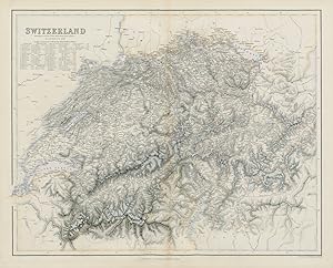
Condition: Good. Switzerland with table of 40 highest alpine peaks. SWANSTON 1860 old map. Antique atlas map with original hand colour; G H Swanston (1860). 43.5 x 54.0cm, 17 x 21.25 inches; this is a folding map. Condition: Good. There is nothing printed on the reverse side, which is plain.
-
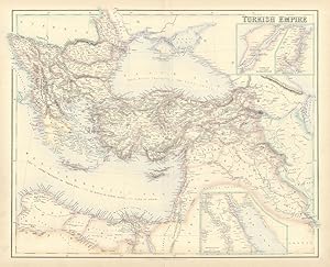
Condition: Good. Turkish Empire. Turkey Balkans Levant. Dardanelles & Bosphorus SWANSTON 1860 map. Antique atlas map with original hand colour; unknown (1860). 44.5 x 55.0cm, 17.5 x 21.75 inches; this is a folding map. Condition: Good. There is nothing printed on the reverse side, which is plain.
-

Condition: Good. Switzerland with table of 40 highest alpine peaks. SWANSTON 1860 old map. Antique atlas map with original hand colour; G H Swanston (1860). 43.5 x 54.0cm, 17 x 21.25 inches; this is a folding map. Condition: Good. There is nothing printed on the reverse side, which is plain.
-
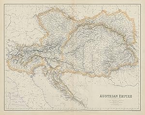
Condition: Good. Austrian Empire. Hungary Czechia Croatia Lombardy Veneto. SWANSTON 1860 map. Antique atlas map with original hand colour; G H Swanston (1860). 43.5 x 54.5cm, 17 x 21.5 inches; this is a folding map. Condition: Good. There is nothing printed on the reverse side, which is plain.
-
Condition: Good. Russian Empire according to Kiepert. Siberia & Central Asia. SWANSTON 1860 map. Antique atlas map with original hand colour; G H Swanston (1860). 44.0 x 54.0cm, 17.25 x 21.25 inches; this is a folding map. Condition: Good. There is nothing printed on the reverse side, which is plain.
-
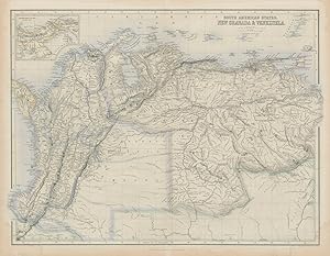
Condition: Good. South America. New Granada & Venezuela. Colombia Panama. SWANSTON 1860 old map. Antique atlas map with original hand colour; Engraved by J Bartholomew (1860). 43.5 x 56.0cm, 17 x 22 inches; this is a folding map. Condition: Good. Tide marks in margins. There is nothing printed on the reverse side, which is plain.
-
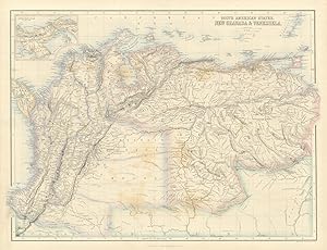
Condition: Fair. South America. New Granada & Venezuela. Colombia Panama. SWANSTON 1860 old map. Antique atlas map with original hand colour; Engraved by J Bartholomew (1860). 43.5 x 56.0cm, 17 x 22 inches; this is a folding map. Condition: Fair: Toning. There is nothing printed on the reverse side, which is plain.
-
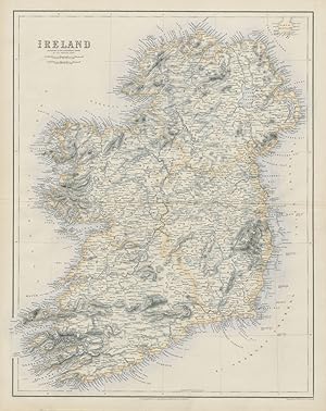
Condition: Good. Ireland by George Heriot SWANSTON 1860 old antique vintage map plan chart. Antique atlas map with original hand colour; G H Swanston (1860). 55.5 x 44.0cm, 21.75 x 17.25 inches; this is a folding map. Condition: Good. There is nothing printed on the reverse side, which is plain.
-
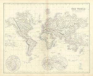
Condition: Fair. The World on Mercator's Projection. SWANSTON 1860 old antique map plan chart. Antique atlas map with original hand colour; G H Swanston (1860). 44.0 x 53.5cm, 17.25 x 21 inches; this is a folding map. Condition: Fair: Light soiling. There is nothing printed on the reverse side, which is plain.