Order Total (1 Item Items):
Shipping Destination:

Piri Reis (22 results)
Product Type
- All Product Types
- Books (22)
- Magazines & Periodicals
- Comics
- Sheet Music
- Art, Prints & Posters
- Photographs
- Maps
- Manuscripts & Paper Collectibles
Condition
Binding
Collectible Attributes
- First Edition
- Signed
- Dust Jacket
- Seller-Supplied Images (7)
- Not Print on Demand (22)
Free Shipping
- Free US Shipping
Seller Location
Seller Rating
-

Piri Reis haritasi = La carta marina di Piri Reis = Dei Karte des Piri Reis = Carte de Piri Reis = Piri Reis map.
Published by Istanbul: Deniz Muzesi Komutanligi, c. 2000., Istanbul:, 2000
Book
Soft cover. Condition: New. PIRI REIS Piri Reis haritasi = La carta marina di Piri Reis = Dei Karte des Piri Reis = Carte de Piri Reis = Piri Reis map. Istanbul: Deniz Muzesi Komutanligi, c. 2000. 8vo., [2], iii, 44 p., 1 folding map. In Turkish, Italian, German, French and English. Paperback. New ISBN: CATALOG: Maps & Engravings KEYWORDS: Piri Reis Map Geography Navigation.
-
Piri Reis haritasi = La carta marina di Piri Reis = Dei Karte des Piri Reis = Carte de Piri Reis = Piri Reis map.
Published by Istanbul: Deniz Kuvvetleri Komutanligi Hidrografi Nesriyati, 1966., Istanbul:, 1966
Book
Soft cover. Condition: Very Good. PIRI REIS Piri Reis haritasi = La carta marina di Piri Reis = Dei Karte des Piri Reis = Carte de Piri Reis = Piri Reis map. Istanbul: Deniz Kuvvetleri Komutanligi Hidrografi Nesriyati, 1966. 2nd ed., 4to., [1], ii, 31 p., 1 fold. b/w map, , 1 fold. color map. In Turkish, Italian, German, French and English. Paperback. Very good ISBN: CATALOG: Maps & Engravings KEYWORDS: Piri Reis Map Geography Navigation.
-
Proceedings of the International Piri Reis Symposium.= Uluslararasi Piri Reis Sempozyumu Tebligler kitabi. 27-29 September 2004.
Published by Seyir, Hidrografi, Osinografi Daire Baskanligi, Istanbul, 2004
Seller: Khalkedon Rare Books, IOBA, Istanbul, Turkey
Seller Rating:

Book
Hardcover. Condition: New. Original bdg. HC. 4to. (31 x 21 cm). In English and Turkish. [xv], 84, 53, 41, 64, 54, 131, 12, 32, [7] p., color ills. Symposium contains 8 sessions and pages numbered session by session. Proceedings of the International Piri Reis Symposium.= Uluslararasi Piri Reis Sempozyumu Tebligler kitabi. 27-29 September 2004.
-
KITAB-I BAHRIYE [VOLUME 1 ONLY]
Published by Historical Research Foundation, İstanbul Research Center, Istanbul, 1988
ISBN 10: 975170281XISBN 13: 9789751702814
Seller: Second Story Books, ABAA, Rockville, MD, U.S.A.
Seller Rating:

Book
Hardcover. Quarto; Volume 1 [of 4] only; G; Hardcover; Spine, grey with black print; Boards in grey cloth with black and gold print, slight wear to spine caps and corners, else clean and strong; Text block with black ribbon marker, spotting to edges and endpapers, inscription in ink on half-title page, else clean and tight; "Ministry of Culture and Tourism of the Turkish Republic, Ankara"- at head to title; "Facsimile reproductions of the original Bahriye together with its text transcribed in the modern Turkish alphabet and then rendered into modern Turkish and English"- p. 24; 455 pages, illustrated (color). [Oversized book(s). Additional postage necessary for expedited/international orders. Economy International shipping unavailable due to weight restrictions. For international/expedited customers, please inquire for rates] NOTE: Shelved in Room X, Case #3-4. 1359583. FP New Rockville Stock.
-
Kitab-i bahriye. Hacim I. Vol. 1. Ed. by Ertugrul Zekai �kte.
Published by Istanbul, The Historical Research Foundation 1988., 1988
4�. 451 S. m. 212 Faksimiles u. 7 Karten. Ill. Ppbd. (Text in lat. und arab. Schrift). Auf T�rkisch u. Englisch.
-
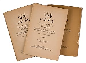
Das t�rkische Segelhandbuch f�r das Mittell�ndische Meer vom Jahre 1521. Hrsg. von Paul Kahle. Band I, Lieferung 2, Kapitel 29-60.
Published by Berlin, W. de Gruyter, 1927
Book
Kartonierter Originaleinband. Condition: Sehr gut. No. 65-137 einseitig bedruckte faksimilierte Tafeln. *Band I enth�lt das Faksimile des Originaltextes in 60 Kapiteln in t�rkischem Text mit Abbildungen - hiervon ist nur der zweite Teil (kapitel 29-60) mit den Tafeln 65-137 vorhanden. Von Band II (�bersetzung) erschien nur eine erste Lieferung (siehe Verlag-Kat. de Gruyter 1950, S. 216), die hier nicht vorhanden ist. Sprache: Deutsch Gewicht in Gramm: 1000.
-

P�r� Reis - The Book of Bahriye
Published by Boyut Yayin Grubu, 2013
ISBN 10: 9752310516ISBN 13: 9789752310513
Book
Condition: Good. Book is in Used-Good condition. Pages and cover are clean and intact. Used items may not include supplementary materials such as CDs or access codes. May show signs of minor shelf wear and contain limited notes and highlighting. 2.65.
-
Istanbul, The Historical Research Foundation, 1988.
-
4�. LV, 855, 6, 72 Pages. Original Cloth-Volume (gilt Lettering on the Spine). Inside very good Condition. No Markings in the Text! No Underlinings! No Owner's Note! Half of the Spine is harder rubbed. The Volume otherwise slightly rubbed and slightly bumped. T�rk tarihi arastirma kurumu yayinlarindan, 2.
-

P�r� Reis - Kitab-i Bahriye (= Book of Navigation) Book 1 & 2
Published by The Historical Research Foundation/Ministry of Culture and Tourism of the Turkish Republic, Ankara, 1988
Hardcover, 30 cm, 903 pp. Ills.: color illustrations. Piri Reis (1465/70-1553) was an Ottoman admiral, geographer and cartographer. His Book of Navigation gives detailed information on navigation and accurate charts describing the important ports and cities of the Mediterranean Sea. One of the most famous cartographical works of the sixteenth century. Cond.: goed / good. Text in Turkish and English. Lots of maps.
-
Kitab-i Bahriye.
Published by Turk Tarih Kurumu Yayinlari, 1935
Seller: Librakons Rare Books and Collectibles, Istanbul, Turkey
Association Member: IOBA
Seller Rating:

Book
Hardcover. Condition: Very Good. The facsimile of original Ottoman Turkish. In Turkish. 72,855 pp., b/w maps, 32 x 23 cm.
-

Kitab-i bahriye. Editor: Ertugrul Zekai Okte. Coordinator: Tulay Duran. Transcription: Vahit Cubuk. Turkish text: Vahit Cubuk and Tulay Duran. English text: Robert Bragner. 4 volumes set.
Published by Istanbul: Ministry of Culture and Tourisme of the Turkish Republic / The Historical Research Foundation Istanbul Research Center (TTT), 1988., 1988
ISBN 10: 9751702801ISBN 13: 9789751702807
Book
Hardcover. Condition: Fine. PIRI REIS Kitab-i bahriye. Editor: Ertugrul Zekai Okte. Coordinator: Tulay Duran. Transcription: Vahit Cubuk. Turkish text: Vahit Cubuk and Tulay Duran. English text: Robert Bragner. 4 volumes set. Istanbul: Ministry of Culture and Tourisme of the Turkish Republic / The Historical Research Foundation Istanbul Research Center (TTT), 1988. 4to., 4 volumes set (1830 p.), color ills., maps. In Turkish and English. Each original page is given in color, then transliteration, translation into modern Turkish and translation into English are given in the opposite page. Original cloth binding. Fine Oversize and very heavy volumes. Please contact for postage cost. ISBN: 9789751702807 CATALOG: Ottoman history KEYWORDS: Navigation Geography Map Travel memories Piri Reis Atlas - Mapbook Ottoman culture Kitab-i Bahriyye'nin ikinci telifine ait olan ve nesredenlerce ?en tam ve mukemmeli? gorulmesi sebebiyle secildigi belirtilen Suleymaniye Kutuphanesi'ndeki (Ayasofya, nr. 2612) 218 haritali 753 sayfalik harekeli nusha iki defa yayimlanmistir (Piri Reis, Kitabi Bahriye, Turk Tarihi Arastirma Kurumu Yayini, nr. 2, Istanbul 1935; Piri Reis, Kitab-i Bahriye, I-IV, ed. Ertugrul Z. Okte Kultur ve Turizm Bakanligi-Tarih Arastirmalari Vakfi, Ankara 1988-1991; sadelestirme: Kitab-i Bahriyye Denizcilik Kitabi Piri Reis, haz. Yavuz Senemoglu, I-II, Istanbul 1974). Hemen hemen Akdeniz'deki butun ulkelerin dillerinde tam veya kismi cevirileri bulunan Kitab-i Bahriyye'nin Bologna ve Dresden'deki ilk telife ait nushalarini Almanca'ya cevirip yayimlayan Paul Ernst Kahle ilk kisimdan sonraki bahislerin cevirisinde ikinci telifi esas almistir. Eserin Fransizca'ya ozet cevirisi ise erken bir tarihte, 1756 yilinda D. D. Cardonne tarafindan Le Flambeau de la Mediterranee adiyla yapilmis, ancak yazma halinde kalmistir (Bibliotheque Nationale, F. F., nr. 22279). D. Loupis ise yakin zamanda Ege deniziyle ilgili bolumleri Yunanca'ya cevirmistir (Athens 2000). - Fikret Saricaoglu Unlu Turk denizcisi Piri Reis, cizdigi ve yorumladigi haritalarla, yazdigi Kitab-i Bahriye adli eseriyle Dunya deniz ve denizcilik tarihinin unutulmaz onculeri arasinda yer almistir. 1513 yilinda cizdigi ilk haritasi Amerika kiyilarini gosterir. Bu harita Kristof Colomb'un Amerikan kiyilarina ulasmasindan 21 yil oncedir. Kitab-i Bahriye 1521'de tamamlanmistir. Bu nusha, bugune kadar yapilmis en iyi baski ve edisyon kritiktir. "Ministry of Culture and Tourism of the Turkish Republic" ve "The Historical Research Foundation Istanbul Research Center" tarafindan yayinlanmistir. Metnin bir sayfasinda tipkibasimi, diger sayfasinda transkripsiyonu, bugunku dile cevirisi ve Ingilizcesi yer almaktadir. ICINDEKILER Cilt 1: Bu Kitabin Yazilis Sebebi, Gemici Diliyle Firtinalar, Ruzgarlarin Adlari ve Tertibi, Pusulanin Anlatilisi, Haritanin Anlatilisi, Habes Ulkesi, Okyanus'da Kozmografya'nin Uygulanmasi, Cin Denizi, Hind Denizi, Komor Adalari, Limni, Sakiz, Esek, Sisam Adalari Cilt 2: Kerme Korfezi, Sombeki, Rodos, Harke, Ileki, Koc Papas, Sigrciklar, Istindin, Andira Adalari, Modon ve Navarin Kaleleri, Avlonya, Drac, Kotor, Dubrovnik Kiyilari, Venedik Korfezi, Cilt 3: Papa'nin Kaleleri, Pulya Kiyilari, Kalabriya Kiyilarinda Bulunan Crontone Adli Kale, Katolonya Adalari, Fransa Ulkesi, Magrip Ulkesi, Kuzey Afrika'daki Bone Kalesi, Tunus Sehri Cilt 4: Kuzey Afrika'daki Cebre Kalesi, Iskenderiye Sehri, Dimyat Kiyilari, Sam Yakinlarinda Bulunan Sur, Sayda, Beyrut, Tarsus ve Gorges, Kekova LImani, Girit Adasi, Niyos Adasi, Magariz Denizi.
-
Kitab-i bahriye. 4 volumes set. Edited by Ertugrul Zekai �kte. Coordinated by T�lay Duran. Transcription by Vahit �ubuk. Turkish text by Vahit �ubuk and Tulay Duran. English text by Robert Bragner.
Published by The Historical Research Foundation Istanbul Research Center, Ankara, 1988
Seller: Khalkedon Rare Books, IOBA, Istanbul, Turkey
Seller Rating:
Book
Hardcover. Condition: Fine. Original bdg. HC with embossed and decorated bound. 4to. (31 x 22 cm). 4 volumes set (In total 1830 p.). Facsimile in Ottoman Turkish, Ottoman reading, translation into modern Turkish and English opposite page. Many illustrations and maps. Kitab-i bahriye. 4 volumes set. Edited by Ertugrul Zekai �kte. Coordinated by T�lay Duran. Transcription by Vahit �ubuk. Turkish text by Vahit �ubuk and Tulay Duran. English text by Robert Bragner. OTTOMANIA Navigation Book of the sea Geography Map Travel Piri Reis Memoirs.
-

P�r� Reis. Kit�b-i bahriye. Istanbul �niversitesi Nadir Eserler K�t�phanesi. Edited by B�lent �z�kan.
Published by Boyut Yayin Grubu, Istanbul, 2013
ISBN 10: 9752310486ISBN 13: 9789752310483
Seller: Khalkedon Rare Books, IOBA, Istanbul, Turkey
Seller Rating:
Book
Hardcover. Condition: New. In original cloth bdg. In publisher's original slip-case and box. Mint. Elephant folio. (48 x 33 cm). In Turkish. Many color and b/w ills. 368 p. Prepared from manuscript of 'Book of Bahriye' of Piri Reis which is registered No. T. 6605 in Istanbul University Rare Books Library. A very heavy volume. P�r� Reis. Kit�b-i bahriye. Istanbul �niversitesi Nadir Eserler K�t�phanesi. Edited by B�lent �z�kan.
-

KITAB-I BAHRIYE O LIBRO DEL MAR. LIBRO PARA NAVEGANTES. 1� EDICION EN LENGUA ESPA�OLA, NUMERADA. INCLUYE CD. REALIZADO SOBRE LA 2� EDICION (1525-1526) COMO REGALO PARA EL SULTAN SOLIMAN EL MAGNIFICO, CONTIENE MAS DE 200 MAPAS DE LAS COSTAS MEDITERRANEAS.
Published by FUNDACI�N ESTATAL FOMENTO DEL MAR, 2007
ISBN 10: 8441606196ISBN 13: 9788441606197
Seller: LIBRER�A COCHERAS-COLISEO, San Lorenzo de El Escorial, MADRI, Spain
Seller Rating:
Book
Paginas: 470,00.
-
Das t�rkische Sefelhandbuch f�r das Mittell�ndische Meer vom Jahre 1521. Band I : Text & Band II: �bersetzung.
Published by Walter de Gruyter, Berlin & Leipzig, 1926
Hardcover. Condition: Gut erhalten. 1. Lieferung, Kapitel 1-28 Size: 2025 g. Buch.
-
Written in Turkish. My research indicates this is known as "The Book of Sea Lore" or an abridged version of "The Turtle" written by Piri Reis who was born in Gallipoli in 1465. Based on version now in the Museum of St. Sofia in Istanbul. 55 introductory text pages at front believe to be written by Feuzi Kurdoglu and Haydar Alpagot. Hundreds of unpaginated facsimile text pages printed on thin slick paper with maps, illustrations and arabic writing. Some illustrations in colors. 72 page alphabetical index at back. Clean text. Red ribbon marker. Blue cloth blindstamped with intricate designs and foldover flap with title and author stamped in gilt. Cover has some wear at spine ends and along edges of cover also a few small spotty losses to cloth. Good condition.
-
Soft Cover. Condition: Good. Tipkibasim Topkaki SarayiM�zesi Ktp., Hazine Koleksiyonu, Nr. 642. Facsimile Topkapi Palace Museum Library, Treasury Collection, Number 642. T. C. K�lt�r ve Turizm Bakanligi. Republic of Turkey, Ministry of Culture and Tourism. Ankara. 2014. De 32,7x22,7 cm. Com 40, p�gs., [ii], 426, [i] f�lios. Encaderna��o inteira de pele a imitar o estilo otomano, com aba que protege os cortes das folhas e fecha sobre a pasta posterior, com ferros a ouro na lombada e nas pastas, em baixo relevo formando uma elaborada esquadria com decora��es geom�tricas e florais, em especial nos cantos e com grandes flor�es decorativos ao centro. As folhas de guarda reproduzem belos padr�es marmoreados. � da autoria de Numune Matbaasi. Ilustrado com um magn�fico facsimile, fotografias de Bahadir Taskin, sobre papel couch�, com uma representa��o exacta em todos os pormenores e cores da melhor e mais completa de todas as c�pias da segunda edi��o (1525) actualmente existentes desta obra. As 40 p�ginas iniciais cont�m: Pref�cio de Recep Tayyip Erdogan, Primeiro Ministro da Turquia: Introdu��o de �mer �elik, Ministro da Cultura e Turismo; Estudo sobre a obra e o autor, por Fikret SaricaoGlu, Professor da Universidade de Istambul, 3 textos em turco e ingl�s; e um pormenorizado �ndice dos mapas e cap�tulos, em turco. Obra publicada no �mbito das comemora��es do Quinto Centen�rio do Mapa Mundo de Piri Reis, que decorreram a partir de 2013. O Kitab-i Bahriyye - Livro de Navega��o, de 1521, � um roteiro com 290 cartas desenhadas pelo autor e com o texto copiado por um excelente cal�grafo, onde reuniu os seus conhecimentos sobre geografia do mediterr�neo e sobre cartografia. � a mais completa e exacta descri��o do Mediterr�neo feita at� esta data. Cont�m cartas muito rigorosas e pormenorizadas, informa��o detalhada das t�cnicas de navega��o, descri��es da costa do Mediterr�neo, das suas ilhas, estreitos, e golfos, assinala os lugares mais pr�prios para os navios se refugiarem durante as tempestades, as rotas para os portos e a forma de se aproximar de cada porto. Piri Reis (Gal�poli, c. 1465 - Cairo 1553) Almirante, ge�grafo e cart�grafo otomano. Muito c�lebre por ter sido o autor do primeiro mapa Turco, que inclui partes do continente americano. � autor de duas cartas de marear, uma delas, de 1513, muito c�lebre por se basear em mapas que lhe foram oferecidos por Colombo, e outra elaborada em 1528. A sua not�vel obra cartogr�fica foi realizada devido � grande esperi�ncia e conhecimentos obtidos durante a sua longa carreira como marinheiro e Almirante, assim como � sua capacidade de estar a par dos avan�os da ci�ncia e da n�utica nomeadamente dos portugueses. Era sobrinho do Almirante da Armada Otomana, Kemal Reis e come�ou a sua carreira, com 11 anos, ao servi�o do seu tio. Entre 1499 e 1502 assumiu o comando de uma esquadrilha e at� ao falecimento do seu tio em 1511 comandou esquadras nas guerras com Veneza. Em 1516 e 1517 acompanhou Selim I, na conquista do Egipto, S�ria e a Palestina, tendo colaborado na tomada de Alexandria e em 1523 participou na campanha de Rodes. Em 1547 foi designado para comandar a Armada destinada a enfrentar a expans�o portuguesa no Mar Vermelho, Mar da Ar�bia, �ndico e no Golfo P�rsico. Apesar de alguns sucessos iniciais, em Aden, 1547 e Mascate, em 1551, acabou por falhar na suas tentaivas de expulsar os portuguese do Mar Vermelho e do Golfo P�rsico e voltou s� com dois dos seus navios ao Cairo, onde, acusado de ter sido subornado, foi decapitado em 1553, 32.7x22.7 cm. 40, pp., [ii], 426, [i] folios. Bound in full leather imitating the Ottoman style, with a flap protecting the edges and closing over the rear board, with gold tools on the spine and on the boards, in low relief, forming an elaborate square with geometric and floral decorations, particularly at the corners and with large decorative fleurons at the centre. The endpapers reproduce beautiful marbled patterns by Numune Matbaasi. Illustrated with a magnificent facsimile, photographs by Bahadir Taskin, on coated paper, with an exact representation in every detail and colour of the best and most complete of all the copies of the second edition (1525) currently extant of this work. The initial 40 pages contain: a Foreword by Recep Tayyip Erdogan, Prime Minister of Turkey: an Introduction by �mer �elik, Minister of Culture and Tourism; a Study on the work and the author by Fikret SaricaoGlu, Professor at Istanbul University, 3 texts in Turkish and English; and a detailed index to the maps and chapters, in Turkish. Published as part of the celebrations of the Fifth Centenary of Piri Reis" World Map, which took place from 2013. The Kitab-i Bahriyye - Book of Navigation, of 1521, is a guide with 290 charts drawn by the author and with the text copied by an excellent calligrapher, where he gathered his knowledge of Mediterranean geography and cartography. It is the most complete and accurate description of the Mediterranean made to this date. Contains very accurate and detailed charts, detailed information on navigation techniques, descriptions of the Mediterranean coast, its islands, straits, and gulfs, points out the most suitable places for ships to take refuge during storms, the routes to ports, and how to approach each port. Piri Reis (Gallipoli, c. 1465 - Cairo 1553) Ottoman admiral, geographer and cartographer. Most famous for being the author of the first Turkish map, which includes parts of the American continent. He is the author of two sea charts, one in 1513, famous for being based on maps given to him by Columbus, and the other in 1528. His remarkable cartographic work was achieved due to the great experience and knowledge obtained during his long career as a sailor and admiral, as well as his ability to keep abreast of advances in science and nautical science, particularly those of the Portuguese. He was the nephew of the Admiral of the Ottoman Armada, Kemal Reis and began his career, at the age of 11, in the service of his uncle. B.
-
Bahrije. Das t�rkische Segelhandbuch f�r das Mittell�ndische Meer vom Jahre 1521.Berlin and Leipzig, Walter de Gruyter & Co., 1926-1927. 3 volumes. Large 8vo (26 x 18 cm). Volume 1 with 137 reproductions of manuscript pages of Ottoman Turkish text and maps and volume 2 with 4 plates. Publisher's original printed wrappers.
Seller: ASHER Rare Books, T Goy Houten, Netherlands
Seller Rating:
[1], [1 blank], [2] pp. + 64 ll. + [4], [1 blank], [1] pp.; ll. 65-137; [1], [1 blank], XLVIII, 88 pp.Only published edition of the original version of the Kit�b-I Bahriyye (Book of the sea) by the great Ottoman navigator and cartographer Piri Reis (1465/79-1553). In 1513 he made an important map that still survives, including the European, African and North and South American Atlantic coasts based on numerous sources, including a lost map drawn by Columbus. He then decided to collect "all his own observations and all previous information that he could not fit onto the maps" in a book. "It is basically a naval guidebook with essential data on the most important coastal routes and large maps and detailed charts The main portion of the book is devoted to the Mediterranean coasts and islands. Piri first gives historical and geographical information and then discusses the necessary practical navigational data. The accuracy of many of his statements is indisputable." (DSB). The final chapter of the book describes the supposed newly discovered continent or island Antilia "the mountains of which contain rich gold ores and in the seas, pearls The chapter on the Western Sea contains all that was known about the discovery of America at the time" (DSB). In his 1513 map, Piri had made Antilla, first described in 1424 in the mid-Atlantic, an island off the coast of North America, the earliest of many speculations that it may derive from pre-Columbian voyages to America.First written in 1521, the manuscript was reworked in 1526 for presentation to sultan Suleiman the Magnificent. This later manuscript was published twice, in 1935 and 1998, but Piri's original version is still available only in the current edition by the German scholar Paul Kahle (1875-1961). The first volume (in two bindings) is a facsimile of a manuscript in Bologna containing Piri Reis's 1521 text, with a few pages added from a manuscript in Dresden. The second volume is an annotated German translation of the text, based on these manuscripts as well as on a manuscript in Vienna. This is still considered the best translation of the Bahriyye.Bindings slightly soiled, with the spines discoloured and slightly damaged; covers of the second part of vol. 1 almost completely loose but the bookblock still structurally sound. In good condition, with vol. 2 still unopened.l DSB X, pp. 616-619; Howgego, to 1800, P104; Lepore, Piccardi, Rombai, "Looking at the Kitab-i Bahriye of Piri Reis", in: e-Perimetron VIII, no. 2 (2013), pp. 85-94; Lowry, "P�r� Reis Revisited", in: Journal of Ottoman studies XXXV (2010), pp. 7-31.
-
Bahrije. Das t�rkische Segelhandbuch f�r das Mittell�ndische Meer vom Jahre 1521.
Published by Berlin & Leipzig, Walter de Gruyter & Co., 1926-1927., 1927
Seller: Antiquariat INLIBRIS Gilhofer Nfg. GmbH, Vienna, A, Austria
Association Member: ILAB VDA VDAO
Seller Rating:
Large 8vo (18 � 26 cm). 3 vols. Volume 1 with 137 reproductions of manuscript pages of Ottoman Turkish text and maps and volume 2 with 4 plates. Publisher's original printed wrappers. Only published edition of the original version of the "Kit�b-I Bahriyye" (Book of the Sea) by the great Ottoman navigator and cartographer Piri Reis (1465/79-1553). After assembling two important maps using numerous sources (in 1513 and in 1528), including a map drawn by Columbus, Piri Reis decided to collect "all his own observations and all previous information that he could not fit onto the maps" in a book. "It is basically a naval guidebook with essential data on the most important coastal routes and large maps and detailed charts [.] The main portion of the book is devoted to the Mediterranean coasts and islands [.] Piri first gives historical and geographical information and then discusses the necessary practical navigational data. The accuracy of many of his statements is indisputable" (DSB). The final chapter of the book describes the newly discovered continent Antilia "the mountains of which contain rich gold ores and in the seas, pearls [.] The chapter on the Western Sea contains all that was known about the discovery of America at the time" (DSB). First written in 1521, the manuscript was reworked in 1526 for presentation to Sultan Suleiman the Magnificent. This later manuscript was published twice, in 1935 and 1998, but Piri's original version is still only available in the current edition by the German scholar Paul Kahle (1875-1961). The first volume (in two bindings) is a facsimile of a manuscript in Bologna containing Piri Reis's 1521 text, with a few pages from a manuscript in Dresden in between. The second volume is an annotated German translation of the text, based on these manuscripts as well as on a manuscript in Vienna. This is still considered the best translation of the Bahriyye. - Bindings slightly soiled with the spines discoloured and slightly damaged; covers of the second part of vol. 1 almost completely loose but the book itself still structurally sound. In good condition, with vol. 2 still unopened. - DSB X, pp. 616-619. Howgego, to 1800, P104. Lepore, Piccardi, Rombai, "Looking at the Kitab-i Bahriye of Piri Reis", in: e-Perimetron VIII, no. 2 (2013), pp. 85-94. Lowry, "P�r� Reis Revisited", in: Journal of Ottoman Studies XXXV (2010), pp. 7-31.

![Seller image for KITAB-I BAHRIYE [VOLUME 1 ONLY] for sale by Second Story Books, ABAA](https://pictures.abebooks.com/inventory/md/md31328228649.jpg)