Order Total (1 Item Items):
Shipping Destination:

Muirhead James Findlay Russell (912 results)
Product Type
- All Product Types
- Books
- Magazines & Periodicals
- Comics
- Sheet Music
- Art, Prints & Posters
- Photographs
- Maps (912)
- Manuscripts & Paper Collectibles
Condition
Binding
- All Bindings
- Hardcover
- Softcover
Collectible Attributes
- First Edition
- Signed
- Dust Jacket
- Seller-Supplied Images (912)
- Not Print on Demand (912)
Free Shipping
- Free US Shipping
Seller Location
Seller Rating
-
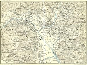
Condition: Good. MERANO & ENVIRONS. Vintage map plan. Italy 1927 old vintage chart. Coloured vintage map; Muirhead, James, Findlay & Russell (Blue guides) (1927). 15.0 x 20.0cm, 5.75 x 7.75 inches; this is a folding map. Condition: Good. Tight right margin; The image shown may have been taken from a different example of this map than that which is offered for sale. The map you will receive is in good condition but there may be minor variations in the condition from that shown in the image. There is nothing printed on the reverse side, which is plain.
-
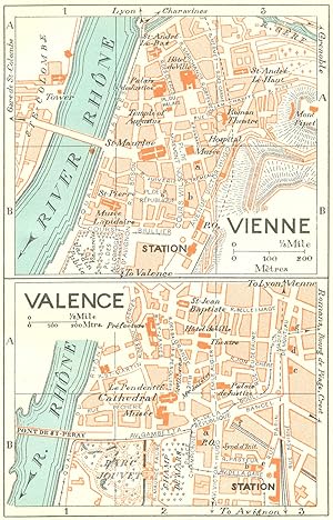
Condition: Good. FRANCE. Vienne; Valence 1926 old vintage map plan chart. Coloured vintage map; Muirhead, James, Findlay & Russell (Blue guides) (1926). 14.0 x 8.5cm, 5.5 x 3.5 inches. Condition: Good. The image shown may have been taken from a different example of this map than that which is offered for sale. The map you will receive is in good condition but there may be minor variations in the condition from that shown in the image. There is nothing printed on the reverse side, which is plain.
-
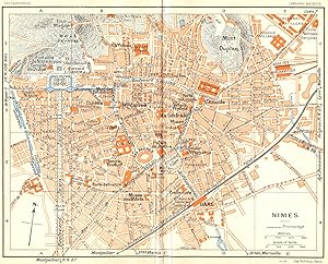
Condition: Good. PROVENCE. Nimes 1926 old vintage map plan chart. Coloured vintage map; Muirhead, James, Findlay & Russell (Blue guides) (1926). 15.0 x 18.5cm, 5.75 x 7.25 inches; this is a folding map. Condition: Good. The image shown may have been taken from a different example of this map than that which is offered for sale. The map you will receive is in good condition but there may be minor variations in the condition from that shown in the image. There is nothing printed on the reverse side, which is plain.
-
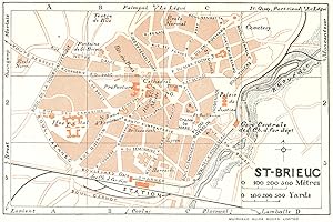
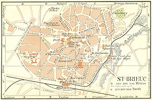
Condition: Good. BRITTANY. Bretagne. St Brieuc 1928 old vintage map plan chart. Coloured vintage map; Drawn by L. Hermann, Delt (1928). 8.5 x 13.0cm, 3.25 x 5 inches. Condition: Good. The image shown may have been taken from a different example of this map than that which is offered for sale. The map you will receive is in good condition but there may be minor variations in the condition from that shown in the image. There is nothing printed on the reverse side, which is plain.
-
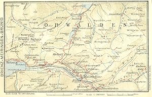
Condition: Good. SWITZERLAND. Brienz-Meiringen-Brunig 1923 old antique vintage map plan chart. Coloured vintage map; Muirhead, James, Findlay & Russell (Blue guides) (1923). 9.0 x 14.5cm, 3.5 x 5.75 inches. Condition: Good. The image shown may have been taken from a different example of this map than that which is offered for sale. The map you will receive is in good condition but there may be minor variations in the condition from that shown in the image. There is nothing printed on the reverse side, which is plain.
-
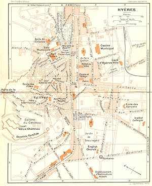
Condition: Good. FRANCE. Hyeres 1926 old vintage map plan chart. Coloured vintage map; Muirhead, James, Findlay & Russell (Blue guides) (1926). 18.0 x 14.5cm, 7 x 5.75 inches; this is a folding map. Condition: Good. Minor offsetting -text and/or images from the facing page have left an impression on the print; The image shown may have been taken from a different example of this map than that which is offered for sale. The map you will receive is in good condition but there may be minor variations in the condition from that shown in the image. There is nothing printed on the reverse side, which is plain.
-
Condition: Good. BRITTANY. St Brieuc 1932 old vintage map plan chart. Coloured vintage map; Muirhead, James, Findlay & Russell (Blue guides) (1932). 9.0 x 13.5cm, 3.5 x 5.25 inches. Condition: Good. The image shown may have been taken from a different example of this map than that which is offered for sale. The map you will receive is in good condition but there may be minor variations in the condition from that shown in the image. There is nothing printed on the reverse side, which is plain.
-
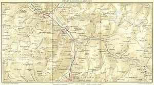
Condition: Good. SWITZERLAND. Ragatz-Coire-Klosters 1923 old antique vintage map plan chart. Coloured vintage map; Muirhead, James, Findlay & Russell (Blue guides) (1923). 14.5 x 26.5cm, 5.75 x 10.5 inches; this is a folding map. Condition: Good. The image shown may have been taken from a different example of this map than that which is offered for sale. The map you will receive is in good condition but there may be minor variations in the condition from that shown in the image. There is nothing printed on the reverse side, which is plain.
-
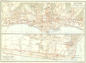
Condition: Good. SAN REMO & BORDIGHERA. Vintage town city map plans. Italy 1927 old vintage. Coloured vintage map; Muirhead, James, Findlay & Russell (Blue guides) (1927). 14.5 x 20.0cm, 5.75 x 7.75 inches; this is a folding map. Condition: Good. The image shown may have been taken from a different example of this map than that which is offered for sale. The map you will receive is in good condition but there may be minor variations in the condition from that shown in the image. There are images and/or text printed on the reverse side of the picture. In some cases this may be visible on the picture itself or around the margin of the picture.
-
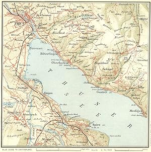
Condition: Good. SWITZERLAND. Environs of Thun 1923 old antique vintage map plan chart. Coloured vintage map; Muirhead, James, Findlay & Russell (Blue guides) (1923). 14.5 x 14.0cm, 5.5 x 5.5 inches; this is a folding map. Condition: Good. The image shown may have been taken from a different example of this map than that which is offered for sale. The map you will receive is in good condition but there may be minor variations in the condition from that shown in the image. There is nothing printed on the reverse side, which is plain.
-
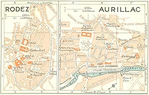
Condition: Good. FRANCE. Rodez; Aurillac 1926 old vintage map plan chart. Coloured vintage map; Muirhead, James, Findlay & Russell (Blue guides) (1926). 8.5 x 14.0cm, 3.5 x 5.5 inches. Condition: Good. The image shown may have been taken from a different example of this map than that which is offered for sale. The map you will receive is in good condition but there may be minor variations in the condition from that shown in the image. There is nothing printed on the reverse side, which is plain.
-
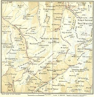
Condition: Good. SWITZERLAND. Fionnay-Arolla 1923 old antique vintage map plan chart. Coloured vintage map; Muirhead, James, Findlay & Russell (Blue guides) (1923). 14.5 x 14.0cm, 5.75 x 5.5 inches; this is a folding map. Condition: Good. Tight top margin; The image shown may have been taken from a different example of this map than that which is offered for sale. The map you will receive is in good condition but there may be minor variations in the condition from that shown in the image. There is nothing printed on the reverse side, which is plain.
-
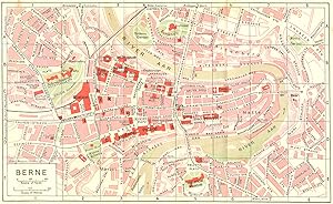
Condition: Good. SWITZERLAND. Berne 1923 old antique vintage map plan chart. Coloured vintage map; Muirhead, James, Findlay & Russell (Blue guides) (1923). 13.5 x 22.5cm, 5.25 x 8.75 inches; this is a folding map. Condition: Good. The image shown may have been taken from a different example of this map than that which is offered for sale. The map you will receive is in good condition but there may be minor variations in the condition from that shown in the image. There is nothing printed on the reverse side, which is plain.
-
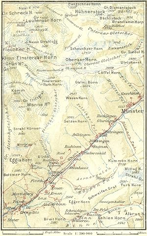
Condition: Good. SWITZERLAND. Eggishorn-Munster 1923 old antique vintage map plan chart. Coloured vintage map; Muirhead, James, Findlay & Russell (Blue guides) (1923). 14.0 x 8.5cm, 5.5 x 3.5 inches. Condition: Good. The image shown may have been taken from a different example of this map than that which is offered for sale. The map you will receive is in good condition but there may be minor variations in the condition from that shown in the image. There is nothing printed on the reverse side, which is plain.
-
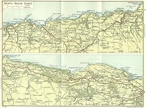
Condition: Good. DEVON. North Coast 1924 old vintage map plan chart. Colour vintage map; John Bartholomew & Son (1924). 14.5 x 20.0cm, 5.75 x 7.75 inches; this is a folding map. Condition: Good. The image shown may have been taken from a different example of this map than that which is offered for sale. The map you will receive is in good condition but there may be minor variations in the condition from that shown in the image. There is nothing printed on the reverse side, which is plain.
-
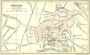
Condition: Good. HEREFORD. Town Plan 1924 old vintage map chart. Colour vintage map; John Bartholomew & Son (1924). 8.5 x 14.5cm, 3.5 x 5.75 inches. Condition: Good. The image shown may have been taken from a different example of this map than that which is offered for sale. The map you will receive is in good condition but there may be minor variations in the condition from that shown in the image. There is nothing printed on the reverse side, which is plain.
-
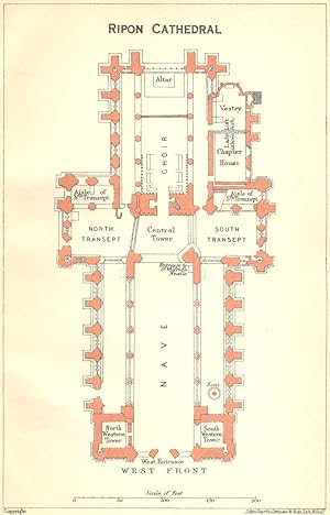
Condition: Good. YORKS. Ripon cathedral 1924 old vintage map plan chart. Colour vintage map; John Bartholomew & Son (1924). 14.5 x 9.0cm, 5.5 x 3.5 inches. Condition: Good. The image shown may have been taken from a different example of this map than that which is offered for sale. The map you will receive is in good condition but there may be minor variations in the condition from that shown in the image. There is nothing printed on the reverse side, which is plain.
-
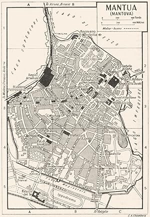
Condition: Good. MANTUA town/city plan. Italy 1953 old vintage map chart. Vintage map; E.A. Chambers (1953). 13.0 x 9.0cm, 5 x 3.5 inches. Condition: Good. Verso text quite apparent; The image shown may have been taken from a different example of this map than that which is offered for sale. The map you will receive is in good condition but there may be minor variations in the condition from that shown in the image. There are images and/or text printed on the reverse side of the picture. In some cases this may be visible on the picture itself or around the margin of the picture.
-
Condition: Good. PARMA town/city plan. Italy 1953 old vintage map chart. Vintage map; E.A. Chambers (1953). 9.0 x 13.0cm, 3.5 x 5 inches. Condition: Good. Verso text quite apparent; The image shown may have been taken from a different example of this map than that which is offered for sale. The map you will receive is in good condition but there may be minor variations in the condition from that shown in the image. There are images and/or text printed on the reverse side of the picture. In some cases this may be visible on the picture itself or around the margin of the picture.
-
Condition: Good. NORTHANTS. Peterborough cathedral 1924 old vintage map plan chart. Colour vintage map; John Bartholomew & Son (1924). 14.5 x 9.5cm, 5.75 x 3.75 inches. Condition: Good. The image shown may have been taken from a different example of this map than that which is offered for sale. The map you will receive is in good condition but there may be minor variations in the condition from that shown in the image. There is nothing printed on the reverse side, which is plain.
-
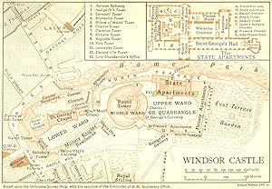
Condition: Good. BERKS. Windsor Castle 1924 old vintage map plan chart. Colour vintage map; Emery Walker Ltd Sc (1924). 9.5 x 14.0cm, 3.75 x 5.5 inches. Condition: Good. The image shown may have been taken from a different example of this map than that which is offered for sale. The map you will receive is in good condition but there may be minor variations in the condition from that shown in the image. There is nothing printed on the reverse side, which is plain.
-
Condition: Good. CREMONA town/city plan. Italy 1953 old vintage map chart. Vintage map; E.A. Chambers (1953). 9.0 x 12.5cm, 3.5 x 5 inches. Condition: Good. Verso text quite apparent; The image shown may have been taken from a different example of this map than that which is offered for sale. The map you will receive is in good condition but there may be minor variations in the condition from that shown in the image. There are images and/or text printed on the reverse side of the picture. In some cases this may be visible on the picture itself or around the margin of the picture.
-
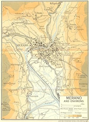
Condition: Good. Merano and Environs 1953 old vintage map plan chart. Colour vintage map; John Bartholomew & Son (1953). 19.0 x 14.0cm, 7.5 x 5.5 inches; this is a folding map. Condition: Good. The image shown may have been taken from a different example of this map than that which is offered for sale. The map you will receive is in good condition but there may be minor variations in the condition from that shown in the image. There is nothing printed on the reverse side, which is plain.
-
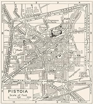
Condition: Good. PISTOIA town/city plan. Italy 1953 old vintage map chart. Vintage map; John Bartholomew & Son (1953). 10.0 x 9.0cm, 4 x 3.5 inches. Condition: Good. Verso text quite apparent; The image shown may have been taken from a different example of this map than that which is offered for sale. The map you will receive is in good condition but there may be minor variations in the condition from that shown in the image. There are images and/or text printed on the reverse side of the picture. In some cases this may be visible on the picture itself or around the margin of the picture.
-
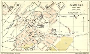
Condition: Good. KENT. Canterbury Town Plan 1924 old vintage map chart. Colour vintage map; John Bartholomew & Son (1924). 9.0 x 14.5cm, 3.5 x 5.75 inches. Condition: Good. The image shown may have been taken from a different example of this map than that which is offered for sale. The map you will receive is in good condition but there may be minor variations in the condition from that shown in the image. There is nothing printed on the reverse side, which is plain.
-
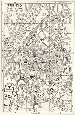
Condition: Good. TRENTO town/city plan. Italy 1953 old vintage map chart. Vintage map; John Bartholomew & Son (1953). 13.5 x 9.0cm, 5.25 x 3.5 inches. Condition: Good. Verso text quite apparent; The image shown may have been taken from a different example of this map than that which is offered for sale. The map you will receive is in good condition but there may be minor variations in the condition from that shown in the image. There are images and/or text printed on the reverse side of the picture. In some cases this may be visible on the picture itself or around the margin of the picture.
-
Condition: Good. WINDSOR CASTLE. Vintage map plan. Berkshire 1950 old vintage chart. Vintage colour map; Based on the Ordnance Survey map. Printed by Maglagan & Cumming (1950). 9.0 x 14.0cm, 3.5 x 5.5 inches. Condition: Good. There is nothing printed on the reverse side, which is plain.
-
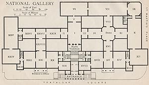
Condition: Good. NATIONAL GALLERY. Vintage map plan. London 1922 old antique chart. Vintage print; Muirhead, James, Findlay & Russell (Blue guides) (1922). 8.0 x 14.0cm, 3 x 5.5 inches. Condition: Good. There is nothing printed on the reverse side, which is plain.
-
Condition: Good. Merano and Environs 1960 old vintage map plan chart. Vintage colour map; Muirhead, James, Findlay & Russell (Blue guides) (1960). 19.0 x 14.0cm, 7.5 x 5.5 inches; this is a folding map. Condition: Good. The image shown may have been taken from a different example of this map than that which is offered for sale. The map you will receive is in good condition but there may be minor variations in the condition from that shown in the image. There is nothing printed on the reverse side, which is plain.
-
Condition: Good. SAN REMO & BORDIGHERA. Vintage town city map plans. Italy 1924 old vintage. Vintage colour map; Scale 1:13,000; Scale 1:13,000; Muirhead, James, Findlay & Russell (Blue guides) (1924). 15.0 x 20.0cm, 5.75 x 7.75 inches; this is a folding map. Condition: Good. There are images and/or text printed on the reverse side of the picture. In some cases this may be visible on the picture itself or around the margin of the picture.