Order Total (1 Item Items):
Shipping Destination:

Lisle Guillaume Philippe Buache (6 results)
Skip to main search results
Product Type
- All Product Types
- Books (5)
- Magazines & Periodicals
- Comics
- Sheet Music
- Art, Prints & Posters
- Photographs
- Maps (1)
-
Manuscripts &
Paper Collectibles
Condition
- All Conditions
- New
- Used
Binding
- All Bindings
- Hardcover
- Softcover
Collectible Attributes
- First Edition (1)
- Signed
- Dust Jacket
- Seller-Supplied Images (5)
- Not Printed On Demand
Seller Location
Seller Rating
-
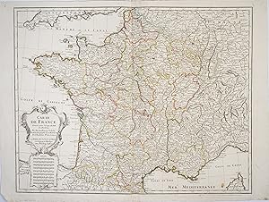
Condition: A. Trčs élégante carte de France de Delisle au contours coloriés ŕ l'époque.La carte s'étend de l'Atlantique aux Alpes et du Sud de l'Angleterre ŕ l'Espagne. Elle présente un élégant cartouche de titre aux armes du roi de France ŕ qui la carte est dédiée. Petit manque de papier dans l'angle inférieur gauche, une petite tache. // ENGLISH // Very elegant map of France by Delisle with contours colored at the time. The map extends from the Atlantic to the Alps and from the south of England to Spain. It features an elegant title cartouche with the arms of the king of France to whom the map is dedicated. Small paper loss in the lower left corner, a small stain.
-
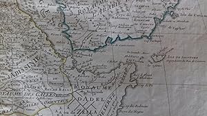
Carte de l'Egypte, de la Nubie, de l'Abissinie &c par Guillaume De lisle de l'Academie R. des Sciences (antique map of Egypt, Nubia, Abyssinia, etc.)
Published by Dezauche, Paris, 1780
First Edition
A stunning map of Arabia and northeastern Africa (from Libya and Egypt in the north to Somalia and the Gulf of Guinea in the south). 50 x 62 cm (plate), 55 x 76 cm (sheet). Arabia, Egypt, Sudan, and Abyssinia (Ethiopia) are wonderfully detailed; the interior much less so, with some marvelously cryptic comments ("Desert de Berdoa, d'une grande sécheresse, oů il n'y a pas de sűreté pour les marchands ŕ cause de voleurs"; "Royaume de Témian, dont les habitans sont ŕ ce qu'on dit Antropophages.") Printed on fine, thick watermarked laid paper. Original outline color. Reverse blank. A fine impression. Three small faint stains in the upper margin that could easily be removed, and that in any case would be invisible were the map matted and framed), else A PRISTINE EXAMPLE, with the paper FINE AND BRIGHT. Very scarce in such fine condition.
-
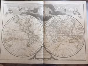
Mappamonde a l'usage de l'instruction par. Premiers Geógraphes et de l'Academie des Sciences. Revue et Augmentée des N.les Decouvertes par Dezauche en 1808.
Published by Chez Dezauche Geographe,, Paris,, 1808
Seller: Llibreria Antiquŕria Delstres, Canet de Mar, BCN, Spain
Seller Rating:

"Advertissement. On a ajouté ŕ cette Mappamonde les Nouvelles Découvertes faites par le Capitain Cook dans ses trois différens Voyages, ainst que celles faites depuis 30 ans, par les plus célčbres Voyageurs, soit au Sud du Cap de Bonne Esperance, soit du Nord de la Grande Mer, appellée vulgairement la Mer du Sud.". Mapa grabado a doble hoja, folio imperial. Ligeras restauraciones en el centro del pliego y en la esquina derecha casi imperceptibles, pequeńos puntos de óxido; reforzado en el reverso del mapa con papel cartulina. Buen estado en general. 50,5x75 cm.
-
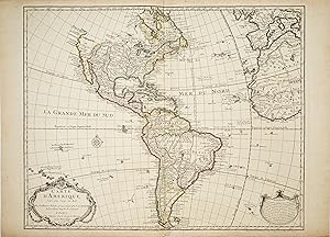
Condition: Bon. La carte de l'Amérique de Guillaume Delislepar Philippe Buache Guillaume Delisle (de l'Isle) (1675-1726), est l'une des plus grandes figures de la cartographie française.Fils aîné de l'historien et géographe Claude Delisle dont il fut l'élčve, il entra ŕ l'Académie des Sciences en 1702 pour y étudier auprčs de l'astronome Jean-Dominique Cassini. Il enseigna la géographie au jeune Louis XV et fut le premier ŕ recevoir le titre de Premier Géographe du Roi en 1718. Un des apports principaux de Delisle est d'opérer une transition des cartes décoratives de l'école Hollandaise vers une approche plus scientifique. Afin de donner une cartographie la plus exacte et précise possible, Delisle réunit avec soin toutes les informations disponibles des plus anciennes aux plus récentes pour réaliser ses cartes. Il les mettra constamment ŕ jours au cours de sa vie afin de refléter les nouvelles découvertes. Ainsi ses cartes donnent un aperçu précis de l'état des connaissances géographiques de l'époque.Un autre apport majeur de Delisle a été de rassembler et d'incorporer ces informations latitudinales et longitudinales dans ses cartes, établissant un nouveau standard de précision, rapidement suivi par nombre de ses contemporains. Il est ŕ l'origine de la cartographie moderne. Tooley - The mapping of America p.13 // ENGLISH // Guillaume Delisle's map of America by Philippe Buache Guillaume Delisle (de l'Isle) (1675-1726), is one of the greatest figures of French cartography.He was the eldest son of the historian and geographer Claude Delisle, and was his pupil. He entered the Académie des Sciences in 1702 to study with the astronomer Jean-Dominique Cassini. He taught geography to the young Louis XV and was the first to receive the title of Premier Géographe du Roi in 1718. One of Delisle's main contributions was to make a transition from the decorative maps of the Dutch school to a more scientific approach. In order to provide the most accurate and precise cartography possible, Delisle carefully gathered all available information from the oldest to the most recent to produce his maps. He would constantly update them during his lifetime to reflect new discoveries. Thus his maps give an accurate overview of the state of geographical knowledge at the time.Another major contribution of Delisle was to gather and incorporate this latitudinal and longitudinal information into his maps, setting a new standard of accuracy, which was quickly followed by many of his contemporaries. He was the originator of modern cartography. Tooley - The mapping of America p.13.
-

Carte de l'Egypte de la Nubie de l'Abissinie &c.
Published by Paris, Philippe Buache, 1745., 1745
Seller: Antiquariat INLIBRIS Gilhofer Nfg. GmbH, Vienna, A, Austria
Association Member: ILAB VDA VDAO
Seller Rating:

Hand-coloured engraved map (635 x 505 mm). A fine example of Philippe Buache's edition of Guillaume de l'Isles highly detailed map of the region centered on the Red Sea. The map extends west to include Sicily, the Southeastern Mediterreanean, Barbaria, Nigritie, and a Guinea on the West Coast of Africa. To the east, the map includes the Persian Gulf, Saudi Arabia, the Gulf of Aden and the Kingdom of Ajan and Dadel. De l'Isle's maps provided the first truly scientific mapping of the regions covered, showing the flamboyant Dutch style of illustrations and adopting a highly detailed and decorative approach to the printed map. The result is a combination of spectacular detail and accuracy, not approached by the Dutch or any other 17th Century map makers. The detail in this map reflects this Renaissance of style and accuracy. - Tibbetts 199. Cf. Al-Qasimi 268 (1707 ed.).
-

Carte du Canada ou de la Nouvelle France et des Decouvertes qui y ont ete faites.
Published by c. 1718, Paris, 1718
Seller: Alexandre Antique Prints, Maps & Books, Toronto, ON, Canada
Seller Rating:

Map
Condition: Very Good. Fifth State. Scarce. "De l'Isle's map of Canada is one of the most outstanding maps of Canada of the 17th and early 18th centuries. Typical of all of his work, the information that went into his map of Canada was the result of careful and painstaking research. It thus seems somewhat surprising that the dubious discoveries of Lahontan should have been so readily accepted and included on his map of Canada. De l'Isle's careful research resulted in the first map of Canada to present the whole of the Great Lakes correctly. In addition, the position of the lakes relative to Hudson Bay is also correct, and the Avalon Peninsula is shown much more realistically than in previous maps of Canada. Of considerable significance, the geography of the coastal regions of James and Hudson Bays, together with their major river systems is presented b De l'Isle with a surprising degree of accuracy."-Kershaw I page 275., Size : 497x645 (mm), 19.57x25.39 (Inches), Hand Colored, 0.