Order Total (1 Item Items):
Shipping Destination:

Lisle Guillaume Others (2 results)
Skip to main search results
Product Type
- All Product Types
- Books (2)
- Magazines & Periodicals
- Comics
- Sheet Music
- Art, Prints & Posters
- Photographs
- Maps
-
Manuscripts &
Paper Collectibles
Condition
- All Conditions
- New
- Used
Binding
- All Bindings
- Hardcover
- Softcover
Collectible Attributes
- First Edition
- Signed
- Dust Jacket
- Seller-Supplied Images (1)
- Not Printed On Demand
Seller Location
Seller Rating
-
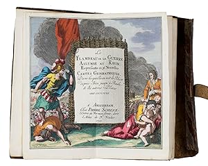
Le flambeau de la guerre allumee au Rhin; representee en 36 nouvelles cartes geographiques, = De fakkel des oorlogs ontstoken aan den Rhyn; verbeeld in 36 nieuwe geographische landkaarten, Amsterdam, Petrus Schenk II, 1735. 8vo. With a double-page engraved title, two double-page engraved pages of text in Dutch and French, a folding engraved map and 36 double-page engraved maps; all coloured by hand. Original publisher's red sheepskin with a flap and wrapping band.
Seller: ASHER Rare Books, T Goy Houten, Netherlands
Seller Rating:

Very rare pocket atlas of the Rhine-area between Cologne in the north and Basel, published for use by military officers and civilian travellers and based on maps prepared by Guillaume de l'Isle (1675-1725) during the War of the Spanish Succession (1701-1714). A folding map shows the entire region and identifies the separate maps. The publisher promises in the introduction that all 36 maps combined will result in a "very large map": ca. 140 x 65 cm.The present pocket atlas, marketed for travellers, was sold ready bound and coloured, as opposed to the common practice of selling books in loose sheets. Schenk published a second edition in 1744 with several corrections and an extra map.The British Captain George Howard (1718-1796) bought the present copy on 10 August 1743, probably at the bookshop of Philipp Heinrich Hutter in Frankfurt. Howard served in the 3rd regiment of foot ("The Buffs") under his father Thomas Howard and had just participated in the Battle of Dettingen (May 1743) during the War of the Austrian Succession (1740-1748) when he bought this atlas. He would later command the Buffs at the Battle of Fontenoy (1745) and at Falkirk Muir and Culloden (1746). After the wars he became an MP and was ultimately promoted to Field Marshal in 1793. Loosely inserted in a pocket of the atlas is a note in Howard's hand describing on one side the affairs on 10-13 August 1743 and on the other side his expenses in July and August 1743. The pocket atlas is probably noted as "a book of maps" on 11 August.With the owner's inscription of George Howard on the paste-down and a leaf containing notes in his hand loosely inserted in the front pocket. A later slip of paper containing a manuscript title and shelfmarks is mounted on the back board. Headbands slightly worn, otherwise in very good condition.l Koeman III, Sche 10; Maandelyke uitreksels; of Boekzaal der geleerde waerelt XL (April 1735), pp. 484-485; STCN (1 copy), WorldCat (5 copies).
-

Folio. 80 Engraved double-page maps with original hand-colour in outline. Contemporary mottled calf (extremities worn). A composite atlas, sold as a collection of maps. With a number of extremely important maps by de l'Isle pertaining to America: "Carte d'Amerique" 1722 (Tooley America state 2 with title in plain black lettering), "Carte du Canada ou de la Nouvelle France" (with address "sur le Quai de l'Horloge a l'Aigle dOr" Tooley 36), "Carte de la Louisiane" (first plate, second state with New Orleans, and as such one of the most important maps of the American West, based on the maps of La Salle, Spanish expeditions and maps from Le Moyne, "Carte de Mexique" (Renard's imprint has been erased, with "A Paris Ch�z l'Auteur sur le Quai de l'Horloge" Tooley 50), "Bresil" 1703 (with address '' sur le Quai de l'Horloge a l'Aigle d'Or), "Paraguay du Chili" 1703, "Saint Domingue" 1725, "Martinique" 1732. Also with: NOLIN/CORONELLI "Le globe terrestre represent�. " 1742 (Shirley 546), De L'ISLE / BAUCHE "Mappe Monde" 15 April 1720, North Pole, South Pole, Europe, NOLIN / CORONELLI "Les Royaumes de Suede de Danemarck, et de Norwege" with inset of Iceland 1742, BUACHE "Courones du Nord", BUACHE "Courones du Nord", BUACHE "Moscovie", BUACHE "Danemarck", BUACHE "Pologne" 1703, BUACHE "Les Isles Britaniques a l'Aigle d'Or", BUACHE "Pays Bas" 1702, BAUCHE "Pays Bas Catholiques" 1702, BUACHE "Frandre" 1704, BUACHE "Brabant" 1705, BUACHE "Hinaut, Namur", NOLIN/CORONELLI "Luxembourg" 1742, BUACHE "Allemagne", HOMANN "Danubi", NOLIN / CORONELLI "Boheme", Fifteen maps by BUACHE of France with a plan of Paris, BUACHE Spain & Portugal 1741, NOLIN / CORONELLI "Catalogne" 1694, BUACHE Switserland 1713, BUACHE Italy, BUACHE "Piemonte" 1707, BUACHE "Piemont" 1745, NOLIN / CORONELLI Milan 1740, NOLIN / CORONELLI "Du Cours du Po" with Istrie 1742, De L'ISLE Sicily with inset map of Malta 1717, BUACHE "Hongie, Croatie", BUACHE "Carte de la Hongrie" 1703, BUACHE "Carte de la Grece" 1745, De L'ISLE "Asie" 1723, De L'ISLE "Tartarie" 1706, BUACHE "Turque Arabie" 1745, BUACHE "Perse" 1724, De L'ISLE "Mer Caspiene" 1723, BUACHE "Carte des Indes et de la Chine" 1745, De L'ISLE Malabar 1723, De L'ISLE "Afrique" 1722, DE, L'ISLE "Carte de la Barbariede la Nigritie", De L'ISLE Senegal 1727, De L'ISLE "Egypte", with address l'Aigle d'Or 1707, De L'ISLE "Conge de Cafres" 1708. Maps of the historical world include De L'ISLE's "Theatrum Historicum" 1705, "Theatrum Historicum" 1705, "Graciae Septentrionalium", 1708, "Graciae Meridionalis" 1707, "Tabula Italia Antiquae" 1715, "Alexandri Magni Imperium" 1731 (with marginal stain), "Alexandri Magni Imperium" 1731 (with marginal stain). Catalogued by Kate Hunter.