Order Total (1 Item Items):
Shipping Destination:

Julian Stafford Corbett (794 results)
Skip to main search results
Product Type
- All Product Types
- Books (707)
- Magazines & Periodicals
- Comics
- Sheet Music
- Art, Prints & Posters
- Photographs
- Maps (87)
-
Manuscripts &
Paper Collectibles
Condition
Binding
Collectible Attributes
Free Shipping
Seller Location
Seller Rating
-

Sir Francis Drake
Published by CreateSpace Independent Publishing Platform, 2016
ISBN 10: 1534629726ISBN 13: 9781534629721
Book
Condition: As New. Unread book in perfect condition.
More buying choices from other sellers on AbeBooks
New offers from � 9.23
Used offers from � 8.08
Also find Softcover
-

Fighting Instructions, 1530-1816
Published by CreateSpace Independent Publishing Platform, 2016
ISBN 10: 1523943157ISBN 13: 9781523943159
Book
Condition: As New. Unread book in perfect condition.
More buying choices from other sellers on AbeBooks
New offers from � 10.02
Used offers from � 9
Also find Softcover
-
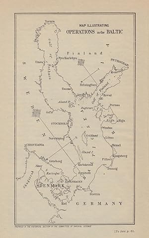
Condition: Good. Map illustrating operations in the Baltic 1915. First World War. 1923 old. Antique military history map; Map compiled by Sir Julian Stafford Corbett. Published by Ordnance Survey 1923 (1923). 18.5 x 11.5cm, 7.25 x 4.5 inches. Condition: Good. There is nothing printed on the reverse side, which is plain.
-

Signals and instructions, 1776-1794
Published by United States Naval Institute, 1971
ISBN 10: 0870218778ISBN 13: 9780870218774
Seller: Ed's Editions LLC, ABAA, West Columbia, SC, U.S.A.
Seller Rating:

Book
Hardcover. Condition: Very Good. Dust Jacket Condition: Very Good. Dust jacket with protective wrapper- no chipping or rips to jacket. Clean, has a good binding, no marks or notations. *LO (listed area).
More buying choices from other sellers on AbeBooks
Used offers from � 12.17
-
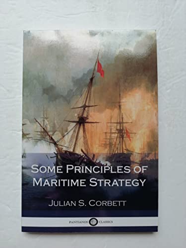
Some Principles of Maritime Strategy
Published by CreateSpace Independent Publishing Platform, 2017
ISBN 10: 197936902XISBN 13: 9781979369022
Book
Paperback. Condition: Very Good. The book has been read, but is in excellent condition. Pages are intact and not marred by notes or highlighting. The spine remains undamaged.
-
![Seller image for [Position at] 1.30 P. M [Battle of the Falkland Islands] for sale by Antiqua Print Gallery](https://pictures.abebooks.com/inventory/md/md31543335322.jpg)
Condition: Good. Battle of the Falkland Islands. 1.30pm, 8th December 1914. WW1. 1920 old map. Antique military history map; Map compiled by Sir Julian Stafford Corbett. Published by Ordnance Survey 1919 (1920). 19.5 x 12.0cm, 7.75 x 4.75 inches. Condition: Good. There is nothing printed on the reverse side, which is plain.
-
![Seller image for [Position in] Main Action 4.17 P. M to 4.24 P. M [Battle of the Falkland Islands] for sale by Antiqua Print Gallery](https://pictures.abebooks.com/inventory/md/md31543335323.jpg)
[Position in] Main Action 4.17 P. M to 4.24 P. M [Battle of the Falkland Islands]
Publication Date: 1920
Map
Condition: Good. Battle of the Falkland Islands. 4.17-4.24pm, 8th December 1914. WW1. 1920 map. Antique military history map; Map compiled by Sir Julian Stafford Corbett. Published by Ordnance Survey 1919 (1920). 13.0 x 12.5cm, 5 x 5 inches. Condition: Good. There is nothing printed on the reverse side, which is plain.
-
![Seller image for [Position in] Main Action 4.44 P. M to 5.01 P. M [Battle of the Falkland Islands] for sale by Antiqua Print Gallery](https://pictures.abebooks.com/inventory/md/md31543335324.jpg)
[Position in] Main Action 4.44 P. M to 5.01 P. M [Battle of the Falkland Islands]
Publication Date: 1920
Map
Condition: Good. Battle of the Falkland Islands. 4.44-5.01pm, 8th December 1914. WW1. 1920 map. Antique military history map; Map compiled by Sir Julian Stafford Corbett. Published by Ordnance Survey 1919 (1920). 15.0 x 12.5cm, 6 x 5 inches. Condition: Good. There is nothing printed on the reverse side, which is plain.
-
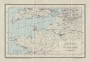
Condition: Good. Map illustrating the shift of base to St Nazaire 1914. First World War. 1920. Antique military history map; Map compiled by Sir Julian Stafford Corbett. Published by Ordnance Survey 1919 (1920). 18.0 x 26.0cm, 7 x 10.25 inches. Condition: Good. There is nothing printed on the reverse side, which is plain.
-
![Seller image for Operations near Kurnah [Al Qurnah - Mesopotamian Campaign] for sale by Antiqua Print Gallery](https://pictures.abebooks.com/inventory/md/md31543340007.jpg)
Condition: Good. Battle of Qurnah, December 1914. Kurnah. Mesopotamian Campaign. Iraq 1920 map. Antique military history map; Map compiled by Sir Julian Stafford Corbett. Published by Ordnance Survey 1919 (1920). 12.0 x 11.5cm, 4.75 x 4.5 inches. Condition: Good. There is nothing printed on the reverse side, which is plain.
-
![Seller image for [Position at] 12.51 P. M "Open Fire" [Battle of the Falkland Islands] for sale by Antiqua Print Gallery](https://pictures.abebooks.com/inventory/md/md31543341016.jpg)
Condition: Good. Battle of the Falkland Islands. 12.51pm, 8th December 1914. WW1. 1920 old map. Antique military history map; Map compiled by Sir Julian Stafford Corbett. Published by Ordnance Survey 1919 (1920). 19.0 x 12.0cm, 7.5 x 4.75 inches. Condition: Good. There is nothing printed on the reverse side, which is plain.
-
![Seller image for [Action between] Kent & N�rnberg 5.35 P. M to 6.36 P. M [Battle of the Falkland Islands] for sale by Antiqua Print Gallery](https://pictures.abebooks.com/inventory/md/md31543341017.jpg)
[Action between] Kent & N�rnberg 5.35 P. M to 6.36 P. M [Battle of the Falkland Islands]
Publication Date: 1920
Map
Condition: Good. Battle of the Falkland Islands. Kent & N�rnberg, 8th Dec. 1914. WW1. 1920 map. Antique military history map; Map compiled by Sir Julian Stafford Corbett. Published by Ordnance Survey 1919 (1920). 11.0 x 16.0cm, 4.5 x 6.25 inches. Condition: Good. There is nothing printed on the reverse side, which is plain.
-
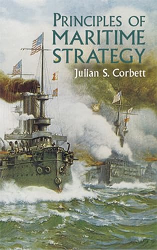
Principles of Maritime Strategy
Published by Dover Publications, 2004
ISBN 10: 0486437434ISBN 13: 9780486437439
Book
Befriedigend/Good: Durchschnittlich erhaltenes Buch bzw. Schutzumschlag mit Gebrauchsspuren, aber vollst�ndigen Seiten. / Describes the average WORN book or dust jacket that has all the pages present.
More buying choices from other sellers on AbeBooks
New offers from � 18.34
Used offers from � 9.06
Also find Softcover
-
![Seller image for Operations near Basra [Mesopotamian Campaign] for sale by Antiqua Print Gallery](https://pictures.abebooks.com/inventory/md/md31543333553.jpg)
Condition: Good. Operations near Basra. Mesopotamian Campaign, Iraq 1914. WW1. 1920 old map. Antique military history map; Map compiled by Sir Julian Stafford Corbett. Published by Ordnance Survey 1919 (1920). 12.0 x 12.0cm, 4.75 x 4.75 inches. Condition: Good. There is nothing printed on the reverse side, which is plain.
-
![Seller image for Sketch Plan of Tekke Beach at the Date of Evacuation [Gallipoli or Dardanelles Campaign] for sale by Antiqua Print Gallery](https://pictures.abebooks.com/inventory/md/md31543342013.jpg)
Sketch Plan of Tekke Beach at the Date of Evacuation [Gallipoli or Dardanelles Campaign]
Publication Date: 1923
Map
Condition: Good. Tekke Beach at evacuation, 1915-1916. Gallipoli Campaign. WW1. 1923 old map. Antique military history map; Map compiled by Sir Julian Stafford Corbett. Published by Ordnance Survey 1922 (1923). 11.5 x 19.0cm, 4.5 x 7.5 inches. Condition: Good. There is nothing printed on the reverse side, which is plain.
-
![Seller image for Sketch Plan of Helles Beach [Cape Helles] at the Date of Evacuation [Gallipoli or Dardanelles Campaign] for sale by Antiqua Print Gallery](https://pictures.abebooks.com/inventory/md/md31543342014.jpg)
Sketch Plan of Helles Beach [Cape Helles] at the Date of Evacuation [Gallipoli or Dardanelles Campaign]
Publication Date: 1923
Map
Condition: Good. Helles Beach at evacuation, 1915-1916. Gallipoli Campaign. WW1. 1923 old map. Antique military history map; Map compiled by Sir Julian Stafford Corbett. Published by Ordnance Survey 1922 (1923). 11.0 x 19.0cm, 4.5 x 7.5 inches. Condition: Good. There is nothing printed on the reverse side, which is plain.
-

Some Principles of Maritime Strategy
Published by Naval and Military Press, 2009
ISBN 10: 1843426226ISBN 13: 9781843426226
Book
Condition: New.
More buying choices from other sellers on AbeBooks
New offers from � 15.50
Used offers from � 15.73
Also find Softcover
-
![Seller image for Map to illustrate Operations in the Akaika (Ukaikah) Channel [Mesopotamian Campaign] for sale by Antiqua Print Gallery](https://pictures.abebooks.com/inventory/md/md31543331807.jpg)
Map to illustrate Operations in the Akaika (Ukaikah) Channel [Mesopotamian Campaign]
Publication Date: 1923
Map
Condition: Good. Akaika/Ukaikah Channel operations, 1915. Mesopotamian Campaign. WW1. 1923 map. Antique military history map; Map compiled by Sir Julian Stafford Corbett. Published by Ordnance Survey 1922 (1923). 20.0 x 17.5cm, 7.75 x 7 inches; this is a folding map. Condition: Good. There is nothing printed on the reverse side, which is plain.
-

Sir Francis Drake
Published by Hardpress Publishing, 2013
ISBN 10: 131444431XISBN 13: 9781314444315
Book
PAP. Condition: New. New Book. Shipped from UK. Established seller since 2000.
More buying choices from other sellers on AbeBooks
New offers from � 18.52
-

Some Principles of Maritime Strategy
Published by Alpha Edition, 2024
ISBN 10: 9357966986ISBN 13: 9789357966986
Book
Condition: New.
More buying choices from other sellers on AbeBooks
New offers from � 16.51
Used offers from � 17.03
Also find Softcover
-

Some Principles of Maritime Strategy
Published by CreateSpace Independent Publishing Platform, 2015
ISBN 10: 1511671696ISBN 13: 9781511671699
Book
Condition: As New. Unread book in perfect condition.
More buying choices from other sellers on AbeBooks
New offers from � 29.77
Used offers from � 16.54
Also find Softcover
-
The Campaign of Trafalgar (Classic Reprint)
Published by Forgotten Books, 2018
ISBN 10: 1332920659ISBN 13: 9781332920655
Book
paperback. Condition: As New. 473 p., clean and unmarked anywhere on strong unaged paper; binding tight; glossy wrapper without discernible wear.
More buying choices from other sellers on AbeBooks
New offers from � 17.38
Used offers from � 15.41
Also find Softcover
-

Monk
Published by Alpha Edition, 2023
ISBN 10: 9357910565ISBN 13: 9789357910569
Book Print on Demand
PAP. Condition: New. New Book. Shipped from UK. THIS BOOK IS PRINTED ON DEMAND. Established seller since 2000.
More buying choices from other sellers on AbeBooks
New offers from � 18.84
-
The Campaign of Trafalgar, Vol. 2 of 2 (Classic Reprint)
Published by Forgotten Books, 2018
ISBN 10: 0282061339ISBN 13: 9780282061333
Book Print on Demand
Paperback. Condition: New. Print on Demand. Excerpt from The Campaign of Trafalgar. About the Publisher, Forgotten Books publishes hundreds of thousands of rare and classic books. This book is a reproduction of an important historical work. Forgotten Books uses state-of-the-art technology to digitally reconstruct the work, preserving the original format whilst repairing imperfections present in the aged copy. In rare cases, an imperfection in the original, such as a blemish or missing page, may be replicated in our edition. We do, however, repair the vast majority of imperfections successfully; any imperfections that remain are intentionally left to preserve the state of such historical works. This text has been digitally restored from a historical edition. Some errors may persist, however we consider it worth publishing due to the work's historical value. The digital edition of all books may be viewed on our website before purchase. print-on-demand item.
More buying choices from other sellers on AbeBooks
New offers from � 14.82
-

Hardcover. Condition: Very Good. Pristine. Hardcover in protective Mylar shows almost no wear. Text is unmarked and binding tight. We ship DAILY!.
More buying choices from other sellers on AbeBooks
New offers from � 87.22
Used offers from � 19.32
Also find Hardcover
-

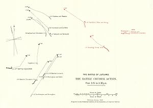
Condition: Good. Battle of Jutland. Battle Cruiser Action 2.45-3.00 pm 31 May 1916. WW1. 1923 map. Antique military history map; Map compiled by Sir Julian Stafford Corbett. Published by Ordnance Survey 1923 (1923). 15.5 x 33.5cm, 6 x 13 inches; this is a folding map. Condition: Good. There is nothing printed on the reverse side, which is plain.
-
Condition: Good. Battle of Jutland. Battle Cruiser Action 3.15-3.30 pm 31 May 1916. WW1. 1923 map. Antique military history map; Map compiled by Sir Julian Stafford Corbett. Published by Ordnance Survey 1923 (1923). 18.0 x 25.5cm, 7 x 10 inches; this is a folding map. Condition: Good. There is nothing printed on the reverse side, which is plain.
-
![Seller image for Map to illustrate the Battle of Kut 28th September 1915 [Mesopotamian Campaign] for sale by Antiqua Print Gallery](https://pictures.abebooks.com/inventory/md/md31543336285.jpg)
Map to illustrate the Battle of Kut 28th September 1915 [Mesopotamian Campaign]
Publication Date: 1923
Map
Condition: Good. Battle of Battle of Es Sinn, 28th September 1915. Kut. Mesopotamia Iraq 1923 map. Antique military history map; Map compiled by Sir Julian Stafford Corbett. Published by Ordnance Survey 1922 (1923). 24.5 x 19.5cm, 9.75 x 7.75 inches; this is a folding map. Condition: Good. There is nothing printed on the reverse side, which is plain.
-
![Seller image for S. M. S K�nigsberg in the Rufiji Delta [Battle of Rufiji Delta] for sale by Antiqua Print Gallery](https://pictures.abebooks.com/inventory/md/md31543336287.jpg)
Condition: Good. S.M.S. K�nigsberg. Battle of Rufiji Delta. 1914-1915. First World War. 1923 map. Antique military history map; Map compiled by Sir Julian Stafford Corbett. Published by Ordnance Survey 1923 (1923). 18.5 x 12.5cm, 7.25 x 4.75 inches. Condition: Good. There is nothing printed on the reverse side, which is plain.
-
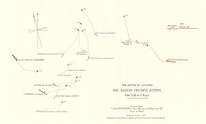
Condition: Good. Battle of Jutland. Battle Cruiser Action 3.00-3.15 pm 31 May 1916. WW1. 1923 map. Antique military history map; Map compiled by Sir Julian Stafford Corbett. Published by Ordnance Survey 1923 (1923). 17.5 x 29.0cm, 6.75 x 11.5 inches; this is a folding map. Condition: Good. There is nothing printed on the reverse side, which is plain.