Order Total (1 Item Items):
Shipping Destination:

Jan Jansson Johann Janssonius (3 results)
Feedback
Skip to main search results
Search filters
Product Type
- All Product Types
- Books (1)
- Magazines & Periodicals (No further results match this refinement)
- Comics (No further results match this refinement)
- Sheet Music (No further results match this refinement)
- Art, Prints & Posters (No further results match this refinement)
- Photographs (No further results match this refinement)
- Maps (2)
- Manuscripts & Paper Collectibles (No further results match this refinement)
Condition
- All Conditions
- New (No further results match this refinement)
- Used (3)
Binding
- All Bindings
- Hardcover (No further results match this refinement)
- Softcover (No further results match this refinement)
Collectible Attributes
- First Edition (No further results match this refinement)
- Signed (No further results match this refinement)
- Dust Jacket (No further results match this refinement)
- Seller-Supplied Images (2)
- Not Print on Demand (3)
Free Shipping
- Free Shipping to United Kingdom (No further results match this refinement)
Seller Rating
-
AN ORIGINAL ENGRAVED MAP OF Herefordshire. Herefordia Comitatus vernacule Hereford Shire
Published by Atlas Novus Ca 1690, 1690
Seller: PROCTOR / THE ANTIQUE MAP & BOOKSHOP, DORCHESTER, United Kingdom
Association Member: PBFA
Seller rating 5 out of 5 stars

Map
Lg.map (engr.surface 20.5 x 15.5 inches). In ivory mount. Black & Gilt glazed frame. Framed Size 28 x 23 inches An attractive and decorative map in very good condition. Nicely Original hand-coloured. he map has a decorative cartouche, illustrations of various coats of arms and cherubs in the top right corner and cherubs and a man making use of the measurement legend in the bottom left corner. Jan Jansson Jr (1588-1664), or Johannes Janssonius, was the son of a bookseller and publisher who had worked with Jodocus Hondius Sr. From about 1633 onwards, his imprint appears on the title-pages of the Mercator-Hondius "Atlas", in conjunction with his brother-in-law, Henry, as they re-issued their "Atlas" in competition with the Blaeus.
-
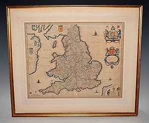
AN ORIGINAL ENGRAVED MAP OF Anglia regnum. Copper engraved map of the Kingdom of England
Published by Atlas Novus Ca 1642, 1642
Seller: PROCTOR / THE ANTIQUE MAP & BOOKSHOP, DORCHESTER, United Kingdom
Association Member: PBFA
Seller rating 5 out of 5 stars
Map
Lg.map (engr.surface 20.5 x 16 inches). In ivory mount. An attractive and decorative map in very good condition. Mount a little tanned. Nicely Original hand-coloured. Jan Jansson Jr (1588-1664), or Johannes Janssonius, was the son of a bookseller and publisher who had worked with Jodocus Hondius Sr. From about 1633 onwards, his imprint appears on the title-pages of the Mercator-Hondius "Atlas", in conjunction with his brother-in-law, Henry, as they re-issued their "Atlas" in competition with the Blaeus.
-

Vienna - Austriae. WIEN in Oostenreyk.
Published by (1657):, 1657
Seller: Harteveld Rare Books Ltd., Fribourg, Switzerland
Association Member: ILAB VEBUKU
Seller rating 4 out of 5 stars

39x50 cm (view) 41.5x52 cm (lichtmass) vue � vol d?oiseau, colori�e � la main d?�poque, pli au milieu avec l�g�res traces, / fine handcolored view, light wear on middle fold, sous passepartout dans un cadre or. 56x65 cm (cadre) / framed. Please notify before visiting to see a book. Prices are excl. VAT/TVA (only Switzerland) & postage. Striking early view of Vienna from the east side of the Danube River, published by Jansson in 1657.Includes a key locating 42 points of interest on the map.The map is based upon the view of Vienna which appeared in Braun & Hogenberg'sCivitates Orbis Terrarum.