Order Total (1 Item Items):
Shipping Destination:

Guillaume Delisle L'isle (30 results)
Skip to main search results
Product Type
- All Product Types
- Books (12)
- Magazines & Periodicals
- Comics
- Sheet Music
- Art, Prints & Posters (1)
- Photographs
- Maps (17)
-
Manuscripts &
Paper Collectibles
Condition
- All Conditions
- New
- Used
Binding
- All Bindings
- Hardcover
- Softcover (2)
Collectible Attributes
- First Edition (4)
- Signed
- Dust Jacket
- Seller-Supplied Images (24)
- Not Printed On Demand
Seller Location
Seller Rating
-
Carte du B�arn de La Bigorre de l'Armagnac et des Pays Voisins. Kupferstichkarte mit Fl�chenkolorit.
Published by A Paris, De L'Isle, 1712
Map
Condition: Gut. 48 x 63 cm (Blattgr��e: 54,5 x 81 cm). *Fr�he Delisle-Karte, zeigt einen Teil des franz�sischen Westens. Die Provinzen mit Fl�chenkolorit, davon eine im Westen von Hand im Kolorit �ber den Plattenrand hinaus konturiert und koloriert. - Guillaume Delisle (1675-1726) war ein franz�sischer Kartograph aus Paris. Delisle war der erste, der eine wissenschaftlich vergleichende Geographie anbahnte, indem er bei seinen Werken auch Reiseberichte und die Werke von Naturforschern benutzte. Er gab zahlreiche Landkarten heraus, die sich durch Eleganz und Sch�rfe von den fr�heren Karten unterschieden. - Gut erhalten. / Early print of this Delisle map. Good condition. Sprache: Deutsch Gewicht in Gramm: 1000.
-
Carte de la Beau ce du Gatinois de la Sologne et Pays voisin dans la Generalit� d'Orleans. Kupferstichkarte mit Grenzkolorit.
Published by A Paris, De L'Isle, 1716
Map
Condition: Gut. 49,5 x 62 cm (Blattgr��e: 54,5 x 81 cm). *Fr�he Delisle-Karte, zeigt das Gebiet um die Loire, im Zentrum die Stadt Orleans. - Guillaume Delisle (1675-1726) war ein franz�sischer Kartograph aus Paris. Delisle war der erste, der eine wissenschaftlich vergleichende Geographie anbahnte, indem er bei seinen Werken auch Reiseberichte und die Werke von Naturforschern benutzte. Er gab zahlreiche Landkarten heraus, die sich durch Eleganz und Sch�rfe von den fr�heren Karten unterschieden. - Der breite wei�e Rand wurde zeitgen�ssisch eigens aufmontiert, vermutlich wegen der enormen Blattgr��e. Sauber und gut erhalten. / Early print of this Delisle map. The large white edges were mounted separate in contemporarily time (probably because of the large sheet size). Very good condition. Sprache: Deutsch Gewicht in Gramm: 1000.
-

Carte de la Prevost� et Vicomt� de Paris Dress�e sur un grand nombre de Memoires particuliers. Kupferstichkarte.
Published by A Paris, De L'Isle, 1711
Map
Condition: Gut. 49,5 x 64 cm (Blattgr��e: 54,5 x 81 cm). *Fr�he Delisle-Karte, zeigt das Gebiet um Paris. Unkoloriert (nur die Stadt Paris ist rot markiert). - Guillaume Delisle (1675-1726) war ein franz�sischer Kartograph aus Paris. Delisle war der erste, der eine wissenschaftlich vergleichende Geographie anbahnte, indem er bei seinen Werken auch Reiseberichte und die Werke von Naturforschern benutzte. Er gab zahlreiche Landkarten heraus, die sich durch Eleganz und Sch�rfe von den fr�heren Karten unterschieden. - Der breite wei�e Rand wurde zeitgen�ssisch eigens aufmontiert. Sauber und sehr gut erhalten. / Early print of this Delisle map. The large white edges were mounted separate in contemporarily time. Good condition. Sprache: Deutsch Gewicht in Gramm: 1000.
-
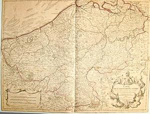
Condition: Gut. 48 x 60 cm (Blattgr��e: 54,5 x 81 cm). *Fr�he Delisle-Karte, zeigt den Nordosten von Frankreich s�dlich Calais mit dem �stlich angrenzenden Gebiet von Belgien. - Guillaume Delisle (1675-1726) war ein franz�sischer Kartograph aus Paris. Delisle war der erste, der eine wissenschaftlich vergleichende Geographie anbahnte, indem er bei seinen Werken auch Reiseberichte und die Werke von Naturforschern benutzte. Er gab zahlreiche Landkarten heraus, die sich durch Eleganz und Sch�rfe von den fr�heren Karten unterschieden. - Der breite wei�e Rand wurde zeitgen�ssisch eigens aufmontiert, vermutlich wegen der enormen Blattgr��e. Sauber und gut erhalten. / Early print of this Delisle map. The large white edges were mounted separate in contemporarily time (probably because of the large sheet size). Very good condition. Sprache: Deutsch Gewicht in Gramm: 1000.
-
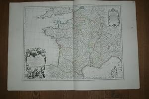
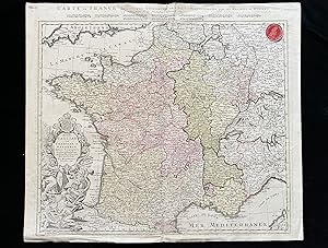
Carte de France. Dress�e pour l'usage du Roy. Teilkolorierte Kupferstichkarte.
Published by A Paris, De L'Isle, 1721
Map
Condition: Gut. 48,5 x 62 cm (Blattgr��e: 54,5 x 80 cm). *Fr�he Delisle-Karte, zeigt detailliert das gesamte Frankreich. Bereits 1703 war eine erste Frankreichkarte von Delisle erschienen, die vorliegende wurde neu gefertigt in ver�nderter Form und etwas kleinerem Ma�stab (also in gr��erer Darstellung). Titelkartusche unten links. - Guillaume Delisle (1675-1726) war ein franz�sischer Kartograph aus Paris. Delisle war der erste, der eine wissenschaftlich vergleichende Geographie anbahnte, indem er bei seinen Werken auch Reiseberichte und die Werke von Naturforschern benutzte. Er gab zahlreiche Landkarten heraus, die sich durch Eleganz und Sch�rfe von den fr�heren Karten unterschieden. - Sauber und sehr gut erhalten. / Early print of this Delisle map. Good condition. Sprache: Deutsch Gewicht in Gramm: 1000.
-
Carte Particuli�re d'Anjou et de Touraine ou de la Partie Meridionale de la Generalite de Tours. Teilkolorierte Kupferstichkarte.
Published by A Paris, De L'Isle, 1720
Map
Condition: Gut. 48,5 x 66 cm (Blattgr��e: 54,5 x 81 cm). *Fr�he Delisle-Karte, zeigt detailliert das Flussgebiet des Anjou s�dlich Tours in der Bretagne. - Guillaume Delisle (1675-1726) war ein franz�sischer Kartograph aus Paris. Delisle war der erste, der eine wissenschaftlich vergleichende Geographie anbahnte, indem er bei seinen Werken auch Reiseberichte und die Werke von Naturforschern benutzte. Er gab zahlreiche Landkarten heraus, die sich durch Eleganz und Sch�rfe von den fr�heren Karten unterschieden. - Der breite wei�e Rand wurde zeitgen�ssisch eigens aufmontiert. Sauber und sehr gut erhalten. / Early print of this Delisle map. The large white edges were mounted separate in contemporarily time. Good condition. Sprache: Deutsch Gewicht in Gramm: 1000.
-
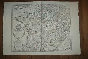
La France. Dress�e sur un grand nombre de Cartes particulieres manuscrites ou imprim�e lev�es sur les lieux. Teilkolorierte Kupferstichkarte.
Published by A Paris, De L'Isle, 1703
Map
Condition: Gut. 49 x 67 cm (Blattgr��e: 54,5 x 81 cm). *Fr�he Delisle-Karte, zeigt detailliert das gesamte Frankreich. Gro�e Titelkartusche unten links. - Guillaume Delisle (1675-1726) war ein franz�sischer Kartograph aus Paris. Delisle war der erste, der eine wissenschaftlich vergleichende Geographie anbahnte, indem er bei seinen Werken auch Reiseberichte und die Werke von Naturforschern benutzte. Er gab zahlreiche Landkarten heraus, die sich durch Eleganz und Sch�rfe von den fr�heren Karten unterschieden. - Der breite wei�e Rand wurde zeitgen�ssisch eigens aufmontiert. Linker Au�enrand mit kleinem Tintenfleckchen, insgesamt sauber und gut erhalten. / Early print of this Delisle map. The large white edges were mounted separate in contemporarily time. Good condition. Sprache: Deutsch Gewicht in Gramm: 1000.
-
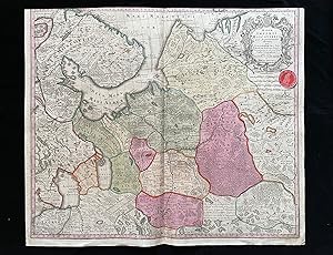
Carte du Bourdelois, du Perigord et des Provinces voisines. Teilkolorierte Kupferstichkarte mit Grenz- und Fl�chenkolorit.
Published by A Paris, De L'Isle, 1714
Map
Condition: Gut. 71 x 64 cm (Blattgr��e: 76 x 80,5 cm). *Fr�he Delisle-Karte, eine zweite (gr��ere) Variante unter diesem Titel (und in gleichem Ma�stab). Sie ist gr��er als die andere Karte (nochmals aufgeklappt) und enth�lt den gesamten S�dwesten Frankreichs. Die Karte zeigt das Gebiet des Bordeaux Weines und Perigord mit den Flu�gebiet der Garonne und reicht s�dlich bis zur Spanischen Grenze. Es sind die St�dte Bordeaux (im n�rdl. Teil) sowie Bayonne und Toulouse im s�dlichen Teil bis an die Pyren�en enthalten. - Guillaume Delisle (1675-1726) war ein franz�sischer Kartograph aus Paris. Delisle war der erste, der eine wissenschaftlich vergleichende Geographie anbahnte, indem er bei seinen Werken auch Reiseberichte und die Werke von Naturforschern benutzte. Er gab zahlreiche Landkarten heraus, die sich durch Eleganz und Sch�rfe von den fr�heren Karten unterschieden. - Der breite wei�e Rand wurde zeitgen�ssisch eigens aufmontiert. Im Mittelfalz unten mit Einri� im wei�en Rand. Seitliche R�nder mit Altersbr�unung. Insgesamt gut erhalten. / Early print of this Delisle map. The large white edges were mounted separate in contemporarily time. A small tear in outline margin, altogether in good condition. Sprache: Deutsch Gewicht in Gramm: 1000.
-

P, Dezauche , 1780 , carte 66 x 51 cm Contours des provinces colori�es � l' �poque, mouillure claire sur la partie inf�rieure. Langue: Fran�ais Livres.
-
P, Dezauche , 1780 , carte 66 x 49 cm Contours des provinces colori�es � l' �poque, restauration discr�te � la pliure petits manques de papier dans les coins. Livres.
-
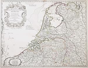
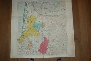
Carte des Provinces Unies des Pays Bas" - Holland Nederland Netherlands Niederlande Holland Nederland Netherlands Niederlande Pays Bas
Published by Paris, Buache, 1762
Seller: Antiquariat Steffen V�lkel GmbH, Seubersdorf, Germany
Seller Rating:

Map
Blatt-Masse ca. 52 x 70 cm. -- Altkolorierte Kupferstich-Karte. Original old colored etched map. - Zeigt das Gebiet von den Niederlanden und Teilen von Belgien. -- am oberen Au�enrand teils etwas fleckig - sonst gut erhalten. || Dies ist ein Original! - Kein Nachdruck! - Keine Kopie! -- This is an original! - No copy! - No reprint! Sprache: Franz�sisch Gewicht in Gramm: 30.
-
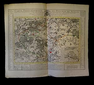
A Amsterdam, chez J. Covens et C. Mortier, s.d. [1745]. Dimensions : 668 x 563 mm. Importante carte grav�e avec rehauts aquarell�s figurant - outre un plan particulier de la ville de Senlis et de Crespy [sic], des villages tels : Le Plessis Belleville, Dammartin, Lusarche, Creil ou encore Cr�py en Valois. ''La carte est entour�e d'une table alphab�tique des lieux du Dioc�se de Senlis et, sous la carte, d'un "avertissement" et d'une "explication des marques" en fran�ais et en n�erlandais''. Pliure centrale. Infime tout autant que discr�te aur�ole en marge droite. Du reste, tr�s belle condition.
-
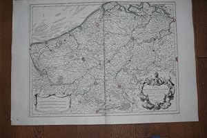
Carte du Comte de Flandre. Dress�e sur differens morceaux levez sur les lieux fix�z par les Observations Astronomiques. Altkolorierte Kupferstichkarte.
Published by A Paris, chez l'Auteur sur de Quai de l'Horloge, 1704
Map
Condition: Gut. 48,5 x 65 cm (Blattgr��e ca. 54,5 x 80 cm). *Fr�he Delisle-Karte, zeigt Belgien. - Guillaume Delisle (1675-1726) war ein franz�sischer Kartograph aus Paris. Delisle war der erste, der eine wissenschaftlich vergleichende Geographie anbahnte, indem er bei seinen Werken auch Reiseberichte und die Werke von Naturforschern benutzte. Er gab zahlreiche Landkarten heraus, die sich durch Eleganz und Sch�rfe von den fr�heren Karten unterschieden. - Der breite wei�e Rand wurde zeitgen�ssisch eigens aufmontiert, vermutlich wegen der enormen Blattgr��e. Sauber und gut erhalten. / Early print of this Delisle map. The large white edges were mounted separate in contemporarily time (probably because of the enormous sheet size). Very good condition. Sprache: Deutsch Gewicht in Gramm: 1000.
-
Partie Septentrionale De La Souabe. Par Guillaume De l'Isle Geographe de L'Academie Royale des Sciences. Altkolorierte Kupferstichkarte.
Published by A Paris, chez l'Auteur sur de Quai de l'Horloge et a Amsterdam, chez Louis Renard, 1704
Map
Condition: Gut. 47,5 x 63,5 cm (Blattgr��e: 55 x 81 cm). *Fr�he Delisle-Karte, zeigt das nordwestliche W�rttemberg und Mittelfranken von Stuttgart bis N�rnberg in der West-Ost-Erstreckung und von Winsheim bis G�ppingen in der Nord-S�d-Erstreckung. - Guillaume Delisle (1675-1726) war ein franz�sischer Kartograph aus Paris. Delisle war der erste, der eine wissenschaftlich vergleichende Geographie anbahnte, indem er bei seinen Werken auch Reiseberichte und die Werke von Naturforschern benutzte. Er gab zahlreiche Landkarten heraus, die sich durch Eleganz und Sch�rfe von den fr�heren Karten unterschieden. - Der breite wei�e Rand wurde zeitgen�ssisch eigens aufmontiert, vermutlich wegen der enormen Blattgr��e. Sauber und gut erhalten. / Early print of this Delisle map. The large white edges were mounted separate in contemporarily time (probably because of the enormous sheet size). Very good condition. Sprache: Deutsch Gewicht in Gramm: 1000.
-
1780 Paris, Dezauche , 1780 , carte 63 x 48 cm . Limites des provinces colori�es , 2 jolis cartouches . L�g�re brunissure au centre inf�rieur . Langue: Fran�ais Livres.
-
Paris , Dezauche, 1772 , carte 63 x 48 cm limites color�es , cartouche d�coratif , quelques petites taches d' encre.Photo sur demande Langue: Fran�ais Livres.
-
Condition: Gut. Gut. Kupferstich, altkoloriert. Blattgr��e: 53,5 x 62 cm, Druckspiegel: 52,3 x 57,8 cm. . Sch�ner und kr�ftiger Druck auf etwas gebr�untem Papier, an den R�ndern leichte Knickspuren, ansonsten gut erhalten. Gro�e altkolorierte Landkarte Frankreichs nach dem franz�sischen Kartographen Guillaume Delisle (1675-1726), mit Lothringen und Elsa� sowie Teilen von Deutschland (Westphalen, Rheinland, Pfalz, Saarland, W�rttemberg, Schwaben, Baden), Schweiz, Savoyen und Italien. Mit heraldischer Kartusche "Regni Galliae seu Franciae et Navarrae Tabula Geographica". Landkarte, map, carte g�ographique, carta geografica, Frankreich, France, Francia. 1800 Gramm.
-
Mappa Imperii Moscovitici pars septentrionalis. Landkarte des Moskauer Reiches, n�rdlicher Teil.
Published by Matth�us Seutter um 1730, Augsburg, 1730
Map
Condition: Gut. Gut. Kupferstich, altkoloriert. Blattgr��e: 51 x 60,3 cm, Druckspiegel: 49,8 x 58,3 cm. . Sch�ner und kr�ftiger Druck auf etwas gebr�untem Papier, oben knapp beschnitten (geringer Verlust der L�ngengradskala), Falz unten verso hinterlegt, ansonsten gut erhalten. Gro�e Karte von Nordwestrussland (______-________ ___________ _____, Sewero-sapadny federalny okrug) mit seiner Hauptstadt St. Petersburg ganz im S�dwesten, als Teil des Russischen Zarenreiches (_______ _______, Russkoje zarstwo, Gro�f�rstentum Moskau, Moskowien, Muskowien, _______ _________ __________, Velikoe Knja_estvo Moskovskoe). Mit sch�ner Kartusche samt dem Wappen des Zarenreiches Russland. Landkarte, map, carte g�ographique, carta geografica, Zarenreich Russland, Russisches Kaiserreich, Tsardom of Russia, Tsarat de Russie, Regno russo, Northwestern, Nord-Ouest, nordoccidentale. 1800 Gramm.
-
Carte du Comt� de Flandres dress�e sur differens morceaux levez sur les lieux fix�z par les Observations Astronomiques.
Published by Guillaume De l'Isle, 1704
Map
souple. carte au format 645 x 49 cm., fronti�res rehauss�e en couleur, par Guillaume De l'Isle, de l'Acad�mie Royale des Sciences � Paris, Chez l'Auteur sur le Quai de l'Horloge, 1704 Etat satisfaisant (marges rogn�es au maximum, petites salissures). Langue: Fran�ais.
-
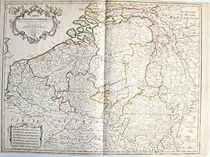
Carte des Pays Bas Catholiques dress�e sur un grand nombre de cartes particuli�res faites sur les lieux o� les limites sont exactement marqu�es, suivant les derniers Trait�z
Published by Chez l'Auteur sur le Quai de l'Horloge, 1702
Map
souple. Carte au format 66 x 48 cm, fronti�res rehauss�e en couleur, par Guillaume De l'Isle, de l'Acad�mie Royale des Sciences � Paris, Chez l'Auteur sur le Quai de l'Horloge, 1702 Bon �tat (3 tr�s petites taches d'encre) pour cette belle carte �tablie et imprim�e par Delisle. Langue: Fran�ais.
-
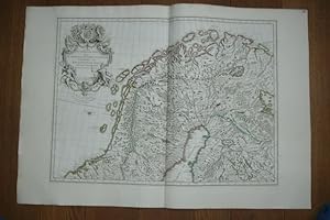
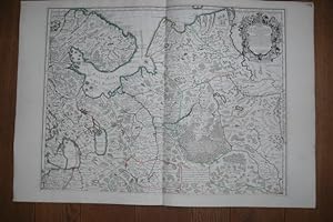
Carte des couronnes du Nord. Dedie au tres Puissant et tres Invincible Prince Charles XII, Roy de Suede, des Gots et des Vandales, Grand Duc de Finlande &c. Altkolorierte Kupferstichkarte.
Published by A Paris, chez l'Auteur sur de Quai de l'Horloge et a Amsterdam, chez Louis Renard, 1706
Map
Condition: Gut. 45 x 62 cm (Blattgr��e ca. 55 x 80 cm). *Fr�he Delisle-Karte, zeigt das n�rdliche Finnland, Schweden und Norwegen. - Guillaume Delisle (1675-1726) war ein franz�sischer Kartograph aus Paris. Delisle war der erste, der eine wissenschaftlich vergleichende Geographie anbahnte, indem er bei seinen Werken auch Reiseberichte und die Werke von Naturforschern benutzte. Er gab zahlreiche Landkarten heraus, die sich durch Eleganz und Sch�rfe von den fr�heren Karten unterschieden. - Der breite wei�e Rand wurde zeitgen�ssisch eigens aufmontiert, vermutlich wegen der enormen Blattgr��e. Sauber und gut erhalten. / Early print of this Delisle map. The large white edges were mounted separate in contemporarily time (probably because of the enormous sheet size). Very good condition. Sprache: Deutsch Gewicht in Gramm: 1000.
-
Carte de Moscovie. N�rdlicher und s�dlicher Teil in 2 Karten auf 2 Blatt. Zwei Kupferstichkarten mit Grenzkolorit.
Published by Paris, De L'Isle ca. 1706., 1706
Map
Condition: Gut. 49,5 x 65 und 50 x 65 cm (Blattgr��e je: 54,5 x 81 cm). *Fr�he Delisle-Karte des Moskauer Gebietes, gestochen auf zwei gro�en Karten. Die n�rdliche Karte enth�lt die Titelkartusche oben rechts, die s�dliche Karte ohne Titel. Wohl die fr�heste von etlichen Moskau-Karten Delisles. - Guillaume Delisle (1675-1726) war ein franz�sischer Kartograph aus Paris. Delisle war der erste, der eine wissenschaftlich vergleichende Geographie anbahnte, indem er bei seinen Werken auch Reiseberichte und die Werke von Naturforschern benutzte. Er gab zahlreiche Landkarten heraus, die sich durch Eleganz und Sch�rfe von den fr�heren Karten unterschieden. - Der breite wei�e Rand wurde zeitgen�ssisch eigens aufmontiert, vermutlich wegen der enormen Blattgr��e. Sauber und gut erhalten. / Early print of this Delisle maps. The large white edges were mounted on both maps separate in contemporarily time (probably because of the large sheet size). Very good condition. Sprache: Deutsch Gewicht in Gramm: 1000.
-
![Seller image for Carte d'Europe dress�e pour l'usage du Roy [sic] sur les itin�raires anciens et modernes et sur les routiers de mer assujettis aux observations astronomiques. for sale by Babel Librairie](https://pictures.abebooks.com/inventory/md/md30510098372.jpg)
A Paris, chez l'auteur, 1745. Dimensions : 618 x 498 (cuvette) + passe-partout + cadre. Grande et belle carte r�alis�e sur verg� fort avec rehauts aquarell�es du temps. Outre une repr�sentation g�n�rale de l'Europe, la carte faite appara�tre la Russie et la Turquie ainsi qu'une partie de la Syrie et de l'Arabie. ''El�ve de Cassini, Delisle publie en 1700 ses premi�res cartes, la Carte du monde et la Carte des continents, qui contribuent � �tablir sa renomm�e. Il introduit en cartographie le recours aux donn�es astronomiques. Quand l'astronomie reste muette, il compulse toutes les cartes et tous les livres de voyage qu'il peut trouver. Sur les points disput�s, il cite sa source sur la carte ou r�dige des notes additionnelles pour l'Acad�mie des sciences''. Pliure centrale. Quelques claires rousseurs �parses (davantage marqu�es sur le passe-partout).
-
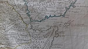
Carte de l'Egypte, de la Nubie, de l'Abissinie &c par Guillaume De lisle de l'Academie R. des Sciences (antique map of Egypt, Nubia, Abyssinia, etc.)
Published by Dezauche, Paris, 1780
First Edition
A stunning map of Arabia and northeastern Africa (from Libya and Egypt in the north to Somalia and the Gulf of Guinea in the south). 50 x 62 cm (plate), 55 x 76 cm (sheet). Arabia, Egypt, Sudan, and Abyssinia (Ethiopia) are wonderfully detailed; the interior much less so, with some marvelously cryptic comments ("Desert de Berdoa, d'une grande s�cheresse, o� il n'y a pas de s�ret� pour les marchands � cause de voleurs"; "Royaume de T�mian, dont les habitans sont � ce qu'on dit Antropophages.") Printed on fine, thick watermarked laid paper. Original outline color. Reverse blank. A fine impression. Three small faint stains in the upper margin that could easily be removed, and that in any case would be invisible were the map matted and framed), else A PRISTINE EXAMPLE, with the paper FINE AND BRIGHT. Very scarce in such fine condition.
-
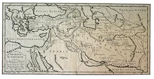
Imperium Assyriorum
Published by n.p., n.p., 1728
Seller: Kaaterskill Books, ABAA/ILAB, East Jewett, NY, U.S.A.
Association Member: ABAA ILAB IOBA
Seller Rating:
Image: 223 x 456 mm. Guillaume Delisle (1675-1726) was a French cartographer who added to the accuracy of mapmaking by incorporating the discoveries of French astronomers in his work. Imperium Assyriorum was engraved by Jean-Baptiste Delahaye and published posthumously in 1728. Scarce. We have only found copies in the Biblioteque National. A very good copy, trimmed close but not touching borders, mounted on a 520 x 720 mm sheet with a few minor chips, and tear along fold, all well away from image.
-
A BEAUTIFUL MAP OF HUNGARY AND THE BALKANS, from the Gulf of Venice to the Black Sea. 47 x 65 cm (plate), 54 x 80 cm (sheet). ORIGINAL OUTLINE COLOR. Printed on fine, thick laid paper. Reverse blank. A fine impression. A PRISTINE EXAMPLE, with the paper FINE AND BRIGHT. Very scarce in such fine condition.
-
Carte de la Champagne et des Pays Voisins o� l'on voit la Generalit� de Chalons, partie de celle de Soissons, &c. Par Guillaime De L'Isle de l'Acad�mie Royale des Sciences. (antique map of Champagne)
Published by J. Covens et C. Mortier, Amsterdam, 1742
First Edition
A BEAUTIFUL HAND-COLORED MAP OF CHAMPAGNE and nearby areas. 48 x 63 cm (plate), 56 x 69 cm (sheet). The areas described in the title are FULLY COLORED BY A CONTEMPORARY HAND. Printed on fine, thick laid paper. Reverse blank. A fine impression. A few tiny marginal tears, else A PRISTINE EXAMPLE, with the paper FINE AND BRIGHT. Very scarce in such fine condition.
-
[MAP / THE BLACK SEA / CRIMEA / UKRAINE / EASTERN EUROPE] Nouvelle Carte de la Petite Tartarie et la Mer Noire, montrant les Frontieres de l'Imp�ratrice de Russie et de l'Empereur des Turcs, tant en Europe qu'en Asie, Dessign� selon la proposition de G. De L'Isle et d'autres Auteurs. Carl Christian Franz Radefeld, (1788-1874).
Published by Chez Elwe & Langeveld / Renier & Ioshua Ottens, Amsterdam
Seller: Khalkedon Rare Books, IOBA, Istanbul, Turkey
Seller Rating:

Book First Edition
No Binding. Condition: Very Good. 1st Edition. An 18th-century hand-colored copper engraved map of Ukraine and the Black Sea in a fine impression with original hand-coloring in its period. 52x62 cm. In French. Scale: 1/2750000. Slight stains on the upper margin. Faded on paper. Otherwise a very good map. Rare in original color showing the Black Sea and its surroundings, of the little Tartary and the Black Sea of Delisle republished by Renier and Joshua Ottens. Can be seen on the map, Moldavia, Bulgaria, Natolia, Little Tartarie, Ukraine, and Crimea with contiguous regions and hinterland. In the century when this map was prepared (18th century), firstly, the territory of Crimea was controlled by the Crimean Khanate, then it was annexed by the Russian Empire on 19 April [O.S. 8 April] 1783. The period before the annexation was marked by Russian interference in Crimean affairs, a series of revolts by Crimean Tatars, and Ottoman ambivalence. The annexation began 134 years of rule by the Russian Empire, which ended with the Russian Revolution of 1917. Guillaume Delisle was a French cartographer known for his popular and accurate maps of Europe and the newly explored Americas. At 27, Delisle was admitted into the French Acad�mie Royale des Sciences, an institution financed by the French state. After that date, he signed his maps with the title of "G�ographe de l'Acad�mie". Five years later, he moved to the Quai de l?Horloge in Paris, a true publishing hub where his business prospered. Delisle's progress culminated in 1718 when he received the title of Premier G�ographe du Roi. He was appointed to teach geography to the Dauphin, King Louis XIV's son, a task for which he received a salary. Again, his father's reputation as a man of science probably helped the younger Delisle. In Delisle's case, it could be said that his accomplishments surpassed his father's. Up to that point, he had drawn maps not only of European countries, such as Italy, Spain, Germany, Great Britain, and Poland, and regions such as the Duchy of Burgundy, but he had also contributed to the empire's claims to recently explored continents of Africa and the Americas. Publisher: Jan Barend Elwe (177-1815), was a Dutch publisher and bookseller who reissued maps by De l'Isle and Ottens and some other cartographers in the late 18th century. His famous map "Amerique Septentrionale Divisee en ses Principales Parties" was derived mainly from Sanson's and Jaillot's maps of 1656 and 1676. This map was published in 1792 in an Atlas which included 37 other maps of different countries and regions.
-
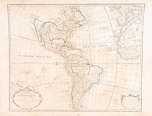
Carte d'Amerique, dress�e pour l'usage du Roy. Par Guillaume Delisle premier G�ographe de Sa Majest� de l'Academie Royale des Sciences. First Edition.
Published by Paris: Chez l'Auteur, 1722
Art / Print / Poster
Condition: Good. Copper-engraved map, hand-colored in outline. 48.5 x 59.9 cm. (19 x 23�"). Matted, overall 25� x 29�". OCLC Number: 51213464 (for the later Buache edition)Second state of De l'Isle's important and highly influential map of North and South America, with the plain lettering of the word "d'Amerique" in the title, though on this example there are fairly clear impressions on the longitudinal lines, which tended to deteriorate in the second state. For California, the west coast is taken north to Cap Mendocin and Cap Blanc, with the notation, "Entr�e decouverte par Martin d'Aguilar." Wagner notes "Briggs names with some of the corrections made by Blaeu. The Mediterranean Sea of California has disappeared. Delisle retained Cabrillo's B. de Pinos and introduced a few, the I. Ste Anne, the B. de St. Martin, and the B. de la Medelaine, from other maps. It seems likely that he had read the account of the Vizcaino expedition Torquemada. On the Sonora coast the names are much the same as those on his 1700 map with a few additions from Kino's map and other sources in Sonora." Like many of De l'Isle's maps, this one had a long life, as Tooley notes, "His map of America of 1722 was republished until 1830, revised in places but basically unchanged." Portinaro & Knirsh Plate 114; Tooley p.13, #1, & Plate 1 state); Wagner NW Coast 523.
-
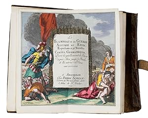
Le flambeau de la guerre allumee au Rhin; representee en 36 nouvelles cartes geographiques, = De fakkel des oorlogs ontstoken aan den Rhyn; verbeeld in 36 nieuwe geographische landkaarten, Amsterdam, Petrus Schenk II, 1735. 8vo. With a double-page engraved title, two double-page engraved pages of text in Dutch and French, a folding engraved map and 36 double-page engraved maps; all coloured by hand. Original publisher's red sheepskin with a flap and wrapping band.
Seller: ASHER Rare Books, T Goy Houten, Netherlands
Seller Rating:
Very rare pocket atlas of the Rhine-area between Cologne in the north and Basel, published for use by military officers and civilian travellers and based on maps prepared by Guillaume de l'Isle (1675-1725) during the War of the Spanish Succession (1701-1714). A folding map shows the entire region and identifies the separate maps. The publisher promises in the introduction that all 36 maps combined will result in a "very large map": ca. 140 x 65 cm.The present pocket atlas, marketed for travellers, was sold ready bound and coloured, as opposed to the common practice of selling books in loose sheets. Schenk published a second edition in 1744 with several corrections and an extra map.The British Captain George Howard (1718-1796) bought the present copy on 10 August 1743, probably at the bookshop of Philipp Heinrich Hutter in Frankfurt. Howard served in the 3rd regiment of foot ("The Buffs") under his father Thomas Howard and had just participated in the Battle of Dettingen (May 1743) during the War of the Austrian Succession (1740-1748) when he bought this atlas. He would later command the Buffs at the Battle of Fontenoy (1745) and at Falkirk Muir and Culloden (1746). After the wars he became an MP and was ultimately promoted to Field Marshal in 1793. Loosely inserted in a pocket of the atlas is a note in Howard's hand describing on one side the affairs on 10-13 August 1743 and on the other side his expenses in July and August 1743. The pocket atlas is probably noted as "a book of maps" on 11 August.With the owner's inscription of George Howard on the paste-down and a leaf containing notes in his hand loosely inserted in the front pocket. A later slip of paper containing a manuscript title and shelfmarks is mounted on the back board. Headbands slightly worn, otherwise in very good condition.l Koeman III, Sche 10; Maandelyke uitreksels; of Boekzaal der geleerde waerelt XL (April 1735), pp. 484-485; STCN (1 copy), WorldCat (5 copies).

![Seller image for [MAP / THE BLACK SEA / CRIMEA / UKRAINE / EASTERN EUROPE] Nouvelle Carte de la Petite Tartarie et la Mer Noire, montrant les Frontieres de l'Imp�ratrice de Russie et de l'Empereur des Turcs, tant en Europe qu'en Asie, Dessign� selon la proposition de G. De L'Isle et d'autres Auteurs. Carl Christian Franz Radefeld, (1788-1874). for sale by Khalkedon Rare Books, IOBA](https://pictures.abebooks.com/inventory/md/md31312970800.jpg)