Order Total (1 Item Items):
Shipping Destination:

Guillaume Delisle (309 results)
Skip to main search results
Product Type
- All Product Types
- Books (124)
- Magazines & Periodicals
- Comics
- Sheet Music
- Art, Prints & Posters (8)
- Photographs
- Maps (175)
-
Manuscripts &
Paper Collectibles (2)
Condition
Binding
Collectible Attributes
- First Edition (6)
- Signed
- Dust Jacket
- Seller-Supplied Images (285)
- Not Printed On Demand (303)
Free Shipping
Seller Location
Seller Rating
-
Fun?railles de M. le comte Henri Delaborde, secr?taire perp?tuel honoraire
Published by Hachette Livre Bnf, 2021
ISBN 10: 2329657447ISBN 13: 9782329657448
Book Print on Demand
PAP. Condition: New. New Book. Shipped from UK. THIS BOOK IS PRINTED ON DEMAND. Established seller since 2000.
More buying choices from other sellers on AbeBooks
New offers from � 16.71
-

Remarques Sur Le Th��tre Historique Pour l'An 400 de l'�re Chr�tienne (Histoire) (French Edition)
Published by Hachette Livre Bnf, 2015
ISBN 10: 2011905303ISBN 13: 9782011905307
Book
Condition: New.
More buying choices from other sellers on AbeBooks
New offers from � 18.87
-
Remarques Sur Le Th��tre Historique Pour l'An 400 de l'�re Chr�tienne (Histoire) (French Edition)
Published by Hachette Livre Bnf, 2015
ISBN 10: 2011906008ISBN 13: 9782011906007
Book
Condition: New.
More buying choices from other sellers on AbeBooks
New offers from � 18.87
-
Introduction a la Geographie. Sph�re (French Edition)
Published by Hachette Livre Bnf, 2021
ISBN 10: 2329598157ISBN 13: 9782329598154
Book
Condition: New.
More buying choices from other sellers on AbeBooks
New offers from � 22.05
-
![Seller image for Sylva observationum linguae latinae, Gulielmo Insulano Menapio Grevibrocensi autore. Ejusdem Oratio funebris in obitum D. Erasmi Roterodami, recognita & aucta. 1533 [LeatherBound] for sale by True World of Books](https://pictures.abebooks.com/inventory/md/md31616436459.jpg)
LeatherBound. Condition: New. LeatherBound edition. Condition: New. Reprinted from edition. Leather Binding on Spine and Corners with Golden leaf printing on spine. Bound in genuine leather with Satin ribbon page markers and Spine with raised gilt bands. A perfect gift for your loved ones. NO changes have been made to the original text. This is NOT a retyped or an ocr'd reprint. Illustrations, Index, if any, are included in black and white. Each page is checked manually before printing. As this print on demand book is reprinted from a very old book, there could be some missing or flawed pages, but we always try to make the book as complete as possible. Fold-outs, if any, are not part of the book. If the original book was published in multiple volumes then this reprint is of only one volume, not the whole set. Sewing binding for longer life, where the book block is actually sewn (smythe sewn/section sewn) with thread before binding which results in a more durable type of binding. Pages: 175.
-
![Seller image for Catalogue des manuscrits des fonds Libri et Barrois [LeatherBound] for sale by True World of Books](https://pictures.abebooks.com/inventory/md/md31534505641.jpg)
Catalogue des manuscrits des fonds Libri et Barrois [LeatherBound]
Publication Date: 2023
Book Print on Demand
LeatherBound. Condition: New. LeatherBound edition. Condition: New. Reprinted from 1888 edition. Leather Binding on Spine and Corners with Golden leaf printing on spine. Bound in genuine leather with Satin ribbon page markers and Spine with raised gilt bands. A perfect gift for your loved ones. NO changes have been made to the original text. This is NOT a retyped or an ocr'd reprint. Illustrations, Index, if any, are included in black and white. Each page is checked manually before printing. As this print on demand book is reprinted from a very old book, there could be some missing or flawed pages, but we always try to make the book as complete as possible. Fold-outs, if any, are not part of the book. If the original book was published in multiple volumes then this reprint is of only one volume, not the whole set. Sewing binding for longer life, where the book block is actually sewn (smythe sewn/section sewn) with thread before binding which results in a more durable type of binding. Pages: 483 Language: French.
-
Envoi rapide tr�s bonne tenue proche du neuf int�rieur tr�s frais. in8. 2007. Broch�. Tr�s bon �tat.
-
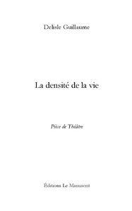
Paperback. Condition: NEUF. Beno�t et Sophie s'aiment.Beno�t et Sophie se d�chirent.Sophie retrouve Benoit.Beno�t pleure.Dans cette premi�re pi�ce de Guillaume Delisle, la consistance de l'amour est questionn�e et la densit� de la vie mise � nue � travers les moments les plus intimes d'un couple, de sa naissance � sa mort.Com�dien, metteur en sc�ne et auteur, Guillaume Delisle a la passion de la v�rit� des sentiments.Sans aucune concession faite au cynisme, il n'h�site jamais � heurter son lecteur pour mieux le r�veiller. - Nombre de page(s) : - Poids : 150g - Genre : Po�sie grand format.
-
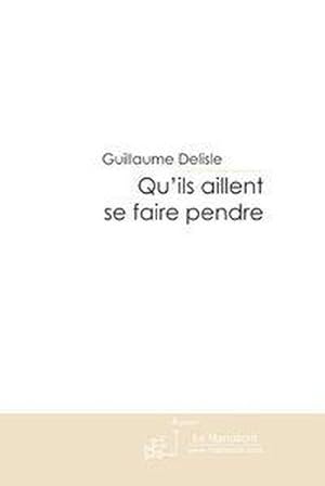
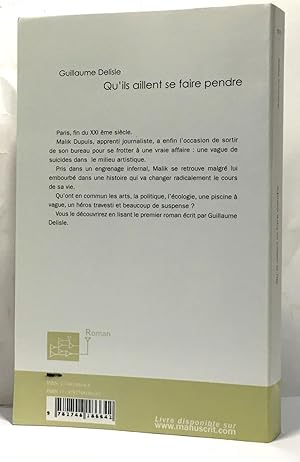
qu'ils aillent se faire pendre
Published by LE MANUSCRIT, 2007
ISBN 10: 2748186648ISBN 13: 9782748186642
Book
Paperback. Condition: NEUF. Paris, fin du XXI �me si�cle. Malik Dupuis, apprenti journaliste, a enfin l'occasion de sortir de son bureau pour se frotter � une vraie affaire : une vague de suicides dans le milieu artistique. Pris dans un engrenage infernal, Malik se retrouve malgr� lui embourb� dans une histoire qui va changer radicalement le cours de sa vie. Qu'ont en commun les arts, la politique, l'�cologie, une piscine � vague, un h�ros travesti et beaucoup de suspense. Vous le d�couvrirez en lisant le premier roman �crit par Guillaume Delisle. - Nombre de page(s) : - Poids : 570g - Genre : Science fiction / Fantastique grand format.
-
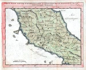
Carte de la Republique Romaine
Published by Delisle, Guillaume, Paris, 1700
"Carte . de la Republique Romaine". Orig. copperplate engraving. after G. Delisle map. Published in Paris, ca. 1700. Orig. old colouring. With title above the map. 14:17 cm (5 1/2 x 6 3/4 inch.). A map of the Central Italy. - Already at the beginning of the 18th century fitted to the thick paper.
-
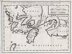
Carte des Isles Rhodienes" - Rhodos Griechenland Greece Archipelago island / Karte map carte plan
Published by Paris c. 1720., 1720
Seller: Antiquariat Steffen V�lkel GmbH, Seubersdorf, Germany
Seller Rating:

Map
Kupferstich-Karte von ca. 1720. Blatt-Ma�e: 25,5 x 35 cm. - sehr gut erhalten || Engraved map from ca. 1720. - in very good condition Sprache: Franz�sisch Gewicht in Gramm: 10.
-
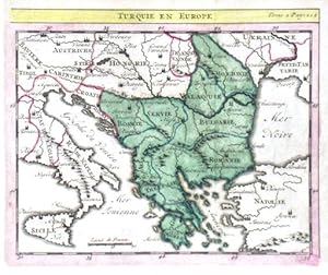
Turquie en Europe
Published by Delisle, Guillaume, Paris, 1700
"Turquie en Europe". Orig. copperplate engraving. after G. Delisle map. Published in Paris, ca. 1700. Orig. old colouring. With title above the map. 14:17 cm (5 1/2 x 6 3/4 inch.). A map of the Turkish possessions in Europe (Greece, Albania, Bosnia, Serbia, Croatia, Bulgaria, Romania, Moldova). - Already at the beginning of the 18th century fitted to the thick paper.
-
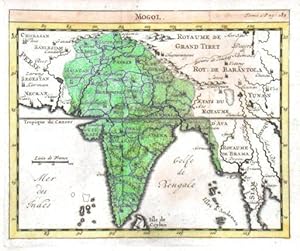
Mogol
Published by Delisle, Guillaume, Paris, 1700
India and Pakistan. "Mogol". Orig. copperplate engraving. after G. Delisle map. Published in Paris, ca. 1700. Orig. old colouring. With title above the map. 14:17 cm (5 1/2 x 6 3/4 inch.). A map of India and Pakistan. - Already at the beginning of the 18th century fitted to the thick paper.
-
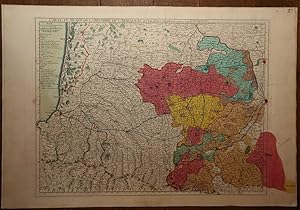
Carte du B�arn de La Bigorre de l'Armagnac et des Pays Voisins. Kupferstichkarte mit Fl�chenkolorit.
Published by A Paris, De L'Isle, 1712
Map
Condition: Gut. 48 x 63 cm (Blattgr��e: 54,5 x 81 cm). *Fr�he Delisle-Karte, zeigt einen Teil des franz�sischen Westens. Die Provinzen mit Fl�chenkolorit, davon eine im Westen von Hand im Kolorit �ber den Plattenrand hinaus konturiert und koloriert. - Guillaume Delisle (1675-1726) war ein franz�sischer Kartograph aus Paris. Delisle war der erste, der eine wissenschaftlich vergleichende Geographie anbahnte, indem er bei seinen Werken auch Reiseberichte und die Werke von Naturforschern benutzte. Er gab zahlreiche Landkarten heraus, die sich durch Eleganz und Sch�rfe von den fr�heren Karten unterschieden. - Gut erhalten. / Early print of this Delisle map. Good condition. Sprache: Deutsch Gewicht in Gramm: 1000.
-
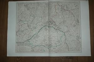
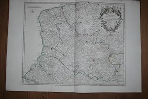
Carte de la Beau ce du Gatinois de la Sologne et Pays voisin dans la Generalit� d'Orleans. Kupferstichkarte mit Grenzkolorit.
Published by A Paris, De L'Isle, 1716
Map
Condition: Gut. 49,5 x 62 cm (Blattgr��e: 54,5 x 81 cm). *Fr�he Delisle-Karte, zeigt das Gebiet um die Loire, im Zentrum die Stadt Orleans. - Guillaume Delisle (1675-1726) war ein franz�sischer Kartograph aus Paris. Delisle war der erste, der eine wissenschaftlich vergleichende Geographie anbahnte, indem er bei seinen Werken auch Reiseberichte und die Werke von Naturforschern benutzte. Er gab zahlreiche Landkarten heraus, die sich durch Eleganz und Sch�rfe von den fr�heren Karten unterschieden. - Der breite wei�e Rand wurde zeitgen�ssisch eigens aufmontiert, vermutlich wegen der enormen Blattgr��e. Sauber und gut erhalten. / Early print of this Delisle map. The large white edges were mounted separate in contemporarily time (probably because of the large sheet size). Very good condition. Sprache: Deutsch Gewicht in Gramm: 1000.
-

Carte de la Prevost� et Vicomt� de Paris Dress�e sur un grand nombre de Memoires particuliers. Kupferstichkarte.
Published by A Paris, De L'Isle, 1711
Map
Condition: Gut. 49,5 x 64 cm (Blattgr��e: 54,5 x 81 cm). *Fr�he Delisle-Karte, zeigt das Gebiet um Paris. Unkoloriert (nur die Stadt Paris ist rot markiert). - Guillaume Delisle (1675-1726) war ein franz�sischer Kartograph aus Paris. Delisle war der erste, der eine wissenschaftlich vergleichende Geographie anbahnte, indem er bei seinen Werken auch Reiseberichte und die Werke von Naturforschern benutzte. Er gab zahlreiche Landkarten heraus, die sich durch Eleganz und Sch�rfe von den fr�heren Karten unterschieden. - Der breite wei�e Rand wurde zeitgen�ssisch eigens aufmontiert. Sauber und sehr gut erhalten. / Early print of this Delisle map. The large white edges were mounted separate in contemporarily time. Good condition. Sprache: Deutsch Gewicht in Gramm: 1000.
-
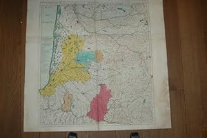
Condition: Gut. 48 x 60 cm (Blattgr��e: 54,5 x 81 cm). *Fr�he Delisle-Karte, zeigt den Nordosten von Frankreich s�dlich Calais mit dem �stlich angrenzenden Gebiet von Belgien. - Guillaume Delisle (1675-1726) war ein franz�sischer Kartograph aus Paris. Delisle war der erste, der eine wissenschaftlich vergleichende Geographie anbahnte, indem er bei seinen Werken auch Reiseberichte und die Werke von Naturforschern benutzte. Er gab zahlreiche Landkarten heraus, die sich durch Eleganz und Sch�rfe von den fr�heren Karten unterschieden. - Der breite wei�e Rand wurde zeitgen�ssisch eigens aufmontiert, vermutlich wegen der enormen Blattgr��e. Sauber und gut erhalten. / Early print of this Delisle map. The large white edges were mounted separate in contemporarily time (probably because of the large sheet size). Very good condition. Sprache: Deutsch Gewicht in Gramm: 1000.
-
Carte de France. Dress�e pour l'usage du Roy. Teilkolorierte Kupferstichkarte.
Published by A Paris, De L'Isle, 1721
Map
Condition: Gut. 48,5 x 62 cm (Blattgr��e: 54,5 x 80 cm). *Fr�he Delisle-Karte, zeigt detailliert das gesamte Frankreich. Bereits 1703 war eine erste Frankreichkarte von Delisle erschienen, die vorliegende wurde neu gefertigt in ver�nderter Form und etwas kleinerem Ma�stab (also in gr��erer Darstellung). Titelkartusche unten links. - Guillaume Delisle (1675-1726) war ein franz�sischer Kartograph aus Paris. Delisle war der erste, der eine wissenschaftlich vergleichende Geographie anbahnte, indem er bei seinen Werken auch Reiseberichte und die Werke von Naturforschern benutzte. Er gab zahlreiche Landkarten heraus, die sich durch Eleganz und Sch�rfe von den fr�heren Karten unterschieden. - Sauber und sehr gut erhalten. / Early print of this Delisle map. Good condition. Sprache: Deutsch Gewicht in Gramm: 1000.
-
Carte Particuli�re d'Anjou et de Touraine ou de la Partie Meridionale de la Generalite de Tours. Teilkolorierte Kupferstichkarte.
Published by A Paris, De L'Isle, 1720
Map
Condition: Gut. 48,5 x 66 cm (Blattgr��e: 54,5 x 81 cm). *Fr�he Delisle-Karte, zeigt detailliert das Flussgebiet des Anjou s�dlich Tours in der Bretagne. - Guillaume Delisle (1675-1726) war ein franz�sischer Kartograph aus Paris. Delisle war der erste, der eine wissenschaftlich vergleichende Geographie anbahnte, indem er bei seinen Werken auch Reiseberichte und die Werke von Naturforschern benutzte. Er gab zahlreiche Landkarten heraus, die sich durch Eleganz und Sch�rfe von den fr�heren Karten unterschieden. - Der breite wei�e Rand wurde zeitgen�ssisch eigens aufmontiert. Sauber und sehr gut erhalten. / Early print of this Delisle map. The large white edges were mounted separate in contemporarily time. Good condition. Sprache: Deutsch Gewicht in Gramm: 1000.
-
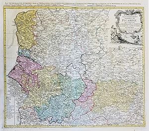
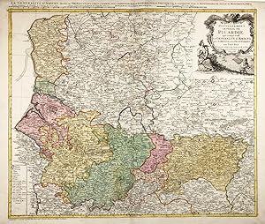
Carte du Gouvernement General de Picardie qui comprend le Generalite d'Amiens avec l'Artois & les Frontieres des Pays Bas" - Picardie Abbeville Amiens Corbie Arras Bapaume Lille Guise Moncornet Valenciennes Maubeuge Lens France Frankreich Carte
Published by N�rnberg, Homann Erben, 1746
Seller: Antiquariat Steffen V�lkel GmbH, Seubersdorf, Germany
Seller Rating:
Map
Sehr dekorativehandkolorierte Kupferstich-Karte vonJohann Baptist Homann von 1746. -- Blatt-Format: ca.55 x63 cm. - J.B. Homann war einer der bedeutendsten Kartenmacher des 18. Jahrhunderts. - leicht gebr�unt - sonst gut erhalten. / Very good condition. || Dies ist ein Original! - Kein Nachdruck! - Keine Kopie! -- This is an original! - No copy! - No reprint! Sprache: Franz�sisch.
-
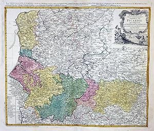
Carte du Gouvernement General de Picardie qui comprend le Generalite d'Amiens avec l'Artois & les Frontieres des Pays Bas" - Picardie Abbeville Amiens Corbie Arras Bapaume Lille Guise Moncornet Valenciennes Maubeuge Lens France Frankreich
Published by N�rnberg, Homann Erben, 1746
Seller: Antiquariat Steffen V�lkel GmbH, Seubersdorf, Germany
Seller Rating:
Map
Sehr dekorativehandkolorierte Kupferstich-Karte vonJohann Baptist Homann von 1746. -- Blatt-Format: ca.52 x61 cm. - J.B. Homann war einer der bedeutendsten Kartenmacher des 18. Jahrhunderts. - teils leicht fleckig, sonst gut erhalten. || Dies ist ein Original! - Kein Nachdruck! - Keine Kopie! -- This is an original! - No copy! - No reprint! Sprache: Franz�sisch.
-
Carte du Gouvernement General de Picardie qui comprend le Generalite d'Amiens avec l'Artois & les Frontieres des Pays Bas" - Picardie Abbeville Amiens Corbie Arras Bapaume Lille Guise Moncornet Valenciennes Maubeuge Lens France Frankreich
Published by N�rnberg, Homann Erben, 1746
Seller: Antiquariat Steffen V�lkel GmbH, Seubersdorf, Germany
Seller Rating:
Map
Sehr dekorativehandkolorierte Kupferstich-Karte vonJohann Baptist Homann von 1746. -- Blatt-Ma�e: ca. 54,5 x 65 cm. . - J.B. Homann war einer der bedeutendsten Kartenmacher des 18. Jahrhunderts. - gut erhalten. || Dies ist ein Original! - Kein Nachdruck! - Keine Kopie! -- This is an original! - No copy! - No reprint! Sprache: Franz�sisch Gewicht in Gramm: 30.
-
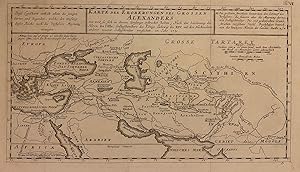
Karte der Eroberungen des Grossen Alexanders
Published by J. Senex, Paris, 1705
Seller: Argosy Book Store, ABAA, ILAB, New York, NY, U.S.A.
Seller Rating:
unbound. Map. Engraving with hand coloring. Image measures 7 1/2" x 13 5/8" Beautiful classical map of the Middle East showing the extent of Alexander the Great's conquests. Centered on Persia, the maps spans the vast region from the Tyrrhenian Sea to the Ganges River. Text in German. Guillaume Delisle (1675-1726) was a legendary French cartographer known for introducing a new standard of accuracy into 17th-century mapmaking. He was one of the cartographers who propelled the French school of map-making away from Dutch dominance. The French school emphasized science and accuracy over ornament. His family took over the business and kept publishing maps well into the late 18th century. He used astronomical observations to determine locations and draw more precise coastlines. He continually updated his maps and dispelled prevailing geographical inaccuracies throughout his life. John Senex (1678-1740) was a kind of Renaissance man of the 18th-century map world, working at times as a scholar, surveyor, engraver, astrologer, book seller and publisher of maps, atlases and globes. In a short period, he developed from an apprentice into one of the most important cartographers of the period and became a Fellow of the Royal Society of London, as well as Official Geographer to Queen Anne of Great Britain. Although well regarded for his pocket-size maps, Senex is probably best known for his globes, which display a knowledge of astronomy equal to the skill of their craftsmanship. After his death in 1740 his wife Mary continued his business and continued to produce and sell cartographic works of high quality. Together, their work represents a successful and valuable partnership in 18th-century mapmaking and publishing.
-
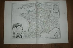
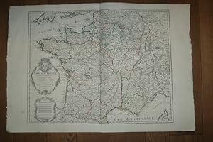
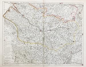
La France. Dress�e sur un grand nombre de Cartes particulieres manuscrites ou imprim�e lev�es sur les lieux. Teilkolorierte Kupferstichkarte.
Published by A Paris, De L'Isle, 1703
Map
Condition: Gut. 49 x 67 cm (Blattgr��e: 54,5 x 81 cm). *Fr�he Delisle-Karte, zeigt detailliert das gesamte Frankreich. Gro�e Titelkartusche unten links. - Guillaume Delisle (1675-1726) war ein franz�sischer Kartograph aus Paris. Delisle war der erste, der eine wissenschaftlich vergleichende Geographie anbahnte, indem er bei seinen Werken auch Reiseberichte und die Werke von Naturforschern benutzte. Er gab zahlreiche Landkarten heraus, die sich durch Eleganz und Sch�rfe von den fr�heren Karten unterschieden. - Der breite wei�e Rand wurde zeitgen�ssisch eigens aufmontiert. Linker Au�enrand mit kleinem Tintenfleckchen, insgesamt sauber und gut erhalten. / Early print of this Delisle map. The large white edges were mounted separate in contemporarily time. Good condition. Sprache: Deutsch Gewicht in Gramm: 1000.
-
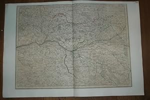
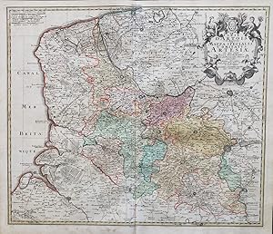
Carte du Bourdelois, du Perigord et des Provinces voisines. Teilkolorierte Kupferstichkarte mit Grenz- und Fl�chenkolorit.
Published by A Paris, De L'Isle, 1714
Map
Condition: Gut. 71 x 64 cm (Blattgr��e: 76 x 80,5 cm). *Fr�he Delisle-Karte, eine zweite (gr��ere) Variante unter diesem Titel (und in gleichem Ma�stab). Sie ist gr��er als die andere Karte (nochmals aufgeklappt) und enth�lt den gesamten S�dwesten Frankreichs. Die Karte zeigt das Gebiet des Bordeaux Weines und Perigord mit den Flu�gebiet der Garonne und reicht s�dlich bis zur Spanischen Grenze. Es sind die St�dte Bordeaux (im n�rdl. Teil) sowie Bayonne und Toulouse im s�dlichen Teil bis an die Pyren�en enthalten. - Guillaume Delisle (1675-1726) war ein franz�sischer Kartograph aus Paris. Delisle war der erste, der eine wissenschaftlich vergleichende Geographie anbahnte, indem er bei seinen Werken auch Reiseberichte und die Werke von Naturforschern benutzte. Er gab zahlreiche Landkarten heraus, die sich durch Eleganz und Sch�rfe von den fr�heren Karten unterschieden. - Der breite wei�e Rand wurde zeitgen�ssisch eigens aufmontiert. Im Mittelfalz unten mit Einri� im wei�en Rand. Seitliche R�nder mit Altersbr�unung. Insgesamt gut erhalten. / Early print of this Delisle map. The large white edges were mounted separate in contemporarily time. A small tear in outline margin, altogether in good condition. Sprache: Deutsch Gewicht in Gramm: 1000.
-

P, Dezauche , 1780 , carte 66 x 51 cm Contours des provinces colori�es � l' �poque, mouillure claire sur la partie inf�rieure. Langue: Fran�ais Livres.
-
P, Dezauche , 1780 , carte 66 x 49 cm Contours des provinces colori�es � l' �poque, restauration discr�te � la pliure petits manques de papier dans les coins. Livres.
-
Carte d'Artois et des Environs Vel Mappa Specialis Comitatus Artesiae." - Artois Lille Hesdin Bethune Calais Gravelines Saint Omer Arras Douay Bapaume Cambrai Lens carte Karte map
Published by N�rnberg, Homann Erben, 1750
Seller: Antiquariat Steffen V�lkel GmbH, Seubersdorf, Germany
Seller Rating:
Map
Original altkolorierte Kupferstich-Karte von ca. 1750. -- Blatt-Ma�e: ca. 60 x 52 cm. -- gut erhalten. || Original old colored copper engraved map from around 1750. -- in good condition. || Dies ist ein Original! - Kein Nachdruck! - Keine Kopie! -- This is an original! No copy! - No reprint! Sprache: Franz�sisch Gewicht in Gramm: 1550.
-

Carte d'Artois et des Environs Vel Mappa Specialis Comitatus Artesiae." - Artois Lille Hesdin Bethune Calais Gravelines Saint Omer Arras Douay Bapaume Cambrai Lens carte Karte map
Published by N�rnberg, Homann Erben, 1750
Seller: Antiquariat Steffen V�lkel GmbH, Seubersdorf, Germany
Seller Rating:
Map
Original altkolorierte Kupferstich-Karte von ca. 1750. -- Blatt-Ma�e: ca. 55 x 64 cm. -- gut erhalten. || Original old colored copper engraved map from around 1750. -- in good condition. || Dies ist ein Original! - Kein Nachdruck! - Keine Kopie! -- This is an original! No copy! - No reprint! Sprache: Franz�sisch Gewicht in Gramm: 1550.
-
Partie Meridionale de Picardie" - Picardie Abbeville Amiens Corbie Doullens Peronne Montdidier Ham carte gravure
Published by Paris, Dezauche ca. 1780., 1780
Seller: Antiquariat Steffen V�lkel GmbH, Seubersdorf, Germany
Seller Rating:
Map
Original altkolorierte Kupferstich-Karte von ca. 1780. -- Blatt-Ma�e: ca. 54 x 75 cm. -- im Mittelbug hinterlegt, mit kleinem hinterlegtem Randeinriss, sonst gut erhalten. || Original old colored copper engraved map from c. 1780. -- with minor deposited marginal tear, deposited on the centerfold, otherwise in good condition. || Dies ist ein Original! - Kein Nachdruck! - Keine Kopie! -- This is an original! No copy! - No reprint! Sprache: Franz�sisch Gewicht in Gramm: 1550.