
Order Total (1 Item Items):
Shipping Destination:

Gilbert Johnsons Universal Cyclopaedia Adams (1 results)
Feedback
Skip to main search results
Search filters
Product Type
- All Product Types
- Books (1)
- Magazines & Periodicals (No further results match this refinement)
- Comics (No further results match this refinement)
- Sheet Music (No further results match this refinement)
- Art, Prints & Posters (No further results match this refinement)
- Photographs (No further results match this refinement)
- Maps (No further results match this refinement)
- Manuscripts & Paper Collectibles (No further results match this refinement)
Condition
- All Conditions
- New (No further results match this refinement)
- Used (1)
Binding
- All Bindings
- Hardcover (No further results match this refinement)
- Softcover (No further results match this refinement)
Collectible Attributes
- First Edition (No further results match this refinement)
- Signed (No further results match this refinement)
- Dust Jacket (No further results match this refinement)
- Seller-Supplied Images (1)
- Not Print on Demand (1)
Free Shipping
- Free Shipping to United Kingdom (No further results match this refinement)
Seller Rating
-
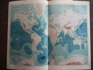
Johnson's Map of the Earth Showing height of land and depth of Sea on the Mercator projection, - Original (1895)
Published by A. J. Johnson Company, 1895
Seller: Imperial Books and Collectibles, Wauwatosa, WI, U.S.A.
Seller rating 5 out of 5 stars

No Binding. Condition: Fine. This rare colored engraved Map of the Earth Showing height of land and depth of Sea on the Mercator projection, drawn and prepared by G. K. Gilbert based chiefly on compilations by J. G. Bartholomew and Henry Gannett, is from Volume II of the 1895 edition the highly acclaimed Johnson's Universal Cyclopaedia. Plate size: 9 1/2" x 12" (24 x 30.5 cm); Condition: Fine; Central fold, as issued. All items carefully packed to avoid damage from moisture and rough handling.