Order Total (1 Item Items):
Shipping Destination:

Blaeu Johannes (198 results)
Skip to main search results
Product Type
- All Product Types
- Books (99)
- Magazines & Periodicals
- Comics
- Sheet Music
- Art, Prints & Posters (11)
- Photographs
- Maps (88)
- Manuscripts & Paper Collectibles
Condition
Binding
Collectible Attributes
- First Edition (11)
- Signed (1)
- Dust Jacket (6)
- Seller-Supplied Images (179)
- Not Print on Demand (194)
Free Shipping
- Free US Shipping
Seller Location
Seller Rating
-
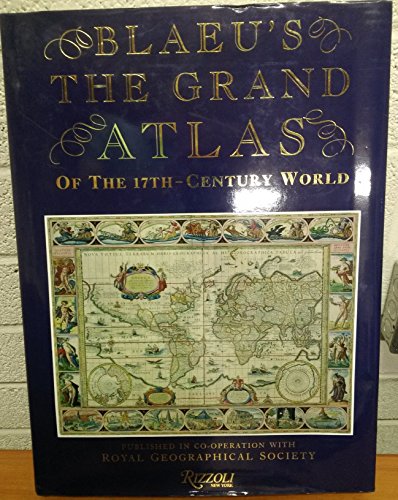
Blaeu's The Grand Atlas Of The 17th Century World
Published by Rizzoli, 1991
ISBN 10: 0847813002ISBN 13: 9780847813001
Book
Condition: Very Good. May have light to moderate shelf wear and/or a remainder mark. Complete. Clean pages.
-
![Seller image for Gerardi Ioannis Vossii Dissertationes tres de tribus symbolis, Apostolico, Athanasiano et Constantinopolitano (1642) [LeatherBound] for sale by True World of Books](https://pictures.abebooks.com/inventory/md/md31657291447.jpg)
LeatherBound. Condition: New. LeatherBound edition. Condition: New. Reprinted from 1642 edition. Leather Binding on Spine and Corners with Golden leaf printing on spine. Bound in genuine leather with Satin ribbon page markers and Spine with raised gilt bands. A perfect gift for your loved ones. NO changes have been made to the original text. This is NOT a retyped or an ocr'd reprint. Illustrations, Index, if any, are included in black and white. Each page is checked manually before printing. As this print on demand book is reprinted from a very old book, there could be some missing or flawed pages, but we always try to make the book as complete as possible. Fold-outs, if any, are not part of the book. If the original book was published in multiple volumes then this reprint is of only one volume, not the whole set. Sewing binding for longer life, where the book block is actually sewn (smythe sewn/section sewn) with thread before binding which results in a more durable type of binding. Pages: 114.
-
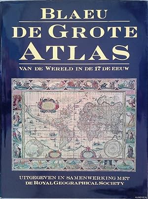
De grote atlas van de wereld in den 17de eeuw
Published by Lisse, Zuid Boekproducties, 1992
ISBN 10: 9062487386ISBN 13: 9789062487387
Book
Condition: Good. Originele hardcover met goudopdruk op rug, stofomslag, veel grote afbeeldingen in kleur.
-
![Seller image for Horti medici amstelodamensis rariorum tam Orientalis ?qua?m Occidentalis India, aliarumque peregrinarum plantarum, magno studio ac labore, sumptibus Civitatis amstelodamensis, longa? annorum serie collectarum, descriptio et icones ad vivum ari incisa /auctore Joanne Commelino. Opus posthumum, latinitate donatum, notisque & observationibus illustratum, a? Frederico Ruyschio & Francisco Kiggelario. Volume 2 [LeatherBound] for sale by True World of Books](https://pictures.abebooks.com/inventory/md/md31532895781.jpg)
Horti medici amstelodamensis rariorum tam Orientalis ?qua?m Occidentalis India, aliarumque peregrinarum plantarum, magno studio ac labore, sumptibus Civitatis amstelodamensis, longa? annorum serie collectarum, descriptio et icones ad vivum ari incisa /auctore Joanne Commelino. Opus posthumum, latinitate donatum, notisque & observationibus illustratum, a? Frederico Ruyschio & Francisco Kiggelario. Volume 2 [LeatherBound]
Publication Date: 2023
Book Print on Demand
LeatherBound. Condition: New. LeatherBound edition. Condition: New. Reprinted from 1697 edition. Leather Binding on Spine and Corners with Golden leaf printing on spine. Bound in genuine leather with Satin ribbon page markers and Spine with raised gilt bands. A perfect gift for your loved ones. NO changes have been made to the original text. This is NOT a retyped or an ocr'd reprint. Illustrations, Index, if any, are included in black and white. Each page is checked manually before printing. As this print on demand book is reprinted from a very old book, there could be some missing or flawed pages, but we always try to make the book as complete as possible. Fold-outs, if any, are not part of the book. If the original book was published in multiple volumes then this reprint is of only one volume, not the whole set. Sewing binding for longer life, where the book block is actually sewn (smythe sewn/section sewn) with thread before binding which results in a more durable type of binding. Pages: 328 Volume 2.
-
![Seller image for Horti medici amstelodamensis rariorum tam Orientalis ?qua?m Occidentalis India, aliarumque peregrinarum plantarum, magno studio ac labore, sumptibus Civitatis amstelodamensis, longa? annorum serie collectarum, descriptio et icones ad vivum ari incisa /auctore Joanne Commelino. Opus posthumum, latinitate donatum, notisque & observationibus illustratum, a? Frederico Ruyschio & Francisco Kiggelario. Volume 1 [LeatherBound] for sale by True World of Books](https://pictures.abebooks.com/inventory/md/md31532894861.jpg)
Horti medici amstelodamensis rariorum tam Orientalis ?qua?m Occidentalis India, aliarumque peregrinarum plantarum, magno studio ac labore, sumptibus Civitatis amstelodamensis, longa? annorum serie collectarum, descriptio et icones ad vivum ari incisa /auctore Joanne Commelino. Opus posthumum, latinitate donatum, notisque & observationibus illustratum, a? Frederico Ruyschio & Francisco Kiggelario. Volume 1 [LeatherBound]
Publication Date: 2023
Book Print on Demand
LeatherBound. Condition: New. LeatherBound edition. Condition: New. Reprinted from 1697 edition. Leather Binding on Spine and Corners with Golden leaf printing on spine. Bound in genuine leather with Satin ribbon page markers and Spine with raised gilt bands. A perfect gift for your loved ones. NO changes have been made to the original text. This is NOT a retyped or an ocr'd reprint. Illustrations, Index, if any, are included in black and white. Each page is checked manually before printing. As this print on demand book is reprinted from a very old book, there could be some missing or flawed pages, but we always try to make the book as complete as possible. Fold-outs, if any, are not part of the book. If the original book was published in multiple volumes then this reprint is of only one volume, not the whole set. Sewing binding for longer life, where the book block is actually sewn (smythe sewn/section sewn) with thread before binding which results in a more durable type of binding. Pages: 344 Volume 1.
-
![Seller image for Ioh. Antonidae vander Linden . De scriptis medicis libri duo [LeatherBound] for sale by True World of Books](https://pictures.abebooks.com/inventory/md/md31532941170.jpg)
Ioh. Antonidae vander Linden . De scriptis medicis libri duo [LeatherBound]
Publication Date: 2023
Book Print on Demand
LeatherBound. Condition: New. LeatherBound edition. Condition: New. Reprinted from 1651 edition. Leather Binding on Spine and Corners with Golden leaf printing on spine. Bound in genuine leather with Satin ribbon page markers and Spine with raised gilt bands. A perfect gift for your loved ones. NO changes have been made to the original text. This is NOT a retyped or an ocr'd reprint. Illustrations, Index, if any, are included in black and white. Each page is checked manually before printing. As this print on demand book is reprinted from a very old book, there could be some missing or flawed pages, but we always try to make the book as complete as possible. Fold-outs, if any, are not part of the book. If the original book was published in multiple volumes then this reprint is of only one volume, not the whole set. Sewing binding for longer life, where the book block is actually sewn (smythe sewn/section sewn) with thread before binding which results in a more durable type of binding. Pages: 757.
-
Madrid, 2000. Editado por Libsa, Carton� editorial. 39 x 28 cm. 223 pp. Contiene ilustraciones a color. Geografia.
-

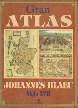
Gran Atlas de Johannes Blaeu Siglo Xvii
Published by Libsa, Editorial S.A.
ISBN 10: 8476308140ISBN 13: 9788476308141
Book
Condition: Muy bueno. LIBSA Madrid 2000 1.� EDICI�N FACSIMIL Edici�n Muy ilustrado. 223 p�ginas. Carton� Con Sobrecubierta Estado: Como nuevo Dimensiones: 28,5 x 38,5 ATLAS EAN: 9788476308141 Tipo: Libros Categor�a: T�tulo: Gran Atlas de Johannes Blaeu Siglo XviiAutor: BLAEU, JOHANNES Editorial: LIBSA, Madrid Formato: Libro de bolsillo.
More buying choices from other sellers on AbeBooks
New offers from � 219.27
Used offers from � 40.81
Also find Hardcover Softcover First Edition
-
![Seller image for Namur / Nam�r / Hennegau. - Historische Kupferstichkarte. Comitatuum Hannoniae et Namurci descriptio. [Grafschaft Hennegau, frz: Hainaut in Belgien nebst angrenzender Gebiete. Wahrscheinlich aus: van der Krogt, Koeman's Atlantes Neerlandici, Vol. I.] for sale by Antiquariat Carl Wegner](https://pictures.abebooks.com/inventory/md/md14339280276.jpg)
Namur / Nam�r / Hennegau. - Historische Kupferstichkarte. Comitatuum Hannoniae et Namurci descriptio. [Grafschaft Hennegau, frz: Hainaut in Belgien nebst angrenzender Gebiete. Wahrscheinlich aus: van der Krogt, Koeman's Atlantes Neerlandici, Vol. I.]
Published by [Johannes Janssonius (Jansson). Amsterdam, 1636.], 1636
First Edition
Softcover. Kartengr��e: 49 x 51,5 cm. Oben links einEngel die Meilenanzeige haltend, unten rechts die Titelkartusche von zwei Wappen flankiert: rechts vier L�wen unter einer Krone (das Wappen von Hennegau), rechts ein L�we unter einer Krone (das Wappen Belgiens). Im unteren Randbereich ein 2 cm langer Einriss, der bis in die Karte hineinreicht, sonst im Randbereich kleinere Fehlstellen und Einrisse. Der Kartenbereich im unteren rechten Eck nur in der Randung mit L�ngen- und Breitengraden etwas abgerieben. Weiterhin auf der Karte: Wallonien, Mons, Teile von Brabant begrenzt durch Oudenaarde, Huy und Cambrai, oben links Flandern. - Versand als Rolle zu 5.-Euro. - -- Bitte Portokosten au�erhalb EU erfragen! / Please ask for postage costs outside EU! / S ' il vous plait demander des frais de port en dehors de l ' UE! -- Genie�en Sie den Sommer und bestellen Sie was zum Lesen! Fe2Klavier.
-

Condition: Bueno. 21338 Blaeu, Johannes 1999 Libsa, Madrid, 1999. Carton� edit. con sobrecub., multitud de mapas a color. 223 pp. Gran formato Cartograf�a,Atlas.
-
GRAN ATLAS JOHANNES BLAEU SIGLO XVII -CON REPRODUCCIONES A COLOR DE MAPAS HISTORICOS-ILUSTRAC. A TODO COLOR
Published by LIBSA -ROYALL GEOGRAPHICAL SOCIETY, 1991
Condition: ESTADO MUY BUENO. TAPA BLANDA RUSTICA EDITORIAL.
-
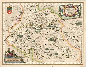
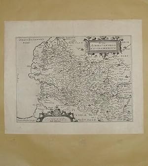
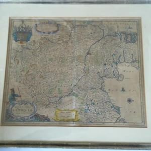
Ducatus Turonensis - Gorgeous 17th century map of the traditional French province of Touraine.
Publication Date: 1635
Seller: Curtis Wright Maps, Berwyn, IL, U.S.A.
Seller Rating:

Condition: Fine. This attractive hand colored map shows the traditional French province of Touraine, in the center of the country. The Loire River can be seen horizontally bisecting the image, with the provincial capital of Tours found on its bank. The coat of arms of the city is shown in the upper left. The region's abundant agriculture and viticulture is referenced in the decorative cartouches found in the upper right and lower left corners. It's likely that several of the abbeys and wineries shown on the map are still producing today. Published in 1635 by Willem and Johannes Blaeu. Sheet Width (in) 20.5 Sheet Height (in) 16 Condition Description One small damp stain in the left margin that just touches the neatline and faint wear along the centerfold. Features lovely hand color.
-
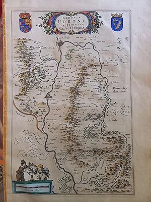
County Carlow, Ireland - "Baronia Udrone in Comitatu Cathersoughae Original Map 1645
Published by Blaeu, Amsterdam, 1645
Map First Edition
No Binding. Condition: Good. 1st Edition. Original Blaeu of map of County Carlow, image size approx 25 x 38cm. A good copy with some staining to the margins, the paper is a bit toned, hand coloured, possibly later.
-
Corpus Juris Civilis
Published by Amstelodami, : Sumptibus Societatis, ex typographia P. & I. Blaev, prostant apud Waesbergios, Boom, � Someren & Goethals, 1700
Book First Edition
Hardcover. Condition: Fair. 1st Edition. 1st thus. 'Editio nova, prioribus correctior'. 2 volumes in 1 book, 1037 & 820 pages in Latin : 21 cm. worn leather covers & spine, occasional contemporary notes in pen, foxing to endpapers. internally Good. 17th century legal commentary which remained the basis for dealing with Roman law well into the 19th century.
-
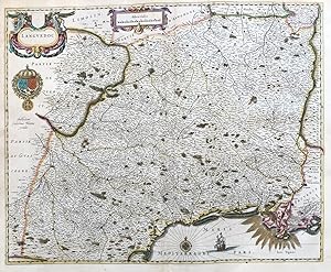
"Cadurcium Vernacul� Querci" - Quercy Cahors Occitanie Lot Montauban Souillac France Frankreich carte
Published by Amsterdam ca. 1640., 1640
Seller: Antiquariat Steffen V�lkel GmbH, Seubersdorf, Germany
Seller Rating:
Map
Gro�e altkolorierte Kupferstich-Karte von ca. 1640. -- Mit lateinischem Text auf der R�ckseite. -- Blatt-Ma�e: ca. 50 x 59 cm. -- gut erhalten. || Large old colored map from ca. 1640. With Latin text on verso. -- in good condition. || Dies ist ein Original! - Kein Nachdruck! - Keine Kopie! -- This is an original! - No copy! - No reprint! la.
-
Condition: Fair-to-Good. PARS BOREALIOR IUTIAE SEPTENTRIONALIS. North Jutland. Denmark. BLAEU c1667 map. Original large folio 17th century antique map with wide margins. Uncoloured; Joan/Johannes Blaeu (c1667). 47.0 x 60.5cm, 18.5 x 24 inches; this is a folding map. Condition: Fair-to-Good: Offsetting - text and/or images from the facing page have left an impression on the print. The text on reverse side, which relates to the map, is printed in Spanish. The Spanish text edition is extremely rare. Other places marked or shown on the map include Aarhus, Wiborg (Viborg), Lemwiig (Lemvig - Struer), Grinaa (Grenaa), Randers, Hodesbro (Holstebro), Thysted (Thisted).
-
Condition: Fair-to-Good. PARS AUSTRALIOR IUTIAE SEPTENTRIONALIS. North Jutland Denmark.BLAEU c1667 map. Original large folio 17th century antique map with wide margins. Uncoloured; Joan/Johannes Blaeu (c1667). 47.5 x 61.0cm, 18.75 x 24 inches; this is a folding map. Condition: Fair-to-Good: Offsetting - text and/or images from the facing page have left an impression on the print. The text on reverse side, which relates to the map, is printed in Spanish. The Spanish text edition is extremely rare. Other places marked or shown on the map include Aarhus, Wiborg (Viborg), Lemwiig (Lemvig - Struer), Rinkobing, Warde (Varde), Rube (Ribe), Haderschleben (Haderslev), Kolding, Middelfaer (Middelfart), Weile (Vejle), Horsens, Grinaa (Grenaa), Randers, Hodesbro (Holstebro).
-
1 carte 39 x 50 cm noir et blanc XVIIe extraite d'une �dition fran�aise de l'atlas de Johannes Blaeu. Une toute petite tache brune et une tr�s l�g�re d�chirure en charni�re sup�rieure sans atteinte � la carte. Tr�s bon �tat. NOTICE FOR FOREIGN CUSTOMERS : The ECONOMIC SHIPPING RATE is reserved by FRENCH POST for books whose weight is less than 2KG ! We have limited too this offer for books whose value is less than 30 euros. Shipping will increase if you choose this rate for a value or heavy book. If you select a Paypal payment in this particular case we cannot change the shipping rate on Abebooks but this one will increase in the Paypal invoice. So be careful please to select the appropriate shipping rate taking into consideration the book value or the weight or both.
-
Inferioris Saxoniae Circulus (Niedersachsen und Ostsee) - Teilcolorierte Karte im Kupferstich
Book
(Amsterdam, um 1660). Plattenma�: ca. 60 x 49 cm, hinter Glas, im Passepartout, in Berliner Leiste gerahmt (ca. 68,5 x 58,7 cm), (gebr�unt)---Verlag: Ohne Verlag: Ohne 2570 Gramm.
-
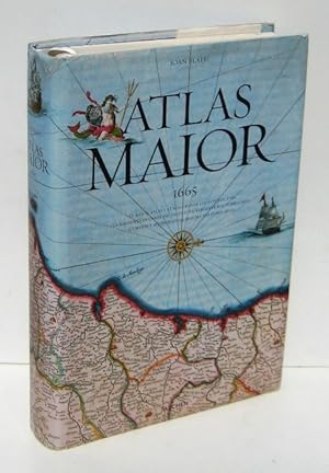
ATLAS MAIOR (1665) Geographia, qae est Cosmographiae blavianae pars prima, qua orbis terrae (.)
Published by TASCHEN, K�ln, 2005
ISBN 10: 3822841552ISBN 13: 9783822841556
Book
. 593 pp. 44,5x29,5 cm. Magn�fica edici�n en papel cartulina de calidad; ilustrada con espectaculares im�genes en color, casi todas a toda y doble p�g. 7 hojas desplegables, 4 cu�druples y 3 dobles; conteniendo mapas de todo el mundo, detalles y otras otras ilustraciones, y algunas fotos. (textos en espa�ol, italiano y portugu�s) (cosido un poco abierto en alg�n pliego, 1 l�mina reparada) (hasta 8 kilos con carton) GEOGRAFIA ATLAS HISTORIA CARTOGRAFIA MAPAS FACSIMIL 86176 LL-B9 Buen estado general, sobrecubiertra con leves roces y rasgaduras reparadas en bordes Cartone ilustrado, con sobrecubierta Y cinta gu�a.
-
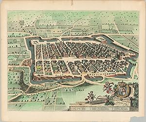
Sancti Damiani Oppidum - Beautiful view of an Italian commune (township) in Piedmont.
Published by c. 1700, 1700
Seller: Curtis Wright Maps, Berwyn, IL, U.S.A.
Seller Rating:
Condition: Very Good. This attractive copperplate engraved sheet provides a late 17th-century aerial perspective of the Italian municipality known as San Damiano d'Asti. The medieval town is situated in the Piedmont region and exchanged hands between the Holy Roman Empire, France, and local Italian leaders numerous times over its long history. Crumbling fortifications are encircled by a large moat and several bridges, built using a combination of earth and masonry. Clusters of apartments, gardens, offices, churches, and courtyards are shown amid neatly ordered streets. Six notable locations including ancient Roman ruins, the Tower, and the Parochial Temple of St. Mary, are identified in the lower right, beneath the decorative title cartouche. The image was first designed and published by Johannes Blaeu in the 1680s, but was re-issued in a number of different volumes in subsequent decades. Sheet Width (in) 26.6 Sheet Height (in) 22.4 Condition Description Chipped lower right corner and discoloration in the upper center (confined to the margin) from old tape repairs. Bright, modern hand color atop a crisp impression. Printed on thick laid paper. Blank on verso, but there are several pieces of archival tape where previously matted. About good condition overall.
-
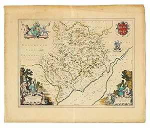
Monumethensis Comitatus. Vernacule Monmouth Shire.
Seller: John Windle Antiquarian Bookseller, ABAA, San Francisco, CA, U.S.A.
Association Member: ABAA ILAB IOBA
Seller Rating:
[Novus Atlas: 1643]. Folio 20 x 24", hand-colored engraving 15 x19 1/2", two cartouches with pastoral figures and putti, the Royal coat of arms, the local coat of arms, and a plumed crown with "Sche Diene" along the rim, Latin text to verso. � From an early edition of Blaeu's atlas which focused on England and Wales. This brightly colored, decorative map describes the county in the south east of Wales which in Welch is Sir Fynwy. Skelton 28.
-
Condition: Good. DUCATUS SLESWICI PARS BOREALIS. Duchy of Schleswig N. Denmark. BLAEU c1667 map. Original large folio 17th century antique map. Uncoloured; Joan/Johannes Blaeu (c1667). 44.0 x 62.5cm, 17.25 x 24.5 inches; this is a folding map. Condition: Good. Please contact us if you would like to arrange to view this map. The text on reverse side, which relates to the map, is printed in Spanish. The Spanish text edition is extremely rare. Other places marked or shown on the map include Northern Friesland (Nordfriesland, North Frisia), Tonder, Lugum Closter (L�hmcloster), Hatersleb (Haderslev), Apenrade (Aaabenraa), Colding (Kolding), Mittelfardt (Middelfart), Rypen (Ribe).
-
Condition: Good. PRAEFECTUR� GOTTORPIENSIS AUSTRALIS.Eckernforde Friedrichstadt.BLAEU c1667 map. Original large folio 17th century antique map. Uncoloured; Joan/Johannes Blaeu (c1667). 43.5 x 63.0cm, 17 x 24.75 inches; this is a folding map. Condition: Good. Please contact us if you would like to arrange to view this map. The text on reverse side, which relates to the map, is printed in Spanish. The Spanish text edition is extremely rare. Other places marked or shown on the map include Sleswigh (Schleswig), Eckernfoerde (Eckernforde), Rendsborg (Rendsburg), Fridrichstadt (Friedrichstadt), Swabstede (Schwabstedt).
-
![Seller image for [Original etching and engraving/ets en gravure] 'De Ghelegentheyt ende Belegheringhe van Schencken Schans'; Siege of Schenkenschans, 1635-1636. for sale by Antiquariaat Arine van der Steur / ILAB](https://pictures.abebooks.com/inventory/md/md30408855410.jpg)
[Original etching and engraving/ets en gravure] 'De Ghelegentheyt ende Belegheringhe van Schencken Schans'; Siege of Schenkenschans, 1635-1636.
Seller: Antiquariaat Arine van der Steur / ILAB, Den Haag, Netherlands
Seller Rating:
Map of the Siege and capture of Schenckenschans, located between the rivers Rhine and Waal, by a Dutch army under Frederick Henry (Frederik Hendrik), 1635-1636. With view of the surrounding area including the fortifications and details on the Siege. Title in cartouche above: 'De Ghelegentheyt ende Belegheringhe van Schencken Schans Curyeus gemeeten ende geteeckent by den ervaren Ingenieur Ioannes Iacobi Schort Anno 1635. en 36'; legend to numbers 1 to 25 in cartouche in upper left; compass rose in upper right corner; profiles of the fortifications. Address below: 'I B excudebat'. Used in: Novum ac Magnum Theatrum Urbium, Amsterdam, Joan Blaeu, 1649. Etching and engraving on laid paper, with margins; letterpress text on verso; platemark: 474 x 573 mm; total: 507 x 641 mm; watermark: Atlas holding the celestial spheres; frayed edges, some foxing in the margins. Muller 1744.
-
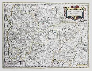
"Monasteriensis Episcopatus" - Bistum M�nster Bad Bentheim Osnabr�ck Rheine Quakenbr�ck Meppen Nordrhein-Westfalen map Karte
Published by Amsterdam, 1649
Seller: Antiquariat Steffen V�lkel GmbH, Seubersdorf, Germany
Seller Rating:
Map
Blatt-Masse ca. 48,5 x 59 cm - Platte ca. 38 x 50,5 cm - Original handkolorierte Kupferstich-Karte von 1649. R�ckseitig mit deutschem Text. - Aus Blaeu's "Novus Atlas, Das ist Weltbeschreibung mit sch�nen newen au�f�hrlichen Land-Taffeln in Kupffer gestochen und an den tag gegeben". - gut erhalten -- Rare hand-coloured engraved map from the German edition of Blaeus Novus Atlas from 1649. With German text on verso. -- in good condition.|| Dies ist ein Original! - Kein Nachdruck! - Keine Kopie! -- This is an original! - No copy! - No reprint! Sprache: Deutsch Gewicht in Gramm: 1500.
-
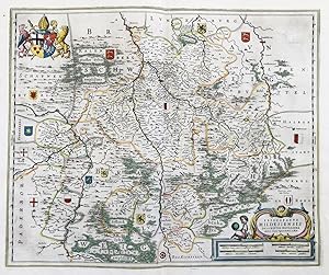
"Episcopatus Hildesiensis Descriptio Novissima" - Bistum Hildesheim Einbeck Hameln Goslar Wolfenb�ttel Niedersachsen map Karte
Published by Amsterdam, 1649
Seller: Antiquariat Steffen V�lkel GmbH, Seubersdorf, Germany
Seller Rating:
Map
Blatt-Masse ca. 48,5 x 59 cm - Platte ca. 38 x 50,5 cm - Original handkolorierte Kupferstich-Karte von 1649. R�ckseitig mit deutschem Text. - Aus Blaeu's "Novus Atlas, Das ist Weltbeschreibung mit sch�nen newen au�f�hrlichen Land-Taffeln in Kupffer gestochen und an den tag gegeben". - gut erhalten -- Rare hand-coloured engraved map from the German edition of Blaeus Novus Atlas from 1649. With German text on verso. -- in good condition. || Dies ist ein Original! - Kein Nachdruck! - Keine Kopie! -- This is an original! - No copy! - No reprint! Sprache: Deutsch Gewicht in Gramm: 1500.
-
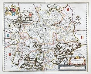
"Episcopatus Hildesiensis Descriptio Novissima" - Bistum Hildesheim Einbeck Hameln Goslar Wolfenb�ttel Niedersachsen
Published by Amsterdam ca. 1640., 1640
Seller: Antiquariat Steffen V�lkel GmbH, Seubersdorf, Germany
Seller Rating:
Map
Gro�e altkolorierte Kupferstich-Karte von ca. 1640. -- Mit lateinischem Text auf der R�ckseite. -- Blatt-Ma�e: ca. 49,5 x 59 cm. -- gut erhalten. || Large old colored map from c. 1640. With Latin text on verso. -- in good condition. || Dies ist ein Original! - Kein Nachdruck! - Keine Kopie! -- This is an original! - No copy! - No reprint! la.
-
Carte de 1612 repr�sentant le Nord, Pas-de-Calais, Artois. Grav�e par � Ihoannes a Doetechum iunior fecit � pour Lodovico Guicciardini pour l'ouvrage publi� par Willem Blaeu � Amsterdam � Beschryvinghe van alle de andersins neder-landen ghenoemt neder-duytslandt �. De format (cuvette) 32 par 23,5 cm. Bel exemplaire bien frais, grand de marge, verso sans inscriptions.
-
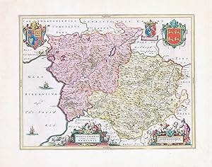
MONTGOMERIA COMITATUS ET COMITATUS MERVINIA - A fine original antique map of MONTGOMERSHIRE by Blaeu with original and contemporary hand colour. Verso blank. Overall size approx 61cm x 49cm. Condition is excellent with central fold as issued.

![Seller image for Pars Borealior Iutiae Septentrionalis in qua dioceses Alburgensis et Viburgensis [The northern part of north Jutland, in which are the dioceses of Aalborg/�lborg and Viborg] for sale by Antiqua Print Gallery](https://pictures.abebooks.com/inventory/md/md31102178459.jpg)
![Seller image for Pars Australior Iutiae Septentrionalis, in qua dioceses Ripensis et Arhusiensis [The southern part of northern Jutland, in which are the dioceses of Ribe & Aarhus/�rhus] for sale by Antiqua Print Gallery](https://pictures.abebooks.com/inventory/md/md31102180024.jpg)
![Seller image for Ducatus Sleswici pars Borealis [Northern part of the Duchy of Schleswig] for sale by Antiqua Print Gallery](https://pictures.abebooks.com/inventory/md/md31102174724.jpg)
![Seller image for Praefecturae Gottorpiensis pars Australis;Grundtri� von Fridrichstadt; Grundtri� der stadt Eckernfoerde [The southern part of the prefecture of Gottorf (Gottorp). Inset, plan of the towns of Eckernforde & Friedrichstadt] for sale by Antiqua Print Gallery](https://pictures.abebooks.com/inventory/md/md31102181976.jpg)